Guadalupe Mountains National Park: The Perfect Weekend Itinerary
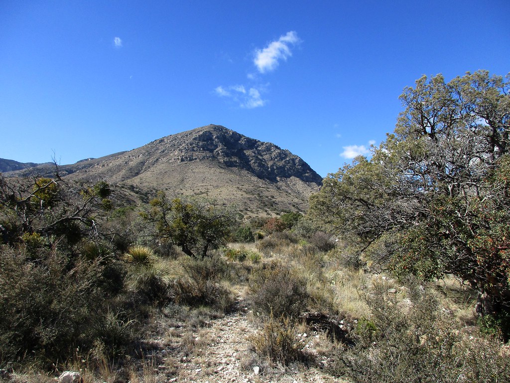
Photo: jaygannett via Flickr (CC BY-SA 2.0)
Guadalupe Mountains National Park at sunrise feels carved from light: El Capitan’s limestone face turns gold above the Chihuahuan Desert while cool air moves through the sotol and agave at Pine Springs. Underfoot, pale gravel records an ancient marine reef that formed roughly 260 million years ago, and the silence is broken by canyon wrens and wind pressing against the escarpment.
A weekend here requires deliberate planning because the park’s major destinations are separated, services are sparse, and several trails demand most of a day. Our itinerary uses Pine Springs as the primary base, reserves the clearest morning for a major hike, and places McKittrick Canyon on the final day. That sequence limits unnecessary driving while covering the park’s defining geology, high country, desert springs, and canyon forest.
Understanding Guadalupe Mountains National Park
Guadalupe Mountains National Park protects the southern end of the Guadalupe Mountains in far West Texas, close to the New Mexico state line. The range rises abruptly from the surrounding desert, culminating at 8,751-foot Guadalupe Peak, the highest natural point in Texas. El Capitan, a prominent 8,085-foot limestone cliff below the peak, served as a landmark for travelers following historic routes across the region.
The park has no scenic loop road. Most exploration happens on foot from separate trailheads at Pine Springs, Frijole Ranch, McKittrick Canyon, Salt Basin Dunes, and Dog Canyon. Pine Springs provides access to Guadalupe Peak, Devil’s Hall, and the park’s main visitor contact area. McKittrick Canyon lies along US 62 and US 180, while Dog Canyon requires a long approach through New Mexico and does not fit comfortably into a first weekend.
A fossil reef above the Chihuahuan Desert
The mountains expose part of the Capitan Reef, which developed around the margin of the Permian Delaware Sea. Reef-building organisms, lime mud, and marine debris eventually formed the durable limestone now visible in El Capitan and the canyon walls. Erosion removed softer surrounding rock, leaving the reef mass standing thousands of feet above the Salt Basin. This geology explains the park’s steep escarpments, narrow canyons, caves, and pale, angular trail surfaces.
Why elevation controls the experience
Elevation spans from about 3,600 feet near the Salt Basin Dunes to more than 8,700 feet on Guadalupe Peak. Lower slopes support creosote, yucca, agave, and sotol, while protected canyons hold oaks, maples, and springs. Higher ground supports ponderosa pine, Douglas fir, and other plants associated with cooler mountain environments. Temperatures, wind, and precipitation can therefore differ sharply between a desert trailhead and an exposed summit reached several hours later.
Route Logic for the Perfect Guadalupe Mountains National Park Weekend Itinerary
The most efficient plan begins Friday afternoon at Pine Springs or nearby Frijole Ranch, tackles Guadalupe Peak or Devil’s Hall on Saturday, and visits McKittrick Canyon on Sunday. The strenuous hike comes first because Saturday allows an early start without packing up camp. McKittrick Canyon then works well as a flexible departure-day hike, with several turnaround points for travelers driving onward to Carlsbad, El Paso, or Van Horn.
Driving between Pine Springs and McKittrick Canyon takes roughly 15 minutes, but the short distance can be misleading. McKittrick Canyon has controlled access rather than unrestricted round-the-clock entry, so the visit must fit its current opening window. Entrance procedures, campground availability, fees, water status, and canyon access times can change, so confirm current details on the official park site before leaving reliable service.
Guadalupe Mountains National Park Weekend at a Glance
This schedule assumes two nights near Pine Springs and arrival early enough on Friday for a short walk. Travelers staying in Carlsbad should add roughly an hour of driving at each end of a park day. Staying near the park protects valuable morning time, especially when high temperatures or strong winds make an early trail start important.
| Day | Primary stop | Main highlight | Approximate driving |
|---|---|---|---|
| Friday | Frijole Ranch and Pine Springs | Spring-fed desert habitat and sunset below El Capitan | 15 minutes within the park area |
| Saturday | Pine Springs trailhead | Guadalupe Peak or Devil’s Hall | Minimal if based at Pine Springs |
| Sunday | McKittrick Canyon | Pratt Cabin, The Grotto, or a shorter canyon walk | About 15 minutes from Pine Springs |
Choosing the right Saturday objective
Guadalupe Peak Trail covers about 8.4 miles round trip and gains approximately 3,000 feet. Most hikers need six to eight hours, with additional time warranted in wind, heat, or winter ice. Devil’s Hall is a less committing alternative at about 3.8 miles round trip. It follows Pine Spring Canyon before entering a rock wash and reaching a narrow limestone staircase beneath the hall.
- Choose Guadalupe Peak if everyone can sustain a steep climb, the forecast supports prolonged exposure, and reaching Texas’s highest point is the weekend priority.
- Choose Devil’s Hall for a shorter day with canyon geology, boulder travel, and time left for Frijole Ranch or Manzanita Spring.
- Avoid combining both unless the group is highly conditioned and has ample daylight, water, and stable weather.
Arrival Planning, Fuel, Food, and Overnight Bases
Pine Springs lies along US 62 and US 180, approximately 110 miles east of El Paso and about 55 miles southwest of Carlsbad, New Mexico. The El Paso drive generally takes close to two hours before stops, while Carlsbad is about an hour away. Van Horn provides another approach from Interstate 10, roughly 65 miles south of the park. Road distances are manageable, but a forgotten water container or hiking meal can require a lengthy detour.
Our team recommends arriving with a full fuel tank, all meals, and more water than the hiking plan appears to require. The developed park areas do not function like resort gateways, and visitors should not expect a full grocery selection or dependable restaurant hours beside the trailheads. El Paso, Carlsbad, and Van Horn are the practical places for substantial supplies.
Connectivity and self-sufficient packing
Cell reception is unreliable around trailheads, canyons, and mountain slopes. Download the park map, trail information, weather forecast, and offline driving directions before approaching the Guadalupe escarpment. Leave the hiking route and expected return time with someone outside the group, particularly for Guadalupe Peak, where weather exposure and slow descents can extend the day.
- Carry at least one gallon of water per person for a full-day warm-weather hike.
- Pack salty food, sun protection, a headlamp, insulating layers, and a wind-resistant shell.
- Bring a paper map or saved offline map rather than relying on live navigation.
- Use footwear suited to loose limestone, rock steps, and uneven canyon washes.
- Keep extra water, food, and warm clothing in the vehicle for delays.
Where to sleep for the shortest morning
Pine Springs is the logical overnight location for hikers attempting Guadalupe Peak because the trail begins there. Camping within the park keeps the morning simple, although exposed sites can experience powerful winds and limited shelter. Travelers preferring indoor lodging can look near Whites City or in Carlsbad, accepting the additional drive. Dog Canyon camping suits a separate northern itinerary rather than this weekend route because reaching it requires a substantial loop through New Mexico.
Friday Afternoon Below the Escarpment
Use Friday to understand the terrain rather than beginning a strenuous climb late in the day. Start at the Pine Springs area for orientation, then drive to Frijole Ranch, a historic ranching site near several dependable springs. Exhibits and building access may depend on current operations, but the surrounding landscape makes the stop useful even when indoor areas are unavailable.
Frijole Ranch also introduces the relationship between water and settlement in this dry region. Frijole Spring supported Indigenous use, later ranching, orchards, and domestic life. Nearby Manzanita Spring attracts birds and wildlife because permanent surface water is scarce across the desert slopes.
A short acclimatization walk
The Smith Spring Loop is approximately 2.3 miles and climbs from open desert vegetation into a cooler pocket around the spring. It is a sensible choice for hikers who arrive with two hours of usable daylight and want to test footwear, temperature, and altitude before Saturday. A shorter walk to Manzanita Spring works better after a delayed arrival or during high heat.
Sunset near Pine Springs
Return toward Pine Springs before dusk for views of El Capitan and the western escarpment. The limestone catches late light clearly from open areas near the highway and trailhead, while the desert floor falls into shadow first. After sunset, temperatures can drop rapidly because of elevation and dry air, so keep an insulating layer accessible rather than buried with overnight gear.
Saturday in Guadalupe Mountains National Park: The Guadalupe Escarpment
Begin before sunrise so the steepest climbing occurs in cool air. From Pine Springs, the Guadalupe Peak Trail gains elevation quickly through limestone switchbacks, crosses a more sheltered conifer zone, and then returns to exposed terrain near the summit ridge. Carry all required water because dependable natural water is unavailable along the route. Wind is often the deciding factor, especially where the trail traverses open slopes above Pine Spring Canyon.
Managing the Guadalupe Peak climb
Use time checkpoints rather than assuming the summit must be reached. A turnaround that preserves daylight and energy for the descent is the correct decision when progress slows. Loose limestone makes descending tiring, and the final miles can take longer than expected. At the 8,751-foot summit, a metal pyramid marks the highest point in Texas, with views toward El Capitan, the Salt Basin, and the desert ranges of southern New Mexico.
- Start with a controlled pace through the initial switchbacks.
- Reassess wind, water, and group condition after entering the higher forest.
- Turn around for thunder, unstable footing, or sustained winds affecting balance.
- Keep at least half the day’s water for the exposed upper mountain and descent.
Following the Devil’s Hall alternative
Devil’s Hall requires less elevation gain but involves uneven travel through a rocky drainage. After the maintained approach, hikers negotiate cobbles, boulders, and limestone ledges before climbing the natural staircase below the narrow hall. Trekking poles help on the approach but can become awkward during hands-on scrambling. Avoid entering the wash when storms could send runoff through Pine Spring Canyon, even if rain appears distant.
Recovery after the hike
Allow time to eat, rehydrate, and inspect feet before driving. Fatigue is particularly noticeable after Guadalupe Peak because the descent combines repetitive impact with loose rock. If daylight and energy remain, choose a level stroll near Pine Springs rather than adding another canyon hike. Saturday evening is also the time to organize Sunday’s food and daypack so departure for McKittrick Canyon remains efficient.
Sunday Through McKittrick Canyon
McKittrick Canyon protects a surprisingly diverse woodland beneath sheer Permian limestone walls. Bigtooth maples, gray oaks, alligator junipers, ponderosa pines, and madrones occupy cooler pockets along the drainage. The canyon is particularly well known for autumn color, but its geology and changing plant communities reward a visit in every season. Begin early enough to reach your chosen turnaround comfortably within the canyon’s access period.
Pratt Cabin as the essential destination
The hike to Pratt Cabin is approximately 4.8 miles round trip and provides the strongest choice for a half day. Geologist Wallace Pratt built the stone cabin during the 1930s using local limestone, allowing the structure to blend into the canyon floor. The relatively gentle route passes from exposed desert scrub into shaded woodland, illustrating how elevation, spring moisture, and canyon orientation create a cooler refuge.
Extending to The Grotto
Continue to The Grotto for a walk of roughly 6.8 miles round trip. Mineral deposits create textured formations inside the shallow cavern, while the nearby historic Hunter Line Cabin records the area’s ranching period. Strong hikers can continue toward The Notch, but the trail becomes markedly steeper. That extension is best reserved for travelers without a long Sunday drive.
- Two to three hours: Walk partway into the canyon and turn around before Pratt Cabin.
- Three to four hours: Make Pratt Cabin the primary objective.
- Four to five hours: Continue to The Grotto and Hunter Line Cabin.
Adjusting the Weekend for Weather and Season
Guadalupe Mountains National Park sits where desert exposure meets mountain weather. Spring frequently brings powerful winds, summer requires aggressive heat management, and winter can place ice or snow on shaded high elevation trail sections. Autumn generally provides comfortable hiking temperatures, although McKittrick Canyon’s color period draws heavier visitation. The best adjustment is usually changing the Saturday objective rather than forcing the original plan.
Seasonal itinerary changes
| Season | Likely conditions | Best itinerary adjustment |
|---|---|---|
| Spring | Strong wind, large temperature swings, occasional blowing dust | Use Devil’s Hall when exposed ridges become unsafe |
| Summer | Intense low elevation heat and afternoon thunderstorms | Start before sunrise and shorten Friday’s walk |
| Autumn | Milder temperatures and seasonal color in McKittrick Canyon | Reach the canyon early and retain a flexible turnaround |
| Winter | Cold wind with possible snow or ice at elevation | Favor lower canyon routes if the peak trail is icy |
Wind, lightning, and wildlife decisions
Exposed ridges provide little protection from lightning, and narrow washes can concentrate storm runoff. Check the sky throughout the hike rather than relying solely on a morning forecast. Mountain lions are present but rarely seen, while mule deer, javelinas, rattlesnakes, and smaller desert animals are more likely encounters. Give wildlife space, watch where hands and feet are placed around rocks, and store food securely at camp.
Gear & Essentials
Tell us about your trip and we will add what else you will want:
The basics
Worth having in the car whatever the park.
For this trip
Traveling with kids
Bringing a pet
RVing
Backcountry
Winter conditions
On the water
Photography
Accessibility
As an Amazon Associate we earn from qualifying purchases, at no extra cost to you.
Completing a Well-Paced Guadalupe Mountains National Park Weekend
This sequence gives Friday to Frijole Ranch and the spring environment, Saturday to the park’s major mountain objective, and Sunday to the shaded geology and cultural history of McKittrick Canyon. Basing the trip at Pine Springs limits driving and protects the coolest hours for hiking. Choosing between Guadalupe Peak and Devil’s Hall keeps the itinerary realistic for different fitness levels and weather conditions.
Arrive supplied, download navigation in advance, and treat wind, heat, and water as primary planning factors. With those details settled, a two-night visit can cover the defining landscapes of Guadalupe Mountains National Park without turning the weekend into a rushed checklist. The result is a practical route through desert springs, fossil reef limestone, high country, and one of West Texas’s most distinctive canyons.
Want to keep exploring? Browse all our Guadalupe Mountains guides and articles for more trip-planning tips and ideas.