Hawai‘i Volcanoes National Park
Hawaii Volcanoes National Park Itinerary: How to Spend 1, 2, or 3 Days
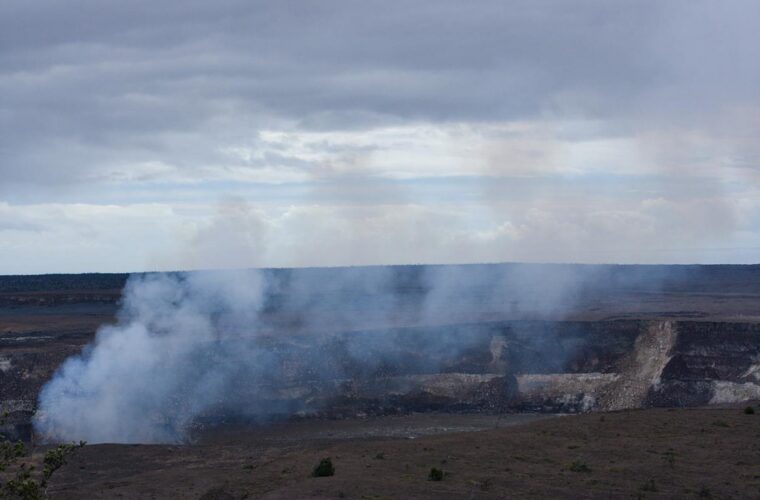
Photo: Gary Lee Todd, Ph.D. via Flickr (CC0 1.0 (Public Domain))
A Hawaii Volcanoes National Park Itinerary works best when you treat the park as a mountain to coast landscape, rather than a single volcanic crater. Kīlauea’s summit sits around 4,000 feet above sea level, while Chain of Craters Road descends nearly 3,700 feet through lava fields to the Pacific. Temperatures, rainfall, vegetation, and visibility can change dramatically during that descent.
The park occupies the southeastern side of Hawaiʻi Island and protects active volcanic terrain shaped primarily by Kīlauea and Mauna Loa. One day covers the summit highlights, two days allow time for the coast, and three days create room for longer hikes or the remote Kahuku section. Active lava is never guaranteed, so the itinerary must work even when no eruption is visible.
How to Plan 1, 2, or 3 Days in Hawaii Volcanoes National Park
The most efficient route begins around Kīlauea’s summit, where the visitor center, crater overlooks, steam vents, rain forest trails, and the Kīlauea Iki crater sit close together. Chain of Craters Road belongs on a separate half day or full day because its overlooks and short walks can easily turn the roughly 19 mile descent into a three to five hour outing.
The route logic that prevents backtracking
Spend your first morning on the summit trails before clouds and rain become more likely. Continue to overlooks and thermal features in the afternoon, then return after dark only if volcanic activity or clear skies justify another visit. On a second day, follow Chain of Craters Road downhill and make stops in descending order. A third day is best reserved for a longer hike, Mauna Loa Road, or Kahuku, rather than repeating the crater rim circuit.
| Day | Main stops | Primary highlight | Typical driving | Where to sleep |
|---|---|---|---|---|
| 1 | Kīlauea summit, Kīlauea Iki, Nāhuku, Uēkahuna | Crater geology and rain forest | Mostly 5 to 15 minutes between stops | Volcano area or Hilo |
| 2 | Chain of Craters Road, Puʻuloa Petroglyphs, Hōlei Sea Arch area | Lava flows from summit to coast | About 45 minutes each way without stops | Volcano area or Hilo |
| 3 | Mauna Loa Road, Kipukapuaulu, Kahuku, or a longer summit hike | Dry forest, older lava, and fewer visitors | Varies by selected route | Volcano area, Hilo, or onward around the island |
What each trip length realistically allows
With one day, prioritize Kīlauea Iki, the summit overlooks, steam vents, and a short portion of Chain of Craters Road only if daylight remains. Two days are substantially better because the coastal road receives enough time for petroglyphs and lava field walks. Three days suit hikers and travelers interested in the park’s ecological contrasts, including native forest growing on lava far older than the stark twentieth century flows near Kīlauea.
Arrival, supplies, and changing volcanic conditions
Volcano village is the closest practical base, a few minutes from the main entrance. Hilo lies roughly 30 miles northeast and usually requires about 45 minutes of driving. The Kona coast is much farther away, making a day trip possible but tiring, especially if the plan includes sunrise, evening eruption viewing, or a full descent to the coast.
Fuel, food, and mobile service
Fill the tank and buy substantial food before entering the park. Services become sparse along Chain of Craters Road, and the return climb uses more fuel than the downhill drive suggests. Pack lunch, at least two liters of water per person for a moderate hiking day, and extra water for exposed coastal walks. Mobile reception is inconsistent around forested trails, lava fields, and the lower coastal road, so download maps before leaving Hilo, Kona, or your accommodation.
- Carry a rain shell even when the Hilo forecast looks dry.
- Bring a warm layer for the 4,000 foot summit, especially before sunrise or after sunset.
- Use closed shoes with firm soles because young lava has sharp, uneven edges.
- Pack sun protection for Chain of Craters Road, where shade is limited.
- Keep a flashlight or headlamp available for dark parking areas and lava tube visits.
Check eruption status before choosing your stops
Kīlauea can shift from quiet degassing to eruptive activity, and closures may follow earthquakes, sulfur dioxide emissions, wildfire, road damage, or unstable crater edges. Check alerts, eruption viewing guidance, entrance information, and trail access on the official park site before departure. Our May 2026 park events and updates page also provides useful context for travelers visiting during that period.
Volcanic gas deserves special attention
Trade winds usually carry volcanic haze southwest, but wind shifts can move sulfur dioxide and fine particles across overlooks and roads. People with asthma, heart conditions, or respiratory sensitivity should avoid lingering where fumes are noticeable. Leave an area if breathing becomes uncomfortable, and never cross barriers to obtain a clearer view. Crater rims can be fractured, undercut, and unstable well beyond the visible edge.
Day one around Kīlauea’s summit
Begin near the visitor center and use current ranger information to decide the precise order of overlooks. The core plan combines the Kīlauea Iki Trail with nearby Nāhuku, followed by summit viewpoints and steam vents. Allow six to eight hours if hiking the full loop and stopping frequently for geology, birdlife, and changing crater views.
Morning hike through Kīlauea Iki
The Kīlauea Iki Trail forms a loop of roughly 3.3 miles and drops about 400 feet from rain forest to the floor of the crater created by the 1959 eruption. Walking counterclockwise usually places the steeper descent earlier, although either direction works. Expect roots, rock steps, wet foliage, and slick sections near the rim. The exposed crater floor can become hot by midday, which makes an early start more comfortable.
On the crater floor, the surface changes from damp forest soil to hard, rippled lava. Steam slips from cracks after rain, while the cliff walls rise around the broad basin and mute traffic noise from the rim. The crossing feels longer than it appears from above because the scale is difficult to judge. Small stacked rock markers identify the route across terrain with few conventional trail edges.
Add Nāhuku when access allows
Nāhuku, also called Thurston Lava Tube, formed when the exterior of a lava flow cooled while molten rock continued moving inside. After the flow drained, it left a walkable tunnel beneath dense vegetation. The approach is short but includes steps and damp pavement. Visit directly before or after Kīlauea Iki because the two sites share the same forested area and parking can become congested later in the morning.
Afternoon overlooks and thermal features
Continue toward Kīlauea’s summit overlooks after lunch. Uēkahuna provides broad views into the caldera and across toward Halemaʻumaʻu, the collapse crater that expanded dramatically during the 2018 summit events. Kīlauea Overlook offers another useful perspective on the caldera’s scale. Visibility changes quickly as clouds move across the summit, so stop when the crater is clear rather than assuming conditions will improve later.
Steam Vents and Sulphur Banks
At Steam Vents, groundwater descends through cracks, meets hot rock, and returns as vapor. Nearby Sulphur Banks, known as Haʻakulamanu, reveal a different process: volcanic gases deposit yellow sulfur crystals and alter the surrounding rock into pale clays. The area also supports native ʻōhiʻa lehua and other plants adapted to acidic, mineral rich ground. Remain on established paths because crusts can conceal hot or weakened surfaces.
Day two from the summit to the Pacific
Allow at least five hours for Chain of Craters Road, including the return climb. The road crosses lava from numerous eruptions, with signed pullouts revealing how Kīlauea’s East Rift Zone has repeatedly covered forest and pavement. Elevation falls steadily toward the coast, so temperatures commonly rise while shade and rainfall decrease. Carry lunch and water from the summit area because the lower road has no commercial services.
Crater overlooks and younger lava flows
Stop first at overlooks around Lua Manu, Pauahi, and other pit craters associated with the rift zone. Farther down, the landscape opens into broad fields from twentieth century eruptions. Look for differences in texture: smooth, folded pāhoehoe formed from fluid lava, while jagged ʻaʻā developed as cooler, more viscous flows broke apart. Both surfaces can remain sharp decades after an eruption.
Puʻuloa Petroglyphs and the coastal plain
The Puʻuloa Petroglyphs trail covers approximately 1.4 miles round trip across exposed lava. A raised boardwalk protects thousands of carved forms, including cup shaped depressions connected with Native Hawaiian cultural practices. Start only if everyone has water, sun protection, and footwear suited to uneven rock. Heat radiating from black lava makes this walk considerably harder at midday than its distance suggests.
The road’s final coastal stops
Continue toward the road’s end for views along cliffs built by successive lava flows entering the ocean. Strong surf, unstable edges, and loose rock make barriers important here. The drive back to the summit gains nearly 3,700 feet, so leave enough daylight for the climb and any viewpoints skipped during the descent.
Choosing the best third day
A third day should add a landscape absent from the first two days. Select one main excursion rather than combining distant corners of the park. Kipukapuaulu and Mauna Loa Road work well together near the summit, while Kahuku requires a separate drive along Highway 11. Longer crater hikes suit experienced walkers who have already assessed weather, gas, and trail conditions.
Native forest along Mauna Loa Road
Kipukapuaulu is an approximately 1.2 mile loop through a kīpuka, an island of older ground surrounded by younger lava. Its relatively deep soil supports native forest and birds that struggle in fragmented habitat elsewhere. Continue up Mauna Loa Road for changing views across Kīlauea, but remember that cloud can obscure the summit during the afternoon.
Kahuku’s contrasting terrain
Kahuku lies roughly 40 road miles southwest of the main entrance and protects former ranchland, native forest, cinder features, and lava from Mauna Loa. The higher slopes are cooler than the coastal highway. This choice works best for travelers continuing toward South Point or Kona, since returning to Hilo adds considerable backtracking.
- Choose Kipukapuaulu for a short walk focused on native ecology.
- Choose Mauna Loa Road for elevation, open views, and cooler conditions.
- Choose Kahuku for fewer people and a separate Mauna Loa landscape.
- Choose a longer summit hike only with adequate water, daylight, and recent trail information.
Adjusting the plan for weather and daylight
Hawaiʻi Volcanoes National Park remains workable throughout the year, but daily weather matters more than the calendar. Trade winds bring frequent mist and rain to the summit, while the coast can remain hot and dry. If clouds cover the caldera, hike in the forest first and revisit the overlooks later. During heavy rain, prioritize paved viewpoints and avoid slick crater descents.
| Conditions | Best adjustment | Main concern |
|---|---|---|
| Wet summit morning | Visit Nāhuku and thermal features, then reassess overlooks | Slick roots and reduced crater visibility |
| Hot, clear day | Walk Puʻuloa early and save driving stops for midday | Heat exposure on black lava |
| Strong coastal wind | Limit cliffside stops and remain behind barriers | Unstable footing and windblown debris |
| Cold summit evening | Add insulating layers before waiting at overlooks | Rapid cooling near 4,000 feet |
Plan around rain rather than fearing it
Brief showers often pass quickly, and wet weather intensifies the green color of the summit rain forest. Persistent rain changes the calculation because Kīlauea Iki’s roots and rock steps become slippery. Keep the Hawaii Volcanoes National Park Itinerary flexible enough to exchange the coastal and summit days when one zone has clearly better conditions.
Frequently Asked Questions
How many days do you need?
Two days provide the best balance: one for Kīlauea’s summit and one for Chain of Craters Road. Add a third day for Kahuku, native forest, or a longer hike.
Can children complete Kīlauea Iki?
Active children accustomed to hiking can often manage the 3.3 mile loop, but the descent, exposed crater floor, and climb require steady footing. Families needing a shorter outing can view the crater from the rim and visit Nāhuku.
Are dogs allowed on park trails?
Pets are restricted largely to specified developed areas and must remain controlled. Most backcountry trails and sensitive natural areas do not permit dogs, so plan pet care before a hiking day.
Can you visit the summit and coast in one day?
Yes, but the schedule will be compressed. Start early, complete one principal summit walk, then reserve the afternoon for Chain of Craters Road and its highest priority stops.
Is nighttime volcano viewing guaranteed?
No. Eruptions can pause or end with little warning, and clouds or volcanic gas can obscure active areas. The summit remains extremely dark after sunset, so carry a headlamp and stay on open paths.
Build the itinerary around one strong experience each day
A successful visit pairs realistic driving with enough time on foot to understand the landscape. Day one explains Kīlauea through its caldera, rain forest, lava tube, and 1959 crater. Day two follows lava toward the Pacific. Day three adds either Mauna Loa’s forests and slopes or the quieter Kahuku district.
Keep the order flexible when rain, gas, or volcanic activity changes the day. With water, layers, downloaded maps, and an early start, this Hawaii Volcanoes National Park Itinerary covers the park’s major geological and ecological zones without turning the visit into a rushed series of parking stops.
Want to keep exploring? Browse all our Hawaii Volcanoes guides and articles for more trip-planning tips and ideas.
Gear & Essentials
Tell us about your trip and we will add what else you will want:
The basics
Worth having in the car whatever the park.
For this trip
As an Amazon Associate we earn from qualifying purchases, at no extra cost to you.