Hawaii Volcanoes National Park: The Perfect 3-Day Itinerary
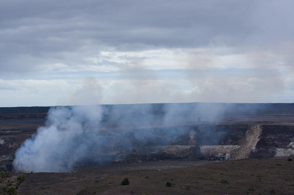
Photo: Milo & Silvia in the world via Flickr (CC BY-SA 2.0)
At Hawaii Volcanoes National Park, dawn at Kīlauea Overlook arrives with cool mist moving across the caldera and steam lifting from fractures below the rim. Underfoot, crushed basalt shifts against the pavement, while wind carries the faint mineral smell of volcanic gases. The opposite wall lies roughly two miles away, giving Halemaʻumaʻu and the wider summit collapse a scale that photographs rarely convey.
Three days allow time for Kīlauea’s summit, the descent from rainforest to coast on Chain of Craters Road, and the park’s quieter Kahuku district. Our itinerary uses one base near Volcano, minimizing packing and keeping the first two mornings close to popular trails. Eruption activity, volcanic gases, weather, and road closures can change the sequence, but the geographic logic remains useful under most conditions.
How the perfect 3-day Hawaii Volcanoes National Park route fits together
Hawaii Volcanoes National Park protects landscapes on Kīlauea and Mauna Loa, two active shield volcanoes built by repeated flows of fluid basalt. Elevation ranges from sea level to the 13,681 foot summit of Mauna Loa. Most visitor facilities and heavily used trails sit around Kīlauea’s summit, approximately 4,000 feet above sea level, where temperatures can be 15 to 25 degrees cooler than on the coast.
The route begins around the summit because this is where orientation matters most. Day two follows lava flows toward the ocean, tracing an ecological transition from wet ʻōhiʻa forest to exposed coastal basalt. Day three heads southwest on Highway 11 to Kahuku, a former ranch landscape covering part of Mauna Loa’s enormous flank. Keeping these areas on separate days prevents rushed hikes and repeated driving.
Hawaii Volcanoes National Park: the perfect 3-day itinerary at a glance
| Day | Primary stops | Main highlight | Driving | Overnight |
|---|---|---|---|---|
| 1 | Kīlauea Visitor Center area, Haʻakulamanu, Kīlauea Iki, Nāhuku | Summit geology and rainforest trails | Short transfers, generally 5 to 15 minutes | Volcano area |
| 2 | Chain of Craters Road, Puʻuloa Petroglyphs, coastal viewpoints | Young lava flows and the park’s sea level coast | About 40 minutes each way without stops | Volcano area |
| 3 | Kahuku district and trails on Mauna Loa | Pastoral history, cinder cones, and older lava landscapes | About 50 to 60 minutes each way | Volcano area or continue around the island |
Why this order works
The summit day requires the least driving and provides the clearest introduction to calderas, pit craters, rift zones, and volcanic hazards. It also places Kīlauea Iki early in the trip, when legs are fresh. That 3.3 mile loop descends roughly 400 feet through rainforest to a solidified lava lake created by the 1959 eruption.
Chain of Craters Road belongs on its own day because the 18.8 mile descent invites frequent stops. Overlooks reveal pit craters and broad pāhoehoe flows, while the temperature rises steadily toward the coast. Kahuku then adds a contrasting view of volcanism. Its grasslands, ranch traces, forest patches, and Mauna Loa flows feel physically and historically separate from Kīlauea’s busy summit.
Logistics to settle before entering Hawaii Volcanoes National Park
The community of Volcano is the most efficient base for this plan. Lodging consists primarily of small inns, vacation rentals, cabins, and limited accommodation inside or near the park. Hilo is roughly 30 miles northeast and has a broader range of groceries and lodging, but commuting from there adds close to an hour each morning in ordinary conditions. Staying near Volcano also makes it easier to revisit an overlook if clouds obscure the caldera.
There is no dependable reason to count on fuel, a full meal, or strong mobile service once inside the park. Fill the tank and buy breakfast, lunch, and water before beginning each day. Entrance charges, operating days, eruption viewing rules, trail closures, and services can change, so confirm current details on the official park site. Our May 2026 park events and updates page is also useful for trip specific programming and notices.
What to carry each day
Conditions around Kīlauea can shift between sun, wind, drizzle, and dense fog within an hour. Coastal stops are hotter and much more exposed, while Kahuku has limited shade on several routes. Pack for each microclimate rather than dressing for the temperature at your hotel.
- Rain shell and warm layer: Summit temperatures often feel cold after sunset or in trade wind showers.
- At least two liters of water per person: Carry more for Chain of Craters Road and longer Kahuku walks.
- Sturdy walking shoes: Fresh ʻaʻā lava is sharp, loose, and capable of cutting lightweight footwear.
- Sun protection: Coastal lava fields provide almost no natural cover.
- Food for a full day: Pack food securely and never feed nēnē or other wildlife.
- Offline map: Download navigation before leaving Volcano or Hilo.
Seasonal adjustments
Trade wind showers are common around the summit throughout the year, with wetter conditions generally favored during winter. Summer often brings somewhat steadier hiking weather, but exposed lava remains hot in direct sun. Heavy rain can make forest steps slippery and obscure crater views. Begin with Kīlauea Iki during a clear morning, then move indoor orientation or short roadside stops into periods of fog.
Volcanic air pollution, locally called vog, depends more on emissions and wind direction than season. People with asthma or cardiovascular conditions should avoid strenuous activity when sulfur dioxide is elevated. Move away from downwind overlooks if eyes sting, breathing becomes uncomfortable, or a sulfur odor grows stronger.
Day 1 in Hawaii Volcanoes National Park: Kīlauea summit
Plan to spend the first day within the summit district, where short drives connect overlooks, volcanic vents, rainforest, and the Kīlauea Iki crater. Arrive early enough to secure trailhead parking and allow six to eight hours for walking. The essential combination is Haʻakulamanu, Kīlauea Iki, and Nāhuku, with caldera overlooks added according to visibility and volcanic conditions.
Kīlauea’s summit changed dramatically during the 2018 collapse, when repeated earthquakes and subsidence enlarged Halemaʻumaʻu and lowered parts of the caldera floor. Later eruptions have rebuilt portions of that floor with fresh lava. Posted closure lines deserve a wide berth because apparently solid crater margins may be fractured, unstable, or exposed to concentrated volcanic gas.
Morning orientation and steam features
Begin near the visitor center area to review maps and ranger notices, then walk or drive toward Haʻakulamanu, also called Sulphur Banks. The roughly 1.2 mile route from the visitor center area crosses native forest before reaching steaming ground stained by sulfur minerals. Hydrogen sulfide and sulfur dioxide emerge along fractures, demonstrating how groundwater and volcanic heat interact beneath the summit.
Haʻakulamanu safety and ecology
Stay on the established boardwalk and trail. The crust beside it can conceal hot ground, and fumes collect unpredictably when wind drops. Look for ʻōhiʻa lehua, the foundational native tree of Hawaiian forests, and listen for the calls of ʻapapane feeding among its red blossoms. Clean mud and seeds from footwear before hiking to reduce the spread of invasive plants and pathogens that threaten ʻōhiʻa.
Kīlauea Iki and Nāhuku after midday
Allow two to three hours for the Kīlauea Iki loop. The rim passes through tree fern and ʻōhiʻa forest before descending steeply to the crater floor. Rock cairns mark the route across cracked lava, where steam may rise after rain. The climb back to the rim is sustained, so carry water and take extra care on wet stone steps.
Visit Nāhuku, the Thurston Lava Tube, before or after the crater hike depending on parking. The tube formed when the exterior of a lava stream cooled while molten rock continued flowing inside. Once the eruption’s supply diminished, the lava drained away and left a walkable conduit beneath the forest. The approach includes stairs and damp surfaces, making a small flashlight useful even when interior lighting is operating.
Day 2: Chain of Craters Road to the coast
Leave the summit after breakfast and descend Chain of Craters Road before midday heat builds on the lower lava fields. The road follows Kīlauea’s East Rift Zone, passing pit craters and flows from eruptions spanning centuries. Elevation drops approximately 3,700 feet between the summit and coast, so carry every layer from Day 1 but expect to finish in warmer, drier conditions. Allow most of the day even though the uninterrupted drive takes less than an hour.
Crater stops and Mauna Ulu
Lua Manu and Pauahi are worthwhile roadside stops for seeing how deep collapse pits intersect the rift zone. Farther down the road, Mauna Ulu records the 1969 to 1974 eruption, which produced lava fountains, a broad shield, and flows that crossed the roadway. A short walk from the Mauna Ulu parking area reveals lava trees and exposed pāhoehoe. Longer routes enter remote terrain, so save them for another trip unless everyone has backcountry navigation experience.
Where to prioritize your time
- Essential: Mauna Ulu, Kealakomo Overlook, Puʻuloa Petroglyphs, and the coastal road terminus.
- Optional: Brief crater pullouts when visibility is clear and parking is available.
- Skip when time is tight: Long rift zone hikes, which require more water and route planning than this itinerary allows.
Puʻuloa and the coastal cliffs
The Puʻuloa trail is approximately 1.4 miles round trip across exposed lava to a boardwalk protecting more than 23,000 recorded petroglyph images. Many are cup-shaped holes associated with family and ceremonial practices, while other carvings depict people, sails, and geometric forms. Continue afterward to the road’s coastal endpoint and the viewpoint for Hōlei Sea Arch. Eat a packed lunch in an appropriate pullout, then return uphill slowly enough for the engine and brakes to handle the sustained grade.
Day 3: Kahuku on Mauna Loa’s southwest flank
Kahuku adds open grassland, native forest, cinder features, and traces of ranching to the itinerary. The park acquired this former ranch landscape in 2003, greatly expanding protection on Mauna Loa’s southwest rift. Because the district lies southwest of the main Kīlauea entrance, begin with a full tank and plan one continuous outing. Return to the Volcano area for a final night, or continue toward South Kona if the next stage of your island trip heads west.
Choose one primary Kahuku trail
The 2.6 mile Palm Trail loop provides the best compact introduction. It crosses pasture, native vegetation, and lava from Mauna Loa’s 1868 eruption, with broad views toward the Kaʻū coast in clear weather. The roughly 2 mile Puʻu o Lokuana route is a shorter alternative focused on a cinder cone and the district’s ranch history. Both have exposed sections, uneven lava, and little dependable shade, so an early start remains valuable even when the summit district feels cool.
Understanding the managed landscape
Kahuku’s grasslands reflect generations of grazing as well as ongoing restoration. Crews remove invasive plants, protect native forest remnants, and sometimes use prescribed fire to reduce hazardous vegetation and support management goals. Our report on planned burning in the Kahuku-Pōhue section explains how that work can affect particular areas. Watch for nēnē along roads and maintain a generous distance if birds are feeding or walking nearby.
How to adapt the route without losing its structure
Keep each day tied to its geographic zone, then rearrange activities within that zone. Rain at Kīlauea Iki may justify visiting overlooks first, while coastal heat favors moving Puʻuloa earlier. Eruptions should be treated as changing natural events rather than guaranteed attractions. If viewing areas open, substitute them for an optional stop instead of abandoning the entire schedule. Never cross barriers or approach cracks to improve a view.
Weather based changes
| Condition | Best adjustment | Activity to reduce |
|---|---|---|
| Heavy summit rain | Use short overlooks, then hike when showers ease | Steep forest steps |
| Strong coastal heat | Reach Puʻuloa early and carry extra water | Midday lava field walking |
| Dense fog | Focus on forest, lava tubes, and close geology | Viewpoint waiting |
| Elevated volcanic gas | Move upwind and shorten exertion | Downwind crater overlooks |
A backup for a closed Kahuku day
If Kahuku access prevents Day 3 from working, stay in the summit district and combine Devastation Trail with the Puʻuhuluhulu area near Mauna Ulu. Devastation Trail crosses terrain buried by the 1959 Kīlauea Iki eruption, while Puʻuhuluhulu provides a forested cinder cone above younger lava. This substitution preserves the itinerary’s focus on volcanic processes without requiring a long drive or repeating the crater floor hike.
Completing your 3-day Hawaii Volcanoes National Park itinerary
This plan gives Hawaii Volcanoes National Park the time its scale demands. Day 1 explains the summit, Day 2 follows the East Rift Zone to sea level, and Day 3 shows how Mauna Loa’s lava, forests, ranching history, and modern restoration fit together. Using one base near Volcano keeps daily packing minimal and leaves room to respond to fog, rain, gas, or a changing eruption.
Prepare food, water, fuel, and offline directions before each departure, then protect flexibility for the conditions encountered that morning. Prioritize Kīlauea Iki, Mauna Ulu, Puʻuloa, and one Kahuku trail. Optional pullouts can fill clear hours, but they should never force hurried walking on sharp lava or a late return along an unfamiliar road.
Want to keep exploring? Browse all our Hawaii Volcanoes guides and articles for more trip-planning tips and ideas.
Gear & Essentials
Tell us about your trip and we will add what else you will want:
The basics
Worth having in the car whatever the park.
For this trip
Traveling with kids
Bringing a pet
RVing
Backcountry
Winter conditions
On the water
Photography
Accessibility
As an Amazon Associate we earn from qualifying purchases, at no extra cost to you.