The National Parks of Utah: A Guide to All 5
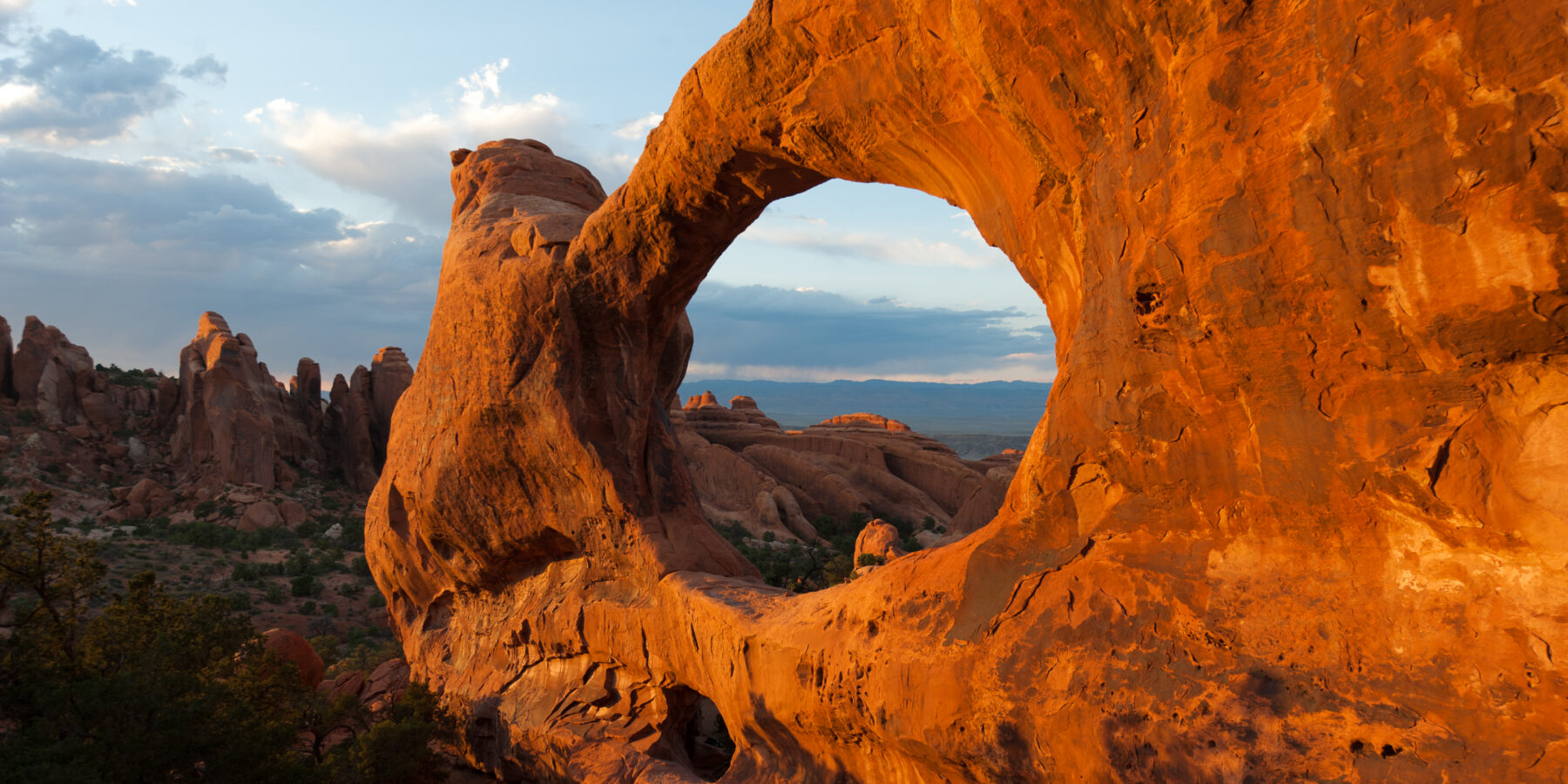
Our National Parks Utah Guide helps you choose among Arches, Bryce Canyon, Canyonlands, Capitol Reef, and Zion, then connect them without wasting days on backtracking. Allow at least seven days for a one-way highlights trip, although nine to twelve days gives each park enough time for a major hike, scenic drive, and sunset or sunrise.
The five parks form an arc across southern Utah. Zion and Bryce Canyon sit in the southwest, Capitol Reef occupies the center, and Arches and Canyonlands share the Moab area in the east. Their landscapes belong largely to the Colorado Plateau, but differences in elevation, rock layers, erosion, and river systems give each park a distinct character.
What separates Utah’s five national parks
All Five Parks at a Glance
Zion is built around a deep canyon and towering Navajo Sandstone walls. Bryce Canyon protects the world’s largest concentration of hoodoos, despite being a series of amphitheaters rather than a true canyon. Capitol Reef follows the Waterpocket Fold, a roughly 100-mile wrinkle in Earth’s crust. Arches contains more than 2,000 documented natural arches, while Canyonlands preserves an immense network of mesas and canyons carved by the Colorado and Green rivers.
| Park | Defining experience | Key elevation | Suggested first visit |
|---|---|---|---|
| Zion | Walking beneath sheer canyon walls | Zion Canyon is roughly 4,000 feet above sea level | 2 days |
| Bryce Canyon | Hiking among hoodoos below the rim | Rainbow Point reaches 9,115 feet | 1 day |
| Capitol Reef | Exploring the Waterpocket Fold and Fruita | Fruita sits near 5,500 feet | 1 to 2 days |
| Arches | Seeing freestanding arches and sandstone fins | Much of the park lies above 4,000 feet | 1 to 2 days |
| Canyonlands | Looking across river-cut mesas and canyon systems | Island in the Sky rises above 6,000 feet | 1 to 3 days |
One plateau, five different landscapes
The parks expose rock layers deposited in ancient seas, deserts, floodplains, and coastal environments. At Zion, the massive Navajo Sandstone records an enormous Jurassic dune field. Bryce’s softer Claron Formation erodes into fins and hoodoos through frost wedging and chemical weathering. Arches combines Entrada Sandstone with underground salt movement, which fractured the rock into narrow fins before erosion opened windows through them.
Capitol Reef’s defining structure formed when tectonic forces lifted rock layers along the Waterpocket Fold about 50 to 70 million years ago. Canyonlands reveals the erosional result of water working across a broad plateau. The Colorado and Green rivers divide it into Island in the Sky, The Needles, and The Maze, districts that are separated by deep canyons and require entirely different road approaches.
Building a practical route across southern Utah
The Five Parks in Geographic Order
The most efficient route runs west to east, or in reverse: Zion, Bryce Canyon, Capitol Reef, Arches, and Canyonlands. Zion to Bryce is approximately 86 road miles. Bryce to Capitol Reef is about 115 miles, while Capitol Reef to Moab is roughly 145 miles. Utah Scenic Byway 12 connects Bryce with the Capitol Reef region through Grand Staircase country, Boulder Mountain, and the hogback above Calf Creek.
Arches and Canyonlands appear close on a statewide map, but Canyonlands has no road connecting its districts. Island in the Sky is the logical pairing with Arches because both are reached from the Moab area. The Needles requires a separate approach from US 191 farther south. The Maze is a remote, high-clearance four-wheel-drive undertaking and does not fit comfortably into a standard five-park road trip.
Choosing gateways and overnight bases
Travelers flying into Las Vegas commonly begin with Zion, while Salt Lake City provides convenient access to central and eastern Utah. A one-way trip between those cities reduces backtracking. Springdale serves Zion Canyon, Bryce Canyon City and nearby communities cover Bryce, Torrey anchors Capitol Reef, and Moab works for Arches and Island in the Sky. Lodging becomes sparse between park gateways, so fuel up before crossing long stretches of Scenic Byway 12 or Interstate 70.
- Give Zion two nights if Angels Landing, The Narrows, or the West Rim is a priority.
- Use one night near Bryce for evening light and an early trail start.
- Spend one or two nights near Capitol Reef, especially if driving Cathedral Valley or hiking Cohab Canyon.
- Reserve at least three nights around Moab to divide Arches and Canyonlands into separate days.
Matching each park to its signature experience
Arches and Canyonlands reward different styles of exploration
Arches: concentrated formations and shorter approaches
Arches places many major formations along an 18-mile paved road. Delicate Arch requires a 3-mile round-trip hike across open slickrock, with little shade and an exposed final ledge. The Devils Garden trail reaches Landscape Arch after 1.9 miles round trip, while the full primitive loop covers roughly 7.8 miles. Windows, Double Arch, Balanced Rock, and Park Avenue accommodate shorter walks with high visual return.
Canyonlands: scale, overlooks, and longer backcountry routes
Island in the Sky is the easiest Canyonlands district for a first visit. Mesa Arch, Grand View Point, and Green River Overlook reveal different parts of the canyon system without long hikes. The Needles favors full-day routes such as Chesler Park, where striped Cedar Mesa Sandstone spires enclose grassy basins. River crossings do not connect these districts, so our team treats each as an independent destination.
Capitol Reef combines geology with human history
The paved scenic corridor enters the Waterpocket Fold from Fruita, a historic settlement established by Latter-day Saint pioneers in the 1880s. Orchards occupy the Fremont River floodplain beneath red cliffs, and petroglyph panels preserve evidence of the earlier Fremont culture. Cassidy Arch, reached by a roughly 3.4-mile round trip, overlooks Grand Wash. Capitol Gorge follows a narrower passage through tilted sandstone layers.
Bryce and Zion demand opposite pacing
Bryce is compact enough for one carefully planned day. The Navajo Loop and Queen’s Garden combination descends about 600 feet into the amphitheater over roughly 3 miles. Underfoot, pale gravel shifts between your boots as switchbacks drop through Wall Street. The air becomes cooler below the rim, voices echo between orange fins, and the hoodoos rise overhead rather than spreading below you as they do from Sunrise Point.
Zion needs more time because its principal experiences occupy separate corridors. Zion Canyon contains Angels Landing, Emerald Pools, and access to The Narrows. The east side holds Checkerboard Mesa and cross-bedded sandstone highlands, while Kolob Canyons protects quieter finger canyons in the park’s northwest corner. The elevation change between the canyon floor and high plateaus also creates sharper temperature and vegetation differences than many first-time visitors expect.
Season, heat, and reservation-sensitive planning
Choosing the Best Season
March through May brings mild desert hiking weather, but Bryce can retain snow while Zion Canyon feels like spring. Summer commonly pushes lower-elevation temperatures above 100°F, particularly around Moab and exposed parts of Canyonlands. July through September also brings monsoon storms, which can trigger flash floods in slot canyons and dry washes. October offers cooler hiking conditions, while winter brings solitude alongside snow, ice, and shorter daylight.
- Spring: Carry traction for icy Bryce trails and extra layers for high rims.
- Summer: Begin exposed hikes near sunrise and avoid enclosed canyons when storms threaten.
- Autumn: Expect cold mornings even when afternoons remain comfortable.
- Winter: Prepare for icy roads, shaded trail ice, and limited daylight between parks.
Permits, transportation, and changing operations
Some experiences require advance planning. Angels Landing uses a permit system, access to the Fiery Furnace is controlled, and Arches has periodically used timed entry during busy periods. Zion Canyon transportation, campground availability, entrance fees, road conditions, and backcountry permits can also affect an itinerary. Check every park’s official site before booking, with particular attention to permits, seasonal road closures, shuttle operations, and flash-flood forecasts.
Quieter districts that change the shape of the trip
The main scenic corridors provide a useful first look, but several secondary areas reveal how varied these parks are beyond their best-known overlooks. Adding one quieter district usually requires half a day, and sometimes a full day because access roads are slower. Choose one that complements your primary hikes rather than collecting extra stops. The following areas offer distinct geology, longer periods away from crowds, and enough substance to justify the detour.
Kolob Canyons, Fairyland, and the Needles
Kolob Canyons lies about 40 miles north of Zion Canyon by road. Its five-mile scenic road climbs past red finger canyons, while the Taylor Creek Trail covers roughly five miles round trip to Double Arch Alcove. At Bryce, the eight-mile Fairyland Loop descends among hoodoos north of the main amphitheater and accumulates about 1,900 feet of elevation change. In Canyonlands, short Needles walks such as Cave Spring and Pothole Point introduce the district without committing to a long backcountry day.
| Area | Time to allow | Road character | Best reason to go |
|---|---|---|---|
| Kolob Canyons | Half to full day | Paved scenic corridor | Finger canyons and quieter Zion hiking |
| Fairyland Loop | 4 to 5 hours | Paved trailhead access | A longer route below Bryce’s rim |
| Cathedral Valley | Full day | Remote unpaved loop | Monoliths and broad desert basins |
| Klondike Bluffs | Half day | Unpaved approach | Tower Arch and sandstone fins |
Capitol Reef’s backcountry and northern Arches
Capitol Reef’s Cathedral Valley loop runs approximately 58 miles through bentonite hills and around the Temples of the Sun and Moon. The route includes rough surfaces and a Fremont River ford, making vehicle capability and recent weather important. Farther south, the Burr Trail switchbacks cross the Waterpocket Fold near the park boundary. In Arches, the 2.6-mile Tower Arch Trail explores the Klondike Bluffs, where fractured sandstone fins stand beyond the park’s concentrated central corridor.
Planning each day around light and effort
A successful five-park itinerary alternates demanding hikes with scenic drives and short walks. Consecutive days on exposed slickrock can produce cumulative fatigue, especially when early starts reduce sleep. Pair Delicate Arch with roadside formations rather than the Devils Garden primitive loop. Follow a long Zion hike with Bryce overlooks or Capitol Reef’s Fruita district. This approach also preserves enough daylight for the drives between gateways, where wildlife and winding roads can slow evening travel.
Use sunrise and late afternoon selectively
Bryce’s amphitheater faces generally east, so early light reaches the hoodoos while the interior remains partly shadowed. Mesa Arch at Canyonlands frames morning light above Buck Canyon, although Grand View Point provides broader views throughout the day. Delicate Arch receives warmer light late in the afternoon, but its exposed approach can remain hot well into evening. At Zion, morning starts matter most for physical comfort on trails with prolonged sun exposure.
Match trail difficulty to the surface
Mileage alone understates effort in southern Utah. Bryce trails lose elevation at the beginning and demand the climb at the end. Slickrock routes at Arches require attention to cairns because repeated footsteps may leave no obvious tread. Canyonlands paths cross ledges, sand, and shallow drainages, while river hiking in The Narrows adds resistance and unstable footing. Build each day around these surface-specific demands:
- Carry trekking poles for river cobbles, loose descents, and icy shoulder-season trails.
- Use footwear with reliable traction for sandstone slabs and gravel-covered ledges.
- Download maps before entering districts with limited cellular coverage.
- Keep a headlamp accessible rather than buried beneath food or spare clothing.
Desert hazards that deserve route-level planning
Safety decisions begin before reaching a trailhead. Narrow canyons may collect runoff from storms many miles upstream, and clear skies overhead do not eliminate flood danger. Open plateaus create the opposite problem, with intense sun, reflected heat, and few places to shelter. Our National Parks Utah Guide recommends checking weather for the entire drainage, identifying turnaround points, and carrying enough water to handle an unexpectedly slow return.
Heat, altitude, and fast-changing weather
A gallon of water per person per day is a practical baseline for strenuous warm-weather travel, with additional capacity for remote drives. Electrolytes and salty food help replace losses during sustained sweating. Bryce’s rim exceeds 8,000 feet in many places, so visitors arriving from low elevations may notice heavier breathing and faster fatigue. Lightning also presents a serious risk on exposed rims and mesas. Descend from overlooks when thunder becomes audible rather than waiting for rain.
Protecting fragile desert surfaces
Dark, knobby biological soil crust contains cyanobacteria, lichens, mosses, and fungi that stabilize loose ground and help retain moisture. A single footprint can damage growth that took decades to develop. Remain on established trails, slickrock, or sandy washes instead of cutting across crusted soil. In canyon bottoms, avoid touching petroglyphs or adding marks to sandstone. These practices protect archaeological context and prevent erosion from widening informal paths around popular formations.
Gear & Essentials
Tell us about your trip and we will add what else you will want:
The basics
Worth having in the car whatever the park.
For this trip
As an Amazon Associate we earn from qualifying purchases, at no extra cost to you.
Completing Your Utah Itinerary
The strongest itinerary assigns time according to landscape rather than treating all five parks equally. Zion benefits from multiple days and careful trail selection. Bryce delivers its defining experience through a rim view and one descent below it. Capitol Reef rewards travelers who combine the Waterpocket Fold with Fruita’s cultural landscape. Arches concentrates remarkable formations along one corridor, while Canyonlands requires choosing a district and accepting its immense scale.
Plan the route in geographic order, reserve demanding hikes for cooler hours, and leave room for one secondary district. Seven days covers the principal landmarks, while nine to twelve days supports longer walks and safer pacing. With realistic drive times, surface-specific gear, and respect for desert weather, the five parks become a coherent journey through the Colorado Plateau rather than a rushed series of roadside stops.