










Natural Bridge
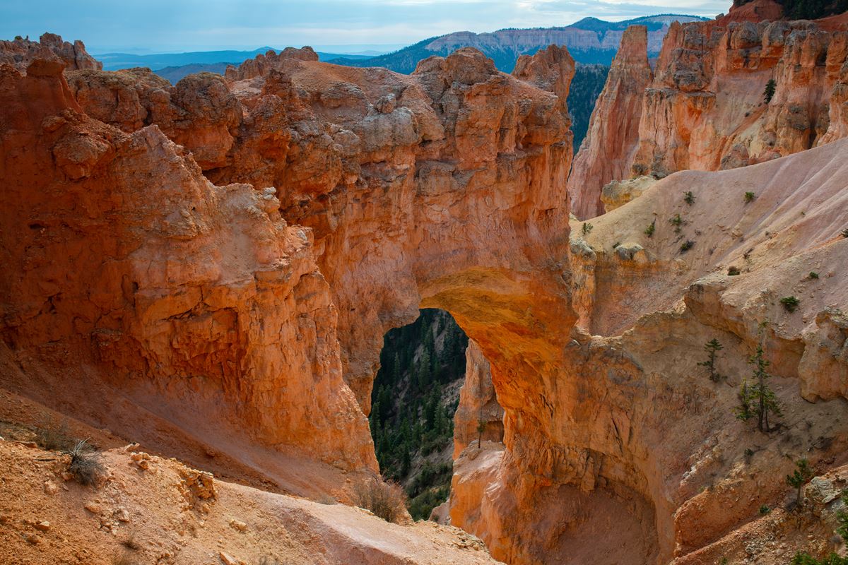
| Type | Point of Interest |
|---|---|
| Elevation | about 7,550 ft |
At a glance
- Place type: Point of Interest
- Area: Bryce Canyon
- Elevation: About 7,550 feet
- Location: Mile 12.25 of the 18 mile Southern Scenic Drive
- Significance: One of 9 viewpoints along the drive
- Accessibility: Wheelchair accessible
- Trails: No trails begin here
- Nearest listed junction: Agua Junction, about 0.9 miles away
- Visitor Center: About 9 miles away
Why visit
Natural Bridge provides a close view of a large natural window cut into the Pink Cliffs. Despite its name, the formation is an arch rather than a natural bridge.
The viewpoint also shows how water, ice, wind, and erosion shape the Paunsagunt Plateau. Visitors can examine the arch and see forested plateau edges, amphitheaters, and drainage patterns.
Getting there
Natural Bridge is at mile 12.25 of the 18 mile Southern Scenic Drive. It is one of 9 viewpoints along this route through Bryce Canyon National Park.
Agua Junction is about 0.9 miles away. The park’s main Visitor Center is about 9 miles away.
Bryce Canyon City and Tropic are each about 11 miles away in a straight line. Panguitch is about 23 miles away. These measurements are not driving distances.
The listed airports are Cedar City Airport (CDC) and St. George Regional Airport (SGU).
What to see and do
The main activity is viewing Natural Bridge and the surrounding landscape. No trails leave from this area, so plan this as a viewpoint rather than a trailhead.
Look east toward the arch and its amphitheater. Iron-oxide colors mark the lime-rich mudstones of Bryce Canyon’s Pink Cliffs. Rain and melting snow continue to weather these rocks.
Harder cap layers protect softer rock underneath, helping walls and fins persist while the plateau rim retreats. Water enters cracks within these fins. Freezing temperatures turn that water into expanding ice, which breaks rock from inside.
This repeated process opens windows in the rock. Natural Bridge is a particularly large example. Rain, wind, and ice continue to widen the opening.
To the north and south, the plateau’s eroded, forested edge has been carved into bowl-shaped amphitheaters. Rain and snowmelt drive this continuing change.
To the west, rolling ponderosa forest covers the Paunsagunt Plateau. Water has cut deeply into the plateau as it moves north toward Tropic Reservoir.
The plateau rises toward the south, influencing which direction water flows. Its edge marks a drainage divide between Nevada’s Great Basin and the Colorado River system.
History and nature
Natural Bridge’s name does not match its geological classification. A true natural bridge develops when a stream or river cuts through rock. This formation arose mainly through ice expanding inside deep cracks.
A durable rock layer shields the softer material below from faster erosion. Meanwhile, ice, rain, and wind enlarge the opening over time.
As the plateau edge retreated, it left a small gully below the arch. Rain and melting snow flow through that gully, now more than 125 feet beneath the opening.
The arch formed through the same broad sequence that creates Bryce Canyon’s hoodoos. Erosion first leaves walls or fins where resistant caprock slows the removal of softer layers.
Water then seeps into cracks in those fins. Overnight freezing expands the water into ice, prying the rock apart and opening windows.
Natural Bridge will not remain in its present form forever. Its caprock will eventually fall. Rock spires, called hoodoos, will remain on both sides of the former opening.
The surrounding landscape shows this process at a larger scale. Rain and snowmelt carve separate amphitheaters into the Pink Cliffs and the forested edge of the Paunsagunt Plateau.
When to go
Bryce Canyon National Park is open 24 hours a day, 365 days a year. Weather varies considerably because of the park’s high-elevation climate.
From October through May, temperatures drop below freezing on nearly every night. December through February usually bring the park’s coldest and snowiest conditions.
Heavy snow can still fall during storms in March and April. These storms may affect regional travel.
Summer daytime highs are generally in the 70s and 80s F. Afternoon thunderstorms are common during July and August.
Accessibility
Natural Bridge is listed as wheelchair accessible. It is a scenic roadside point of interest rather than a trailhead.
No trails depart from the viewpoint. Check current conditions and accessibility notices on the park’s National Park Service website before visiting.
Fees and rules
Bryce Canyon National Park charges the following entrance fees:
- Private vehicle: $35
- Motorcycle: $30
- Per person: $20
- Nonresident: $100
The park remains open throughout the year and at all hours. Access or travel conditions may still change with weather, especially during snowy periods.
Follow posted rules at the viewpoint. Remain in designated visitor areas and leave the rock formation undisturbed.
Nearby trails and places
Agua Junction is the nearest listed place, about 0.9 miles away. The Visitor Center is about 9 miles away and serves as the park’s main visitor center.
Natural Bridge is one of 9 viewpoints on the Southern Scenic Drive. Its position at mile 12.25 places it along the drive’s 18 mile route.
No trails begin at Natural Bridge. Visitors seeking trail information can check current park materials and ask at the Visitor Center.
Nearby gateway communities include Bryce Canyon City and Tropic, each about 11 miles away. Panguitch is about 23 miles away. All are straight-line measurements rather than road distances.
Before you go
Check current conditions, weather, road information, and park alerts on the National Park Service website. Snow and spring storms can affect travel, while summer afternoons can bring thunderstorms.
Carry water and pack layers for changing conditions. Follow posted rules and leave no trace. Remember that Natural Bridge is a viewpoint without departing trails.
Questions
Is Natural Bridge in Bryce Canyon a real natural bridge?
No. It is a natural arch, or window, formed mainly by ice expanding within cracks.
Where is Natural Bridge in Bryce Canyon National Park?
It is at mile 12.25 of the 18 mile Southern Scenic Drive.
Are there trails at Natural Bridge?
No trails depart from the Natural Bridge area.
Is Natural Bridge wheelchair accessible?
Yes. Natural Bridge is listed as wheelchair accessible.
How high is Natural Bridge?
The viewpoint is at about 7,550 feet in elevation.
How was Natural Bridge formed?
Water entered cracks, froze, expanded, and broke rock apart. Rain, wind, and erosion also helped enlarge the window.
What will eventually happen to Natural Bridge?
Its caprock will collapse, leaving hoodoos on both sides of the former opening.
Is Bryce Canyon National Park open year-round?
Yes. The park is open 24 hours a day, 365 days a year.
Nearby
Places
- Agua Junction
On the map
6 trails13 places to see7 visitor services
Facts on this page draw on the National Park Service: Natural Bridge (nps.gov)