










Rainbow Point
| Type | Overlook |
|---|---|
| Elevation | about 9,090 ft |
| Facilities | Restrooms · Parking · Picnic area |
At a glance
- Place: Rainbow Point
- Type: Overlook
- Location: Southern end of the main park road in the Bryce Canyon area
- Elevation: About 9,090 feet
- Significance: Rainbow Point and Yovimpa Point are the park’s highest viewpoints
- Facilities: Parking, restrooms, picnic area, bicycle rack, picnic tables, recycling, and trash receptacles
- Accessibility: Wheelchair accessible
- Information: Historical and interpretive exhibits are available
- Park hours: Open 24 hours a day, 365 days a year
Why visit
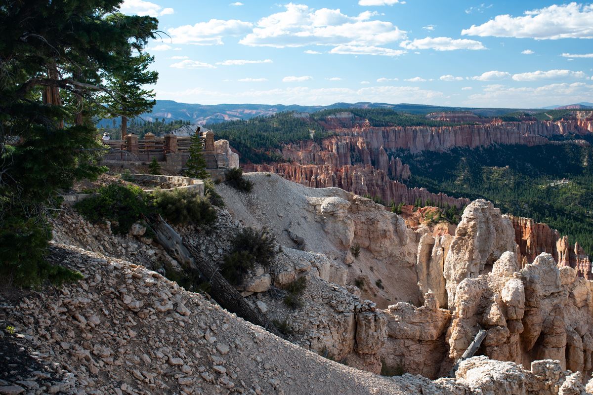
Rainbow Point overlooks the eroded edge of the Paunsaugunt Plateau from one of Bryce Canyon National Park’s highest viewpoints. Its position reveals cliffs, amphitheaters, river valleys, plateaus, and distant mountains.
The overlook also illustrates how elevation, erosion, and watersheds shape the region. Water from different parts of the plateau eventually flows toward either the Colorado River or Nevada’s Great Basin desert.
Rainbow Point provides access to the Bristlecone Loop, Riggs Spring Loop, and Under-the-Rim Trail. Yovimpa Point offers complementary views to the south.
Getting there
Rainbow Point is at the southern end of Bryce Canyon National Park’s main road. Rainbow Point Parking is about 0.1 miles away.
The park’s Visitor Center is about 12 miles away. Tropic, Utah, is about 13 miles away in a straight line. Bryce Canyon City is about 14 miles away, and Panguitch is about 26 miles away.
Travelers arriving by air can use Cedar City Airport or St. George Regional Airport. The provided information does not include road distances or travel times from these airports.
What to see and do
Look north across the worn edge of the Paunsaugunt Plateau. Rain and melting snow have cut bowl-shaped amphitheaters into the plateau. Their runoff reaches the Paria River and then the Colorado River.
The Markagunt Plateau lies northwest, while the Paunsaugunt Plateau extends north. The Tushar Mountains and Sevier Plateau, also called the Black Mountains, are visible beyond them. Volcanic activity connected with the Colorado Plateau’s uplift formed these features.
Eastward, Bryce Canyon’s Pink Cliffs contain lime-rich mudstones colored by iron oxide. Below them, the Paria River valley exposes marine shale within the Grey Cliffs. White Cliffs sandstone appears farther south.
Across the valley, the Pink Cliffs rise along Table Cliff Plateau to about 10,000 feet. Their height and color help distinguish them from the lower formations.
To the west, views extend across the Paunsaugunt Plateau toward the Black Mountains and more distant Tushar Mountains. Water on the plateau’s forested top drains west and north through the Sevier River toward Nevada.
The plateau edge forms a watershed divide. One side drains into the Colorado River system, while the other sends water toward the Great Basin desert.
For southern views, cross the parking area to Yovimpa Point or follow the Bristlecone Loop Trail. A short path beside the plateau edge leads west toward the loop and longer backcountry routes.
History and nature
Tectonic uplift raised this landscape from sea level during the last 20 million years. Tributaries of the Paria and Colorado rivers later cut into the elevated terrain.
The land tilted as it rose. Consequently, the southern park area stands about 1,000 feet above the area around the Visitor Center to the north.
Erosion has acted around Rainbow Point longer than at the Bryce Amphitheater. Undercut, nearly vertical cliffs therefore dominate much of the view along the Paunsaugunt Plateau’s edge.
Rain and snowmelt continue shaping the amphitheaters and feeding regional drainage systems. The exposed rock layers also record different environments, including marine shale and sandstone.
When to go
Bryce Canyon National Park is open throughout the year. Its high-elevation weather can change considerably during autumn, winter, and spring.
From October through May, nighttime temperatures usually drop below freezing. December through February generally bring the park’s coldest weather and most snow.
March and April storms can still deliver heavy snow and affect regional travel. Check current conditions before visiting during these months.
Summer daytime highs are generally in the 70s or 80s Fahrenheit. Afternoon thunderstorms commonly occur in July and August.
Accessibility
Rainbow Point is listed as wheelchair accessible. Parking and restrooms are available, with both located about 0.1 miles from the overlook.
The site also has picnic tables, recycling, trash receptacles, a bicycle rack, and historical or interpretive information. Specific accessibility details for trails are not provided.
Fees and rules
Bryce Canyon National Park charges these entrance fees:
- Private vehicle: $35
- Motorcycle: $30
- Per person: $20
- Nonresident: $100
The park is open 24 hours a day on all 365 days of the year. Follow posted rules and leave no trace.
Nearby trails and places
Rainbow Overlook Shelter is at Rainbow Point. Rainbow Dry Head North and Rainbow Dry Head South restrooms are each about 0.1 miles away.
Rainbow Point Parking, the picnic area, Bristlecone Loop Trailhead, and Yovimpa Point Trailhead are also about 0.1 miles away.
The Bristlecone Loop is about 1.0 mile and rated easy. It can be reached by a short path running west along the plateau edge.
The Riggs Spring Loop is a backcountry route described by the National Park Service as about 8.8 miles. The mapped nearby trail listing identifies about 1.5 miles and places it about 0.2 miles away.
Under-the-Rim Trail is about 23 miles. The Under-the-Rim–Riggs Spring Junction is about 0.2 miles from Rainbow Point.
The Bristlecone–Riggs Spring junctions on both the east and west sides are about 0.2 miles away. These junctions connect the overlook area with the surrounding trail network.
Before you go
Check current weather, road conditions, trail conditions, and park alerts on the National Park Service website. Snow can affect regional travel, especially from winter into spring.
Carry water and pack layers for the high-elevation climate. Be prepared for freezing nights from October through May and afternoon thunderstorms during July and August.
Use designated parking, restrooms, picnic facilities, recycling, and trash receptacles. Follow posted rules and leave no trace.
Questions
Where is Rainbow Point in Bryce Canyon National Park?
It is at the southern end of the park’s main road in the Bryce Canyon area.
How high is Rainbow Point?
Rainbow Point is at about 9,090 feet and is among the park’s highest viewpoints.
What can be seen from Rainbow Point?
Views include the Paunsaugunt and Markagunt plateaus, Pink Cliffs, Paria River valley, Black Mountains, Tushar Mountains, and Sevier Plateau.
Are there restrooms and parking at Rainbow Point?
Yes. Parking and restrooms are available about 0.1 miles from the overlook.
Is Rainbow Point wheelchair accessible?
Yes. Rainbow Point is listed as wheelchair accessible.
Which trails are near Rainbow Point?
Nearby routes include Bristlecone Loop, Riggs Spring Loop, and Under-the-Rim Trail.
What is the weather like at Rainbow Point?
Nights often freeze from October through May. Winters are snowy, while July and August commonly have afternoon thunderstorms.
How much does it cost to enter Bryce Canyon National Park?
Fees are $35 per private vehicle, $30 per motorcycle, $20 per person, and $100 for a nonresident pass.
Nearby
Trails
Places
- Rainbow Overlook Shelter
- Rainbow Dry Head North
- Rainbow Dry Head South
- Rainbow Point Parking
- Bristlecone Loop Trailhead
- Picnic Area
- Yovimpa Point Trailhead
- Under-the-Rim – Riggs Spring Junction
On the map
3 trails12 places to see4 visitor services
Facts on this page draw on the National Park Service: Rainbow Point (nps.gov)