










Sunset Point
| Type | Overlook |
|---|---|
| Elevation | about 7,980 ft |
| Facilities | Restrooms · Parking · Shuttle stop · Drinking water |
At a glance
- Place type: Overlook
- Elevation: About 7,980 feet
- Location: Mile 2.25 of the 18 mile main park road
- Significance: One of 4 principal overlooks above the Bryce Amphitheater
- Facilities: Parking, restrooms, drinking water and a shuttle stop
- Other amenities: Bicycle rack, picnic table, interpretive exhibits, trailhead, trash receptacles and wheelchair access
- Visitor Center: About 1 mile away
- Park hours: Open 24 hours a day, 365 days a year
Why visit
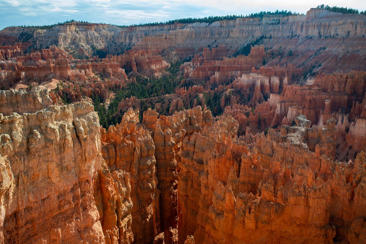
Sunset Point provides broad views across the Bryce Canyon Amphitheater. It is known for views of famous hoodoos and the varied colors of the surrounding cliffs.
Thor’s Hammer stands almost directly below the overlook. The Silent City forms a maze of rock formations farther south, beneath the rising rim toward Inspiration and Bryce Points.
The viewpoint also serves as a starting area for two popular walks. The Rim Trail follows the amphitheater’s edge, while the Navajo Loop Trail descends below the rim.
Getting there
Sunset Point is at mile 2.25 along the park’s 18 mile main road. Its parking area, comfort station and shuttle stop are each about 0.1 miles away.
The site has parking, a shuttle stop and a bicycle rack. The Visitor Center is about 1 mile away.
Bryce Canyon City, Utah, is about 4 miles away in a straight line. Tropic is about 5 miles away, and Panguitch is about 20 miles away.
The listed airports are Cedar City Airport (CDC) and St. George Regional Airport (SGU).
What to see and do
Look east across the amphitheater toward the Table Cliff plateau. Its notched southern end, called Powell Point, is 13 miles away and rises 2,000 feet above the overlook.
Navajo Mountain appears as a rounded dome about 80 miles away to the south. Inside the park, Sinking Ship’s tilted rock layers mark the Paunsaugunt fault.
To the north, Sunrise Point rises gradually along the rim. Boat Mesa extends beyond the ridgeline above the Queen’s Garden Trail’s gradual descent.
Thor’s Hammer is directly below the viewpoint. The Two Bridges side of the Navajo Loop provides another view of this well-known hoodoo.
Walk between Sunset Point and Sunrise Point on the Rim Trail. This popular section is about 0.5 miles, paved and has little elevation change. A typical hike takes 35 minutes.
The paved section permits leashed pets. It follows the rim above the Bryce Canyon Amphitheater, with views of hoodoos below.
The full Rim Trail is about 5.5 miles. It links Sunset Point with Sunrise and Fairyland Points to the north. It also connects with Inspiration and Bryce Points to the south.
The Navajo Loop Trail begins in the viewpoint area and descends into the Silent City. The Navajo Loop Upper Junction and trailhead are at Sunset Point.
History and nature
The cliffs expose rock from the Claron Formation. This formation consists mainly of limestone laid down about 50 million years ago beneath an extensive freshwater lake.
Geologists call that ancient body of water Lake Claron. Mineral content helps explain the distinct bands and patches of color visible from Sunset Point.
Iron oxides create reds, oranges and yellows in the cliffs’ lower half. Geologists refer to this portion as the Pink Member.
Manganese oxides produce areas of pink and purple. The transition from orange rock to white limestone indicates the start of the Upper Member.
The Upper Member contains purer limestone. Its white appearance results from having fewer mineral impurities.
The Paunsaugunt fault is visible through the tilted layers at Sinking Ship. Other named formations in the view include Thor’s Hammer, Silent City, Boat Mesa and Powell Point.
When to go
Bryce Canyon National Park remains open 24 hours a day throughout the year. The high-elevation climate brings substantial weather changes during autumn, winter and spring.
Temperatures usually drop below freezing nearly every night from October through May. December through February are generally the coldest and snowiest months.
March and April can bring heavy spring snow that affects regional travel. Check current conditions before traveling during these variable seasons.
Summer daytime highs are generally in the 70s–80s F. July and August frequently bring thunderstorms later in the day.
Accessibility
Sunset Point is designated wheelchair accessible. The site has accessible amenities, including a restroom, parking, drinking water, picnic tables and interpretive information.
The Rim Trail section from Sunset Point to Sunrise Point is paved. It has minimal elevation change and covers about 0.5 miles.
Current conditions can affect access. Review park alerts and posted information before visiting.
Fees and rules
Bryce Canyon National Park charges the following entrance fees:
- Private vehicle: $35
- Motorcycle: $30
- Per person: $20
- Nonresident: $100
Leashed pets are permitted on the paved Rim Trail section between Sunset Point and Sunrise Point. Follow posted rules throughout the viewpoint and trail areas.
Use the available trash receptacles and leave no trace. Stay on designated routes and protect the rock formations.
Nearby trails and places
Several services and landmarks are at Sunset Point. These include the Navajo Loop Upper Junction, drinking-water station, Navajo Loop trailhead and Thor’s Hammer Viewpoint.
Wall Street is about 0.1 miles away. The Sunset Point parking area, comfort station and shuttle stop are also about 0.1 miles away.
Western Cabin Parking Area West and Western Cabin Deluxe Quad are about 0.2 miles away.
Nearby mapped trails include:
- Rim Trail: About 0.1 miles away and about 0.5 miles as mapped by the National Park Service
- Queens Garden Trail: About 0.3 miles away and about 0.3 miles as mapped
- Navajo Loop Trail: About 0.4 miles away and about 1.3 miles as mapped
- Navajo Loop to Peekaboo Loop Connector Trail: About 0.4 miles away and about 0.3 miles as mapped
- Peekaboo Loop Trail: About 0.5 miles away and about 0.5 miles as mapped
- Horse Trail: About 0.5 miles away and about 1.4 miles as mapped
Before you go
Check current conditions and alerts on the park’s National Park Service website. Snow, freezing temperatures and spring storms can affect travel and access.
Carry water even though potable water is available at the viewpoint. Pack layers for changing high-elevation weather.
Storms often develop on summer afternoons during July and August. Follow posted rules, use designated paths and leave no trace.
Questions
Where is Sunset Point in Bryce Canyon National Park?
It is at mile 2.25 of the park’s 18 mile main road.
What can visitors see from Sunset Point?
Visitors can see hoodoos, Thor’s Hammer, Silent City, Sinking Ship, Table Cliff plateau, Powell Point, Boat Mesa and Navajo Mountain.
Is Sunset Point wheelchair accessible?
Yes. Sunset Point is designated wheelchair accessible, and the route toward Sunrise Point is paved with minimal elevation change.
Are there restrooms and drinking water at Sunset Point?
Yes. The viewpoint area has restrooms, potable drinking water, parking and a shuttle stop.
How long does the Sunset Point to Sunrise Point hike take?
The typical time is 35 minutes on about 0.5 miles of paved Rim Trail.
Are pets allowed at Sunset Point?
Leashed pets are permitted on the paved Rim Trail section between Sunset Point and Sunrise Point.
What trail descends from Sunset Point?
The Navajo Loop Trail descends from the viewpoint area into the Silent City.
Is Bryce Canyon National Park open year-round?
Yes. The park is open 24 hours a day, 365 days a year.
Nearby
Trails
Places
- Navajo Loop Upper Junction
- Water Station
- Navajo Loop Trailhead / Trail End
- Thor’s Hammer Viewpoint
- Sunset Point Parking Area RT 0918
- Sunset Point Comfort Station
- Shuttle Stop
- Wall Street
On the map
7 trails24 places to see9 visitor services
Facts on this page draw on the National Park Service: Sunset Point (nps.gov)