










Mohave Point
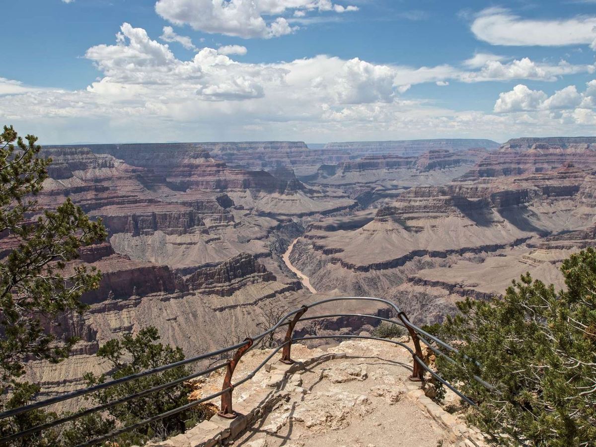
| Type | Viewpoint |
|---|---|
| Elevation | about 6,910 ft |
| Facilities | Parking · Shuttle stop · Picnic area |
At a glance
- Type: Viewpoint and scenic overlook
- Location: Hermit Road in the Grand Canyon area of the park
- Elevation: About 6,910 feet
- Best known for: Colorado River views and sunset watching
- Facilities: Shuttle stop, picnic area, and auto, bus, and RV parking
- Amenities: Picnic table, interpretive exhibits, and a designated scenic photo spot
- Visitor center: Grand Canyon Visitor Center, about 3 miles away
Why visit
Mohave Point provides a broad view into the Grand Canyon and down to the Colorado River. It is also a favored overlook for watching sunset.
From the viewpoint, visitors can identify several rapids and prominent formations with distinctive names. Interpretive information helps connect the visible landscape with names assigned by artists and photographers.
Getting there
Mohave Point is on Hermit Road in Grand Canyon National Park. The site has a shuttle stop and parking for automobiles, buses, and RVs. Mohave Point Parking is about 0.1 miles away.
Pullout Parking is about 0.2 miles away. The Grand Canyon Visitor Center is about 3 miles away.
Tusayan, Arizona, is about 7 miles away in a straight line. Williams is about 57 miles away, and Flagstaff is about 67 miles away. These figures are not driving distances.
Nearby airports include Flagstaff Pulliam Airport and Phoenix Sky Harbor International Airport.
The South Entrance and Desert View East Entrance remain open all day, every day. The South Entrance near Tusayan handles the most traffic.
Waits at the South Entrance can reach 2 hours between 9:30 a.m. and 4 p.m. Desert View East Entrance usually has shorter waits.
That entrance is 32 miles east of the village. Drivers reach it through Cameron using US 89, then travel west on SR 64.
What to see and do
Look deep into the canyon for views of the Colorado River. Salt Creek, Granite, and Hermit rapids are also visible from Mohave Point.
Below the overlook, a formation called “The Alligator” extends visually across the river toward the “Tower of Set.” Photographer Emery Kolb named The Alligator. Painter Thomas Moran named the Tower of Set.
The Horus and Osiris temples stand beside those formations. Look left for the “Tower of Ra” and right for “Isis Temple.”
The named formations invite visitors to look for recognizable shapes and personally meaningful features in the canyon. The site’s photo spot and interpretive exhibits support careful observation.
Sunset is a prominent reason to visit. The picnic table and picnic area also provide a place to pause near the overlook.
History and nature
Mohave Point’s interpretive story includes names associated with creative figures who studied the canyon landscape. Emery Kolb named The Alligator, while Thomas Moran named the Tower of Set.
Other visible features carry names from Egyptian mythology. These include the Horus and Osiris temples, Tower of Ra, and Isis Temple.
The overlook also reveals the Colorado River and 3 visible rapids: Salt Creek, Granite, and Hermit. The combination of river, rapids, and named formations defines the view.
Mohave Point sits at about 6,910 feet. Conditions here can differ greatly from those deep inside the canyon because the park spans a wide elevation range.
Grand Canyon elevations extend from about 2,500 feet at the bottom to about 8,400 feet on the North Rim. Specific conditions depend on location and season.
When to go
Mohave Point is particularly suited to sunset viewing. Arrive with enough time to identify the Colorado River, rapids, and named formations before daylight fades.
Winters are generally cold and snowy. Summers can bring periods of excessive heat. Temperatures within the canyon are usually 20 to 30 degrees warmer than temperatures along the rims.
Weather may change quickly. Check the forecast and current park conditions before visiting, especially when planning an evening stop.
Accessibility
Mohave Point has auto, bus, and RV parking, plus a park shuttle stop. Mohave Point Parking is about 0.1 miles from the named place.
A picnic table, interpretive information, and a scenic photo spot are available. The supplied park information does not provide details about grades, surfaces, or wheelchair access.
Fees and rules
Grand Canyon National Park entrance fees are $35 for a private vehicle and $30 for a motorcycle. The per-person entrance fee is $20. The listed nonresident fee is $100.
Entrance stations accept credit cards and America the Beautiful passes. Cash is not accepted.
Both the South Entrance and Desert View East Entrance operate all day, every day. Follow posted rules at the overlook and picnic area. Protect the site by leaving no trace.
Nearby trails and places
The Picnic Area is at Mohave Point. Mohave Point Parking is about 0.1 miles away, while Pullout Parking is about 0.2 miles away.
Hopi Point’s shuttle stop and Hopi Point 2 Parking are each about 0.6 miles away. A comfort station with restrooms is also about 0.6 miles away.
Hopi Point Parking and the Hopi Point viewpoint are each about 0.7 miles away. Powell Point’s shuttle stop is about 0.8 miles away. Salt Creek campsite is also about 0.8 miles away.
These distances identify nearby mapped places and do not establish walking routes. No trail details are provided for Mohave Point.
Before you go
Check the park’s National Park Service website for current conditions, alerts, shuttle information, and entrance updates. Review the weather forecast because conditions can change quickly.
Carry water and pack layers. Summer heat can be excessive, while winter conditions may be cold and snowy.
Plan around possible South Entrance congestion. Lines can be longest between 9:30 a.m. and 4 p.m., with waits reaching 2 hours.
Bring a credit card or an accepted America the Beautiful pass for entry. Cash is not currently accepted.
Follow posted rules, remain in designated visitor areas, and leave no trace. Use the available parking according to posted vehicle restrictions.
Questions
Where is Mohave Point in Grand Canyon National Park?
Mohave Point is a scenic overlook on Hermit Road in the Grand Canyon area of the park.
What can you see from Mohave Point?
Visitors can see the Colorado River, Salt Creek, Granite, and Hermit rapids, plus several named formations and temples.
Is Mohave Point good for sunset?
Yes. National Park Service information identifies Mohave Point as a notable place for watching sunset.
What named formations are visible from Mohave Point?
Visible features include The Alligator, Tower of Set, Horus and Osiris temples, Tower of Ra, and Isis Temple.
Does Mohave Point have parking and a shuttle stop?
Yes. It has a shuttle stop and parking for automobiles, buses, and RVs.
Are there picnic facilities at Mohave Point?
Yes. The site has a picnic area and picnic table.
How high is Mohave Point?
Mohave Point is at about 6,910 feet.
How much does it cost to enter Grand Canyon National Park?
Fees are $35 per private vehicle, $30 per motorcycle, $20 per person, and $100 for the listed nonresident fee.
Nearby
Places
- Picnic Area
- Mohave Point Parking
- Pullout Parking
- Hopi Point
- Hopi Point 2 Parking
- Comfort Station
- Hopi Point Parking
- Hopi Point
On the map
8 trails24 places to see8 visitor services
Facts on this page draw on the National Park Service: Mohave Point (nps.gov)