










Cap Rock Nature Trail
| Length | about 0.4 miles as mapped by NPS |
|---|---|
| Surface | Native |
| Open to | Hiking |
| Route | Loop |
| High point | about 4,310 ft |
| Low point | about 4,270 ft |
| Difficulty | Easy |
At a glance
- Distance: About 0.4 miles as mapped by the National Park Service
- Route: Loop ending where it starts
- Typical time: 15–45 minutes; the NPS activity estimate is 25 minutes
- Difficulty: Easy
- Surface: Native dirt and gravel, primarily hard-packed sand
- Average width: 36 inches
- Elevation: About 4,270–about 4,310 feet
- Elevation change: About 30 feet of climbing and 30 feet of descent along the mapped loop
- Use: Hiking
- Area: Park Boulevard in central Joshua Tree National Park
- Seasons: Winter, spring, summer and fall
- Time of day: Dawn, day and dusk
Why hike it
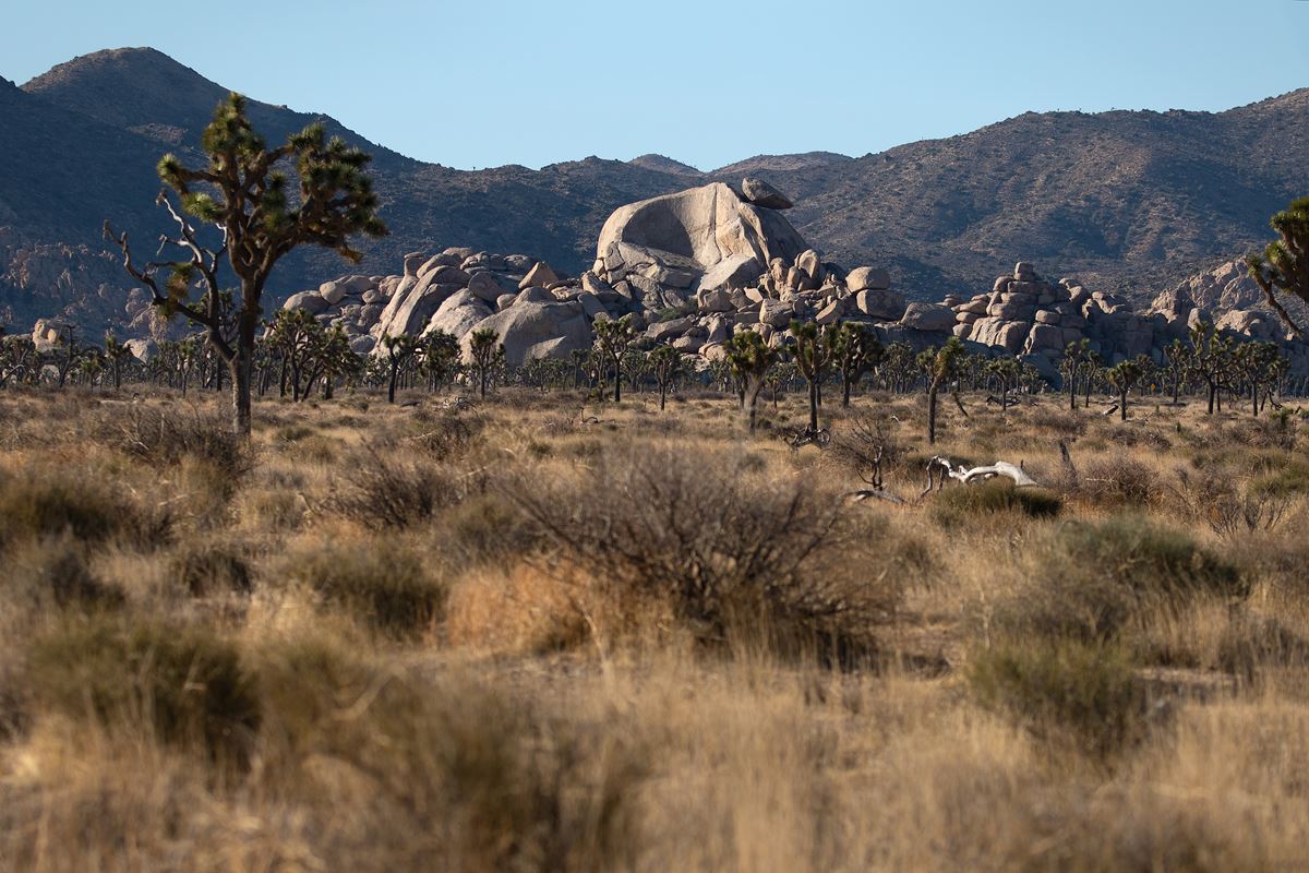
Cap Rock Nature Trail is a short, mostly flat circuit through Joshua trees, Mojave yuccas and sculpted monzogranite formations. Interpretive signs explain local plants and wildlife, while benches provide places to rest.
Cap Rock itself is a popular rock formation in the park’s central area. The trail’s easy access, minimal elevation change and nearby picnic facilities make it suitable for a brief stop.
Getting to the trailhead
The trail begins and ends near Cap Rock, close to the northern end of Keys View Road. From Park Boulevard, turn onto Keys View Road and continue .2 miles to the trailhead.
Parking accommodates cars, buses and RVs. The lot has 2 standard accessible spaces and 25 other spaces. The trailhead area also has picnic tables, grills, recycling, trash receptacles and a scenic photo spot.
Joshua Tree Visitor Center is about 13 miles away. The gateway communities are Twentynine Palms, about 12 miles away; Joshua Tree, about 13 miles away; and Yucca Valley, about 17 miles away. These are straight-line distances, not driving distances.
Palm Springs International Airport (PSP) and Ontario International Airport (ONT) are airports associated with access to the park.
On the trail
The loop starts at about 4,270 feet and returns at about 4,270 feet. Its estimated high point is about 4,310 feet. The route has about 30 feet of total climbing and about 30 feet of descent.
The NPS also describes the trail as having 20 feet of elevation gain. Both figures reflect a route with little elevation change. Most of the trail is flat, with occasional mild inclines.
The native surface consists of dirt and gravel, with hard-packed sand along the route. Weather can leave the sand loose and deeper in some sections. Large overhanging boulders create possible barriers in several places.
Cap Rock is at the beginning of the mapped route. From there, the loop winds among other rock formations before returning to its starting point. Benches and interpretive signs appear along the way.
What you will see
The central feature is Cap Rock, a distinctive and popular formation near Park Boulevard and Keys View Road. The walk continues through nearby granite and monzogranite formations.
Joshua trees and Mojave yuccas grow beside the route. Signs provide information about the area’s plants and wildlife. The trailhead and Cap Rock area also serve as a designated scenic viewpoint and photography spot.
Shade is minimal throughout the loop. There is no cell service at the trail.
History and nature
Cap Rock Nature Trail is designed as an interpretive walk through the surrounding desert landscape. Its signs describe plants and wildlife found in the area.
The route also highlights the relationship between local vegetation and sculpted monzogranite. Cap Rock and the surrounding formations are the trail’s defining geological features.
When to go
The trail is available in winter, spring, summer and fall. It can be visited at dawn, during the day or at dusk. Joshua Tree National Park remains open 24 hours daily throughout the year, though some areas permit day use only.
Spring and fall generally bring the most comfortable temperatures. Average spring highs are around 85°F, while average fall lows are around 50°F. Park visitation rises as fall temperatures moderate and reaches its peak during spring wildflower season.
Winter days are around 60°F, while nights can fall below freezing. Snow occasionally reaches higher elevations. Summer days exceed 100°F, and nighttime temperatures may remain above 75°F. Summer visitation decreases during the heat.
Summer hikers should begin before 10 am and carry water. Typical conditions are clear, with humidity below 25%. Check the forecast and reconsider plans when weather becomes extreme.
Accessibility
The trail is described as wheelchair accessible. It has mostly flat dirt, gravel and hard-packed sand surfaces, plus occasional gentle inclines. The path averages 36 inches wide.
Loose or deep sand can affect passage after certain weather conditions. Several overhanging boulders may also create barriers.
A vault toilet stands near the parking area. It has grab bars but no running water. A 2-inch level change separates the toilet’s concrete pad from the surrounding ground.
The parking lot provides 2 standard accessible spaces. Service animals are welcome and must remain on a 6-foot leash.
Permits, fees and rules
Park entrance fees are:
- Private vehicle: $30
- Motorcycle: $25
- Per person: $15
The facts do not list a separate trail permit. Cap Rock Nature Trail is open only to hiking.
Pets and emotional support animals are prohibited on trails. Service animals are allowed but must stay on a 6-foot leash at all times. Follow all posted park rules and leave no trace.
Nearby trails and places
Minerva Hoyt Trailhead is about 0.4 miles away. Ryan Ranch Trailhead is about 0.6 miles away, and Ryan Campground is about 0.7 miles away. Juniper Flats Backcountry Trailhead is about 0.9 miles away.
Old Lost Horse Road is about 0.5 miles away and measures about 4.9 miles. Ruins/Lost Horse Well Road is about 0.7 miles away and measures about 1.5 miles. All trail lengths are mapped lengths.
Before you go
Check current conditions, weather and alerts on the park’s NPS website. The trail has little shade and no cell service, so carry water and pack layers appropriate for the season.
Tell a safety contact where the hike is and when departure from the park is planned. Use the vault toilet near the parking lot before starting if needed, since it has no running water.
Visitor centers operate on separate schedules from the park. Confirm Joshua Tree Visitor Center hours before making the trip there.
Questions
How long is Cap Rock Nature Trail?
It is about 0.4 miles as mapped by the National Park Service.
How long does it take to hike Cap Rock Nature Trail?
The typical duration is 15–45 minutes, and the NPS activity estimate is 25 minutes.
Is Cap Rock Nature Trail difficult?
No. The NPS rates it easy, with mostly flat terrain, mild inclines and minimal elevation change.
Is Cap Rock Nature Trail wheelchair accessible?
It is described as wheelchair accessible, but loose sand and overhanging boulders can create barriers.
Are dogs allowed on Cap Rock Nature Trail?
Pets and emotional support animals are prohibited. Service animals are welcome and must remain on a 6-foot leash.
Does Cap Rock Nature Trail have restrooms and parking?
Yes. The trailhead has parking, including 2 accessible spaces, and a vault toilet without running water.
What can hikers see on Cap Rock Nature Trail?
The loop passes Cap Rock, monzogranite formations, Joshua trees and Mojave yuccas. Signs cover local plants and wildlife.
How do visitors reach Cap Rock Nature Trail?
Turn from Park Boulevard onto Keys View Road and travel .2 miles to the trailhead.
Nearby
On the map
6 trails3 places to see6 visitor services
Facts on this page draw on the National Park Service: Cap Rock (nps.gov)