Washington National Parks Road Trip: A 7-Day Itinerary
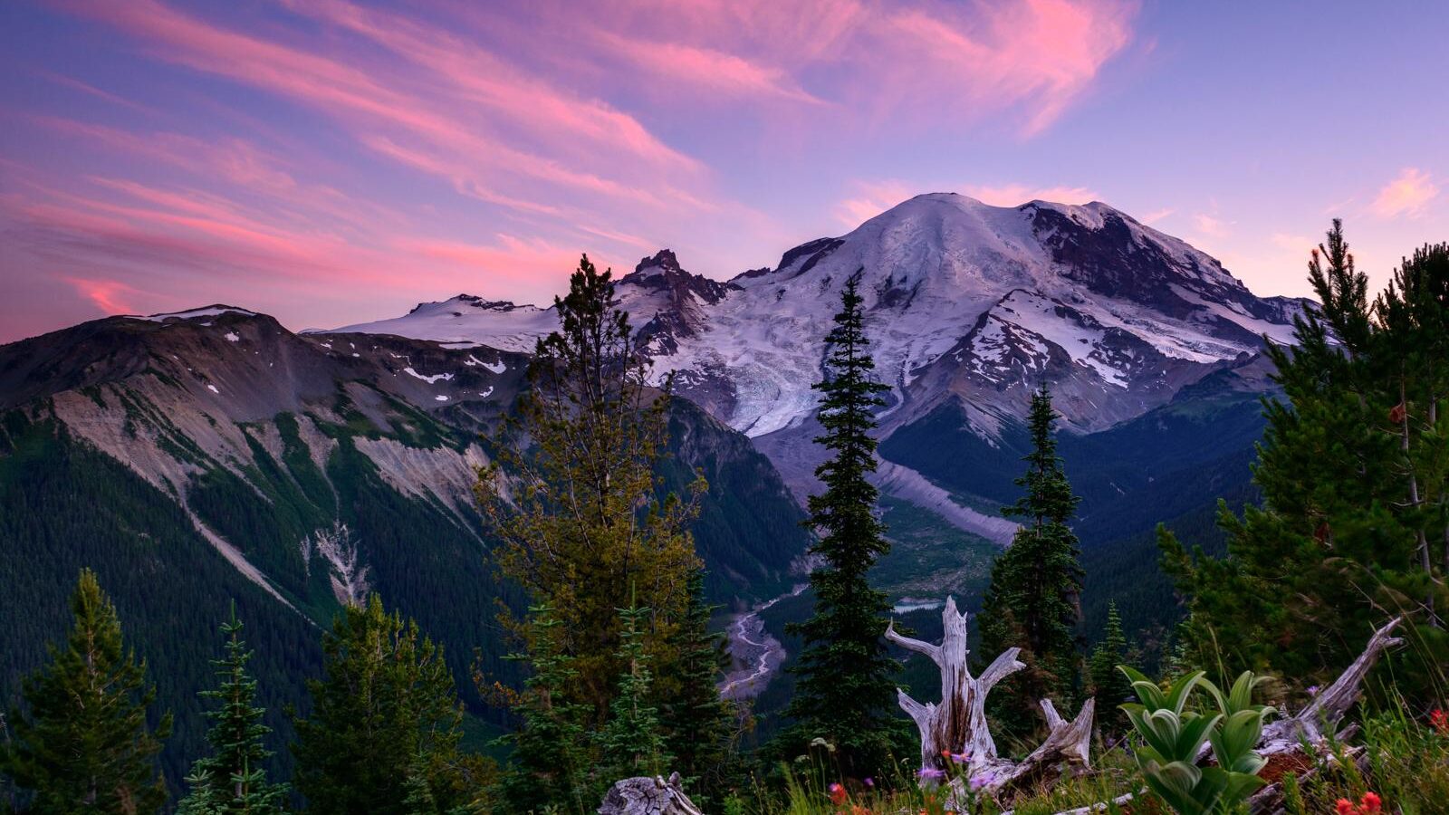
A Washington National Parks Road Trip connects glacier-covered Mount Rainier, the temperate rainforests and Pacific beaches of Olympic, and the serrated peaks of North Cascades in seven tightly planned days. The complete circuit covers roughly 850 miles from Seattle, with elevations ranging from sea level at Ruby Beach to 6,400 feet at Sunrise and more than 7,000 feet on accessible sections of the North Cascades Highway.
Our team recommends traveling clockwise through North Cascades, Olympic, and Mount Rainier. This order places the longest transfer early, uses the Coupeville to Port Townsend ferry to avoid backtracking through Seattle, and finishes beneath Washington’s 14,410-foot volcano. The itinerary below identifies the essential stops, realistic drive times, sensible overnight bases, and seasonal obstacles that can change the route.
How the Route Works
This seven-day circuit begins and ends in Seattle. It follows State Route 20 into North Cascades National Park, crosses Whidbey Island to the Olympic Peninsula, traces Olympic National Park from Hurricane Ridge to the Hoh Rain Forest, and continues around the southern peninsula to Mount Rainier National Park.
The route works best from July through September, when mountain roads and high trails are most likely to be open. North Cascades Highway usually closes across the mountains in winter, while snow can restrict access to Hurricane Ridge, Sunrise, Stevens Canyon Road, and many Rainier trails well into summer.
Why the Clockwise Order Saves Time
Visiting North Cascades first allows you to reach Diablo Lake and Washington Pass without repeating the Seattle corridor. After two nights near Marblemount, the route turns west through the Skagit Valley and across Whidbey Island. The ferry from Coupeville to Port Townsend provides direct access to the northeastern Olympic Peninsula, although its sailing time must be built into Day 3.
Olympic comes next because its major ecosystems form a natural east-to-west progression. Hurricane Ridge introduces the alpine interior, Lake Crescent provides low-elevation forest and water access, and the Hoh and Pacific coast occupy the wetter western side. Leaving through Lake Quinault positions you for the drive to Mount Rainier.
The 7 Days at a Glance
| Day | Primary stop | Main highlight | Approximate driving | Suggested overnight area |
|---|---|---|---|---|
| 1 | North Cascades Highway | Diablo Lake and Washington Pass | 4 to 5 hours | Marblemount or Newhalem |
| 2 | North Cascades National Park | Cascade Pass or Maple Pass | 1 to 2 hours | Marblemount or Newhalem |
| 3 | Whidbey Island and Port Angeles | Ferry crossing and Lake Crescent | 4.5 to 5.5 hours, including ferry time | Port Angeles |
| 4 | Northern Olympic Peninsula | Hurricane Ridge and Sol Duc | 2.5 to 3.5 hours | Forks |
| 5 | Western Olympic Peninsula | Hoh Rain Forest and Ruby Beach | 3 to 4 hours | Lake Quinault area |
| 6 | Mount Rainier | Longmire and Paradise | 4 to 5 hours | Ashford or inside the park |
| 7 | Mount Rainier and Seattle | Skyline Trail or Sunrise | 3 to 4.5 hours | Seattle |
Planning the Trip
Seven days leaves little room for missed ferry sailings, midday grocery stops, or searching for lodging after dark. Reserve accommodations before finalizing hikes, particularly around North Cascades and the Hoh Rain Forest, where practical bases are widely separated. Carry breakfast and trail food from Seattle so mornings can begin before parking areas fill.
Entrance procedures, timed-entry systems, ferry reservations, road access, and campground availability can change. Confirm current details on the official park and Washington State Ferries sites before departure. Pay particular attention to Mount Rainier entry procedures, Hurricane Ridge access, Cascade River Road conditions, and the operating status of State Route 20.
Fuel, Food, and Connectivity Gaps
Fill the tank in Sedro-Woolley before entering the North Cascades Highway corridor. Fuel options become sparse east of Marblemount and around Ross Lake. On Olympic, Port Angeles and Forks are the most useful resupply points. The stretch between the Hoh Rain Forest, Lake Quinault, and the southern peninsula has limited late-evening food choices.
- Download offline maps for State Route 20, Cascade River Road, western Olympic, and Mount Rainier.
- Carry at least two liters of water per person for exposed mountain hikes.
- Pack a cooler because dining hours near remote park entrances can be limited.
- Keep a paper map available for forest roads and areas without cellular service.
- Bring a tire inflator and check the spare before using rough trailhead roads.
Choosing the Right Travel Season
Late July and August provide the best odds of reaching every high-elevation stop, but they also bring crowded trailheads, wildfire smoke, and afternoon heat east of the Cascade crest. September usually offers cooler hiking conditions and fewer mosquitoes. Early snow can arrive in the mountains before conditions change at sea level.
Spring travelers should expect a modified itinerary. The North Cascades Highway may remain closed, Hurricane Ridge can retain deep snow, and Rainier’s Paradise trails may require traction or snowshoes. In autumn, shorter daylight makes the western Olympic drives more demanding because elk and deer frequently enter roads near dusk.
Days 1 and 2: North Cascades Highway and Alpine Trails
Leave Seattle early on Day 1 and follow Interstate 5 north before turning east toward Sedro-Woolley and State Route 20. The landscape changes quickly beyond Marblemount as the Skagit River passes through steep valleys carved by Pleistocene glaciers. Highway overlooks provide access to turquoise reservoirs surrounded by peaks built largely from metamorphic and igneous rock.
North Cascades National Park has relatively little road access, so the highway corridor serves as the practical introduction. Many famous summits, including Mount Shuksan and Mount Triumph, require backcountry travel. The first two days instead focus on viewpoints and maintained day hikes that fit a seven-day schedule.
Day 1: Diablo Lake and Washington Pass
Stop first at the North Cascades Visitor Center area near Newhalem, then continue to Diablo Lake Overlook. The lake’s blue-green color comes from fine glacial sediment called rock flour, which remains suspended in the water and scatters light. Continue east to Rainy Pass and Washington Pass if the highway is open.
Washington Pass Overlook
The short paved path overlooks the tight highway switchbacks beneath Liberty Bell Mountain, whose pale granite spires rise above the pass. Wind funnels through the notch, and temperatures can be substantially lower than in the Skagit Valley. From the railing, the road appears far below while talus slopes drop sharply beyond the pavement, giving an immediate sense of the range’s vertical scale.
Day 2: Select One Major Hike
Use Day 2 for a single substantial trail rather than combining distant trailheads. Cascade Pass is 7.4 miles round trip with roughly 1,800 feet of elevation gain, reached via Cascade River Road. The route climbs through forest and opens onto meadows facing Johannesburg Mountain, where waterfalls descend from hanging glaciers.
Maple Pass Loop is another strong choice when State Route 20 is fully open. The 7.2-mile circuit gains about 2,000 feet and overlooks Rainy Lake and surrounding peaks. For a shorter day, Thunder Knob covers approximately 3.6 miles round trip with around 425 feet of gain, ending above Diablo Lake.
Day 3: Crossing to the Olympic Peninsula
Day 3 is the itinerary’s most complicated transfer. Drive west through the Skagit Valley, cross onto Whidbey Island, and continue to the Coupeville ferry terminal. After landing in Port Townsend, follow the peninsula west toward Port Angeles. A missed sailing can consume enough time to eliminate the day’s final stop, so arrive well before your planned departure.
The journey crosses several distinct environments within a few hours. The glaciated North Cascades give way to agricultural lowlands, marine bluffs, and the rain-shadow forests of northeastern Olympic. Port Angeles makes the most efficient overnight base because it sits between the ferry route, Hurricane Ridge Road, and Lake Crescent.
Lake Crescent as the Essential Afternoon Stop
If the ferry connection runs smoothly, continue about 20 miles west of Port Angeles to Lake Crescent. This deep, clear lake occupies a glacially carved basin isolated from neighboring watersheds by an ancient landslide. The separation helped produce distinctive fish populations, including the Beardslee trout.
The 1.8-mile round-trip Marymere Falls Trail begins near the lake and passes through western hemlock, Douglas fir, and moss-covered bigleaf maple. The 90-foot waterfall drops through a narrow basalt gorge. Return to Port Angeles before dark rather than continuing toward Forks, because Day 4 begins with the climb to Hurricane Ridge.
Days 4 and 5: Olympic Mountains, Rainforest, and Coast
Day 4 links Olympic National Park’s dry northeastern mountains with the wetter Sol Duc Valley. Leave Port Angeles early for Hurricane Ridge, then descend to US 101 and continue west past Lake Crescent. Ending in Forks prevents unnecessary backtracking and places you within practical morning range of the Hoh Rain Forest.
Day 5 moves through the park’s wettest landscapes. The Hoh watershed receives roughly 140 inches of precipitation in a typical year, supporting Sitka spruce, western hemlock, nurse logs, and dense curtains of moss. After the rainforest, US 101 reaches the Pacific coast before turning south toward Lake Quinault.
Day 4: Hurricane Ridge and Sol Duc Falls
Hurricane Ridge Road climbs from near sea level to approximately 5,200 feet in about 17 miles. On a clear morning, the ridge reveals Mount Olympus and the Bailey Range across the Elwha Valley. Hurricane Hill is a 3.2 mile round trip hike with about 650 feet of gain, but the exposed route can be windy even when Port Angeles is calm.
Continue west to Sol Duc Falls, reached by a forest trail of approximately 1.6 miles round trip. The river divides into several channels before dropping into a narrow gorge, creating a different waterfall structure than Marymere Falls. Allow about two hours for the walk and forest stops before driving to Forks.
Day 5: Hoh Rain Forest Before Ruby Beach
Start with the 0.8 mile Hall of Mosses loop or combine it with the 1.2 mile Spruce Nature Trail. Roosevelt elk frequently use the valley, so keep substantial distance and never stand between a cow and calf. The longer Hoh River Trail continues toward Mount Olympus, but a short visit preserves enough daylight for the coast.
At Ruby Beach, consult the tide forecast before walking around headlands or approaching sea stacks. Wet driftwood rolls unpredictably in surf, and sneaker waves can reach well beyond the previous waterline. From the beach, continue south through Kalaloch to Lake Quinault for the night.
Days 6 and 7: Mount Rainier and the Return to Seattle
Day 6 begins with the long transfer from Lake Quinault to Mount Rainier’s Nisqually Entrance, generally using US 101, State Route 8, Interstate 5, and State Route 7. Aberdeen, Olympia, or the Interstate 5 corridor provide the most reliable fuel and grocery stops. Reach Longmire before climbing toward Paradise.
At 5,400 feet, Paradise sits beside subalpine meadows shaped by heavy winter snowfall and a compressed growing season. Early summer trails may remain snow covered while lower valleys are already warm. Spend the night near Ashford or inside the park so Day 7 can begin before parking pressure builds.
Day 6: Longmire and a Short Paradise Walk
Longmire’s Trail of the Shadows forms an easy 0.7 mile loop through forest, wetlands, and mineral spring sites associated with the area’s early resort history. At Paradise, the 1.2 mile Nisqually Vista Trail provides glacier views without the time commitment of Skyline. This pairing suits an afternoon arrival after several hours of driving.
Day 7: Choose the Hike That Fits the Weather
| Trail | Distance | Approximate gain | Best use |
|---|---|---|---|
| Skyline Trail | 5.5 miles | 1,700 feet | Clear weather and a full morning |
| Nisqually Vista | 1.2 miles | 200 feet | Clouds, limited time, or lingering snow |
| Grove of the Patriarchs area | Access dependent | Minimal | Use only when the route and trail are open |
The Skyline Trail climbs toward Panorama Point, where views can include the Nisqually Glacier, Mount Adams, and the Tatoosh Range. Turn around if visibility collapses or snow obscures the route. Sunrise is a worthwhile alternative only when its seasonal road is open and your overnight location makes the extra travel practical.
What to Keep and What to Cut
A successful Washington National Parks Road itinerary protects the defining experience in each region: a North Cascades alpine viewpoint, Olympic’s mountain to rainforest transition, a Pacific beach, and one substantial Mount Rainier walk. These stops reveal the geographic range of the circuit without requiring dawn to dark driving every day.
Essential Stops
- Diablo Lake Overlook and Washington Pass when State Route 20 is open
- One major North Cascades hike rather than several shortened attempts
- Hurricane Ridge, the Hoh Rain Forest, and Ruby Beach
- Paradise and either Skyline or Nisqually Vista
Optional Detours to Drop First
Skip Sunrise when clouds hide the mountain or when reaching it would delay the Seattle return. Remove Sol Duc if the ferry crossing runs late, and shorten the Hoh visit if coastal tides create a narrow safe window at Ruby Beach. Cape Flattery and Shi Shi Beach require substantial travel beyond this seven day circuit and fit better in a longer Olympic itinerary.
Gear & Essentials
Tell us about your trip and we will add what else you will want:
The basics
Worth having in the car whatever the park.
For this trip
As an Amazon Associate we earn from qualifying purchases, at no extra cost to you.
Completing the Loop
This route succeeds because each overnight location prepares for the following morning. Marblemount supports early North Cascades trail access, Port Angeles serves Hurricane Ridge, Forks positions you for the Hoh, Lake Quinault shortens the Rainier transfer, and Ashford keeps the final mountain day efficient.
Build flexibility around weather rather than forcing every viewpoint into the schedule. Mountain clouds, coastal tides, wildfire smoke, and lingering snow affect these parks differently on the same day. With food packed, offline maps downloaded, and one priority hike selected for each mountain park, the circuit delivers Washington’s three national parks in a demanding but workable week.