Canyonlands National Park: The Perfect One-Day Itinerary
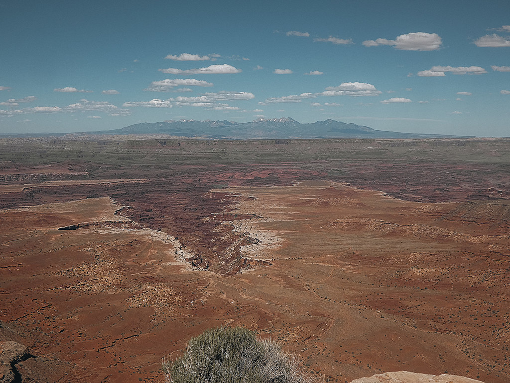
Photo: concrete&fells via Flickr (CC BY 2.0)
We call this our Canyonlands National Park Perfect day because it concentrates on one district rather than wasting hours driving between disconnected sections of the park. Island in the Sky, The Needles, The Maze, and the river corridors have separate access routes. Driving from Island in the Sky to The Needles takes roughly two hours, even though both districts appear close together on a map.
For a first visit, Island in the Sky provides the strongest one day route. Its paved scenic road reaches Mesa Arch, Grand View Point, Green River Overlook, Upheaval Dome, and viewpoints above the White Rim. The plateau stands around 6,000 feet above sea level, approximately 2,000 feet above the Colorado and Green rivers, so short walks reveal an unusually large amount of terrain.
Why the Perfect Canyonlands National Park Route Uses Island in the Sky
Island in the Sky occupies a broad sandstone mesa north of the rivers’ confluence. The Colorado River bounds its eastern side, while the Green River defines the western side. Layers of Wingate Sandstone, Kayenta Formation, and Navajo Sandstone form the cliffs, benches, and rounded domes visible from the overlooks. This geology creates long sightlines across the White Rim, a pale sandstone shelf winding below the mesa.
Four districts with no internal connecting road
Island in the Sky and The Needles each have paved entrances, but no park road joins them. The Maze requires remote, high clearance travel and considerably more time. The rivers form another district explored primarily by boat. A one day attempt to combine districts replaces hiking and overlooks with highway mileage, so our route stays entirely on the Island in the Sky mesa.
Why first time visitors gain more from this district
Most major Island in the Sky viewpoints sit within a short walk of pavement. That makes it possible to see sunrise light beneath Mesa Arch, walk the Grand View Point rim, study both river basins, and reach Upheaval Dome before evening. The Needles rewards longer hikes among Cedar Mesa Sandstone spires, especially Chesler Park and Druid Arch, but those routes need most or all of a day by themselves.
Canyonlands National Park: The Perfect One-Day Itinerary at a Glance
The route follows the main scenic road to its southern end first, then returns north and turns toward Upheaval Dome. This order places the most exposed rim walks in the cooler morning and saves shorter overlooks for later. It also limits repeated driving along the park’s dead end roads.
Canyonlands National Park: The Perfect Stop-by-Stop Schedule
Sunrise changes through the year, so treat the clock times below as a sequence rather than a rigid schedule. Begin at Mesa Arch around first light, reach Grand View Point before late morning, and reserve the afternoon for the western side of the mesa. Drive times exclude parking, photography, and walks.
| Time of day | Stop | Primary highlight | Approximate drive time |
|---|---|---|---|
| Dawn | Mesa Arch | 0.6 mile loop and sunrise over Buck Canyon | About 40 minutes from Moab |
| Early morning | Grand View Point | Rim walk above the White Rim and Monument Basin | About 20 minutes |
| Late morning | White Rim Overlook | Quiet peninsula above the Colorado River side | About 10 minutes |
| Early afternoon | Green River Overlook | Views across Soda Springs Basin toward the Maze | About 25 minutes |
| Mid afternoon | Upheaval Dome | Short, steep walk into an eroded impact structure | About 15 minutes |
| Late afternoon | Shafer Canyon viewpoints | Cliffs, switchbacks, and eastern light | About 20 minutes |
Essential stops and optional additions
Mesa Arch, Grand View Point, Green River Overlook, and the first Upheaval Dome overlook form the core itinerary. White Rim Overlook adds a 1.8 mile round trip walk and should be skipped during extreme heat or when the day starts late. Aztec Butte requires scrambling on exposed slickrock and fits only when everyone in the group moves confidently on steep sandstone.
- Keep: Mesa Arch, Grand View Point, Green River Overlook, and Upheaval Dome.
- Add with two extra hours: White Rim Overlook or the full Grand View Point Trail.
- Skip when time is tight: Aztec Butte and lengthy roadside photography stops.
- Avoid in a standard rental car: Unpaved four wheel drive routes such as the White Rim Road.
Logistics Before Entering the Park
Island in the Sky is reached from Moab via US 191 and Utah 313. The junction lies north of town, and the road climbs gradually through open desert before reaching the park entrance. Moab is the practical overnight base because it offers the region’s broadest selection of lodging, groceries, fuel, and prepared food. Staying there also supports a predawn departure without committing to remote backcountry camping.
Fuel, meals, water, and mobile service
Fill the fuel tank and buy breakfast and lunch before leaving Moab. Once on the mesa, food options are extremely limited, shade is scarce, and mobile service becomes unreliable. Carry at least three to four liters of water per person during warm weather, plus salty snacks and a lunch that tolerates heat. Pack out every scrap because ravens quickly learn to raid unattended bags.
Entrance timing and seasonal constraints
Arriving before sunrise avoids the slowest entrance traffic and improves the chance of finding a space near Mesa Arch. Winter ice can remain on shaded paths after exposed roads have dried, while summer temperatures regularly make unshaded afternoon walks strenuous. Spring winds can carry sand across overlooks. Entrance fees, road conditions, closures, and service availability can change, so confirm current details on the official park site.
The Perfect Canyonlands National Park Morning: Mesa Arch to Grand View
The morning sequence covers the park’s most recognizable arch and its broadest accessible rim. Carry a warm layer even in late spring because the exposed plateau can feel sharply colder than Moab before sunrise. After the sun clears the La Sal Mountains, temperatures rise quickly and shade nearly disappears.
Mesa Arch at first light
The Mesa Arch loop is approximately 0.6 mile and crosses uneven slickrock, stone steps, and sandy patches. From the parking area, follow the loop clockwise or counterclockwise to the arch, which sits directly on a cliff edge above Buck Canyon. Photographers cluster here at sunrise because reflected light illuminates the underside of the arch, but the trail remains worthwhile after the first crowd disperses.
Near the rim, sandstone feels cold and gritty under your palms, while wind moves upward from the canyon with little warning. The ground beyond the arch drops abruptly into Buck Canyon. Through the opening, Washer Woman Arch rises from a narrow fin, the La Sal Mountains hold the eastern skyline, and deeply cut drainages spread below at a scale the parking area never suggests.
How to handle the sunrise crowd
Stay behind the exposed rim and avoid stepping between tripods. After sunrise, walk a short distance along the loop before returning to the arch. The changing angle reveals more of the canyon walls, and many visitors leave within 20 minutes of the sun appearing. Allow 45 to 60 minutes for the complete stop.
Grand View Point and the southern rim
Continue south to Grand View Point, near the end of the paved scenic road. The overlook faces across Monument Basin toward distant spires and mesas, with the White Rim tracing a pale line below. The full Grand View Point Trail follows the cliff edge for about 1.8 miles round trip. Its modest elevation change disguises persistent sun exposure, uneven rock, and several places where the route approaches substantial drop offs.
Short visit or full rim walk
Travelers keeping a tight schedule can use the paved overlook and walk only the opening section of the rim trail. Allow roughly 30 minutes for that version. The complete trail generally needs 60 to 90 minutes and ends at a natural viewpoint above the confluence region, although the actual meeting of the Green and Colorado rivers remains hidden by intervening canyon walls.
White Rim Overlook as the morning detour
Backtrack from Grand View Point to the White Rim Overlook trailhead. The 1.8 mile round trip route crosses open slickrock and low desert vegetation to a peninsula overlooking Gooseberry Canyon and the Colorado River side of the park. Pinyon pine, Utah juniper, blackbrush, and biological soil crust occupy the shallow soils, so remain on rock or the established path to avoid damaging the living crust.
Finishing the Afternoon on the Western Mesa
After White Rim Overlook, return north along Grand View Point Road and stop at Buck Canyon Overlook if visibility is clear. This roadside viewpoint looks east across a broad drainage toward the La Sal Mountains, whose highest summit, Mount Peale, reaches 12,721 feet. Haze often increases during the afternoon, so spend only a few minutes here when distant features have disappeared.
Green River Overlook
Turn onto Upheaval Dome Road and follow the spur to Green River Overlook. From the rim, the Green River curves through Stillwater Canyon below Ekker Butte and the Orange Cliffs. The river may appear surprisingly small because the overlook stands roughly 1,300 feet above it. Late afternoon light defines the terraces and side canyons better than the flatter illumination around midday.
Upheaval Dome and its two overlooks
Upheaval Dome is an eroded impact structure approximately three miles across. Rock layers tilt sharply around a central basin containing pale, disrupted material. The first overlook requires a steep round trip of roughly 0.8 mile, including rock steps and slickrock. Continuing to the second overlook increases the outing to approximately 1.8 miles and provides a broader view into the structure.
When to turn around
Choose the first overlook when daylight is limited, temperatures remain high, or anyone in the group is uncomfortable on uneven rock. The second viewpoint adds useful geological perspective but involves additional climbing without shade. Avoid exposed slickrock when thunderstorms are nearby because lightning, runoff, and rapidly wet sandstone can make the route hazardous.
Optional Detours Without Derailing the Route
The Canyonlands National Park Perfect schedule leaves little room for long hikes, but several short additions fit when the group finishes Grand View Point early. Select one detour rather than collecting every roadside stop. This preserves enough daylight for Upheaval Dome and prevents the final hour from becoming a rushed drive back toward the entrance.
Aztec Butte for experienced scramblers
Aztec Butte is a roughly two mile round trip hike to ancestral Puebloan granaries and a high slickrock summit. The route climbs steep sandstone where cairns can be difficult to follow. Granaries are protected archaeological resources, so view them without entering, touching masonry, or removing pottery fragments. Skip this trail during rain, strong wind, or icy conditions.
Shafer Canyon at the end of the day
Near the visitor center, Shafer Canyon Overlook reveals the switchbacks of Shafer Trail descending through the Wingate Sandstone cliffs. Passenger vehicles should remain on pavement unless the driver has appropriate clearance, backcountry preparation, and experience on narrow shelf roads. The overlook itself provides the essential view and adds little walking to the itinerary.
- Extra 20 minutes: Stop at Buck Canyon Overlook.
- Extra 45 minutes: Walk to the first Upheaval Dome overlook and return.
- Extra two hours: Choose Aztec Butte only if conditions are dry and the group handles scrambling confidently.
- Running late: Use Shafer Canyon Overlook, then begin the drive toward Moab before darkness.
Seasonal Adjustments and the Overnight Plan
Elevation makes Island in the Sky cooler than Moab, but most trails remain fully exposed. March through May and September through October usually provide the most comfortable hiking windows. Summer requires a shorter afternoon program, while winter can deliver quiet overlooks alongside snow, black ice, and concealed trail edges.
How the schedule changes through the year
| Season | Likely conditions | Best adjustment |
|---|---|---|
| Spring | Cool mornings, strong wind, occasional storms | Secure hats and avoid rim walks when thunder develops |
| Summer | Intense sun, heat, monsoon storms | Complete longer walks before noon and shorten the afternoon |
| Autumn | Cooler hiking weather and shorter daylight | Start early and set a firm turnaround at Upheaval Dome |
| Winter | Cold wind, snow, and shaded ice | Carry traction and favor paved overlooks after storms |
Where to sleep after the drive
Moab remains the simplest overnight choice, especially for travelers continuing to Arches National Park or south on US 191. Lodging ranges from motels and vacation rentals to developed campgrounds. Camping closer to Utah 313 reduces the return drive, but food and fuel are farther away. Arrive with dinner already purchased if using a remote campsite.
Completing Your Perfect One-Day Canyonlands National Park Itinerary
A successful one day visit depends on disciplined geography. Stay in Island in the Sky, place the longer rim walks in the morning, and use Green River Overlook and Upheaval Dome to organize the afternoon. Mesa Arch, Grand View Point, and the western mesa then reveal both major river basins without requiring backcountry driving.
Build flexibility around daylight, heat, and walking speed. White Rim Overlook, Aztec Butte, and the second Upheaval Dome viewpoint are optional, while water, fuel, sun protection, and an early departure are essential. With those priorities settled before leaving Moab, the route delivers a complete and manageable Canyonlands day rather than an exhausting race between districts.
Want to keep exploring? Browse all our Canyonlands guides and articles for more trip-planning tips and ideas.
Gear & Essentials
Tell us about your trip and we will add what else you will want:
The basics
Worth having in the car whatever the park.
For this trip
Traveling with kids
Bringing a pet
RVing
Backcountry
Winter conditions
On the water
Photography
Accessibility
As an Amazon Associate we earn from qualifying purchases, at no extra cost to you.