Shenandoah National Park in Fall: What to Expect and What to Do
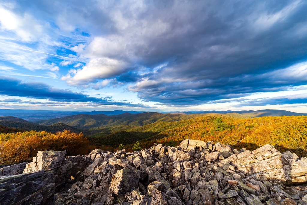
Photo: aparlette via Flickr (CC BY 2.0)
Our Shenandoah National Park Fall advice is straightforward: visit on weekdays, enter before midmorning, and match your route to the elevation where color is strongest. Autumn foliage generally develops first around Hawksbill Mountain and the park’s other high ridges, then progresses toward lower slopes and valleys. Peak color cannot be predicted to an exact weekend because temperature, rainfall, wind, and elevation all affect timing.
Shenandoah extends for roughly 75 miles along Virginia’s Blue Ridge, with 105-mile Skyline Drive connecting four entrance stations. Elevation ranges from about 560 feet near the park boundary to 4,050 feet on Hawksbill, creating several overlapping autumn seasons. A single October drive can pass from bare upper branches through peak color and into green forest.
Planning Your Fall Visit
For the broadest mix of color, comfortable hiking, and operating visitor services, target the middle three weeks of October. Early October often suits hikers seeking warmer afternoons and lighter weekday traffic. Late October and early November bring color to lower elevations, clearer long-distance views, colder nights, and fewer open seasonal facilities.
How Fall Color Moves Through Shenandoah National Park
The highest ridges usually change first. Northern red oak, chestnut oak, red maple, black gum, hickory, and tulip poplar contribute different colors on different schedules. Black gum can turn scarlet while much of the surrounding canopy remains green. Oaks frequently hold copper, russet, and deep red leaves after maples and tulip poplars have dropped theirs.
Elevation matters, but slope direction and moisture matter too. Cooler north-facing hollows may change differently from exposed west-facing ridges. A hard frost can accelerate color, while strong wind and heavy rain can strip high ridges overnight. Instead of treating one forecasted date as definitive, our team recommends identifying hikes at several elevations.
Comparing Early, Mid-, and Late Fall in Shenandoah National Park
| Period | Typical conditions | Crowds | Access | Best uses |
|---|---|---|---|---|
| September to early October | Warm afternoons, cooler ridge mornings, scattered color at high elevations | Moderate, with busier weekends | Skyline Drive and most trails generally accessible | Long hikes, waterfalls after rain, wildlife watching |
| Mid to late October | Cooler days, cold nights, strongest color across many elevations | Highest of the season, especially on weekends | Road and trail access usually broad unless storms intervene | Scenic driving, overlooks, ridge hikes, photography |
| Late October to mid November | Color shifts downslope, exposed summits become colder and windier | Moderate on weekends, lighter on weekdays | Some seasonal services begin scaling back | Lower-elevation hikes, open views, quieter overlooks |
| Late November onward | Mostly bare canopy, freezing nights, possible ice or snow | Low outside holiday periods | Weather can temporarily close sections of Skyline Drive | Long-range views, solitude, winter-style hiking |
Understanding Skyline Drive and the park’s elevations
Skyline Drive follows the crest of the Blue Ridge from Front Royal to Rockfish Gap. The posted speed limit is 35 mph, and driving the full road takes about three hours without meaningful stops. In fall, overlook traffic, wildlife, fog, and slow vehicles can add considerably more time. A successful day usually focuses on one district rather than the entire road.
Choose the right entrance for your itinerary
Four entrances divide the park into practical touring zones. Front Royal serves the northern end. Thornton Gap, reached from U.S. Route 211, provides direct access to the central section near Marys Rock. Swift Run Gap on U.S. Route 33 reaches the central and southern districts, while Rockfish Gap on Interstate 64 connects with the southern terminus and Blue Ridge Parkway.
- North District: Choose Front Royal for overlooks, the Dickey Ridge area, and quieter alternatives to the central district.
- Central District: Use Thornton Gap for Stony Man, Hawksbill, Big Meadows, and Dark Hollow Falls. This is usually the busiest fall section.
- South District: Enter at Swift Run Gap or Rockfish Gap for longer ridge drives, fewer concentrated attractions, and generally lighter traffic.
Why weather changes so quickly on the ridge
Skyline Drive repeatedly climbs above 3,000 feet, where temperatures can be markedly lower than in Charlottesville, Luray, or Washington’s Virginia suburbs. Wind also increases heat loss at exposed overlooks. Fog can reduce visibility to a few car lengths, particularly when moist air rises against the Blue Ridge. Pack for the mountaintop rather than the entrance station.
The ridge’s bedrock helps explain its form. Ancient granitic rocks occur alongside Catoctin greenstone, which began as basaltic lava roughly 570 million years ago. Erosion later carved hollows and left resistant ridges. Rocky talus, thin summit soils, and sheltered stream valleys now support plant communities that respond differently to drought and frost.
What to Expect from Fall Crowds in Shenandoah National Park
October weekends produce the park’s heaviest traffic because foliage viewers, hikers, campers, and through-drivers converge on the same narrow road. The effects extend beyond entrance lines. Popular trailheads fill early, vehicles circulate through small parking areas, and cars may line designated roadside spaces near Stony Man, Dark Hollow Falls, and Hawksbill.
Where congestion is most noticeable
Big Meadows and the central district absorb much of the demand. This area combines lodging, camping, meadow wildlife, waterfalls, and access to the park’s highest summit. Dark Hollow Falls is especially busy because the waterfall lies only about 0.7 mile from the trailhead, though the return climb is steep. Hawksbill also draws visitors using several routes to reach the 4,050-foot summit.
The experience at Stony Man
Near the Stony Man viewpoint, packed earth gives way to angular greenstone beneath your boots. The forest thins, the wind becomes more apparent, and the Shenandoah Valley opens abruptly beyond the ledge. Massanutten Mountain stretches across the middle distance while farms sit far below. The exposed rock feels several degrees colder than the sheltered trail, especially late in the afternoon.
How to reduce waiting and parking problems
- Enter early enough to reach your first trailhead before the main sightseeing traffic arrives.
- Use a weekday for Stony Man, Hawksbill, Dark Hollow Falls, or Big Meadows.
- Keep a second trail at a different milepost ready in case the first parking area is full.
- Avoid stopping in travel lanes or on soft shoulders where parking is prohibited.
- Plan food and fuel before entering so one crowded service area does not control the day.
Sunset creates another concentrated rush at west-facing overlooks, followed by heavy traffic leaving the ridge in darkness. Deer are active near road edges, and black bears occasionally cross Skyline Drive. Allow extra braking distance, use overlooks only where the vehicle fits completely outside the travel lane, and expect temperatures to drop quickly after sunset.
Road access, reservations, and fall permits
Skyline Drive generally remains open throughout fall, but ice, snow, downed trees, wildfire activity, or emergency work can close individual sections. Because entrances are widely separated, a closure may require a lengthy route around the mountains. Seasonal lodging, food service, campgrounds, and visitor facilities also reduce operations as autumn advances.
What needs advance planning
Fall weekends are the hardest time to secure developed campsites and rooms inside the park. Book reservable accommodation as soon as your dates are firm, then build a backup plan in gateway communities near Front Royal, Luray, Elkton, or Waynesboro. Current entrance fees, campground availability, facility schedules, road status, and reservation rules should be confirmed on the official park site.
Old Rag and backcountry trips
Old Rag’s exposed granite scramble makes it one of the park’s most requested fall hikes. The standard circuit covers roughly 9 miles and includes tight passages, boulder moves, and about 2,400 feet of climbing. A seasonal day-use ticket system has applied during the busiest part of the year, separate from park admission. Backpackers should also review current backcountry permit and camping regulations before setting out.
When weather limits access
Rain leaves roots, fallen leaves, and Old Rag’s granite slabs slippery. Freezing conditions can create shaded ice even when valley roads are dry. If Skyline Drive closes, boundary trailheads may still provide access to lower-elevation routes, but parking and local road conditions vary. Carry a paper map because mobile coverage is unreliable in hollows and along much of the ridge.
What to Do in Shenandoah National Park in Fall by Elevation and Conditions
Choose trails by recent weather as well as foliage reports. Ridge walks provide broad color views after several dry days, while waterfalls respond best to recent rain. Wet leaves conceal roots and loose stones, so a moderate trail can demand more time than its mileage suggests. Short daylight also matters by November. Start longer circuits early enough to finish before dusk, particularly in deep hollows where sunset disappears behind the ridge well before the published time.
For waterfalls and sheltered forest
Rose River Loop covers about 4 miles and descends through a stream valley to the 67-foot Rose River Falls. The return involves roughly 900 feet of climbing. South River Falls is another useful lower-elevation choice, with a 2.6-mile round trip to the viewpoint or approximately 4.4 miles if you continue to the base. After dry spells, reduced flow makes these walks better for forest color than waterfall photography.
For exposed views and rock scrambling
Bearfence Mountain delivers a 360-degree panorama from a compact route of roughly 1.4 miles, but the main circuit requires hands-on scrambling across exposed greenstone. Skip the scramble when rock is wet or icy and use the viewpoint route instead. Farther south, the 3.4-mile Turk Mountain out-and-back climbs through oak forest to westward views across the Shenandoah Valley, often with less congestion than central district summits.
How autumn compares with the rest of the year
A Shenandoah National Park Fall trip combines broad trail access with cool hiking temperatures, but it also brings the year’s greatest concentration of weekend visitors. Spring favors waterfalls and wildflowers, summer provides the longest days, and winter exposes distant ridges through leafless forest. The comparison below helps place October conditions in context rather than treating foliage as the only factor.
| Season | Weather pattern | Crowd level | Road and trail access | Best activities |
|---|---|---|---|---|
| Spring | Cool and wet, with rapid temperature changes | Light to moderate | Muddy trails and occasional late ice at elevation | Waterfalls, wildflowers, bird migration |
| Summer | Warm, humid, and prone to afternoon thunderstorms | Moderate, especially on weekends | Broad access, with dense vegetation along trails | Long hikes, camping, meadow walks |
| Fall | Cooler days, cold ridge nights, variable wind and fog | Heavy on October weekends | Generally broad access until wintry weather arrives | Foliage drives, summit hikes, wildlife watching |
| Winter | Cold, windy, with possible snow and ice | Low | Skyline Drive sections may close temporarily | Open views, solitude, winter hiking |
Choose spring or summer for water and daylight
April and May usually produce stronger waterfall flow than autumn because rainfall combines with limited leaf cover and lower evaporation. Wildflowers progress upward with elevation, from trilliums in sheltered hollows to later blooms along the ridge. Summer provides nearly five additional hours of daylight compared with late November, making it better for lengthy routes such as the 7.8-mile Doyles River and Jones Run circuit. Humidity, thunderstorms, and limited long-range visibility are the tradeoffs.
Choose winter for visibility and solitude
From December through March, bare hardwoods reveal slopes, rock formations, and valley views hidden during the growing season. Parking pressure drops substantially, although ice can make steep trails technically harder. Winter visitors need traction devices, insulating layers, and enough food and water to remain self-sufficient when seasonal services are unavailable. Road closures can divide Skyline Drive into inaccessible segments, so winter itineraries require flexible trail choices near more than one entrance.
Use your priorities to choose the right dates
Begin with the experience that matters most, then accept the corresponding tradeoff. Visitors seeking maximum foliage variety should favor mid October and split time between high ridges and lower valleys. Photographers who value quiet overlooks gain more from late October weekdays, when sunrise comes later and leaf loss reveals mountain contours. Distance hikers often prefer early October because daylight lasts longer and freezing conditions are less common.
Plan around one primary goal
- Peak color: Reserve flexible dates in October and select final trails by elevation.
- Lower crowds: Visit Tuesday through Thursday, or choose the South District during a busy weekend.
- Waterfalls: Favor the days following steady rain, while avoiding stream crossings during high water.
- Wildlife: Walk Big Meadows near dawn or late afternoon and keep legal viewing distances.
- Rock scrambling: Select a dry day for Bearfence or Old Rag and carry gloves with reliable grip.
Black bears feed heavily during autumn as they prepare for winter, using oak forests where acorns provide concentrated calories. Never leave food, scented items, or coolers unattended, and use designated storage systems at campsites. White-tailed deer are especially active around Big Meadows and along road margins near dusk. Wildlife activity makes slow, attentive driving essential even after the foliage traffic has thinned.
Build a weatherproof backup plan
Pair every exposed hike with a sheltered alternative. A windy Hawksbill morning can become a Rose River afternoon, while dense fog on Skyline Drive may justify dropping to a boundary trailhead below the cloud layer. Carry a waterproof shell, warm hat, gloves, headlamp, paper map, food, and more water than cool temperatures seem to require. Cotton clothing becomes uncomfortable quickly after rain or perspiration, so choose wool or synthetic layers that retain insulation when damp.
When to Go for the Best Fall Color
Shenandoah’s elevation range allows visitors to find autumn color over several weeks, provided they remain flexible about district and trail choice. Use high summits earlier in the season, lower valleys later, and weekdays whenever possible. Concentrating on one section of Skyline Drive leaves more time for walking, overlooks, and wildlife while reducing the hours lost to slow traffic.
The strongest plan combines one priority, one primary hike, and one backup suited to different weather. Check road status before departure, arrive with cold-weather layers, and allow extra time for wet leaves, fog, and early darkness. With those decisions made in advance, fall becomes easier to navigate even when color, crowds, and mountain weather refuse to follow a precise calendar.
Want to keep exploring? Browse all our Shenandoah guides and articles for more trip-planning tips and ideas.
Gear & Essentials
Tell us about your trip and we will add what else you will want:
The basics
Worth having in the car whatever the park.
For this trip
Traveling with kids
Bringing a pet
RVing
Backcountry
Winter conditions
On the water
Photography
Accessibility
As an Amazon Associate we earn from qualifying purchases, at no extra cost to you.