5 Best Easy Hikes in Bryce Canyon National Park
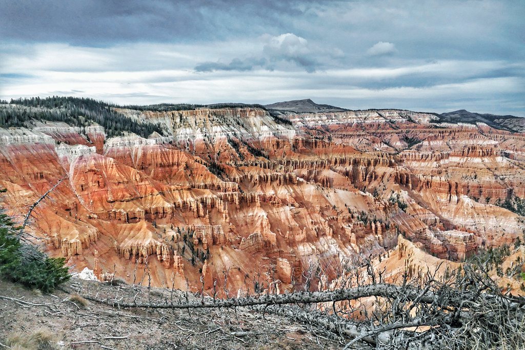
Photo: Bernard Spragg via Flickr (Public Domain Mark)
The best easy hikes Bryce Canyon offers are deceptively rewarding: despite the park’s reputation for demanding rim-to-canyon descents, roughly half of its maintained trails stay at or above the 8,000-foot rim elevation, cover flat ground through ponderosa pine forest, and still deliver views of hoodoos that most national parks could only dream of framing. The counterintuitive reality is that Bryce Canyon rewards visitors who move slowly and look closely far more than those who push miles. A short, well-chosen trail here packs in more concentrated geological drama per step than a full day’s hike in most other parks.
Bryce Canyon sits on the Paunsaugunt Plateau in southwestern Utah, about 50 miles east of Zion National Park and 75 miles south of Capitol Reef. The park’s main corridor runs roughly 18 miles from the entrance station near Bryce Canyon City south to Rainbow Point at 9,115 feet. Elevations across the park range from about 8,000 feet at the northern end near Bryce Amphitheater to that southern high point, which means even “flat” walks demand more from your lungs than the mileage suggests. Understanding that elevation difference before choosing a trail is the single most useful thing a first-time visitor can do. Confirm current entrance fees, shuttle schedules, and any permit requirements on the official park site before your visit, as operational details change seasonally.
What Makes Bryce Canyon’s Terrain Unlike Any Other Park
Hoodoos: The Science Behind the Spires
The orange, pink, and cream-colored columns that define Bryce Canyon are called hoodoos, and they form through a specific combination of frost-wedging and erosion that occurs here more aggressively than almost anywhere else on Earth. The Claron Formation limestone that makes up the canyon walls alternates between hard dolomitic caps and softer siltstone beneath them. Water seeps into cracks, freezes and expands (Bryce Canyon experiences more than 200 freeze-thaw cycles per year on average), and gradually pries the rock apart. The harder capstones resist erosion and protect pillars of the softer material below, creating the sentinel-like spires that can stand 200 feet tall.
The color banding visible in nearly every hoodoo tells a mineralogical story. Iron oxide creates the deep reds and oranges, manganese produces lavender and purple tones in some formations, and calcium carbonate produces the creamy white sections near the base. Easy hikes positioned at rim level or just below it put you eye-level with mid-column banding that photographs taken from overlooks above simply cannot capture. That intimate, close-range perspective is one of the clearest reasons to choose a walking trail over a parking-lot overlook.
Elevation, Light, and the Best Times of Day
The plateau’s elevation means Bryce Canyon receives significant snowfall from November through April, and afternoon thunderstorms are common from July through September. Morning light from the east strikes the east-facing amphitheater walls with particular intensity from roughly 7 a.m. to 10 a.m., turning hoodoos a saturated copper-orange that midday light flattens entirely. Photographers and hikers alike find that the first two hours after sunrise deliver colors and contrast unavailable at any other time. If you are planning an easy rim-level walk, starting at dawn also means cooler temperatures and dramatically thinner crowds, particularly during the peak summer months of June through August.
Orientation: Bryce Amphitheater and the Northern Trails Cluster
The Hub of Easy Hiking
Nearly all of the park’s easiest hiking is concentrated in and around Bryce Amphitheater, the large bowl-shaped depression that begins about a mile south of the main visitor center. This northern section of the park contains the famous overlooks: Sunrise Point, Sunset Point, Inspiration Point, and Bryce Point. These four viewpoints are connected by the Rim Trail, the longest and most accessible path in the park, and they also serve as trailheads for most of the easy-to-moderate routes that dip just below the canyon rim. Visitor facilities, the shuttle bus system, and the lodge are all clustered here, making logistics straightforward even for visitors with limited mobility or time.
The amphitheater sits at roughly 8,000 to 8,300 feet elevation, and its inner basin holds formations like Thor’s Hammer, a top-heavy hoodoo with a distinctive mushroom silhouette that has become one of the most photographed geological features in the American Southwest. You can see Thor’s Hammer from multiple points on the Navajo Loop Trail, one of the five hikes detailed below. The basin was carved primarily by the East Fork of the Sevier River system over millions of years, though today it drains into a network of seasonal streams that rarely run above a trickle.
Getting to the Trailheads
The park road between the visitor center and Bryce Point is about 3 miles one-way and can be driven year-round (check road conditions in winter). During peak season, the park operates a free shuttle system that stops at all major trailheads and overlooks within the amphitheater section, which reduces parking congestion considerably. Arriving before 9 a.m. or after 4 p.m. in summer dramatically improves your chances of finding a parking spot if you choose to drive. Rainbow Point and Yovimpa Point, the park’s southernmost destinations at 9,115 feet, require driving the full 18-mile main road and are not served by the shuttle; confirm current shuttle routes and operating windows on the official park site.
5 Best Easy Hikes in Bryce Canyon National Park: Complete Trail Overview
Comparing the Trails at a Glance
| Trail Name | Distance (round trip) | Elevation Change | Trailhead | Difficulty |
|---|---|---|---|---|
| Rim Trail (Sunrise to Sunset) | 1.0 mile one-way | Minimal (under 50 ft) | Sunrise Point | Easy |
| Bristlecone Loop | 1.0 mile loop | Approximately 100 ft | Rainbow Point | Easy |
| Mossy Cave Trail | 0.8 mile round trip | Approximately 150 ft | Highway 12 (outside main park) | Easy |
| Navajo Loop Trail | 1.3 mile loop | 550 ft descent and return | Sunset Point | Easy/Moderate |
| Queens Garden Trail | 1.8 mile round trip | 320 ft descent and return | Sunrise Point | Easy/Moderate |
How We Ranked the Best Easy Hikes in Bryce Canyon by Difficulty
At Bryce Canyon, “easy” requires a slightly adjusted definition compared to sea-level parks. We classified a trail as easy if it covers less than 2 miles round trip, involves no sustained scrambling or exposure, and keeps elevation change under roughly 350 feet for most of its length. The Navajo Loop and Queens Garden trails technically exceed that threshold slightly on the return climb, but their grades are manageable, well-graded switchbacks rather than steep pitches, and they remain among the most accessible below-rim experiences in the park. Visitors who are not acclimatized to altitudes above 8,000 feet should plan for shorter distances, carry extra water, and allow more time than the mileage alone suggests.
- Drink at least half a liter of water per mile, more in summer sun
- Allow 30 to 40 percent more time than you would for the same trail at lower elevation
- Wear sunscreen rated SPF 30 or higher; UV intensity increases roughly 4 percent per 1,000 feet of altitude
- Pack microspikes or traction devices if visiting between November and April, when trail surfaces can ice over
- Stay on designated trails to protect fragile cryptobiotic soil crusts that take decades to recover from a single footprint
Want to keep exploring? Browse all our Bryce Canyon guides and articles for more trip-planning tips and ideas.
Gear & Essentials
Before you head out, make sure you have the right gear for 5 Best Easy Hikes in Bryce Canyon National Park. These are our picks:
- TrailBuddy Aluminum Trekking Poles
- IRON FLASK Insulated Hiking Flask 32oz
- MAXTOP Crossbody Fanny Pack
- Merrell Men's Moab 3 Hiking Shoe
- Merrell Women's Moab 3 Mid Waterproof Boot
- Columbia Men's Watertight II Rain Jacket
As an Amazon Associate, we earn from qualifying purchases at no extra cost to you.