The Best Scenic Drives in and Around Black Canyon of the Gunnison National Park
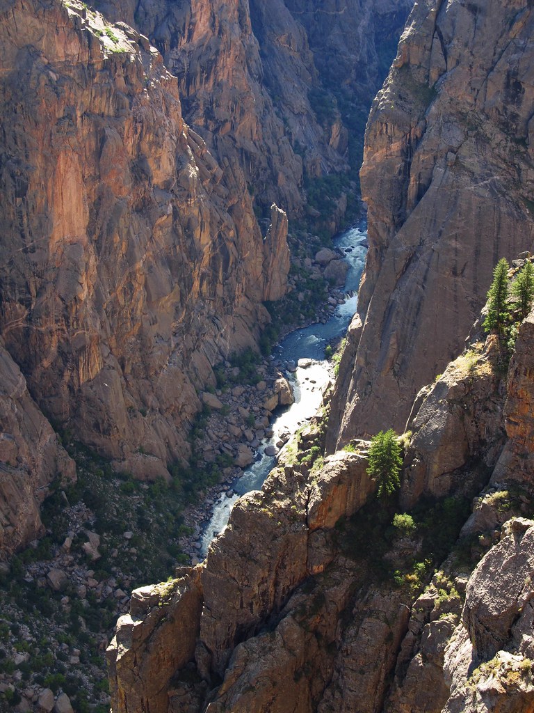
Photo: Jasperdo via Flickr (CC BY-NC-ND 2.0)
The best scenic drives around Black Canyon of the Gunnison National Park rank among the most visually arresting road experiences in the entire American West, and the canyon itself explains why the moment you step out of your car at Gunnison Point. Look down and the Inner Gorge drops more than 2,700 feet almost straight below your feet, its dark Precambrian walls of schist and gneiss streaked with white pegmatite like paint dragged across charcoal. The Gunnison River at the bottom, 53 miles long within the monument and national park boundaries, appears no wider than a silver thread from the rim, yet it carved this slot over two million years by cutting faster than the surrounding plateau could erode around it.
This guide covers the full suite of driving options centered on the park: the South Rim Drive and its overlooks, the shorter but equally dramatic North Rim Road, the wide-open Curecanti National Recreation Area corridor to the east along U.S. 50, and the scenic highway loops that connect Montrose and Gunnison through ranchland, reservoir country, and high mesa terrain. Whether you have a single afternoon or three full days, the drives in this region reward careful planning, and the details below give you the specifics to build a route that actually matches your schedule and vehicle.
Understanding the Landscape Before You Drive
Geology That Shapes Every Overlook
The walls of Black Canyon are composed primarily of 1.7-billion-year-old Precambrian rock, some of the oldest exposed geology in North America. The black color comes from the dominance of dark biotite schist and gneiss, which absorbs rather than reflects light, especially in the deep shadows the narrow canyon creates for most of the day. The bright white and pink veins slashing across the walls are pegmatite intrusions, crystallized magma that forced its way into fractures roughly 1.4 billion years ago. The most photographed of these formations, Painted Wall, rises 2,250 feet from river to rim, making it the tallest cliff face in Colorado.
The canyon’s extreme narrowness is the key detail to hold onto as you drive from overlook to overlook. At its narrowest point, the Narrows, the canyon is only 40 feet wide at the river level. This geometry means the canyon floor receives direct sunlight for only a short window each day, and the drives along both rims give you a fundamentally different perspective depending on the time of day you arrive. Morning light hits the South Rim walls first; late afternoon transforms the North Rim in ways the South Rim simply cannot replicate.
Orientation: Two Rims, One Canyon, Different Roads
The national park has two paved rim roads that dead-end rather than connect to each other by car. The South Rim Drive begins at the park’s main entrance off Colorado Highway 347, approximately 15 miles east of Montrose, and runs 6 miles east to High Point, reaching an elevation of 8,289 feet. The North Rim Road enters from Crawford via a county road and covers roughly 11 miles from the junction to the North Rim Campground, topping out near 8,600 feet. Driving between the two rims requires backtracking and taking a roughly 80-mile route through Montrose, Delta, and Crawford, a commitment of about two hours each way.
East of the park, U.S. Route 50 traces the Gunnison River valley through the Curecanti National Recreation Area for approximately 40 miles between Gunnison and Montrose, passing Blue Mesa Reservoir, the largest body of water in Colorado. This corridor forms the logical eastern approach and functions as a scenic drive in its own right, with pull-outs for Blue Mesa, Morrow Point, and Crystal reservoirs along the way.
The South Rim Drive: Best Scenic Drives Around Black Canyon's Most Accessible Corridor
Route Overview and Key Overlooks
The South Rim Drive is a 6-mile paved road that begins at the South Rim Visitor Center and ends at High Point Overlook. Twelve named overlooks line the route, spaced close enough that you can stop at all of them in two to three hours without feeling rushed. The road is open year-round, though winter snowpack can require a four-wheel-drive vehicle or chains from November through March. Confirm current road conditions and any seasonal closures on the official park site before you drive in winter.
The overlooks escalate in drama as you move east. Tomichi Point, the first stop, sits directly above the section where the canyon begins to narrow. Gunnison Point, adjacent to the visitor center, gives you the widest panorama of the central canyon. Chasm View, roughly halfway along the drive, places you directly across from Painted Wall and is where most photographers set up at golden hour. The canyon appears to swallow sound at this overlook; the 1,800-foot-per-mile gradient of the river below, one of the steepest in North America, is audible only as a faint whisper on calm days.
High Point and the Warner Point Nature Trail
The drive terminates at High Point, elevation 8,289 feet, which marks the eastern end of the South Rim Road. From the parking area, the Warner Point Nature Trail departs as a 1.5-mile round-trip path through Gambel oak and serviceberry scrub to the rim’s highest overlook. The trail gains roughly 100 feet of elevation and takes about 45 minutes at a moderate pace. From Warner Point itself, the canyon widens slightly to the east and you can see the Gunnison’s approach from the Curecanti corridor, a useful perspective for understanding the full geography before you turn back west.
- Tomichi Point: first pull-out eastbound, widest unobstructed canyon view from the road itself
- Gunnison Point: adjacent to visitor center, South Rim’s primary orientation overlook
- Chasm View: closest approach to Painted Wall, best light from 4 p.m. onward in summer
- Painted Wall View: dedicated pull-out slightly east of Chasm View, interpretive signs explain the pegmatite formations
- Dragon Point: narrow spur road leads to an overlook that shows the river bend most dramatically
- High Point: eastern terminus at 8,289 feet, trailhead for Warner Point Nature Trail
The North Rim Road: Best Scenic Drives Around the Canyon's Quieter Side
Access and Road Conditions
The North Rim Road begins outside the park boundary as an unpaved county road running south from Colorado Highway 92 near Crawford. Roughly 11 miles of this road are paved inside the park unit, but the approach from Crawford adds several miles of well-graded dirt surface passable for most passenger vehicles in dry conditions. The North Rim typically closes from late November through mid-April due to snow, and the access road can become impassable mud after heavy rain in spring. Confirm current access conditions on the official park site before attempting this route.
The North Rim sees a fraction of the South Rim’s visitation, roughly 10 to 15 percent of total park traffic on a typical summer day. That translates directly into uncrowded overlooks, silent mornings with resident Steller’s jays and white-throated swifts as your only company, and a genuine sense of remoteness that the more developed South Rim cannot provide.
North Rim Overlooks and the Balanced Rock View
Four primary overlooks line the North Rim Road. Balanced Rock View, near the road’s midpoint, frames a large erosional remnant perched above the canyon edge with the Inner Gorge falling away below it. Kneeling Camel View shows the river directly below at a point where the canyon pinches tight enough that opposing walls seem close enough to touch. The North Rim Campground at the road’s southern terminus sits at the canyon edge, and its outermost sites are essentially rim overlooks themselves, making a night here the single most immersive sleeping arrangement the park offers.
| Road or Drive | Length (paved) | Max Elevation | Typical Season | Surface |
|---|---|---|---|---|
| South Rim Drive | 6 miles | 8,289 ft | Year-round (snow possible Nov-Mar) | Paved |
| North Rim Road (in-park) | ~11 miles | ~8,600 ft | Mid-April to late November | Paved, with unpaved county approach |
| U.S. 50 Curecanti Corridor | ~40 miles | ~7,800 ft (Blue Mesa) | Year-round | Paved |
| Colorado Hwy 92 (Crawford to Blue Mesa) | ~30 miles | ~6,400 ft | Year-round | Paved |
Want to keep exploring? Browse all our Black Canyon of the Gunnison guides and articles for more trip-planning tips and ideas.