Great Sand Dunes National Park: The Perfect 3-Day Itinerary
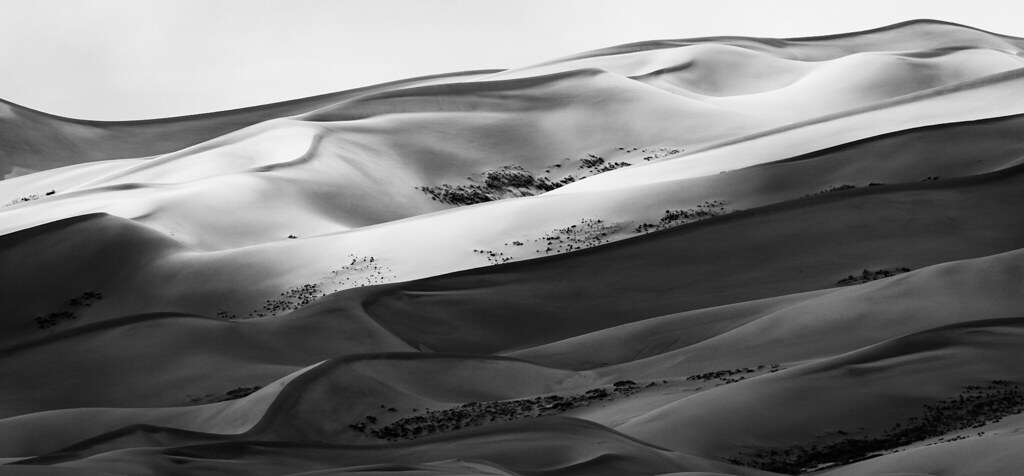
Photo: 420 Photography via Flickr (CC0 1.0 (Public Domain))
Great Sand Dunes National Park protects a landscape whose tallest dunes rise about 750 feet, yet the sand covers less than 12 percent of the park and preserve. The remaining acreage climbs into wetlands, grasslands, aspen groves, alpine tundra, and the 13,000-foot summits of the Sangre de Cristo Range. A three-day visit works best when it treats these environments as connected parts of one watershed rather than spending every daylight hour on exposed sand.
The park sits along the eastern edge of Colorado’s San Luis Valley, about 38 miles northeast of Alamosa. Wind carries sediment across the valley floor, while opposing storm winds push it back against the mountains. Medano and Sand creeks recycle escaping grains toward the main dunefield. Our itinerary follows that natural progression, beginning at the water and dune edge, devoting the coolest part of the second day to the high ridges, then moving into the foothills on day three.
How the Great Sand Dunes National Park 3-day itinerary fits together
Use the afternoon for orientation, not the hardest climb
Most travelers arrive after driving from Denver, Colorado Springs, or Albuquerque. Starting with High Dune or Star Dune immediately after a long drive creates two problems: afternoon sand can become dangerously hot in summer, and thunderstorms often build over the Sangre de Cristo Range. Day one instead uses the visitor center area, Medano Creek when it is flowing, and the lower dunes. These stops introduce the terrain without committing you to several hours on ridges where shade and marked trails do not exist.
Reserve the coolest morning for the dunefield
Day two begins near sunrise because loose sand makes every ascent slower than its map distance suggests. High Dune on First Ridge involves roughly 2.5 miles of travel, but climbing and sliding grains can make it feel considerably longer. The route gains close to 700 vertical feet from the dune base and provides a broad view of the main dunefield. Strong hikers can continue toward Star Dune, one of the tallest dunes in North America, using a longer route that demands careful navigation and substantially more water.
Finish where sand meets the mountains
The final day shifts toward the foothills. Short options such as the Montville Nature Trail reveal piñon and juniper woodland above the valley floor, while Mosca Pass Trail follows a wooded drainage toward the crest of the Sangre de Cristos. Zapata Falls, located south of the park on adjacent public land, also fits naturally on the departure day. This order avoids repeating the same landscape and leaves flexibility for tired legs, strong wind, or a change in weather.
Great Sand Dunes National Park: The Perfect 3-Day Itinerary at a glance
This plan assumes two nights near the park and arrival by early or mid afternoon. Piñon Flats Campground provides the shortest access to the dunes when it is operating, while lodging and other camping options are scattered near the park entrance and along the route toward Alamosa. Staying in Alamosa adds about 45 minutes of driving each way, but it provides the widest selection of groceries, fuel, and restaurants.
| Day | Main stop | Highlight | Approximate driving |
|---|---|---|---|
| 1 | Visitor center, Medano Creek, lower dunes | Orientation and sunset on the sand | Minimal driving after entering the park |
| 2 | Main dunefield | High Dune, with Star Dune as a strenuous extension | Minimal driving if staying near the entrance |
| 3 | Montville Trail, Mosca Pass, or Zapata Falls | Foothill ecology and a final mountain viewpoint | About 20 to 40 minutes between selected stops |
Reaching Great Sand Dunes National from regional gateways
Denver is approximately 235 road miles away, commonly requiring around four hours without lengthy stops. Colorado Springs is closer at about 165 miles, while Albuquerque is roughly 235 miles to the south. Alamosa is the practical supply point for all three approaches. Fill the fuel tank and buy trail food there because services become sparse east of Mosca, and mobile reception can weaken near the mountains. Download maps before leaving town rather than relying on live navigation around the park.
Separate essential stops from optional detours
The dune field, Medano Creek corridor, and one foothill trail form the core experience. Star Dune, Zapata Falls, and Medano Primitive Road require additional time or conditions. The primitive road crosses soft sand and Medano Creek repeatedly, so it is suitable only for high-clearance four-wheel-drive vehicles when open. Current fees, campground availability, road status, creek conditions, and seasonal services should be confirmed on the official park site before departure.
- Essential: Visitor center orientation, dune access from the main parking area, and an early morning ridge hike.
- Seasonal priority: Medano Creek during its spring and early summer flow.
- Optional strenuous objective: Star Dune for experienced hikers with enough daylight and water.
- Optional vehicle route: Medano Primitive Road in an appropriate vehicle and suitable conditions.
Day 1 at Great Sand Dunes National: Creek, sand, and sunset
Arrive prepared for an exposed landscape
Stop first at the visitor center area for a view across the dunefield and to assess clouds over the mountains. The main dune access begins near 8,200 feet in elevation, high enough for visitors arriving from lower elevations to notice shortness of breath. Carry water from the vehicle because the dunefield has no shade, maintained path, or dependable water source. In summer, the sand surface can reach about 150°F by afternoon, making closed shoes and a later start important.
Pack for sand, water, and rapid weather changes
A small daypack should hold at least a warm layer, rain shell, sun protection, water, and a light source. Wind can drive sand into exposed electronics, so use a sealed bag for cameras and phones. Trekking poles help on steep descents but baskets prevent them from sinking deeply. Sandboards and sand sleds have specialized bases; ordinary snow sleds, cardboard, and flexible plastic discs usually drag rather than glide on dry sand.
Walk Medano Creek before entering the dunes
From the main parking area, cross the broad creek bed toward the dune base. Flow is generally strongest from late spring into early summer, driven by mountain snowmelt, and it may disappear later in the year. When water and sand deposition align, small surges called wave flow move downstream at intervals. Bare feet are comfortable in shallow water, but shoes are useful where wind exposes coarse grains, pebbles, and cold channels.
Choose a low ridge for sunset
Climb one of the unnamed lower ridges rather than aiming for High Dune late in the day. Underfoot, each step presses into cool, loose sand and slides partway backward. Wind softens footprints within minutes. As the ridge narrows, the parking area drops from sight and the scale changes: repeated crests fill the foreground, the flat San Luis Valley opens to the west, and the Sangre de Cristo peaks rise abruptly behind the dunes. Descend before darkness erases the contours needed to retrace your route.
Day 2: Climb the dunes before the heat builds
Begin walking around sunrise, when the sand is firmest and the eastern faces remain cool. There are no constructed trails or signs beyond the creek crossing, so choose a prominent ridge and keep recognizable landmarks behind you. High Dune on First Ridge is the practical goal for most visitors. Its summit sits around 8,700 feet, with views toward Mount Herard, the Crestone group, and the closed basin of the San Luis Valley.
Follow ridgelines to High Dune
Directly climbing steep dune faces wastes energy because each step slips downhill. Use gentler shoulders to gain elevation, then follow narrow crests where the sand is slightly firmer. Allow two to three hours for the roughly 2.5-mile round trip, including time on the summit. Empty gullies can look identical from above, so periodically turn around and study the return route. If thunderheads begin forming over the mountains, descend immediately because the exposed ridges offer no shelter.
Decide whether Star Dune fits your ability
Star Dune requires about eight miles round trip from the main dune parking area when approached across the dunefield. The route has repeated elevation losses, soft sand, and no reliable trail, making total effort more important than mileage. Carry at least three liters of water per person in warm conditions and establish a turnaround time before leaving High Dune. Afterward, return to the same campground or lodging used on night one rather than adding a long evening drive.
Day 3: Trade open sand for shaded foothills
Start the final morning with a route that matches your remaining energy. The Montville Nature Trail and Mosca Pass Trail begin near the main visitor corridor, allowing a quick departure afterward. Zapata Falls works better for travelers continuing south or west through the San Luis Valley. Pack breakfast and lunch at your lodging because food choices near the trailheads are limited, then refuel in Alamosa before beginning a longer onward drive.
Choose Montville or Mosca Pass
The Montville Nature Trail forms a roughly half-mile loop through piñon pine and juniper, gaining enough height for a clear view over the dunefield. Its slopes also preserve traces of a late nineteenth-century settlement along Mosca Creek. For a longer finish, Mosca Pass Trail follows the drainage for about 3.5 miles each way and gains approximately 1,400 feet. Aspen stands and creekside vegetation provide more shade than the dunes, although the upper trail remains strenuous at elevation.
Add Zapata Falls when time allows
Zapata Falls lies south of the park, reached by a steep gravel access road from Colorado Highway 150. A short approach leads into a narrow rock chamber where cold water drops about 25 feet. Expect slippery stones and ankle-deep water when entering the slot, so keep dry footwear in the vehicle. The parking area also provides a broad western view of the dunefield. Allow about two hours for the detour, including the slow access-road drive and walk.
- Limited time: Complete Montville Nature Trail, then depart through Alamosa.
- Half day available: Hike part or all of Mosca Pass Trail.
- Southbound departure: Visit Zapata Falls before returning to Highway 150.
- Tired legs: Use the Montville overlook and skip the creek crossing at Zapata Falls.
Adjust the route for weather and season
Great Sand Dunes National conditions vary more by time of day than many first-time visitors expect. A calm morning can become windy by afternoon, while summer storms develop quickly against the Sangre de Cristo Range. Winter brings subzero nights, snow-covered dunes, and shorter daylight. Spring combines strong wind with cold creek water. Keep the three-day sequence, but move exposed hiking to the calmest forecast window rather than treating each day’s order as fixed.
Use seasonal conditions to set priorities
| Season | Likely conditions | Best itinerary adjustment |
|---|---|---|
| Spring | Frequent wind, cool nights, increasing creek flow | Hike dunes near sunrise and protect electronics from blowing sand |
| Summer | Hot sand, afternoon thunderstorms, early daylight | Finish exposed climbs before late morning |
| Autumn | Cooler sand, lower creek flow, freezing nights | Prioritize dune hiking and carry insulated layers |
| Winter | Snow, ice, severe wind chill, short days | Shorten routes and bring traction appropriate to conditions |
Prepare for the service gap
Carry a full tank, drinking water, meals, and an offline map before leaving Alamosa or another regional supply center. Cellular service becomes unreliable near the dune base, and navigation apps may suggest roads unsuitable for ordinary passenger vehicles. Store food securely at camp because black bears inhabit the foothills, while rodents and ravens readily investigate unattended supplies. A headlamp is essential for sunset walks, and a paper map provides a dependable backup when batteries or reception fail.
Build the perfect 3-day Great Sand Dunes National Park itinerary
This itinerary gives the coolest morning to High Dune, keeps the first afternoon manageable after arrival, and reserves the final day for foothill trails or Zapata Falls. Two nights in one location reduce packing and preserve early access to the dunefield. Travelers based in Alamosa gain more dining and supply options, while those staying near the entrance save driving time and can respond more easily to sunrise weather.
Keep Star Dune, Mosca Pass, and the primitive road optional. High wind, thunderstorms, altitude, and hot sand can change the sensible plan without diminishing the visit. With water, offline navigation, flexible objectives, and an early start, three days provide enough time to understand how creek, sand, valley, and mountains function as one connected Great Sand Dunes landscape.
Want to keep exploring? Browse all our Great Sand Dunes guides and articles for more trip-planning tips and ideas.
Gear & Essentials
Tell us about your trip and we will add what else you will want:
The basics
Worth having in the car whatever the park.
For this trip
Traveling with kids
Bringing a pet
RVing
Backcountry
Winter conditions
On the water
Photography
Accessibility
As an Amazon Associate we earn from qualifying purchases, at no extra cost to you.