A First-Timer’s Guide to Bryce Canyon National Park
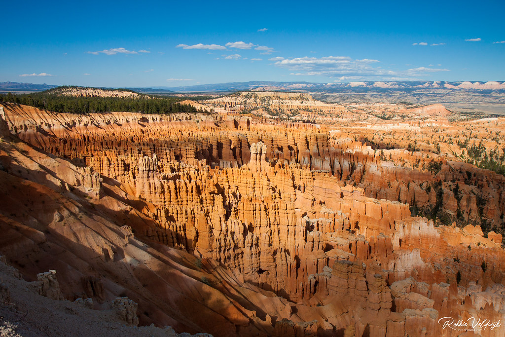
Photo: Unknown via Flickr (CC BY-NC-ND 2.0)
This First-Timer’s Guide to Bryce Canyon begins with the same problem every new visitor faces: you’ve seen the photos of those impossibly orange spires, and now you need to know how to actually visit one of the most geologically bizarre landscapes in North America. Bryce Canyon National Park sits on the eastern edge of the Paunsaugunt Plateau in southern Utah, at elevations ranging from roughly 8,000 feet at the park entrance to 9,115 feet at Rainbow Point, the highest stop on the 18-mile scenic drive. That elevation is not just a trivia detail. It shapes everything from the weather you’ll pack for to the
What most visitors don’t fully grasp before arriving is that Bryce Canyon is not actually a canyon in the geological sense. It is a series of natural amphitheaters carved into the edge of a plateau by frost-wedging and erosion, not by a river cutting downward through rock. Water seeps into cracks in the Claron Formation limestone, freezes, expands, and breaks the rock apart. This happens roughly 200 times per year at Bryce due to its elevation, which means freeze-thaw cycles are a near-daily occurrence in shoulder seasons. The result is a landscape of hoodoos, those narrow rock spires and columns that can stand anywhere from a few feet to over 200 feet tall, and which exist in higher concentration here than anywhere else on Earth.
A First-Timer's Guide to Bryce Canyon: Geography, Geology, and Getting There
Location and Driving Access
Bryce Canyon National Park is located in Garfield County, Utah, along Highway 12 and Highway 63. Most visitors approach from the north via US-89 through Kanab or Panguitch, then turn onto Highway 12 east toward the park entrance on Highway 63. From Las Vegas, the drive runs approximately 260 miles and takes around four hours under normal conditions. From Salt Lake City, plan on roughly 260 miles as well, but through a different route via I-15 south to US-89, taking about four and a half hours. Cedar City, about 80 miles southwest, is the closest city with a regional airport and serves as a practical base for travelers flying in.
The nearest towns with lodging, fuel, and groceries are Panguitch (about 25 miles north) and Tropic (about 11 miles east). Tropic sits at the base of the plateau and is worth noting because several backcountry trails in the park actually descend to the valley and could in theory be connected to Tropic with a car shuttle. The park entrance station is on Highway 63, approximately three miles south of Highway 12. From the entrance, the main visitor center is another mile south, and the most famous viewpoints (Sunrise, Sunset, Inspiration, and Bryce Point) are accessible within the first few miles of the scenic drive.
First-Timer's Guide to Bryce Canyon Terrain: What to Know Before You Arrive
The Paunsaugunt Plateau sits within the Grand Staircase, a sequence of colorful geological formations that step upward from the Grand Canyon in Arizona northward through southern Utah. Bryce sits at the top of that staircase, above the White Cliffs (Navajo Sandstone), Vermilion Cliffs (Moenkopi and Chinle formations), and Chocolate Cliffs (Moenkopi). The park’s defining rock, the Claron Formation, is a pale pink-to-red limestone and mudstone laid down in ancient lakes roughly 50 to 60 million years ago. Iron oxide gives the hoodoos their vivid red and orange tones; manganese oxide creates lavender and purple hues in some formations, particularly visible at Inspiration Point in the late afternoon.
The park’s full scenic drive runs 18 miles one-way from the visitor center to Rainbow Point, gaining roughly 1,100 feet in elevation as it travels south. The drive is entirely paved and accessible to standard passenger vehicles, though larger RVs and trailers have specific restrictions on some sections. Confirm current vehicle length limits and any seasonal road closures on the official park site before your trip.
A First-Timer’s Guide to Bryce Canyon: Seasons and Timing
How Each Season Changes the Experience
Bryce Canyon’s high elevation produces a climate unlike most desert parks. Summers are mild compared to the canyon parks at lower elevations, with afternoon highs in the mid-70s Fahrenheit at the rim, but afternoon thunderstorms are common from mid-July through early September, a weather pattern driven by the North American Monsoon. Winters bring substantial snowfall, averaging around 95 inches annually at the rim, and many visitors consider this the most spectacular time to see the hoodoos, when orange spires rise from a white snowpack under a blue sky. Spring and fall offer the most stable hiking conditions but can include rapid weather swings, including snowfall in May and September.
| Season | Typical Rim Temperatures | Crowds | Key Conditions |
|---|---|---|---|
| Spring (Apr-May) | 30s-60s F | Moderate, rising | Snow possible through May; wildflowers by late May |
| Summer (Jun-Aug) | 50s-75s F | Peak | Afternoon thunderstorms; shuttles in full operation |
| Fall (Sep-Oct) | 30s-65s F | Moderate | Clear skies; aspen color by mid-October |
| Winter (Nov-Mar) | 10s-40s F | Low | Heavy snow; snowshoe rentals available; most facilities reduced |
Why Sunrise and Sunset Are Practical, Not Just Scenic
Arriving at the rim viewpoints early in the morning accomplishes two things simultaneously. The low-angle light from the east, which hits the amphitheater directly at sunrise, produces the deep shadow contrast that makes hoodoo photography so striking. More practically, the park’s most popular viewpoints, including Sunrise Point, Sunset Point, and Inspiration Point, fill their parking areas by mid-morning during peak season. Arriving before 8 a.m. on a summer day virtually guarantees a parking spot and a quieter rim experience before the main wave of visitors arrives.
- Sunrise Point faces east-northeast and receives direct morning light from the moment the sun clears the horizon.
- Sunset Point, despite its name, is roughly 0.4 miles southwest of Sunrise Point along the Rim Trail and also offers excellent morning light because the amphitheater faces northeast overall.
- Inspiration Point sits at 8,100 feet and provides a higher vantage over a wider section of the Silent City, the densest cluster of hoodoos in the main amphitheater.
- Bryce Point, about 2.1 miles south of the visitor center by road, is the southernmost of the four major viewpoints in the main amphitheater and the highest at roughly 8,300 feet, giving a full panorama looking back north across the basin.
A First-Timer's Guide to Bryce Canyon Shuttle and Driving Strategy
During peak season, the park operates a free shuttle system connecting the town of Bryce (just outside the entrance) to the major viewpoints along the northern section of the scenic drive. The shuttle reduces traffic congestion significantly at the most popular stops and is often the fastest way to move between Sunrise Point, Sunset Point, Bryce Point, and the visitor center. For the southern section of the drive, including Natural Bridge, Agua Canyon, Ponderosa Canyon, and Rainbow Point, you’ll need your own vehicle since the shuttle does not extend that far south. Confirm current shuttle hours and routes
Interested in learning more? Explore our Grand Canyon National Park to Gradually Ease Water Conservation Measures Beginning April 17 to see how we can help bring your vision to life.