











Great Smoky Mountains National Park
Gregory Bald
| Type | Peak |
|---|---|
| Elevation | about 4,930 ft |
At a glance
- Place: Gregory Bald, a peak and grassy bald
- Park area: Above Cades Cove, Tennessee
- Elevation: About 4,930 feet
- Access: By trail only
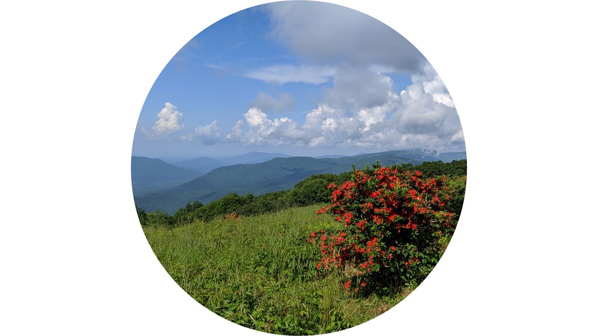
- Known for: Open views, photography, native plants, and flame azaleas
- Popular season: Mid-to-late June, especially late June
- Camping: Backcountry campsite #13 at Sheep Pen Gap is about 0.4 miles away
- Visitor center: Sugarlands Visitor Center is about 22 miles away
Why visit
Gregory Bald is one of the Smokies’ open balds managed by the National Park Service. Native grasses and heath cover its approximately 10-acre summit.
The bald is best known for native flame azaleas. Hybrid blooms range from yellow and orange to deep crimson during mid-to-late June. It is particularly popular in late June.
The open ground provides broad views across Cades Cove, surrounding country, the western Smokies, and Fontana Lake. It is also designated as a scenic viewpoint and photo location.
Getting there
Gregory Bald is reachable only by trail. Several routes begin around Cades Cove, while another approaches from Twentymile. Bring a map.
Cades Cove Loop Road provides access to routes from the cove. This one-way road covers 11 miles, with a typical completion time of 3–4 hours.
Route choices include:
- About 9.0 miles round trip on Gregory Bald Trail
- About 11.4 miles round trip on Gregory Ridge Trail
- About 14.2 miles round trip using Gregory Ridge Trail, Gregory Bald Trail, and Parson Branch Road
- About 17.5 miles round trip from Twentymile
The Twentymile loop combines Twentymile, the Appalachian Trail, Gregory Bald Trail, and Wolf Ridge Trail. The Cades Cove approaches by Gregory Ridge Trail and Parson Branch Road are strenuous.
Primary park roads operate 24 hours daily throughout the year when weather permits. These include Newfound Gap Road, Little River Road, and Laurel Creek Road. Secondary roads close seasonally.
Sugarlands Visitor Center is about 22 miles away. Gatlinburg is about 24 miles away, and Pigeon Forge is about 25 miles away. Cherokee is about 31 miles away. These are straight-line distances, not driving distances.
Air travelers may use McGhee Tyson Airport or Asheville Regional Airport.
What to see and do
The main experience is hiking to the open summit. From the bald, visitors can look across Cades Cove and the surrounding landscape. Views also extend toward the western Smokies and Fontana Lake.
Native flame azaleas provide the best-known seasonal display. Their hybrid flowers appear in shades from yellow through orange to deep crimson. The display usually occurs in mid-to-late June.
The summit is also a designated place for scenic views and photography. Native grasses and heath create an open foreground for photographs, especially during the azalea bloom.
Backcountry camping is available nearby at Sheep Pen Gap. It is identified as backcountry campsite #13 and lies about 0.4 miles from Gregory Bald.
History and nature
Gregory Bald has a distinctive grassy-bald ecosystem. Native grasses, sedges, ferns, blueberries, heath, and flame azaleas grow across its open summit.
Research indicates that large animals may once have kept grassy balds free of encroaching vegetation. Early grazers may have included mastodons or woolly mammoths. Bison, elk, and deer may have continued that role later.
Today, the National Park Service preserves the open character of Gregory Bald. Periodic mowing and brush removal prevent woody growth from overtaking the roughly 10-acre summit.
Gregory Bald is one of the park’s maintained grassy balds. Andrews Bald is another. Silers Bald is also identified as a similar point of interest.
When to go
Mid-to-late June is the principal season for flame azaleas. Late June is especially popular with hikers seeking the bloom.
Conditions can differ sharply between the lower valleys and Gregory Bald. Park elevations range from about 875 feet to 6,643 feet, and terrain strongly influences local weather.
Temperatures may change by 10–20 degrees Fahrenheit between a mountain’s base and summit. Clear weather at lower elevations does not ensure pleasant conditions higher up.
Primary roads remain open year-round when weather allows, but secondary roads have seasonal closures. Check current road, trail, and weather conditions before selecting a route.
Accessibility
Gregory Bald has no road access and can be reached only by trail. Available routes range from about 9.0 to 17.5 miles round trip.
The approaches from Cades Cove by Gregory Ridge Trail and Parson Branch Road are strenuous. Visitors should choose a route suited to their abilities and carry a map.
Fees and rules
No Gregory Bald fee information is provided. Follow all posted park and backcountry rules.
Camping near the bald is available at designated backcountry campsite #13 in Sheep Pen Gap. Confirm current requirements and campsite availability through the park before leaving.
Stay on established routes, protect the bald’s native vegetation, and leave no trace. Do not disturb the flame azaleas or other plants.
Nearby trails and places
Gregory Ridge Trail is about 0.7 miles away and measures about 4.9 miles as mapped. Gregory Bald Trail is about 0.7 miles away and measures about 7.2 miles as mapped.
Long Hungry Ridge Trail is also about 0.7 miles away. It measures about 4.5 miles as mapped.
Other nearby features include:
- #13 Sheep Pen Gap campsite, about 0.4 miles away
- Panther Gap, about 0.5 miles away
- Sheep Pen Gap, about 0.5 miles away
- Gregorys Little Bald, about 0.6 miles away
- Rich Gap, about 0.7 miles away
- High Point, about 0.8 miles away
Andrews Bald and Silers Bald are similar points of interest elsewhere in the park.
Before you go
Bring a map for any route to Gregory Bald. Carry water, pack layers, and prepare for changing weather between the valleys and summit.
Check current conditions, road closures, trail notices, campsite requirements, and park alerts on the National Park Service website. Follow posted rules and leave no trace.
Questions
How high is Gregory Bald?
Gregory Bald is about 4,930 feet above sea level.
Can you drive to Gregory Bald?
No. Gregory Bald is accessible only by trail.
How long is the hike to Gregory Bald?
Listed round trips range from about 9.0 miles to 17.5 miles, depending on the route.
When do flame azaleas bloom on Gregory Bald?
They bloom in mid-to-late June, with late June being especially popular.
What can you see from Gregory Bald?
Views include Cades Cove, surrounding areas, the western Smokies, and Fontana Lake.
Can you camp near Gregory Bald?
Yes. Backcountry campsite #13 at Sheep Pen Gap is about 0.4 miles away.
What plants grow on Gregory Bald?
The bald supports flame azaleas, native grasses, sedges, ferns, blueberries, and heath.
Which trails reach Gregory Bald?
Routes use Gregory Bald Trail, Gregory Ridge Trail, or a Twentymile loop with the Appalachian Trail and Wolf Ridge Trail.
Nearby
Places
- #13 Sheep Pen Gap
- Panther Gap
- Sheep Pen Gap
- Gregorys Little Bald
- Rich Gap
- High Point
On the map
1 trail16 places to see4 visitor services
Facts on this page draw on the National Park Service: Gregory Bald (nps.gov)