Theodore Roosevelt National Park
Best Things to Do in Theodore Roosevelt National Park Beyond the Scenic Drive
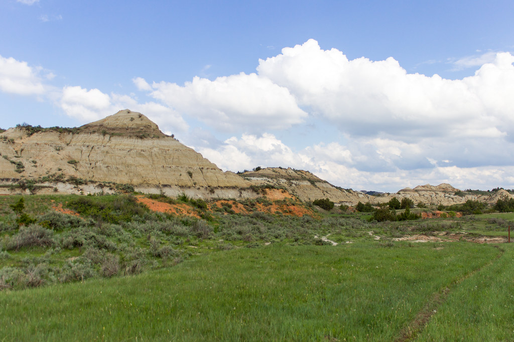
Photo: Matt-Zimmerman via Flickr (CC BY 2.0)
The Best Things to Do in Theodore Roosevelt National Park begin once you park the car and walk into the badlands: climb a butte above the Little Missouri River, follow a prairie dog town trail, visit Theodore Roosevelt’s remote Elkhorn Ranch site, and give yourself time in both the South and North Units. The park’s scenic drives provide useful access, but its short trails, open prairie, wildlife pullouts, and historic landscape explain why this broken country shaped Roosevelt’s conservation ethic.
Our team recommends treating the park as a two or three day western North Dakota route rather than a quick Medora stop. The South Unit has the most convenient services and the largest concentration of first time visitor stops. The North Unit, about 70 road miles north near Watford City, is quieter, steeper in places, and better suited to hikers who want longer views over the Little Missouri Badlands. Elkhorn Ranch lies between the units on a separate backroad approach, making it a logical dedicated stop rather than an afterthought.
Plan the park around its three separated units
Start in Medora and use the South Unit as your base
Medora sits immediately outside the South Unit entrance and is the practical place to begin. The town is about 30 minutes west of Dickinson via Interstate 94, and its proximity lets visitors enter early, return for meals, and avoid driving unfamiliar roads after dark. The South Unit’s 36 mile Scenic Loop Drive reaches overlooks, trailheads, the Painted Canyon area near Interstate 94, and prairie dog colonies, but the road is only the framework for a day of walking and stopping.
Build your first day around the southern badlands because its trails show the park’s core geology at close range. Bentonite clay, sandstone, lignite coal seams, and siltstone erode at different rates, creating the park’s layered buttes and pale gray slopes. These formations were deposited in swampy floodplains roughly 55 to 65 million years ago, after the age of dinosaurs. Look closely at exposed dark bands, which often mark lignite, a low grade coal formed from ancient vegetation.
Use the North Unit for bigger overlooks and a quieter second day
The North Unit entrance is south of Watford City, reached by a separate road network from the South Unit. It is not practical as a same afternoon add on from Medora if you want time on trail. Plan to sleep in Watford City, camp near the unit if you have secured a site, or make the drive from Medora only if you are comfortable committing most of the day to travel and hiking. The 14 mile North Unit Scenic Drive ends at Oxbow Overlook, above a broad bend in the Little Missouri River.
The North Unit contains more pronounced relief than many South Unit stops. Trails climb from grasslands cut by coulees toward viewpoints where the river winds through cottonwood bottoms below. It is also a good place to look for bison, elk, mule deer, wild horses, golden eagles, and prairie dogs. Wildlife frequently crosses roads and moves most actively around dawn and dusk, so drive slowly and leave generous space. Bison can cover ground rapidly, especially around calves or during the autumn rut.
Make Elkhorn Ranch a separate historic stop
Theodore Roosevelt ran the Elkhorn Ranch from 1884 to 1887, after personal losses drew him back to the Dakota Territory. The ranch house is gone, but its site on a quiet Little Missouri River bottom remains the most direct connection to Roosevelt’s working ranch years. A short path leads from the parking area to interpretive markers and the house foundation area. The setting is deliberately spare, with cottonwoods, grassland, river bottom vegetation, and badland ridges forming the view that Roosevelt knew.
Road access to Elkhorn Ranch involves unpaved routes that can become deeply rutted or impassable after rain or snowmelt. A high clearance vehicle is useful, and travelers should carry a paper map or downloaded navigation because cellular service is unreliable in the backcountry. Fuel up in Medora or Watford City, keep drinking water in the vehicle, and check road conditions before committing to the drive. Entrance arrangements, road status, and seasonal access should be confirmed on the official park site.
A practical two day route beyond the scenic drives
Day one combines South Unit overlooks with short walks
Enter the South Unit early and use the loop road to connect a series of short hikes rather than stopping only at signed overlooks. Begin with Wind Canyon Trail while temperatures are low, then continue toward Buck Hill and the Coal Vein area. These walks are short enough to fit around wildlife viewing but reveal distinct pieces of the park: a river cut, a high prairie ridge, and the legacy of underground coal fires. Return to Medora for the night, where food and lodging choices are concentrated.
Day two moves north for river country and longer trails
Drive to the North Unit in the morning, allowing time for the transfer before hiking. Choose one trail that descends into a coulee or climbs toward a river viewpoint, then finish at Oxbow Overlook. This order works because the overlook is most useful as a late day orientation point after you have spent time within the folded terrain below. If your schedule includes Elkhorn Ranch, add a third day or substitute it for the North Unit, rather than compressing both into one rushed itinerary.
| Day | Stop | Highlight | Approximate drive time |
|---|---|---|---|
| Day 1 | Medora and South Unit | Wind Canyon, Buck Hill, Coal Vein, prairie dog towns | About 5 minutes from Medora to the entrance |
| Day 2 | North Unit near Watford City | Caprock Coulee, Sperati Point, Oxbow Overlook | About 1 hour 45 minutes from Medora |
| Day 3, optional | Elkhorn Ranch | Roosevelt ranch site and Little Missouri bottomland | Allow several hours because of unpaved access roads |
Walk the South Unit’s most useful trails
Choose Wind Canyon for the clearest Little Missouri view
Wind Canyon Trail is a 0.4 mile out and back walk ending on a bluff above the Little Missouri River. It is short, exposed, and especially worthwhile near sunset, when low light emphasizes the ridges and gullies across the valley. The trail is a smart first walk for families and for visitors who have limited time, but the bluff edge demands attention in wind and rain. Stay on the established path because badland clay becomes slick when wet and breaks easily under repeated foot traffic.
At the overlook, the ground underfoot is dry grass and crumbly pale soil, while the river sits far below in a band of cottonwoods. Wind moves across the open bench with little obstruction, carrying the sound of meadowlarks and, at times, distant traffic from the road. The view is broad rather than vertical: the Little Missouri curves through a low valley, and beyond it the badlands rise in uneven terraces stained tan, gray, rust, and black by different rock layers.
Climb Buck Hill for the South Unit’s highest viewpoint
Buck Hill Trail is a short but steep 0.8 mile loop that reaches the South Unit’s highest point at about 2,855 feet. The elevation gain is modest in mountain terms, yet the exposed slope and summer heat make the climb more demanding than its mileage suggests. From the summit, visitors can see the park’s mixed grass prairie spreading beyond the eroded buttes. This is one of the best places to understand that the badlands are islands of broken ground within a much larger Great Plains landscape.
Pair Coal Vein Trail with an understanding of the landscape
Coal Vein Trail is an 0.8 mile loop with interpretive exhibits explaining a coal seam that burned underground for decades after igniting in the 1950s. The fire altered soils, baked surrounding rock, and left visible evidence of the region’s combustible lignite deposits. This easy walk is particularly useful for visitors who want geological context before tackling longer trails. It also demonstrates why the park’s colors vary so sharply: iron minerals, burned sediments, coal, and weathered clay each contribute different tones.
Reserve Petrified Forest for a longer South Unit hike
The Petrified Forest Loop is roughly 3 miles and crosses rolling terrain to concentrations of fossilized tree stumps. It is accessed from a trailhead outside the main South Unit loop, so it needs deliberate planning and extra water. The petrified wood comes from trees buried by sediment, then gradually replaced by minerals over millions of years. Hikers should expect limited shade, uneven footing, and stronger exposure to wind than the short roadside trails. Carry more water than you expect to need, plus sun protection and a downloaded map.
- Start exposed trails early in summer, when afternoon temperatures can climb quickly.
- Wear shoes with traction for bentonite clay, especially after rain.
- Carry at least two liters of water per person for longer walks.
- Keep at least 25 yards from bison, wild horses, and elk, and much farther if an animal changes its behavior.
- Download maps before entering either unit because service drops in coulees and along backroads.
Give the North Unit enough time to earn the drive
Hike Caprock Coulee for badland texture at walking pace
Caprock Coulee Trail is a 1.5 mile loop that descends through a coulee beneath layered caprock formations. It is among the most efficient North Unit hikes because it moves quickly from open grassland into eroded terrain where each turn reveals a different wall, drainage, or slope. Watch for prickly pear cactus on dry ground and juniper in sheltered draws. After rain, clay sections can be slick enough to change a straightforward loop into a slow, muddy walk.
Walk to Sperati Point for a river overlook
Sperati Point Trail is about 1.5 miles round trip and leads to a high viewpoint over the Little Missouri River. The route is relatively gentle but fully exposed, so wind and sun are the main factors. The point is named for A. G. Sperati, a local rancher associated with the area’s early settlement history. From the end, look downriver for the contrast between the green cottonwood corridor and the dry uplands, a pattern that shapes where wildlife finds water, shelter, and forage.
Save Oxbow Overlook for the end of the day
Oxbow Overlook sits at the end of the North Unit drive and looks down on one of the Little Missouri River’s broad bends. Use it as a final stop after hiking, then scan the slopes and river bottom with binoculars for deer, bison, or raptors riding thermals. The overlook also clarifies the park’s scale: the river has cut laterally through soft sedimentary rock, leaving ridges and isolated buttes above a floodplain that still shifts with seasonal water.
Use a Third Day for History, Wildlife, or a Slower Pace
Make Elkhorn Ranch the priority extension
For most travelers, Elkhorn Ranch is the most meaningful addition to a two day park visit because it explains Theodore Roosevelt’s connection to this landscape better than any overlook can. Allow the day to remain flexible: unpaved approaches demand more time than their map mileage suggests, and wet clay can make travel impractical. Plan the ranch visit in daylight, bring food and water from Medora or Watford City, and leave enough margin to turn back if road conditions deteriorate.
The historic site works best for visitors who have already walked among the badlands. After seeing the exposed coal seams, dry draws, and Little Missouri overlooks, the quiet river bottom gives Roosevelt’s ranching years a clearer setting. The foundation markers identify where the Elkhorn Ranch house stood, but the important context is the distance from town, the shelter of the cottonwoods, and the open grazing country beyond the river.
Prioritize the stops that match your available time
Visitors with one full day should focus on the South Unit and choose two or three walks rather than attempting every pullout. Wind Canyon and Buck Hill provide distinct views with little mileage, while Coal Vein Trail adds useful geologic context. A second day belongs to the North Unit, where Caprock Coulee and Sperati Point give the drive a purpose beyond reaching Oxbow Overlook.
Optional detours work best after those core stops are complete. The Petrified Forest Loop is a worthwhile addition for hikers interested in fossil wood and open prairie terrain. Painted Canyon, near Interstate 94, is useful as an arrival or departure stop because it offers a broad introduction to the badlands without requiring time on the South Unit loop. The best things to do in Theodore Roosevelt National Park come from combining one elevated viewpoint, one trail within a coulee, and time to watch the prairie quietly.
A practical packing list for the three unit route
- Full fuel tank before leaving Medora or Watford City, especially for Elkhorn Ranch access roads.
- Downloaded maps for both park units and the ranch approach.
- Binoculars for scanning river bottoms, grasslands, and distant ridges without approaching wildlife.
- Two liters of water per person for longer walks, plus salty snacks for hot days.
- A rain shell and extra layer, since wind can lower the apparent temperature quickly on exposed overlooks.
- A basic tire kit and spare tire in good condition for unpaved roads.
Match the Route to North Dakota’s Seasons
Summer rewards early starts and long daylight
June through August brings the longest days, green grass in wetter years, and active prairie wildlife, but it also brings heat, thunderstorms, and little shade on trail. Start longer hikes in the morning, especially Buck Hill, Petrified Forest, Caprock Coulee, and Sperati Point. Afternoon storms can develop quickly across the plains, and exposed ridges are poor places to wait through lightning. Return to your vehicle at the first sound of thunder rather than trying to finish a loop.
Summer is also the season when bison calves, prairie dogs, and grassland birds are easiest to notice. Watch road edges at low speed, particularly near prairie dog towns and water sources. Do not stop in the travel lane for animals. Pull fully into a designated turnout, use binoculars, and give wildlife enough room to continue feeding or crossing without reacting to your presence.
Fall and spring change the pace of the trip
September often brings cooler hiking weather and clearer visibility across the badlands, although autumn is also the bison rut. Bulls can become more aggressive during this period, so distance matters even more than usual. Spring brings green growth, muddy trails, and the possibility of snow or rain affecting backroads. It is a productive season for birding in cottonwood draws, where migratory species use the river corridor.
Winter travel is best for visitors prepared for cold, wind, snow packed roads, and reduced daylight. The park’s open grasslands provide few windbreaks, making conditions feel colder than the thermometer suggests. South Unit stops closest to Medora are the most practical winter option, while travel to the North Unit or Elkhorn Ranch needs extra caution. Carry warm layers, food, water, a charged phone, and winter vehicle supplies before leaving town.
| Season | Best route emphasis | Conditions to plan for | Useful adjustment |
|---|---|---|---|
| Spring | South Unit trails and wildlife viewing | Mud, wind, changing temperatures | Keep Elkhorn Ranch flexible |
| Summer | Two unit hiking itinerary | Heat, thunderstorms, exposed trails | Hike early and reserve afternoons for overlooks |
| Fall | North Unit viewpoints and longer walks | Cooler temperatures, bison rut | Maintain large wildlife distances |
| Winter | South Unit access near Medora | Ice, snow, severe wind, short days | Limit driving and carry winter emergency gear |
Handle Food, Fuel, and Connectivity Before Leaving Town
Stock up in Medora or Watford City
Medora is the natural supply point for the South Unit, while Watford City serves the North Unit. Buy drinking water, trail food, and fuel before entering the park because there are no commercial services inside the units. Travelers sleeping in Medora can use the town as a base for an early South Unit start, then relocate north after the first day if they want more time around Watford City and the North Unit.
Food planning matters most on the transfer day. The drive between the two units uses public highways rather than a connecting park road, and stopping for a substantial meal before hiking prevents a late afternoon scramble. Pack a cooler if your itinerary includes Elkhorn Ranch, since the ranch site is remote and should not be treated as a quick stop between restaurant meals.
Expect service gaps in the places that need navigation most
Cell coverage can fade in coulees, low river terrain, and along unpaved routes approaching Elkhorn Ranch. Download maps while connected, save your lodging address, and tell someone your route if you plan to travel backroads alone. A paper North Dakota road map remains useful because it shows the larger highway network when a navigation app loses its location or tries to route around an impassable road.
Choose lodging based on the next morning’s first stop, not only on price. Medora minimizes travel time for South Unit dawn wildlife viewing and evening walks near Wind Canyon. Watford City makes the North Unit more convenient and avoids repeating a long transfer drive. Campers should prepare for wind, variable temperatures, and limited shade, then check the park’s official website for current campground availability, entrance pass requirements, and reservation rules.
Frequently Asked Questions
How many days do you need at Theodore Roosevelt National Park?
Two full days cover the South Unit and North Unit at a useful pace. Add a third day for Elkhorn Ranch, Petrified Forest, or additional wildlife viewing without compressing the route.
Can you visit Theodore Roosevelt National Park with kids?
Yes. Wind Canyon, Coal Vein, Buck Hill, and Caprock Coulee provide short walks with varied terrain, though children need close supervision near bluff edges and around wildlife. Carry water because shade is limited on nearly every trail.
Are dogs allowed on trails in Theodore Roosevelt National Park?
Pets are generally allowed in developed areas and along roadways when leashed, but they are not permitted on park trails or in the backcountry. This protects wildlife and prevents pets from encountering bison, prairie dogs, rattlesnakes, or other hazards.
Do you need a reservation to enter the park?
An entrance pass is required, while reservation and camping arrangements can change. Check the official Theodore Roosevelt National Park website before departure for current entry, camping, and backcountry permit details.
Is the park open in winter?
The park remains a year round destination, but snow, ice, wind, and road conditions can substantially limit travel. The South Unit near Medora is usually the simplest winter choice because services are closer and the route is easier to shorten.
Build Your Visit Around Time Outside the Vehicle
Theodore Roosevelt National Park rewards travelers who use the roads as access rather than as the main event. A two day plan centered on the South Unit’s short walks and the North Unit’s river overlooks gives each landscape enough time to register. Add Elkhorn Ranch when road conditions and your schedule allow, particularly if Roosevelt’s ranching history is a major reason for the trip.
Start with the trail that fits the weather, keep fuel and water margins generous, and let wildlife sightings slow the itinerary rather than derail it. From the Little Missouri below Wind Canyon to the river bend at Oxbow Overlook, the park makes most sense at walking pace, where its coal seams, clay slopes, prairie grass, and cottonwood bottoms become part of the route instead of scenery passing beyond the windshield.
Want to keep exploring? Browse all our Theodore Roosevelt guides and articles for more trip-planning tips and ideas.
Gear & Essentials
Tell us about your trip and we will add what else you will want:
The basics
Worth having in the car whatever the park.
For this trip
As an Amazon Associate we earn from qualifying purchases, at no extra cost to you.