Theodore Roosevelt National Park
Theodore Roosevelt National Park Travel Guide: Scenic Drives, Wildlife, and Hiking Trails
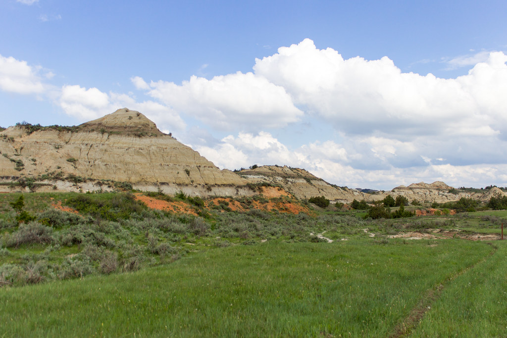
Photo: Matt-Zimmerman via Flickr (CC BY 2.0)
Our Theodore Roosevelt National Park Travel Guide starts with a useful surprise: the park has three separate units, and no road connects them inside the boundary. The South Unit, North Unit, and Elkhorn Ranch Unit protect different stretches of western North Dakota badlands, with the Little Missouri River winding through the larger units. Travelers who treat them as adjacent attractions can lose several hours retracing highways and gravel roads.
The South Unit beside Medora has the busiest entrance, the greatest concentration of short trails, and the easiest access from Interstate 94. The quieter North Unit lies about 70 road miles away, near Watford City, while Elkhorn Ranch preserves the remote site where Theodore Roosevelt ranched in the 1880s. Most first visits work best with one full day in the South Unit, followed by a separate day for the North Unit.
Understanding the park before choosing a trail
Water and wind cut these badlands into buttes, gullies, benches, and rounded clay slopes. Horizontal bands record ancient floodplains and forests, while dark lignite seams formed from compressed vegetation. Some seams burned underground, baking nearby sediment into reddish clinker locally called scoria. That hard material caps ridges and appears underfoot on trails such as Buck Hill and sections of Caprock Coulee.
South Unit, Painted Canyon, and Elkhorn Ranch
The South Unit entrance sits in Medora, making it practical for sunrise wildlife drives and evening walks. Painted Canyon, reached separately from Interstate 94 at Exit 32, overlooks a broad maze of striped buttes and has its own trail access. Elkhorn Ranch requires a much longer approach over unpaved roads. The ranch site has few visible structural remains, so it rewards visitors interested in Roosevelt’s history and the isolation of the Little Missouri valley rather than developed attractions.
North Unit terrain and scale
The North Unit feels more enclosed near the river and more expansive along the rim. Its road climbs from cottonwood bottomland to overlooks above deeply eroded badlands. Caprock Coulee provides the unit’s strongest half-day hike, while Sperati Point follows gentler prairie toward a broad river bend. Bison, mule deer, and feral horses occur in the park, although the horses are primarily associated with the South Unit. Prairie dog towns support badgers, coyotes, burrowing owls, and black-footed ferrets, which were reintroduced to the region.
Scenic roads that double as wildlife routes
Driving is central to understanding the park because each road moves between river habitat, open prairie, and exposed badlands. Bison often use pavement as an easy travel corridor, and a stopped herd can delay traffic considerably. Remain inside the vehicle when animals occupy the road, leave generous space, and never attempt to force a passage. Dawn and the final two hours before sunset generally produce the most wildlife activity and the least heat shimmer.
The South Unit’s changing loop road
The South Unit road was designed as a 36 mile scenic loop, but erosion and construction have periodically converted portions into an out-and-back drive. Key stops include Skyline Vista, Buck Hill, Boicourt Overlook, and the Wind Canyon trailhead. Prairie dog towns near the road attract frequent attention, while the higher overlooks reveal the Little Missouri’s bends and wooded floodplain. Allow at least two hours for the drive, and considerably longer if combining it with short hikes.
Wind Canyon at river level
On the 0.4 mile Wind Canyon Trail, compacted dirt and exposed rock rise quickly from the roadside toward an open rim. Wind carries through the grass, cottonwood leaves flicker below, and the muddy Little Missouri appears around the final bend with badland walls stacked beyond it. The trail is short, but its sloping edges and polished rock require deliberate footing. Late afternoon light reaches into the river corridor, making this a useful final stop before leaving the unit.
The North Unit road to Oxbow Overlook
The North Unit Scenic Drive runs approximately 14 miles from the entrance to Oxbow Overlook, making the return journey about 28 miles. River Bend Overlook, with its Civilian Conservation Corps stone shelter, provides the clearest elevated view into the Little Missouri valley. Farther west, the road crosses exposed ridges before ending above a large river meander. Bison commonly graze near the road, while bighorn sheep are occasionally visible on steep, broken slopes.
Choosing a Theodore Roosevelt hiking route
Trail mileage can be deceptive here. Clay becomes adhesive when wet, exposed ridges provide little shade, and repeated descents into coulees add effort without producing large elevation totals. Short nature trails suit travelers working around a scenic drive, while Caprock Coulee and Petrified Forest require sustained route finding and weather awareness. The comparison below uses commonly published distances, but signed routes and temporary closures should govern decisions on the ground.
| Trail | Unit | Distance | Difficulty | Primary feature |
|---|---|---|---|---|
| Wind Canyon Trail | South | 0.4 mile loop | Easy to moderate | Little Missouri overlook |
| Buck Hill Trail | South | 0.2 mile round trip | Moderate, steep finish | High badlands viewpoint |
| Painted Canyon Nature Trail | South vicinity | 1 mile loop | Moderate | Close views of layered buttes |
| Caprock Coulee Loop | North | 4.3 miles | Moderate to strenuous | Coulees, ridges, and river views |
| Sperati Point Trail | North | 2.4 miles round trip | Moderate | Prairie and river bend overlook |
| Petrified Forest Loop | South | About 10 miles | Strenuous | Petrified wood and backcountry prairie |
Short walks with immediate viewpoints
Buck Hill reaches one of the South Unit’s highest accessible viewpoints, near 2,850 feet, after a very short but steep climb from the parking area. Painted Canyon Nature Trail descends from the rim, so the return climb is harder than the opening section suggests. Wind Canyon has less elevation change but includes exposed edges. These routes can be combined in one day, provided summer thunderstorms or wet bentonite clay have not made the surfaces unsafe.
Longer routes for half-day and full-day hikes
Caprock Coulee begins with badland formations and wooded drainage before climbing onto open prairie. The upper section is exposed to wind, sun, and lightning, with broad views toward the Little Missouri. Petrified Forest is a longer backcountry undertaking reached from outside the main scenic road. Its fossilized tree remnants lie scattered across open terrain rather than concentrated in a developed display, and limited shade makes an early start important from late spring through early autumn.
Trailhead access, timing, and essential gear
Parking areas at Wind Canyon, Buck Hill, and major overlooks are relatively small and can fill around sunset or during summer weekends. Painted Canyon has separate interstate access, while the Petrified Forest trailhead requires several miles of gravel road that can become difficult after heavy rain. Entrance fees, road status, backcountry requirements, and seasonal services can change, so confirm current details on the official park site before setting out.
Conditions by season
May and June usually bring greener prairie, flowering plants, and cool mornings, but rain can turn clay trails into heavy mud. July and August often produce temperatures above 90 degrees Fahrenheit, exposed hiking, and afternoon thunderstorms. September typically offers cooler walking conditions and active wildlife. Winter brings low temperatures, strong wind, snow, and ice, while some roads or facilities may have reduced access. Spring thaw is especially damaging to unpaved roads and trail surfaces.
What belongs in a badlands day pack
- Water: Carry at least two liters per person for a moderate half-day hike, with more for exposed summer routes.
- Sun protection: Use a brimmed hat, sunscreen, sunglasses, and light long sleeves because most ridge trails have no dependable shade.
- Footwear: Choose shoes with pronounced tread. Dry clay can be loose, while wet clay clings to soles and removes traction.
- Navigation: Download an offline map and carry a paper backup for Petrified Forest and other backcountry routes.
- Weather layer: Pack a windproof outer layer because exposed rims can be much cooler than sheltered coulees.
- Wildlife distance: Bring binoculars so bison, bighorn sheep, prairie dogs, and nesting birds can be observed without approaching them.
How to hike Caprock Coulee safely
The Caprock Coulee trailhead sits beside the North Unit Scenic Drive, with limited roadside parking and little room for oversized vehicles. Starting early reduces parking pressure and keeps the exposed ridge portion out of the hottest part of the day. Follow the loop in the signed direction and photograph the trail map before leaving. Several intersecting paths, including the Buckhorn Trail, extend into the backcountry, so an accidental turn can add substantial mileage.
From the coulee floor to the caprock
The opening section enters a drainage where juniper, ash, and shrubs provide intermittent shade. The grade increases as the route climbs through bentonite slopes and harder sandstone ledges. Footing becomes loose near the caprock formations, and wet clay can make the climb impractical. After gaining the prairie bench, the trail becomes less steep but more exposed. Plan on roughly 600 feet of cumulative elevation gain across the complete loop.
| Trail phase | Typical terrain | Physical demand | Main concern |
|---|---|---|---|
| Lower coulee | Drainage, shrubs, eroded clay | Gradual climbing | Mud after rain |
| Caprock ascent | Rock ledges and loose slopes | Steepest portion | Unstable footing |
| Prairie bench | Open grassland | Moderate rolling grades | Sun, wind, and lightning |
| Return descent | Badland ridges and drainage | Sustained downhill walking | Slippery clay and tired legs |
Managing weather and wildlife
Turn back if thunder begins while you are on the upper prairie because the route offers no reliable shelter from lightning. Bison may also occupy the trail or the surrounding grassland. Give them at least 25 yards, and increase that distance if an animal faces you, raises its tail, paws the ground, or stops grazing. Backtracking is safer than attempting to squeeze between a bison and a steep slope.
Planning the longer backcountry routes
Petrified Forest requires a different approach from the roadside trails covered earlier in this Theodore Roosevelt National Park Travel Guide. The route crosses broad prairie where bison paths can appear more distinct than the maintained trail. Petrified logs and stumps occur in separate concentrations, and the complete loop demands a long, exposed day. Carry enough water to finish without relying on the Little Missouri River, stock ponds, or seasonal drainages.
Navigation beyond the developed corridor
Download the correct park map before leaving Medora because cellular service becomes unreliable near remote trailheads. At every junction, compare the trail direction with surrounding ridges rather than following footprints. Wind can erase tracks, while grazing animals create convincing side paths. A GPS track is useful, but a paper map and compass remain important if heat, cold, or battery loss disables a phone.
Backcountry camping and low impact travel
Day hikers generally do not need a separate hiking permit, while overnight backcountry travel requires authorization from the park. Camp away from trails, water sources, and archaeological remains according to the current permit conditions. Fires are generally inappropriate in this dry, windy landscape, so backpackers should plan around a stove and any active fire restrictions.
- Pack all food scraps, tissues, and hygiene products out of the backcountry.
- Leave petrified wood, fossils, antlers, stones, and historic objects where they are found.
- Carry extra water in rigid or abrasion resistant containers because thorny vegetation can damage thin reservoirs.
- Check boot soles and tent fabric for clay before it dries into a heavy, difficult layer.
- Store food securely and never leave packs where bison or rodents can investigate them.
Frequently Asked Questions
Mobile coverage is inconsistent in both main units and especially weak around Elkhorn Ranch and remote South Unit trailheads. Save maps, emergency contacts, and vehicle directions offline. Tell someone which unit and trail you selected, since reporting only the park name leaves rescuers with an enormous search area. Fuel, food, and replacement hiking equipment are easiest to obtain before entering the longer gravel approaches.
Road closures can alter access without closing an entire unit. Bentonite surfaces become slick during rain, while unpaved approaches can remain soft afterward even when nearby pavement is dry. A passenger car can reach many trailheads in favorable conditions, but low clearance becomes a concern after erosion or washouts. Avoid driving around barriers because shoulders may conceal saturated clay or damaged culverts.
Do I need a reservation to enter the park?
A general timed entry reservation has not traditionally been required. Visitors still need an entrance pass, and overnight backcountry use requires a permit. Check the park’s official website for current fees and reservation rules.
Are dogs allowed on hiking trails?
Pets are prohibited on park trails and in the backcountry. They are generally limited to roads, developed areas, and other specifically designated locations, and they must remain under physical control.
How many days should I spend in Theodore Roosevelt National Park?
Two full days allow one day for the South Unit and another for the North Unit. Add a third day for Petrified Forest, Elkhorn Ranch, or a longer wildlife focused visit.
Are the trails suitable for children?
Wind Canyon and other short developed trails suit many families when adults supervise exposed edges. Caprock Coulee is better for children comfortable with several hours of hiking, steep grades, heat, and close wildlife awareness.
Can I hike after heavy rain?
Wait until clay surfaces dry. Wet bentonite sticks to footwear, eliminates traction, damages trails, and can strand vehicles on unpaved access roads.
Building a practical badlands itinerary
A successful visit starts by treating the North and South units as separate day trips. Pair short South Unit walks with wildlife stops and changing light along the scenic road. Reserve the North Unit for River Bend Overlook, Oxbow Overlook, and Caprock Coulee. Begin long hikes early, carry all required water, and keep enough time available for bison delays or a cautious retreat from thunderstorms.
The park rewards flexible planning because weather and wildlife frequently control the pace. Choose routes according to surface conditions rather than mileage alone, and avoid packing remote trailheads into the same day as a long interunit drive. With offline navigation, proper footwear, sun protection, and realistic turnaround points, visitors can explore the Little Missouri badlands while protecting fragile soils, wildlife, fossils, and historic landscapes.
Want to keep exploring? Browse all our Theodore Roosevelt guides and articles for more trip-planning tips and ideas.
Gear & Essentials
Tell us about your trip and we will add what else you will want:
The basics
Worth having in the car whatever the park.
For this trip
As an Amazon Associate we earn from qualifying purchases, at no extra cost to you.