Best Time to Visit Bryce Canyon National Park
Pinpointing the best time visit Bryce Canyon National Park depends almost entirely on what you want to experience once you get there, because this plateau-top park in southern Utah behaves differently from virtually any other landscape in the American Southwest. Sitting at elevations between 8,000 and 9,100 feet along the Paunsaugunt Plateau, Bryce Canyon is substantially cooler than Zion Canyon (roughly 40 miles to the west) and dramatically wetter in summer than the Mojave-influenced parks farther south. The result is a destination that shifts character with every season, offering radically different lighting, crowds, trail conditions, and wildlife activity depending on when you show up.
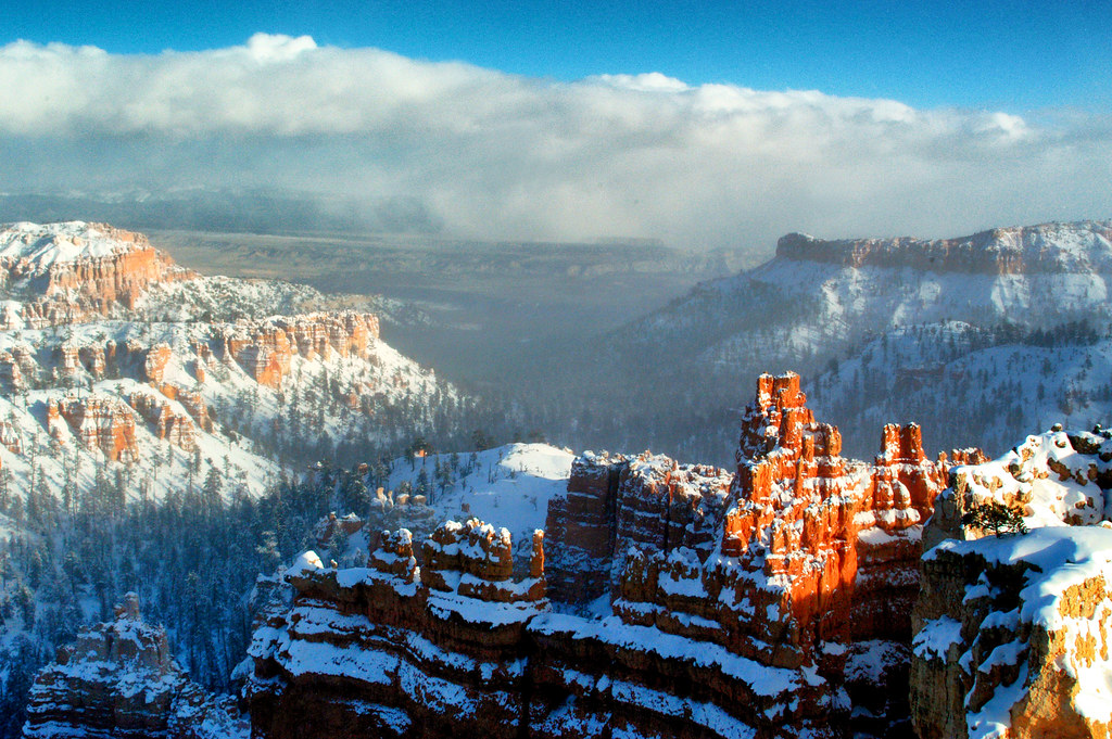
The park’s central geological feature, the amphitheater of hoodoos carved from Claron Formation limestone by freeze-thaw cycles and snowmelt, looks genuinely different under snow, under afternoon thunderstorm light, and in the dry clarity of a May morning. That means there is no universally correct answer, only the right answer for your specific priorities. What follows breaks down each season honestly, so you can weigh the tradeoffs and plan accordingly.
How Elevation Shapes Every Visit to Bryce Canyon
Most visitors arrive expecting a desert and are surprised to find a conifer forest. Bryce Canyon’s rim averages around 8,000 feet at Bryce Point and climbs to 9,105 feet at Rainbow Point, the southern terminus of the 18-mile scenic drive. That elevation differential matters in practical terms: temperatures at the rim run 15 to 20 degrees Fahrenheit cooler than in the towns below. Kanab, Utah, sitting at roughly 4,900 feet about 80 miles south, regularly hits 95 degrees Fahrenheit in July while the rim stays in the low 70s. Afternoon thunderstorms in July and August drop quickly and can include lightning, hail, and dramatic temperature plunges even in midsummer.
The Claron Formation limestone that forms the hoodoos is particularly sensitive to water in its solid and liquid states. The park experiences roughly 200 freeze-thaw cycles per year, more than almost anywhere else on the Colorado Plateau. Water seeps into cracks, freezes, expands, and pries rock apart, which is the primary erosion engine. That same process turns trails into an icy obstacle course between November and April on shaded north-facing slopes, making microspikes a practical necessity for anyone descending into the amphitheater during those months. The park’s geology is inseparable from its weather, which is why understanding seasonal conditions is the foundation of planning any visit here.
The scenic drive itself runs roughly 18 miles one way from the visitor center to Rainbow Point, passing 13 named viewpoints including Sunrise Point, Sunset Point, Inspiration Point, and Bryce Point. Fairyland Point sits about a mile north of the visitor center and is often overlooked by first-timers. Natural Bridge, Agua Canyon, and Ponderosa Canyon offer progressively quieter stops the farther south you drive, since most day visitors cluster around the main amphitheater viewpoints between Sunrise and Bryce Points.
Best Time to Visit Bryce Canyon National Park: What Each Season Actually Offers
Spring (March through May)
Spring arrives unevenly at Bryce Canyon. March on the rim can still deliver feet of snow, and the park’s primary trail system, including the Navajo Loop (1.3 miles, 550 feet of elevation change) and the Queen’s Garden Trail (1.8 miles round trip, 320 feet), may require microspikes well into April on shaded switchbacks. By mid-May, most trails are clear, wildflowers are pushing through the ponderosa pine forest floor, and mule deer are dropping to lower elevations with newborns. Crowds are measurably lighter than summer, and the light quality in May, with frequent partly cloudy skies and low humidity, produces exceptional photography conditions, particularly at the golden hour around Inspiration Point.
May is widely considered the best overall month to visit Bryce Canyon for travelers who want manageable crowds and fully accessible trails. Temperatures at the rim average highs in the mid-50s to low 60s Fahrenheit and lows in the upper 20s to mid-30s, so layering is non-negotiable even in late spring. The park’s free shuttle system, which runs between Ruby’s Inn and Bryce Point with stops at all major viewpoints, typically begins operating in spring, confirm the current start date on the official park site before relying on it for your itinerary.
Summer (June through August)
Summer is the park’s peak season in terms of visitor volume, with July and August bringing the most crowds. Parking at Sunset Point can fill by mid-morning on weekends. The rim trail between Sunrise and Sunset Points (roughly 0.5 miles, minimal elevation change, fully paved) sees constant foot traffic. That said, summer has genuine advantages: all trails are snow-free, the Under-the-Rim Trail (22.9 miles one way) is fully accessible for backpackers, and the combination of monsoon thunderstorms in late afternoon creates some of the most dramatic cloud formations above the amphitheater. Peregrine falcons nest on the canyon walls in early summer, and California condors, reintroduced to the region in the late 1990s, are frequently spotted soaring above the rim.
The heat that makes the desert parks below unbearable actually makes Bryce Canyon more comfortable in June and July than at any other time. Rim temperatures in July average highs around 72 to 78 degrees Fahrenheit, though inside the canyon, exposed south-facing slopes can feel significantly warmer. The critical planning note for summer is arriving early, before 8:30 a.m., or using the shuttle to avoid parking gridlock. The Fairyland Loop (8 miles, 1,700 feet of elevation change) remains far less crowded than the main amphitheater trails even at peak season because its trailhead requires a short drive north of the visitor center.
Fall (September through November)
September represents a sharp transition at Bryce Canyon: crowds thin noticeably after Labor Day weekend, temperatures moderate, and the aspen groves in the park’s higher elevations, particularly near Rainbow Point and Yovimpa Point, shift to gold and amber by late September into October. The bristlecone pines along the Bristlecone Loop Trail (1 mile, 200 feet of elevation change, at 9,000 feet elevation) are at their most photogenic against October’s blue skies.
| Season | Typical Rim High (°F) | Trail Conditions | Crowds | Key Consideration |
|---|---|---|---|---|
| Spring (Mar-May) | 40-62 | Icy through April, clear by mid-May | Low to moderate | Microspikes needed early spring |
| Summer (Jun-Aug) | 72-80 | Fully open, dusty on canyon floors | High (peak Jul-Aug) | Afternoon thunderstorms, arrive early |
| Fall (Sep-Nov) | 35-65 | Clear through Oct, snow possible Nov | Low to moderate | Aspen color peaks late Sep to mid-Oct |
| Winter (Dec-Feb) | 25-40 | Snow-covered, microspikes essential | Very low | Snow-dusted hoodoos, limited services |
October is arguably the most underrated month in the park calendar. The shuttle has typically reduced service or ended for the season (confirm current schedules on the official park site), which means slightly more driving flexibility. Overnight temperatures drop into the 20s, so camping requires a four-season sleeping bag, but daytime conditions for hiking are close to ideal: cool, dry air, low UV index compared to summer, and the kind of side-lit afternoon sun that turns red Claron rock almost orange against a deep blue sky.
Winter (December through February)
Winter at Bryce Canyon is a genuine and distinct experience rather than simply an off-season afterthought. Annual snowfall at the rim averages around 95 inches, and the amphitheater holds snow in protected alcoves and on the faces of the hoodoos themselves for days after a storm. The visual contrast between the terracotta and salmon limestone columns and a fresh white snowpack is the primary reason many photographers specifically target January and February. The park keeps the scenic drive plowed, though Rainbow Point road may close temporarily after heavy snow events. Check road conditions on the official park site before driving south of Inspiration Point in winter.
- Snowshoe rentals are sometimes available at the visitor center in winter; verify current availability on the official park site
- The Rim Trail between Sunrise and Sunset Points is often packed down enough for walking in micro-traction devices
- Navajo Loop and Queen’s Garden descend into the canyon on ice-covered switchbacks and require microspikes at minimum
- Utah State Highway 12, the primary scenic approach from the east through Red Canyon, can be icy and occasionally requires chains; allow extra drive time from Escalante (roughly 43 miles east)
- The park visitor center typically operates on reduced winter hours; confirm on the official park site
- Lodging options near the park shrink substantially in winter, making reservations months in advance advisable
Practical Planning Details: Permits, Fees, and Getting There
Entrance Fees and Passes
Bryce Canyon charges a per-vehicle entrance fee that covers seven consecutive days of access. If you plan to visit multiple national parks on the same trip, the America the Beautiful annual pass covers entrance to all federal lands and pays for itself quickly given the proximity of other major parks. Zion National Park sits roughly 85 miles to the west via Utah State Highway 9, Capitol Reef National Park is about 120 miles to the northeast via Scenic Byway 12, and Grand Canyon‘s North Rim is approximately 170 miles to the south. Confirm current fee amounts on the official park site before budgeting, as they are subject to change.
No advance permit is currently required for day hiking the popular amphitheater trails, which is one meaningful advantage Bryce holds over some neighboring parks where timed entry systems have been implemented. The Fairyland Loop and the Under-the-Rim Trail can be completed permit-free as day hikes, though overnight backpacking anywhere in the backcountry does require a backcountry permit. Campers at North Campground and Sunset Campground should make reservations as far in advance as possible for summer visits, as sites fill weeks out during peak season. Confirm current reservation requirements on the recreation.gov portal before finalizing dates.
Getting to the Park and Orienting on Arrival
Bryce Canyon City, the small community just outside the park entrance, sits at roughly 7,900 feet on Utah State Highway 12 and 63. The nearest commercial airport with regular service is in Las Vegas, Nevada, roughly 270 miles to the southwest, a drive of about four hours under normal conditions via Interstate 15 north and US-89 north. Salt Lake City’s airport is approximately 270 miles to the north, a similar drive via Interstate 15 south and US-89 south, though that route passes through more canyon terrain and can take four and a half to five hours. Cedar City, Utah, roughly 80 miles west, has a small regional airport with limited service and is a practical base for travelers who want a shorter daily drive to the rim.
Once inside the park, orientation is straightforward. The visitor center sits near the north entrance, and the scenic drive runs due south for 18 miles to Rainbow Point. Most first-time visitors allocate a half day for the main amphitheater viewpoints and one of the short canyon descents, but the full scenic drive plus a hike on the Bristlecone Loop at the southern end is a full day’s outing. If you are combining Bryce with a broader Utah itinerary, the nearby Glen Canyon National Recreation Area to the east offers a completely different landscape dominated by water, sandstone, and reservoir recreation. For context on planning a broader southern Utah trip, the spring season coverage of Glen Canyon National Recreation Area is a useful reference.
Gear Checklist by Season
The single most common preparation mistake at Bryce Canyon is arriving with desert hiking gear in a park that does not behave like a desert. The following list addresses the specific conditions each season demands, based on the elevation and weather patterns described above.
- All seasons: Sun protection (SPF 50 minimum, UV exposure is intense above 8,000 feet even in winter), at least two liters of water per person for canyon descents, and trekking poles to manage the steep return climbs out of the amphitheater
- Spring (March to April): Microspikes or crampons for shaded switchbacks, waterproof boots, mid-layer insulation, and rain shell; temperatures can drop 20 degrees in under an hour during afternoon fronts
- Spring (May) and Fall (September to October): Layering system with a fleece or softshell, light gloves for early morning starts, and trail runners or low-cut hiking boots once trails are fully clear
- Summer (June to August): Start hikes by 7:30 a.m. to finish canyon descents before afternoon thunderstorms build; lightweight rain jacket in pack at all times, and electrolyte supplements for longer outings on exposed canyon floors
- Winter (November to February): Microspikes are non-negotiable for any trail below the rim; gaiters to keep snow out of boots on post-holed sections; insulated waterproof boots; balaclava and insulated gloves for wind-exposed rim viewpoints
Best Time to Visit Bryce Canyon: A Quick Comparison for Different Traveler Types
The honest answer is that Bryce Canyon rewards visitors across all twelve months, but the experience varies so dramatically by season that the “best” window is genuinely visitor-specific. A photographer chasing snow-capped hoodoos and empty viewpoints will find January and February almost ideal despite the cold. A family with young children needs fully clear, dry trails and warm midday temperatures, which points squarely to late May or early June before summer crowds peak. A backpacker targeting the Under-the-Rim Trail wants July or August when water sources along the route are most reliable, keeping in mind that all backcountry water requires treatment.
| Traveler Type | Recommended Window | Primary Reason | Key Tradeoff |
|---|---|---|---|
| Photographers | January to February, May | Snow contrast in winter; low-humidity light in May | Cold logistics in winter; short windows for golden-hour shots |
| Families with young children | Late May to mid-June | Clear trails, warm midday temps, moderate crowds | Shuttle still needed; lodging books fast |
| Backpackers | July to August | Fully open Under-the-Rim Trail, reliable water sources | Afternoon lightning risk, hottest canyon floors |
| Crowd-averse hikers | October, February | Fewest visitors, distinct seasonal character | Cold nights, reduced services, winter driving risk |
| Wildlife observers | May to June, September | Fawn season, condor soaring, fall raptor migration | May still transitional; September crowds drop quickly |
| Budget travelers | November, March | Lower lodging rates near park entrance | Trail conditions unpredictable, some services closed |
One consideration that rarely appears in surface-level guides: Bryce Canyon is one of the best certified Dark Sky parks in the United States, and the new moon periods in summer and early fall offer some of the most accessible Milky Way viewing on the Colorado Plateau. The amphitheater’s south-facing bowl acts as a natural amphitheater for the galactic core when it rises in the southeast between May and September. The rim viewpoints near Inspiration Point face the right direction, sit above most artificial light sources, and require no trail descent, making them practical for nighttime visits even for visitors who do not want to hike in the dark.
Putting It All Together: Planning a Visit That Matches Your Priorities
If you are working through your options and want a single reliable recommendation for a first visit, late May through early June consistently delivers the strongest combination of accessible trails, tolerable crowds, and excellent light. Temperatures at the rim stay comfortable for hiking through midday, the free shuttle is running, and the Navajo Loop’s famous Wall Street section, a narrow slot between 100-foot fins of Claron limestone, is fully open and free of ice. That said, book lodging at least three months in advance for any weekend stay in that window, because options within 10 miles of the park entrance are limited and fill early.
For travelers who have already visited once in peak season and want a different perspective, October and January represent the most compelling return visits. October brings aspen color and the quietest hiking of the year on trails that are still fully accessible. January requires preparation and respect for the conditions, but the reward is a completely transformed amphitheater where the hoodoos wear snow caps, the viewpoints hold only a handful of other visitors, and the silence inside the canyon on a calm winter morning is something genuinely difficult to find anywhere else in the American Southwest.
Whatever window you choose, the practical fundamentals remain the same: start early, carry more water than you think you need, never underestimate the elevation’s effect on both temperature and exertion, and build more time into your itinerary than the short trail distances suggest. The Navajo Loop’s 1.3 miles look easy on paper but involve 550 feet of descent followed by 550 feet of return climb at altitude, which takes most visitors significantly longer than expected. Plan conservatively, dress in layers, and the canyon will almost certainly exceed your expectations regardless of which season earns the “best time visit Bryce” title for your specific trip.
Interested in learning more? Explore our Grand Canyon National Park to Implement Additional Water Conservation Measures Beginning April 11 to see how we can help bring your vision to life.