Channel Islands National Park Travel Guide: Ferries, Camping, Hiking, and Wildlife
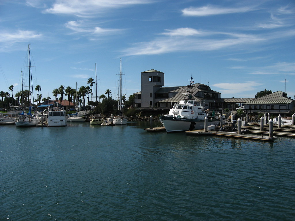
Photo: Ken Lund via Flickr (CC BY-SA 2.0)
At Channel Islands National Park, morning light reaches Scorpion Anchorage while the ferry still rises and drops against the landing pier. Gulls cut across the cliffs, salt spray cools the deck, and the dry scent of coastal sage replaces the mainland harbor air. Once ashore, the road gives way to gravel and then exposed trail, with no vehicles, shops, or quick supply stops waiting beyond the dock.
Five islands form the national park off Southern California: Anacapa, Santa Cruz, Santa Rosa, San Miguel, and Santa Barbara. Reaching them requires advance ferry planning, while camping and hiking demand more self sufficiency than their proximity to Ventura suggests. Our guide begins with island selection, mainland logistics, ferry travel, and the principal routes that fit a first visit.
Understanding Channel Islands National Park Travel
The park protects about half of the eight island Channel Islands chain, plus surrounding marine habitat. The four northern park islands once formed a larger Pleistocene landmass called Santarosae. Rising seas separated them after the last ice age, while tectonic uplift, wave erosion, and recurring landslides continue to shape their cliffs, sea caves, terraces, and narrow beaches.
Five Channel Islands National Park Islands with Different Travel Demands
Santa Cruz receives the greatest number of first time visitors because Scorpion Anchorage combines comparatively frequent boat access with a campground and several independent hiking routes. Anacapa works well for a shorter visit focused on cliff scenery and seabirds. Santa Rosa requires a longer crossing and rewards hikers with broader beaches, grasslands, Torrey pines, and routes extending far beyond the landing area.
San Miguel is colder, windier, and more remote. Access beyond the immediate landing area may involve ranger led travel because of unexploded military ordnance and sensitive resources. Santa Barbara Island lies well south of the other park islands and has steep landing terrain. Boat service, landing access, and closures can affect either remote island, making them less predictable choices for a first trip.
Ecology shaped by isolation
Island foxes live on Santa Cruz, Santa Rosa, and San Miguel. Each island population is recognized as its own subspecies, the result of long isolation. Anacapa instead supports major nesting colonies of western gulls and California brown pelicans. Offshore, seasonal sightings can include gray whales, humpback whales, dolphins, sea lions, and harbor seals, although wildlife encounters vary with migration, weather, and feeding conditions.
Channel Islands National Park Ferries, Trailhead Access, and Mainland Parking
There are no bridges or public vehicle ferries to the park. Most visitors travel aboard concessioner passenger boats from Ventura Harbor, with some routes or excursions using Channel Islands Harbor in Oxnard. The ferry reservation and campground reservation are separate transactions. Campers should secure both before building an itinerary, since a campsite does not guarantee transportation to the island.
Choosing a crossing in this Channel Islands National Park travel guide
Crossing times depend on the destination, sea state, wildlife stops, and vessel. Anacapa and eastern Santa Cruz generally require about an hour from the mainland. Santa Rosa commonly takes roughly three hours, while San Miguel can require four hours or longer. Boats may pitch sharply after leaving the protected harbor, particularly where northwest swell and wind cross the Santa Barbara Channel.
| Destination | Typical crossing | Best suited to | Key limitation |
|---|---|---|---|
| East Anacapa | About 1 hour | Day hiking, seabirds, overlooks | Stairs and exposed terrain |
| Scorpion Anchorage, Santa Cruz | About 1 hour | First visits, camping, varied hikes | Limited shade on trails |
| Santa Rosa | About 3 hours | Backcountry scale, beaches, longer hikes | Wind and long distances |
| San Miguel | About 4 hours or longer | Experienced, prepared visitors | Restricted travel and rough exposure |
Parking, check in, and loading gear
Allow time to park in the designated harbor area, carry equipment to check in, and transfer bags to the crew. Large rigid coolers and excessive loose gear make loading difficult. Fuel canisters, sharp tools, and other camping equipment may have special transport procedures. Ferry schedules, fares, baggage rules, landing status, campground requirements, and parking instructions should be confirmed on the official park site before departure.
- Pack food in sealed containers that resist foxes, ravens, gulls, and mice.
- Keep rain layers, sun protection, medication, and seasickness supplies in a small accessible bag.
- Protect electronics and sleeping gear from spray with dry bags or waterproof liners.
- Carry all required water unless the current destination information explicitly confirms a reliable potable supply.
Hiking from Scorpion Anchorage on Santa Cruz Island
Scorpion Anchorage provides the park’s clearest introduction to island hiking. Trails begin near the landing and campground, eliminating the usual trailhead drive and parking search. The tradeoff is commitment: hikers must return before the boat’s boarding time, and missed transportation can become a serious logistical problem. Cell service is inconsistent, so save maps offline and carry the paper map supplied during orientation.
Cavern Point Loop and Potato Harbor
The Cavern Point Loop covers about 2 miles and climbs rapidly from Scorpion Canyon to the marine terrace. Walking the loop clockwise places the steepest ascent on the climb rather than the descent. The exposed rim overlooks sea caves, kelp beds, and the channel toward Anacapa. Cliff edges can be unstable, and there are no protective barriers along much of the route.
Extending the route along the coastal plateau
Continuing to Potato Harbor produces a hike of roughly 5 miles round trip from Scorpion Anchorage. After the initial climb, the trail rolls across open grassland and coastal scrub before reaching an overlook above a rounded cove. The path provides little shade, and summer heat feels stronger on the pale, dry plateau than temperatures recorded near the water.
Smugglers Cove for a harder day
Smugglers Cove is about 7.5 miles round trip from Scorpion and involves approximately 1,400 feet of cumulative elevation gain. The route follows a broad former ranch road over exposed ridges before descending to a cobble and sand beach. The return begins with a sustained climb, so hikers should reserve water and energy rather than treating the beach as the physical endpoint.
Matching Trails to Time and Ability
Island mileage can be deceptive. Strong wind increases effort, treeless slopes provide limited relief from the sun, and loose gravel complicates descents. Ferry deadlines also remove flexibility. Our team recommends choosing a turnaround time before leaving the landing, then shortening the route if wind, heat, or slower than expected progress consumes that margin.
Representative Hiking Routes in Channel Islands National Park
| Island and route | Approximate distance | Difficulty | Main experience |
|---|---|---|---|
| Anacapa, Inspiration Point area | About 1.5 miles | Easy to moderate | Clifftop views and seabird habitat |
| Santa Cruz, Cavern Point Loop | About 2 miles | Moderate | Sea caves and channel panoramas |
| Santa Cruz, Potato Harbor | About 5 miles | Moderate | Coastal plateau and cove overlook |
| Santa Cruz, Smugglers Cove | About 7.5 miles | Strenuous | Ridge travel and remote beach |
| Santa Rosa, Torrey Pines | About 5 miles | Moderate to strenuous | Rare island pine woodland |
Physical demands beyond mileage
East Anacapa begins with a climb of more than 150 metal stairs from the landing, an immediate consideration for visitors carrying children or bulky equipment. Santa Rosa routes cross open terrain where powerful prevailing winds can slow walking considerably. On every island, hikers should expect uneven surfaces, minimal shade, and limited opportunities to replace water once they leave the landing or campground area.
Walking East Anacapa’s Clifftop Loop
East Anacapa has only about 1.5 miles of maintained trails, but the landing adds a significant physical obstacle. After stepping from the boat, visitors climb more than 150 metal stairs to reach the island’s flat upper surface. Carry water and camera equipment in a backpack so both hands remain available. The return descent can feel steeper, particularly when wind funnels around the landing cove.
From the visitor area to Inspiration Point
The signed loop crosses low coastal vegetation toward Cathedral Cove and Pinniped Point before reaching Inspiration Point at the western end of East Anacapa. From the overlook, Middle and West Anacapa appear as narrow volcanic ridges divided by surge channels. Stay on established paths because burrowing seabirds nest close to the trail, and thin soil near cliff edges can collapse without warning.
Arch Rock and seasonal bird activity
The route returns past viewpoints toward Arch Rock, a natural span rising from the water near the island’s eastern end. Western gull nesting peaks during spring and early summer, when birds occupy much of the plateau and may defend nests beside the path. Pelicans, cormorants, and peregrine falcons also use the cliffs. Expect strong odors, constant calls, and droppings during the nesting period.
Longer Hiking on Santa Rosa Island
Santa Rosa begins at Bechers Bay, where hikers face greater distances and stronger wind than at Scorpion Anchorage. Water Canyon Campground lies about 1.5 miles from the pier, so overnight visitors must carry every bag along the coastal road. Day hikers should account for this approach when calculating mileage and preserve enough time for the walk back to the landing.
The Torrey Pines route
The Torrey Pines hike covers roughly 5 miles round trip and climbs from open grassland into one of only two naturally occurring Torrey pine populations in the world. The island trees form a distinct subspecies from those near San Diego. The steepest climbing comes near the grove, with loose soil and little protection from northwest winds. A longer loop can increase both mileage and elevation substantially.
Inside the grove, dry needles soften the ground while twisted trunks interrupt the wind. The channel appears between branches, far below the terrace edge, and the sound shifts from exposed gusts to a lower rush through the crowns. That brief shelter can mask how quickly conditions change outside the trees, so layers should remain accessible for the descent.
Beaches and backcountry scale
Water Canyon Beach is the practical coastal objective near the campground, while destinations such as East Point and Skunk Point require much longer travel. Santa Rosa backcountry beach camping is limited to designated areas and seasons because surf, tides, wildlife protection, and snowy plover nesting affect access. These routes suit experienced backpackers who can carry water, navigate without dependable service, and alter plans when wind makes progress unsafe.
Channel Islands National Park Camping, Weather, and Trail-Specific Gear
Each park island has a designated campground, but ferry space and camping reservations must be arranged separately. Campsites are generally exposed to wind, and island foxes, ravens, and mice investigate unattended food. Store food and scented items securely, keep tent doors closed, and never feed wildlife. Budget separately for passenger transportation and the campground reservation fee when planning a Channel Islands National Park overnight trip.
Conditions through the year
| Period | Typical trail conditions | Planning priority |
|---|---|---|
| March through May | Green slopes, wildflowers, cool wind, possible rain | Pack rain protection and avoid muddy trail edges |
| June through September | Dry exposed ground, stronger sun, limited shade | Carry extra water and start longer hikes promptly |
| October through November | Clearer days mixed with wind events | Use secure tent stakes and flexible route choices |
| December through February | Cool temperatures, storms, rougher crossings | Protect insulation from spray and allow weather flexibility |
What belongs in the pack
- Water capacity: Carry enough for the full hike, cooking, and an emergency delay.
- Wind protection: Bring a close fitting shell rather than relying on a light poncho.
- Traction: Wear shoes with reliable tread for gravel, steep ranch roads, and damp boat landings.
- Navigation: Download maps before boarding and carry a paper backup.
- Sun defense: Use a secure hat, sunglasses, sunscreen, and long sleeves on treeless plateaus.
- Camp security: Pack robust food storage and stakes suited to hard, wind exposed ground.
Building a Reliable Island Itinerary
First time visitors gain the most flexibility from Scorpion Anchorage, where Cavern Point, Potato Harbor, and Smugglers Cove provide clear choices for different abilities. Anacapa fits a shorter outing centered on overlooks and bird life. Santa Rosa deserves an overnight stay or a carefully paced long day because the campground approach, wind, and wider spacing between landmarks consume time quickly.
Choose the island first, then reserve transportation and camping before selecting the final trail. Match mileage to the ferry deadline, expected exposure, and the slowest person in the group. With water, wind layers, secure food storage, and a firm turnaround time, Channel Islands National Park becomes manageable without losing the remote character that defines its cliffs, grasslands, beaches, and endemic wildlife.
Want to keep exploring? Browse all our Channel Islands guides and articles for more trip-planning tips and ideas.
Gear & Essentials
Tell us about your trip and we will add what else you will want:
The basics
Worth having in the car whatever the park.
For this trip
Traveling with kids
Bringing a pet
RVing
Backcountry
Winter conditions
On the water
Photography
Accessibility
As an Amazon Associate we earn from qualifying purchases, at no extra cost to you.