Joshua Tree National Park in Fall: What to Expect and What to Do
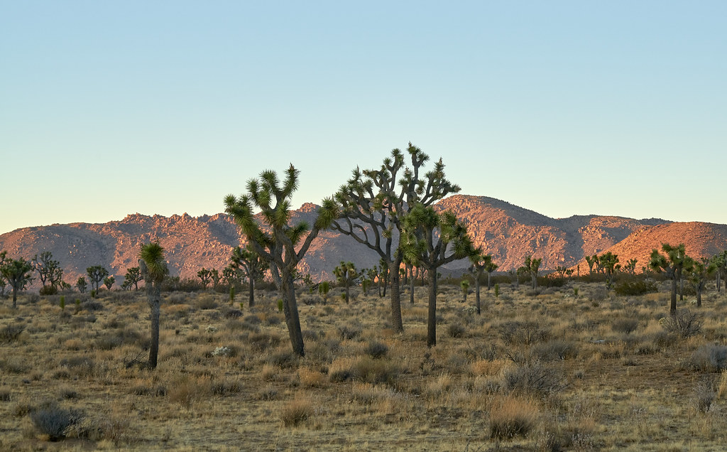
Photo: szeke via Flickr (CC BY-SA 2.0)
At sunrise in Joshua Tree National Park, the granite walls of Hidden Valley warm from gray to amber while cool air settles among pinyon pines, junipers, and branching Joshua trees. Sand crunches underfoot, ravens call above the rocks, and the temperature can feel surprisingly cold before direct sunlight reaches the valley floor. By afternoon, those same boulders radiate heat and the exposed trail feels several degrees warmer.
Fall brings that daily temperature swing into sharp focus. September often retains summer heat, October marks the main transition, and November delivers cooler hiking weather with longer nights. Our guide explains how conditions change through the season, where crowds alter a day’s plans, which roads and trails make sense, and how fall compares with other times of year.
What to Expect in Joshua Tree National Park in Fall
Joshua Tree National Park covers nearly 800,000 acres where the higher Mojave Desert meets the lower Colorado Desert. Elevation ranges from roughly 500 feet near the southeastern boundary to 5,814 feet on Quail Mountain. Because temperature falls with elevation, conditions at Keys View, Hidden Valley, and the Pinto Basin can differ substantially on the same afternoon.
September, October, and November Are Distinct
September should be treated as an extension of summer, especially around Cottonwood Spring, Cholla Cactus Garden, and the lower Pinto Basin. Afternoon temperatures can remain dangerously hot, so longer hikes belong near sunrise. Cooler conditions usually become more dependable in October, though heat waves still occur. November commonly brings comfortable afternoons, cold evenings, and occasional freezing temperatures at higher campgrounds.
Rain is infrequent but consequential. A distant storm can send water across washes and low road crossings, while short downpours make normally dry channels hazardous. Autumn winds also matter. Exposed campsites can become dusty, and strong gusts make climbing, cooking, and tent setup difficult even when the temperature appears ideal.
Two Deserts Shape the Experience
The Mojave section occupies much of the western and central park, generally above 3,000 feet. This is the Joshua tree landscape seen around Hidden Valley, Ryan Campground, Cap Rock, and Queen Valley. Joshua trees are yuccas adapted to colder desert elevations, and their distribution thins as the road descends east toward the Pinto Basin.
The Colorado Desert dominates the lower east and south. Creosote bush, ocotillo, smoke tree, and cholla replace the Joshua tree woodland. Cholla Cactus Garden sits in this transition at about 1,700 feet, while Cottonwood lies around 3,000 feet near the southern entrance. In early fall, these areas demand more water and earlier starts than trails in the western highlands.
How Fall Compares With the Rest of the Year
Fall balances trail access, manageable temperatures, and increasingly busy weekends. Roads and major trailheads generally remain open throughout the year, but summer heat limits safe hiking and winter storms can briefly affect higher roads. Spring has mild weather and possible wildflowers, yet it also produces some of the park’s heaviest visitation.
Season by Season Decision Table
| Season | Typical conditions | Crowd pattern | Best suited to | Access considerations |
|---|---|---|---|---|
| Fall | Hot in September, increasingly mild by October, cold nights by November | Moderate early, busy on October and November weekends | Hiking, climbing, camping, photography, stargazing | Heat remains a concern at low elevations |
| Winter | Cool days, freezing nights, occasional snow at higher elevations | Busy during holidays and mild weekends | Long hikes, climbing, clear distance views | Wind, ice, or snow can temporarily affect roads and trails |
| Spring | Mild to warm days, cool nights, variable wind | Often the busiest period | Wildflowers, hiking, camping, climbing | Parking fills early at popular trailheads |
| Summer | Extreme daytime heat with warm nights at lower elevations | Lower overall visitation | Short sunrise stops and night sky viewing | Long hikes and exposed daytime activity become hazardous |
Choosing the Best Time to Visit Joshua Tree National Park in Fall
September works best for travelers focused on sunrise photography, scenic driving, and short walks. October supports a broader mix of hiking and climbing, particularly in the western park. November is our team’s strongest choice for strenuous routes, though short daylight hours require an early start and overnight temperatures can drop sharply.
- Choose September for fewer visitors, warm nights, and brief dawn outings.
- Choose October for balanced temperatures and a full range of activities.
- Choose November for longer hikes, cooler rock, and crisp night skies.
- Avoid holiday weekends if easy parking and quiet campsites matter most.
Planning for Fall Access and Crowds in Joshua Tree National Park
Three paved entrance roads serve the park. The West Entrance near Joshua Tree provides the most direct approach to Hidden Valley and Keys View, while the North Entrance near Twentynine Palms often provides a practical alternative. The South Entrance connects with Interstate 10 and approaches through the Colorado Desert near Cottonwood.
Driving Times and the Park’s Scale
Visitors frequently underestimate the distance between major sights. Driving from the West Entrance area to Cottonwood typically takes about 90 minutes without stops. Hidden Valley to Cholla Cactus Garden requires roughly 45 minutes, and detours to Keys View add time on a dead end road. Fuel is unavailable inside the park, so fill the tank before entering.
Pinto Basin Road links the higher Mojave scenery with the lower Colorado Desert. The descent reveals changing vegetation, broad alluvial fans, and dark mountain ranges formed by faulting and erosion. Cell service is unreliable, making an offline map or paper park map more useful than turn by turn navigation.
What Crowds Change in Practice
Fall congestion concentrates between late morning and mid afternoon at Hidden Valley, Barker Dam, Keys View, and roadside climbing areas. A full parking lot can force visitors to revise an itinerary because roadside parking damages vegetation and may obstruct traffic. Entering before 8 a.m. or beginning on the quieter eastern side usually produces a smoother day.
Reservations, Camping, and Permits
Advance reservations are commonly used at several campgrounds during the busy fall season, while other camping options may follow different systems. Entrance reservations are not generally required, but backcountry travelers must follow current registration rules. Fees, reservation windows, campground status, and temporary closures can change, so confirm current details on the official park site before booking.
A Practical First Day Route
For a first visit, enter from the west or north early and begin with the one mile Hidden Valley loop. Continue to the 1.1 mile Barker Dam loop, where rock formations and cultural sites provide more interest than the seasonal reservoir alone. Drive to Keys View at 5,185 feet for a broad look across the Coachella Valley and San Andreas Fault.
After midday, follow Park Boulevard through Queen Valley and descend Pinto Basin Road. The quarter mile Cholla Cactus Garden loop is short but exposed, with dense teddy bear cholla whose barbed segments detach easily. Finish near Cottonwood rather than retracing the entire park, provided your lodging and onward route make the South Entrance practical.
Match Fall Trails to Temperature and Daylight
Trail choice should follow elevation, exposure, and the month of travel. September favors short routes among the granite formations, while November makes sustained climbs and open desert crossings more reasonable. Sunset arrives progressively earlier through fall, and twilight fades quickly behind the Little San Bernardino Mountains. Carry a headlamp even when the planned return falls before dusk.
Short Walks With High Scenic Value
Cap Rock Nature Trail covers about 0.4 mile through Joshua tree woodland, making it useful when heat or limited time rules out a longer hike. Arch Rock can be reached on a roughly 1.4 mile round trip from the Twin Tanks area. Farther east, the 1.3 mile Discovery Trail links Skull Rock with broad washes and monzogranite formations while avoiding some roadside congestion.
Longer Routes for Cool November Days
Ryan Mountain rises to 5,457 feet on a three mile round trip with about 1,050 feet of climbing. The exposed ascent rewards an early start with views over Queen Valley, Lost Horse Valley, and the Wonderland of Rocks. Lost Horse Mine Loop covers approximately 6.5 miles through open terrain and passes a historic ten stamp mill associated with mining activity from the late 1800s.
| Trail | Approximate distance | Terrain | Best fall window |
|---|---|---|---|
| Cap Rock | 0.4 mile | Mostly level desert path | September through November |
| Arch Rock | 1.4 miles | Sandy washes and granite | October and November |
| Ryan Mountain | 3 miles | Steep, exposed climb | Late October and November |
| Lost Horse Mine Loop | 6.5 miles | Rolling, exposed backcountry | November |
Road Conditions Can Reshape the Day
The paved park roads support ordinary passenger vehicles, but several side routes enter rougher country. Heavy rain can leave sand, ruts, and debris long after a storm has passed. Drivers should never enter a flooded wash or assume that tire tracks indicate safe passage. Standard rental agreements may also restrict travel on unpaved roads, regardless of vehicle capability.
When to Keep the Itinerary on Pavement
Park Boulevard, Pinto Basin Road, Keys View Road, and Cottonwood Springs Road connect the principal developed corridors. They provide access to contrasting elevations without requiring specialized equipment. Following a cold storm, shaded sections near Keys View can remain icy after lower roads have dried. In September, the larger concern is vehicle failure in exposed low desert where roadside shade is scarce.
Unpaved Roads Require a Separate Plan
Geology Tour Road forms an 18 mile route through Pleasant Valley, with rough sections where high clearance and four wheel drive may be appropriate. Berdoo Canyon Road is considerably more demanding and should be reserved for properly equipped vehicles and experienced drivers. Before entering either route, check tires, carry extra water, download navigation data, and tell someone where the vehicle is going.
Build a Fall Plan Around Your Main Priority
A successful Joshua Tree National Park visit usually begins with one primary goal. Trying to combine a summit hike, several nature trails, sunset at Keys View, and night photography in one day creates unnecessary driving and missed light. Group stops geographically, then leave room for a full trailhead or slower traffic near the western entrances.
Use This Decision Framework
- For hiking: choose November, start with Ryan Mountain or Lost Horse Mine, and carry at least one gallon of water per person for a full day.
- For climbing: favor cool October or November mornings, inspect anchors and protection, and use established access paths around Hidden Valley and Quail Springs.
- For photography: work among the western Joshua tree woodlands near sunrise, then use the Pinto Basin for wider afternoon landscapes.
- For stargazing: select a moon phase deliberately, bring red lighting, and move away from headlights and busy parking areas.
Plan Overnight Stops by Geography
Camping near Hidden Valley, Ryan, or Jumbo Rocks reduces morning driving for western trails and climbing areas. Cottonwood is better positioned for the southern entrance, Mastodon Peak, and an early departure toward Interstate 10. Black Rock sits apart from the main through road near Yucca Valley, but it provides access to higher elevation trails such as the Panorama Loop and routes toward Warren Peak.
What to Do in Joshua Tree National Park in Fall
October is the most flexible choice for mixed activities, while November better supports exposed climbs and longer backcountry routes. September can still work well when the schedule centers on dawn, scenic driving, and short walks. In every month, elevation changes matter. Conditions at Keys View may be cold and windy while the Pinto Basin remains hot enough to limit hiking.
Choose one part of the park for each half day, match trail length to available daylight, and reserve unpaved roads for a properly equipped vehicle. That approach leaves time to notice the transition from Mojave woodland to Colorado Desert rather than spending the visit racing between landmarks. With water, layered clothing, offline navigation, and an early start, fall provides the broadest practical range of experiences in Joshua Tree National Park.
Want to keep exploring? Browse all our Joshua Tree guides and articles for more trip-planning tips and ideas.
Gear & Essentials
Tell us about your trip and we will add what else you will want:
The basics
Worth having in the car whatever the park.
For this trip
Traveling with kids
Bringing a pet
RVing
Backcountry
Winter conditions
On the water
Photography
Accessibility
As an Amazon Associate we earn from qualifying purchases, at no extra cost to you.