7 Best Fall Hikes in Joshua Tree National Park
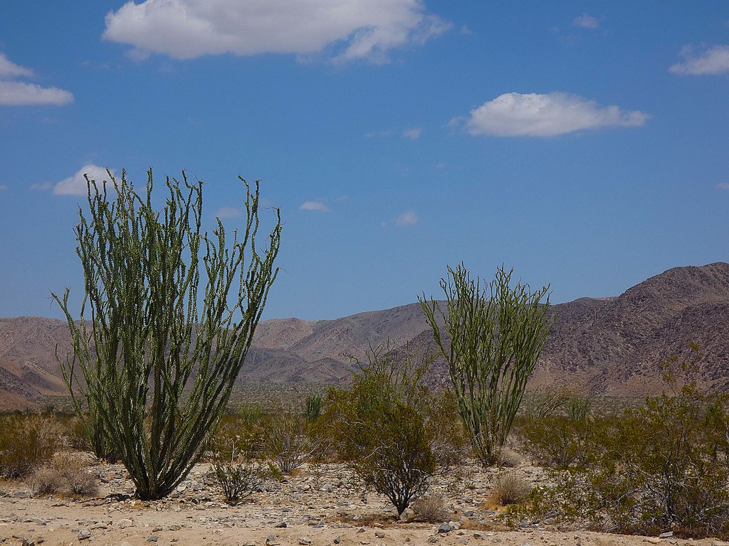
Photo: concrete&fells via Flickr (CC BY 2.0)
The Best Fall Hikes Joshua Tree visitors can tackle combine cooler temperatures, open desert views, and routes ranging from one mile to roughly four miles. Late October through November usually provides the most dependable hiking conditions, while September often retains dangerous summer heat. For a balanced first visit, pair a granite landscape walk such as Hidden Valley with a higher effort route such as Ryan Mountain.
Joshua Tree National Park spans two deserts. The higher Mojave Desert in the west supports Joshua trees, pinyon pine, juniper, and extensive monzogranite formations. The lower Colorado Desert in the east contains ocotillo, cholla, palo verde, and broad alluvial basins. Elevation changes substantially across the park, so temperature and vegetation can differ between trailheads on the same day.
Why fall works so well for Joshua Tree hiking
Autumn reduces the park’s central hiking hazard: prolonged exposure to extreme heat. Afternoon temperatures can remain severe in September, particularly around Cottonwood Spring and other lower elevation locations. Conditions usually moderate during October, then November brings cooler mornings and shorter daylight. Rain remains limited, but isolated storms can flood washes and make normally dry channels unsafe.
October brings improving conditions and rising demand
Early October can still feel like summer. Long, exposed routes require conservative turnaround times, particularly when temperatures climb faster than forecast. By late October, daytime hiking becomes more comfortable at higher trailheads such as Ryan Mountain, Keys View, Hidden Valley, and Black Rock. This transition also draws larger weekend crowds, filling compact parking areas during the late morning.
November favors longer and steeper routes
November usually offers the best balance of cool air and usable daylight. Ryan Mountain and Lost Horse Mine become more manageable because hikers spend less time absorbing heat on exposed slopes. Cold fronts can produce strong winds and near freezing temperatures at higher elevations, however. A sunny forecast at a nearby desert town does not account for wind chill on an open ridge.
Fall conditions vary between the Mojave and Colorado deserts
The western Mojave portion generally sits higher and contains most of the park’s famous Joshua tree woodlands and granite formations. The eastern Colorado Desert is lower, warmer, and more sparsely shaded. Mastodon Peak can therefore feel considerably hotter than Hidden Valley on the same afternoon. Our team recommends placing lower elevation hikes early in the day and saving short western walks for later.
7 Best Fall Hikes in Joshua Tree National Park at a Glance
These seven routes cover the park’s major landscapes without requiring technical climbing or overnight travel. Distances vary slightly where informal paths branch from the main trail, so follow signed junctions and use a current map. Most surfaces involve loose sand, rough granite, or uneven wash crossings rather than smooth constructed tread.
Compare the 7 Best Fall Hikes in Joshua Tree National Park
| Hike | Distance | Typical difficulty | Primary feature |
|---|---|---|---|
| Hidden Valley | 1 mile loop | Easy | Enclosed granite valley and Joshua trees |
| Barker Dam | About 1.1 miles loop | Easy | Historic water impoundment and rock formations |
| Wall Street Mill | About 2.4 miles round trip | Easy to moderate | Mining ruins and desert history |
| Split Rock | 2.5 miles loop | Moderate | Large monzogranite formations |
| Ryan Mountain | 3 miles round trip | Strenuous | Summit panorama at 5,457 feet |
| Lost Horse Mine | About 4 miles round trip | Moderate | Historic ten stamp mill |
| Mastodon Peak | About 2.4 miles loop | Moderate | Colorado Desert views and mining remains |
Best Fall Hikes Joshua Tree Beginners Should Prioritize
Hidden Valley and Barker Dam give first time visitors the strongest introduction with modest mileage. Hidden Valley passes through a natural opening in granite walls into terrain historically associated with cattle ranching. Barker Dam combines Joshua tree woodland, open rock country, and a small historic reservoir whose visible water level depends on recent precipitation.
Inside Hidden Valley, coarse sand shifts beneath your shoes while rounded monzogranite walls block much of the surrounding desert. Voices and footsteps echo between the formations, then the trail turns and reveals Joshua trees spaced across a pale basin. Shade remains intermittent, but the enclosed terrain can feel cooler than exposed roads and ridgelines when autumn wind moves through the gap.
Routes for elevation, geology, and history
Ryan Mountain provides the broadest summit view, with roughly 1,000 feet of climbing on an exposed stone trail. Split Rock is the better choice for close views of jointed granite, weathered alcoves, and enormous boulders. Wall Street Mill and Lost Horse Mine explain how ranchers and miners used this dry landscape, although unstable structures and abandoned shafts require distance and caution.
How fall compares with the rest of the year
Fall provides a useful middle ground between summer heat and winter weather. It also marks the return of the park’s busiest recreational season. The practical effect is concentrated congestion around popular trailheads, roadside climbing areas, Keys View, and the west entrance corridor. Starting shortly after sunrise can eliminate much of the parking pressure while providing cooler climbing on exposed trails.
Seasonal conditions, access, and crowd patterns
| Season | Typical hiking conditions | Crowd pattern | Access considerations | Best suited to |
|---|---|---|---|---|
| Fall | Hot in September, increasingly mild through October and November | Busy weekends, especially by late fall | Main roads generally accessible, with temporary storm impacts possible | Day hikes, climbing, geology, historic sites |
| Winter | Cool days, freezing nights, occasional snow at higher elevations | Heavy around holidays and mild weekends | Ice or snow can briefly affect elevated roads and trails | Long exposed routes and photography |
| Spring | Mild early, increasingly hot later | Often the busiest period | Parking fills early near major trails | Wildflowers, hiking, and camping |
| Summer | Extreme daytime heat and warm nights | Lower visitation, but greater medical risk | Flash flooding can follow monsoon storms | Short walks near sunrise only |
What crowds change on the trail
Crowds affect more than atmosphere. A full trailhead can force additional roadside walking or a change of plans, while queues form at narrow passages and popular photo locations. Ryan Mountain’s exposed path also offers little room to spread out near the summit. Keep two substitute hikes in the same part of the park so a full parking area does not trigger a lengthy cross park drive.
Plan Access to the 7 Best Fall Hikes in Joshua Tree National Park
The park has paved routes connecting its principal entrances and major trailheads, but distances are larger than the map suggests. Driving between the western Joshua tree country and Cottonwood in the south commonly takes more than an hour without stops. Fuel, food, and substantial water supplies are found outside the park, so arrive prepared rather than relying on services between hikes.
Fees, permits, camping, and reservations
Ordinary day hiking on these routes generally does not require a separate trail permit, although park entrance fees apply. Campground reservation rules, entrance fees, closures, and backcountry registration procedures can change, so confirm current details on the official park site. Autumn campsites can fill well ahead of popular weekends, making early planning important for hikers who want sunrise access.
What to carry on an autumn day hike
- Water: Carry enough for the full route and the return drive. Natural water sources are unreliable and should not be used.
- Sun protection: Bring a brimmed hat, sunglasses, sunscreen, and clothing that covers exposed skin.
- Warm layer: Pack insulation for windy summits and rapid temperature drops after sunset.
- Navigation: Download an offline map and carry a paper backup because mobile coverage is inconsistent.
- Footwear: Use shoes with traction for loose gravel, granite steps, and sandy washes.
- Light: Carry a headlamp even on short afternoon hikes because autumn daylight ends quickly behind the surrounding ridges.
Match the route to the month and temperature
Elevation should guide the day’s trail choice. Ryan Mountain begins near 4,300 feet, while Mastodon Peak starts in the much lower Cottonwood area. That difference can produce noticeably warmer conditions in the south. Check an hourly forecast for the relevant part of the park, then compare the expected temperature with the route’s shade, exposure, and climbing effort.
Use September and early October selectively
During the hotter part of fall, Hidden Valley, Barker Dam, and Wall Street Mill provide convenient turnaround options if temperatures rise quickly. Begin at sunrise and avoid committing to Ryan Mountain after the exposed slope is already heating. Mastodon Peak demands particular caution because its sandy approaches, lower elevation, and reflective rock surfaces increase heat exposure even though the mileage appears modest.
Shift toward strenuous routes in late fall
Late October and November are better suited to Ryan Mountain and Lost Horse Mine. Lost Horse gains elevation gradually before reaching the fenced mill complex, while Ryan Mountain concentrates its climbing into a shorter distance. Strong wind can reverse the apparent advantage of a cool forecast, especially on Ryan Mountain’s summit ridge. Carry gloves and a wind-resistant layer when morning temperatures approach freezing.
| Priority | Best route | Most suitable fall period |
|---|---|---|
| Short first hike | Hidden Valley | October through November |
| Mining history | Wall Street Mill or Lost Horse Mine | Late October through November |
| Summit view | Ryan Mountain | Cool, low-wind days |
| Colorado Desert ecology | Mastodon Peak | Cool November mornings |
| Granite formations | Split Rock | Any mild fall day |
Combine trails without wasting daylight
The Best Fall Hikes Joshua itinerary works better when routes are grouped geographically. Hidden Valley, Barker Dam, Wall Street Mill, Split Rock, Ryan Mountain, and Lost Horse Mine occupy the western or central portion of the park. Mastodon Peak lies far to the south near Cottonwood Spring. Treating it as an add-on between western hikes creates unnecessary driving and reduces the daylight available on foot.
Build a western park hiking day
Start with Ryan Mountain while the slope is cool, then recover over lunch before choosing Hidden Valley or Barker Dam. Wall Street Mill pairs naturally with Barker Dam because both use the same general road corridor. Split Rock works as a substitute when parking around Hidden Valley and Barker Dam is congested, although its loop requires closer navigation around boulders and sandy junctions.
Give Mastodon Peak its own southern plan
Approach Mastodon Peak from Cottonwood Spring and allow time for the loop’s mine remains, wash walking, and short rock scramble near the summit. The route passes through Colorado Desert vegetation that differs sharply from the Joshua tree woodland farther north. Combine it with roadside geology and plant observation rather than attempting a rushed drive back to several western trailheads.
- Choose one strenuous or moderate anchor hike for the morning.
- Select one nearby short loop as the afternoon option.
- Record a substitute trailhead before entering areas with weak mobile reception.
- Set a turnaround time based on sunset, temperature, and remaining driving distance.
Respond to closures, storms, and full parking areas
Joshua Tree’s main paved roads usually remain usable through fall, but localized conditions can change rapidly. Heavy rain sends water and debris across dips, washes, and low road sections. Never drive through moving water or cross a flowing wash on foot. Granite surfaces also become slick after rain, making the final rocks on Mastodon Peak and worn steps on Ryan Mountain less secure.
Know which trailheads require flexible access
Lost Horse Mine involves travel on an unpaved access road that can become rough after storms. Low-clearance vehicles may need a different plan if ruts or washouts develop. Parking around Barker Dam, Hidden Valley, and Ryan Mountain can fill early on autumn weekends. Continue to a planned alternative rather than parking on vegetation or blocking the narrow road shoulder.
Shorten the day without losing its focus
If heat, wind, or congestion rules out the original route, substitute by feature. Choose Hidden Valley for granite and Joshua trees, Wall Street Mill for mining history, or Split Rock for a longer boulder-focused loop. A weather-driven change is especially important at Mastodon Peak because its lower desert setting can remain hot after western trailheads have become comfortable.
Choose from the Best Fall Hikes Joshua Tree Offers
Late October and November provide the broadest range of choices, but route selection still depends on elevation, wind, and trailhead location. Ryan Mountain suits hikers seeking sustained climbing and a high panorama. Hidden Valley and Barker Dam work well for shorter outings, while Lost Horse Mine and Wall Street Mill add physical evidence of the park’s mining and ranching history.
Plan one primary hike and one nearby alternative, carry all required water, and begin exposed routes early. Keep Mastodon Peak for a dedicated southern visit and group the western trails to preserve daylight. With those decisions made before arrival, fall conditions become easier to manage and a crowded trailhead no longer determines the entire day.
Want to keep exploring? Browse all our Joshua Tree guides and articles for more trip-planning tips and ideas.
Gear & Essentials
Tell us about your trip and we will add what else you will want:
The basics
Worth having in the car whatever the park.
For this trip
Traveling with kids
Bringing a pet
RVing
Backcountry
Winter conditions
On the water
Photography
Accessibility
As an Amazon Associate we earn from qualifying purchases, at no extra cost to you.