Joshua Tree National Park: The Perfect 3-Day Itinerary
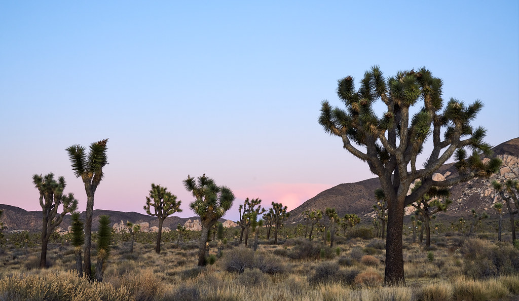
Photo: szeke via Flickr (CC BY-SA 2.0)
Joshua Tree National Park protects the meeting point of two deserts, with Joshua tree woodlands in the higher Mojave Desert and creosote flats descending into the warmer Colorado Desert. Across three days, this route links granite formations, historic water sources, panoramic viewpoints, and the transition between those ecosystems without repeatedly retracing the same park roads.
Our itinerary begins among the best known landscapes near the West Entrance, works east through the boulder country, and finishes near Cottonwood and Interstate 10. It assumes two nights near the park’s northern boundary, where the communities of Joshua Tree, Twentynine Palms, and Yucca Valley provide the broadest choice of lodging, meals, groceries, and fuel.
How the perfect 3-day Joshua Tree National Park route fits together
Joshua Tree covers nearly 800,000 acres, and its main attractions are spread along roughly 60 miles of paved park roads. The landscape also changes considerably with elevation. Quail Mountain reaches 5,814 feet in the Mojave section, while the southeastern boundary drops below 1,000 feet. Temperatures can therefore differ noticeably between Keys View, the central granite basins, and Cottonwood on the same day.
The three-day route at a glance
Day one concentrates on the western highlands, including Hidden Valley, Barker Dam, and Keys View. Day two follows Park Boulevard through the central rock formations before continuing toward Pinto Basin. Day three descends through the Colorado Desert to Cottonwood, creating a practical southbound exit toward Interstate 10. Travelers returning west can reverse the final drive, though that adds substantial backtracking.
| Day | Main stops | Primary highlight | Approximate driving |
|---|---|---|---|
| 1 | West Entrance, Hidden Valley, Barker Dam, Keys View | Joshua tree woodland and high desert sunset | About 1 hour 20 minutes between major stops |
| 2 | Ryan Mountain, Skull Rock, Split Rock, Arch Rock, Cholla Cactus Garden | Granite formations and the Mojave to Colorado Desert transition | About 1 hour 30 minutes between major stops |
| 3 | Pinto Basin, Cottonwood Spring, Mastodon Peak | Fan palm oasis and lower desert geology | About 1 hour 15 minutes from Pinto Basin to the south entrance |
Why the order matters
The western side contains the park’s highest concentration of Joshua trees and short trails, so it rewards an early start before parking areas become busy. The second day allows enough time for Ryan Mountain’s 3-mile round trip and several shorter walks. Saving Cottonwood for the final morning avoids a long return drive north and places the lowest, hottest terrain early in the day.
Prepare for your 3-day Joshua Tree National Park itinerary
There are no fuel stations inside the park, and food options are extremely limited once you pass an entrance station. Fill the tank and buy meals, snacks, and water in one of the northern gateway communities. Mobile reception is unreliable across much of Park Boulevard, Pinto Basin Road, and the backcountry, so download an offline map before arrival.
Water, fuel, and desert supplies
Our team recommends carrying at least one gallon of water per person per day during warm weather, with additional water reserved in the vehicle. The dry air can mask perspiration, particularly during breezy winter and spring hikes. Pack salty snacks, sun protection, a wide brimmed hat, a headlamp, and layers for temperature changes after sunset.
- Begin each morning with a full fuel tank.
- Carry paper directions or an offline navigation app.
- Bring all meals needed between breakfast and dinner.
- Keep water inside the passenger compartment when freezing nights are possible.
- Carry a basic tire kit and avoid unpaved roads in a low-clearance rental vehicle.
Entrance logistics and overnight bases
The West Entrance is convenient from Joshua Tree village but often receives the heaviest traffic. The North Entrance near Twentynine Palms can be faster during busy periods, although using it changes the order of the first day. Entrance fees, campground availability, road closures, and permit rules can change, so confirm current details on the official park site before departure.
For this route, spend both nights along the northern edge of the park. Joshua Tree village gives the quickest access to the West Entrance, while Twentynine Palms sits closer to the North Entrance and the eastern formations. Yucca Valley has more extensive grocery and lodging choices but adds driving each morning. Park campgrounds provide closer access to sunrise locations, though sites can fill well ahead of pleasant spring and autumn weekends.
Choosing the right season
Late October through April usually provides the most comfortable hiking temperatures. Winter days can be crisp and clear, but nights at higher campgrounds frequently approach freezing. Spring brings blooming annuals in favorable rainfall years and flowering cacti at lower elevations. From May into September, afternoon heat can make exposed trails hazardous, especially around Cottonwood and Pinto Basin. Summer visitors should move the longest hike to sunrise and avoid relying on shade, which is scarce throughout the park.
Joshua Tree National Park day one: Joshua trees, ranching history, and Keys View
Enter through the West Entrance shortly after sunrise and follow Park Boulevard into the Mojave Desert uplands. Joshua trees become denser as the road climbs toward Hidden Valley. These plants are branching yuccas rather than trees, and their distribution reflects elevation, winter cold, and moisture. The surrounding monzogranite formed underground and was later exposed as overlying rock eroded away, leaving the rounded stacks seen throughout the western park.
Walk the Hidden Valley Nature Trail
The 1-mile Hidden Valley loop is the best opening walk because it introduces the park’s geology and plant communities without consuming the morning. The trail enters a rock-enclosed basin once associated with cattle grazing. Interpretive signs identify pinyon pine, juniper, yucca, and desert shrubs that survive in pockets where granite walls collect runoff and provide shelter from wind.
Inside the basin, coarse granite grains shift underfoot while blocky walls rise close on both sides. Morning air can remain cold in the shadows even after sunlight reaches the upper rocks. Voices carry between the formations, and climbers may be visible on the faces overhead. Near the far side of the loop, the enclosure briefly opens, revealing Joshua tree crowns against bare stone and giving a clearer sense of the basin’s scale.
Continue to Barker Dam
Drive about 10 minutes to the Barker Dam trailhead and follow the 1.1-mile loop through boulder corridors and open Joshua tree flats. Ranchers constructed the small dam around the turn of the 20th century and later expanded it to hold water for livestock. Water levels vary sharply with rainfall, so visitors may encounter a reflective pool, damp sediment, or a completely dry basin.
Look for cultural evidence along the loop
Beyond the dam, the route passes rock art and traces of the area’s ranching period. Some markings have been altered in modern times, so avoid touching or attempting to enhance faint designs for photographs. Desert bighorn sheep, coyotes, jackrabbits, and numerous birds use this drainage, particularly when water remains in the reservoir. Observe wildlife from a distance and never block its approach to water.
Finish the afternoon at Keys View
Return to Keys View Road and climb to the overlook at approximately 5,185 feet. On clear days, the view extends across the Coachella Valley to the Salton Sea, with the Santa Rosa Mountains and 10,834-foot San Jacinto Peak dominating the skyline. The San Andreas Fault traces a visible line across the valley floor. Arrive well before sunset because the small parking area can fill, then allow roughly 45 minutes to return to the main road after the light fades.
Joshua Tree National Park day two: Ryan Mountain and central rock formations
Begin at Ryan Mountain before direct sun reaches the exposed switchbacks. The 3-mile round trip gains roughly 1,050 feet to a 5,457-foot summit, making it the most demanding walk in this itinerary. The summit overlooks Queen Valley, Lost Horse Valley, and the Little San Bernardino Mountains. Allow two to three hours, including time for the descent, and carry a wind layer because the upper ridge is considerably more exposed than the trailhead.
Choose the essential short walks
After Ryan Mountain, continue east on Park Boulevard to Skull Rock. Weathering along natural fractures produced the formation’s eye sockets, while erosion rounded the surrounding monzogranite into domes and boulder piles. The rock stands beside the road, but the 1.7-mile Skull Rock Nature Trail provides a better look at nearby washes, desert vegetation, and smaller formations overlooked by roadside visitors.
Add Split Rock if time allows
The 2.5-mile Split Rock Loop is a useful optional detour for hikers who still have energy after Ryan Mountain. Its broad granite corridors tend to feel less congested than roadside formations. Otherwise, continue to Arch Rock, reached by an approximately 1.4-mile round trip from the Twin Tanks area. Afternoon light emphasizes the arch’s grain and curved underside, but trail junctions among the rocks can be confusing. Track the return route on an offline map.
Watch the desert change at Cholla Cactus Garden
Follow Pinto Basin Road downhill to the Cholla Cactus Garden, where a short loop crosses a dense stand of teddy bear cholla. Elevation and rainfall patterns favor cholla here, while the Joshua tree woodland recedes behind you. Keep children close and remain on the path because detached segments cling easily to shoes and skin. Afterward, return to your northern lodging for the second night. This is the itinerary’s principal repeated road segment.
Joshua Tree National Park day three: Pinto Basin to Cottonwood
Leave the northern gateway before sunrise and travel south through Pinto Basin. Broad alluvial fans spread from the surrounding mountains, carrying gravel and sediment from short, intense storms. Stop at designated pullouts to examine the scale of the basin, but avoid entering washes when rain threatens anywhere upstream. Flash floods can reach a dry crossing even when the storm itself is not visible.
Explore Cottonwood Spring
Cottonwood Spring lies near the southern end of Joshua Tree National Park and supports California fan palms, cottonwoods, and water dependent wildlife. Cahuilla people used springs throughout this region long before miners and prospectors developed routes across the desert. Morning is the best time to listen for birds and inspect the contrast between the shaded oasis and the surrounding slopes of ocotillo, brittlebush, and desert lavender.
Hike the Mastodon Peak Loop
The approximately 2.4-mile Mastodon Peak Loop climbs through exposed Colorado Desert terrain to views over Cottonwood Wash and the Eagle Mountains. A short scramble reaches the rocky summit, while the main loop also passes remains associated with early mining. Budget about two hours and turn around if heat begins affecting pace, balance, or concentration. Lost Palms Oasis requires a much longer 7.5-mile round trip and should replace Mastodon Peak rather than follow it.
Exit toward Interstate 10
From Cottonwood, continue to the southern entrance and Interstate 10. Drivers heading toward Palm Springs or Los Angeles can turn west, while eastbound travelers can continue toward the lower Colorado Desert. Purchase lunch and refuel after leaving the park. Keeping the final night flexible works well here, since the southbound exit avoids driving back across the entire park merely to reach northern lodging.
Adjust the schedule for weather and daylight
Trail order matters more than completing every stop. High winds can make Keys View unpleasant, summer heat can eliminate afternoon hiking, and short winter days limit how many rock formations can be visited safely. Preserve Hidden Valley, Ryan Mountain, Cholla Cactus Garden, and Cottonwood Spring as the core experiences. Split Rock and longer oasis hikes are the first activities to remove when daylight, heat, or fatigue compresses the schedule.
Seasonal changes to make
| Season | Main condition | Best itinerary adjustment |
|---|---|---|
| Winter | Cold mornings, early sunset, occasional freezing nights | Carry warm layers and finish remote walks well before dark |
| Spring | Busy trailheads, wind, variable blooms | Enter at sunrise and place flower stops after scheduled hikes |
| Summer | Dangerous midday heat, especially near Cottonwood | Hike at dawn, shorten walks, and spend midday outside the park |
| Autumn | Warm afternoons with progressively shorter days | Start major climbs early and reserve sunset for a roadside viewpoint |
Know what to skip when time runs short
- Skip Split Rock before removing Ryan Mountain or Hidden Valley.
- View Skull Rock from the road if the full nature trail would delay Cholla Cactus Garden.
- Choose Mastodon Peak or Lost Palms Oasis, never both on a compressed final day.
- Leave Keys View for another visit when clouds, wildfire smoke, or strong wind obscure the valley.
Do not compensate for a late start by hiking after dark without preparation. Granite terrain contains abrupt drops, narrow passages, and faint social paths that resemble maintained trails. A headlamp, downloaded map, and turnaround time are especially important around Arch Rock and the boulder fields. If rain is forecast, keep the vehicle on paved roads and avoid washes, low crossings, and enclosed drainage channels.
Completing the three-day Joshua Tree itinerary
This route uses the park’s geography to build a clear progression from high Mojave woodland to low Colorado Desert. Day one covers the western Joshua trees and cultural sites, day two combines the principal summit with central granite formations, and day three follows the ecological transition through Pinto Basin to Cottonwood. The southbound finish also creates an efficient connection to Interstate 10.
Three days provide enough time to walk several distinct landscapes without turning every stop into a hurried photograph. Start early, carry all necessary water and food, and treat optional detours as flexible additions. With those priorities in place, the itinerary remains practical across changing daylight, temperature, and trail conditions while preserving the features that best explain Joshua Tree National Park.
Want to keep exploring? Browse all our Joshua Tree guides and articles for more trip-planning tips and ideas.
Gear & Essentials
Tell us about your trip and we will add what else you will want:
The basics
Worth having in the car whatever the park.
For this trip
Traveling with kids
Bringing a pet
RVing
Backcountry
Winter conditions
On the water
Photography
Accessibility
As an Amazon Associate we earn from qualifying purchases, at no extra cost to you.