How to Get to Crater Lake National Park: Airports, Roads and Getting Around
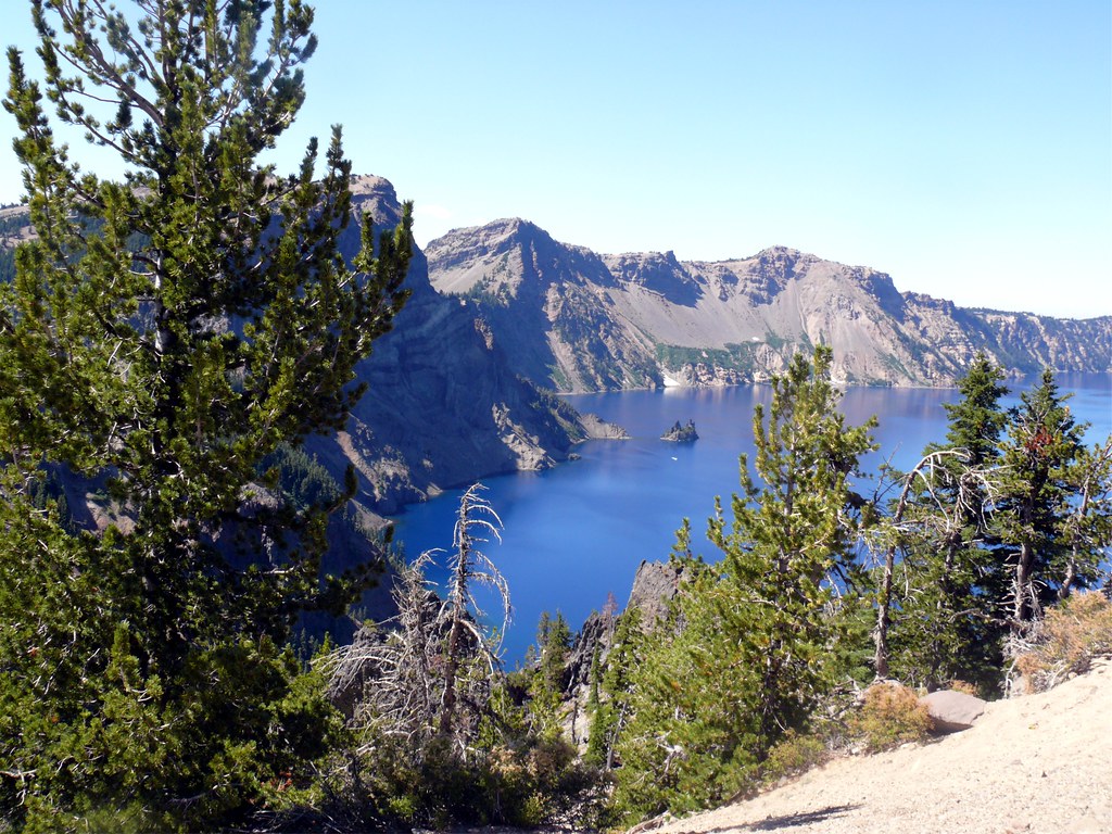
Photo: davidwilson1949 via Flickr (CC BY 2.0)
Knowing how get Crater Lake before sunrise pays off at Sinnott Memorial Overlook, where cold air spills across the rim and the water lies nearly 1,000 feet below, dark blue beneath the first light on Wizard Island. At 7,100 feet, Rim Village can feel sharply colder than the valleys, and snowbanks may remain beside the road well into summer. Reaching that view requires more planning than the map suggests. Crater Lake National Park sits in Oregon’s southern Cascade Range, away from interstate highways and major cities. Most visitors need a rental car and must choose between two seasonally different routes.
Reaching that view requires more planning than the map suggests. Crater Lake National Park sits in Oregon’s southern Cascade Range, away from interstate highways and major cities. Most visitors need a rental car, must choose between two seasonally different entrances, and should avoid relying blindly on GPS directions. Our team breaks the trip into three decisions: where to fly, which approach road to use, and how snow affects access.
How to Get to Crater Lake: Start With the Park Map
Rim Village is the practical destination
When estimating mileage, use Rim Village rather than the park boundary. The entrance signs are still a substantial drive from the first full lake view. Rim Village sits on the caldera’s southwest rim near Sinnott Memorial Overlook and the start of the paved 1.1 mile Discovery Point Trail. It is also the logical starting point for the 33 mile Rim Drive when that road is fully open.
Crater Lake occupies the collapsed summit of Mount Mazama, which erupted about 7,700 years ago. The lake surface is approximately 6,178 feet above sea level, while surrounding high points rise considerably higher. Cloudcap Overlook reaches about 7,865 feet, making Rim Drive one of Oregon’s highest paved roads. Those elevations explain why road conditions can differ dramatically from conditions in Medford or Klamath Falls.
Two entrances serve different seasons
The South Entrance, reached from Oregon Route 62, is the dependable approach for most of the year. Route 62 connects with Medford and the Rogue Valley from the west, and with US Route 97 and Klamath Falls from the south. From the entrance, Munson Valley Road climbs toward park headquarters and Rim Village.
The North Entrance connects the park with Oregon Route 138. It provides the shortest summer approach from Roseburg, Eugene, Bend, and much of central or northern Oregon. Heavy snow closes the North Entrance Road for a long winter season, however. A navigation app may continue to suggest it when gates block passage, so route planning must follow actual park road status.
How to Get to Crater Lake National Park From Nearby Airports
Medford offers the most convenient major airport
Rogue Valley International Medford Airport, identified by the code MFR, is generally the easiest airport for a dedicated Crater Lake trip. The drive to Rim Village is roughly 80 miles and usually takes about two hours without lengthy stops. The route follows Oregon Route 62 through the upper Rogue River corridor, passing communities and forested stretches near Shady Cove, Prospect, and Union Creek before reaching the South Entrance.
Medford also offers the strongest concentration of rental vehicles and trip supplies in southern Oregon. Buy food, obtain traction equipment when conditions warrant, and fill the fuel tank before climbing into the Cascades. Fuel availability closer to the park is limited and can be seasonal, while cellular coverage becomes unreliable along forested sections of Route 62.
Airport comparisons for different Oregon itineraries
| Arrival point | Approximate distance to Rim Village | Typical driving time | Best use |
|---|---|---|---|
| Medford, MFR | About 80 miles | About 2 hours | Shortest practical commercial airport approach |
| Redmond, RDM | About 145 miles | About 3 hours | Central Oregon and Bend itineraries |
| Eugene, EUG | About 165 miles | About 3.5 hours | Willamette Valley and southern Oregon road trips |
| Portland, PDX | About 250 miles | About 5 hours | Longer Oregon circuits with several stops |
Redmond becomes especially practical when the North Entrance is open. Drivers travel south on US Route 97, then turn west on Route 138 near Diamond Lake Junction. Eugene can work through Roseburg and Route 138 during the snow free season. Portland requires a substantial drive, so an overnight stop near Eugene, Roseburg, Bend, or the upper Rogue Valley can prevent arriving on mountain roads after dark.
Klamath Falls as a rail and road gateway
Klamath Falls lies about 60 miles from Rim Village and has intercity rail service, but onward transportation requires advance planning. Rental car selection is typically narrower than at a major commercial airport, and there is no dependable park wide public transportation system for general sightseeing. Confirm the vehicle pickup location and operating hours before booking a rail itinerary.
How to Get to Crater Lake by Choosing the Right Approach Road
How to Get to Crater Lake From Medford or Klamath Falls by Road
From Medford, follow Route 62 northeast through the Rogue River valley. Near Union Creek, the highway bends southeast toward the park. This approach remains below the rim for most of the trip, but the final climb gains elevation quickly. Watch for deer around dawn and dusk, particularly where the highway crosses open meadows or follows forest edges.
From Klamath Falls, take US Route 97 north, then Route 62 northwest near Chiloquin. This route approaches through drier ponderosa pine country before climbing toward Mazama Village and the South Entrance corridor. It is usually the clearest choice for travelers arriving from California via Interstate 5 and connecting through Weed, or from Reno and northeastern California through the Klamath Basin.
The summer approach from Roseburg, Bend, and Eugene
Route 138 crosses the Cascades between Roseburg and US Route 97, meeting the North Entrance Road near Diamond Lake. From Roseburg, the road follows the North Umpqua River and passes trailheads for waterfalls including Toketee Falls and Watson Falls. Curves, wildlife, and sightseeing traffic make actual travel slower than a simple mileage calculation suggests.
From Bend or Redmond, US Route 97 provides a fast north to south corridor to Route 138. This approach avoids the slower western Cascade crossings, but it only reaches the caldera directly while the North Entrance is open. During its closure, drivers must continue south toward the Route 62 connection, adding considerable time and mileage.
How to Get to Crater Lake When Snow Affects Roads and Entrances
Plan around elevation rather than the valley forecast
Crater Lake receives roughly 40 feet of snow in an average year, and the rim commonly retains deep cover after lower elevation wildflowers have emerged. The South Entrance and road to Rim Village are plowed during winter, but storms, drifting snow, and avalanche control can cause temporary closures. The North Entrance and much of Rim Drive generally remain closed from autumn into late spring or early summer.
Full Rim Drive access often arrives well after the South Entrance road has opened. Early summer visitors may reach Rim Village yet remain unable to circle the lake or drive to Cleetwood Cove, the only legal trail to the shoreline. Before leaving an area with reliable service, confirm current roads, entrance operations, fees, and traction requirements on the official park site.
A route check that prevents common mistakes
- Set Rim Village as the destination. Searching only for the national park can route you to an entrance rather than the lake.
- Check the North Entrance separately. Its closure can add hours to an approach from central or northern Oregon.
- Download offline maps. Cellular reception is inconsistent on Routes 62 and 138 and around much of Rim Drive.
- Top off the fuel tank. Do this in a larger gateway such as Medford, Klamath Falls, Roseburg, or Bend.
- Carry warm layers and water. Rim temperatures can be far lower than airport temperatures, even on clear summer mornings.
- Avoid unpaved GPS shortcuts. Forest roads may be gated, snowbound, rough, or unsuitable for rental vehicles.
Winter drivers should carry tire chains or use an appropriately equipped vehicle, even when pavement is bare in the valleys. Snow can intensify over a few miles during the climb, and shaded corners may remain icy after sunny sections have melted. Build daylight into the schedule because lane markings, junctions, and wildlife are harder to see during active snowfall.
Getting Around Crater Lake National Park Once You Reach the Caldera
Allow several hours for Rim Drive
The 33 mile Rim Drive forms the park’s primary sightseeing route when fully open. Driving the loop without stopping takes roughly one hour, but overlooks, short walks, and slow traffic easily expand the circuit to three or four hours. The eastern side is narrower and more winding, climbing to Cloudcap Overlook before passing Mount Scott, the park’s highest point at 8,929 feet. Larger vehicles require particular care around tight curves and crowded pullouts.
At Cloudcap, pale pumice shifts underfoot while wind moves across the exposed ridge with little shelter from trees. The lake fills nearly the entire view, and the opposite rim stands about six miles away. From this height, Wizard Island appears small despite rising roughly 763 feet above the water. Morning temperatures can remain cold enough for gloves even when the lower Rogue and Klamath valleys are already warm.
Plan on using your own vehicle
There is no comprehensive transit network connecting every overlook, trailhead, and entrance. A personal or rental vehicle therefore provides the practical way to reach Watchman Overlook, Cleetwood Cove, Cloudcap, Vidae Falls, and the Pinnacles Road junction. Cyclists may use roads that are legally open, but steep grades, limited shoulders, high elevation, and distracted sightseeing traffic make a complete loop physically demanding.
Choose the right vehicle size
A standard passenger car can handle paved park roads under normal summer conditions. High clearance offers little benefit unless a separate itinerary includes legal forest roads outside the park. Compact vehicles are easier to place in small overlook pullouts, while drivers of motorhomes should identify suitable stopping areas before entering the busiest sections of Rim Drive.
Build a Realistic Day Around Driving Distances
Match stops to the time available
| Time in the park | Practical route | Key limitation |
|---|---|---|
| Two hours | Rim Village, Sinnott Memorial Overlook, and Discovery Point | Insufficient time for the complete loop |
| Half day | Rim Village plus the western Rim Drive overlooks | Long hikes will crowd the schedule |
| Full day | Complete Rim Drive with selected short walks | Requires an early start during busy summer periods |
| Two days | Rim Drive plus Cleetwood Cove or Mount Scott | Trail access depends on seasonal road openings |
For a short visit, park once near Rim Village and explore on foot. Discovery Point lies west along an easy rim path, while Sinnott Memorial Overlook provides a direct view into the caldera. Drivers with a full day can continue clockwise or counterclockwise around the lake, but should choose two or three priority overlooks rather than stopping at every turnout.
Account for trail access before parking
Cleetwood Cove Trail descends about 700 feet over 1.1 miles to the shore, then regains that elevation on the return. The climb makes this a much longer stop than its mileage suggests. Mount Scott Trail covers about five miles round trip and gains roughly 1,250 feet. Starting either hike late can leave drivers completing the winding rim road in fading light.
Prepare for Delays and Route Changes
Carry what an isolated mountain drive requires
Visitors asking “How Get Crater Lake” often concentrate on the correct highway while overlooking the final hours away from larger service centers. Pack enough water and food for the day, prescription medication, sun protection, insulating layers, and a basic first aid kit. A paper Oregon highway map provides useful backup if a phone fails, while a charging cable or battery pack keeps downloaded navigation available.
- Start with a full fuel tank and adequate driving range for detours.
- Save the return route before losing cellular service.
- Keep warm clothing inside the cabin rather than buried under luggage.
- Carry a windshield scraper and gloves during the shoulder seasons.
- Tell someone which entrance and return highway you expect to use.
Know when to abandon the original plan
If weather closes the climb to Rim Village, do not wait beside a gate or attempt an unsigned forest road. Return toward a serviced highway and reassess from a location with fuel, food, and communications. Smoke from regional wildfires can also reduce visibility and make strenuous activity uncomfortable even when park roads remain open. A flexible itinerary should allow Crater Lake to move by a day rather than forcing a long mountain drive in poor conditions.
Gear & Essentials
Tell us about your trip and we will add what else you will want:
The basics
Worth having in the car whatever the park.
For this trip
Traveling with kids
Bringing a pet
RVing
Backcountry
Winter conditions
On the water
Photography
Accessibility
As an Amazon Associate we earn from qualifying purchases, at no extra cost to you.
How to Get to Crater Lake With Your Route Planned in Advance
The most reliable plan combines three choices made in advance: an airport or gateway with a suitable vehicle, an entrance that is open for the season, and enough time for the drive beyond the boundary. Medford and the South Entrance work well for many trips, while Redmond, Bend, Eugene, and Roseburg become more efficient when the North Entrance is available.
Once inside, treat Rim Village as the orientation point and Rim Drive as a mountain road rather than a quick scenic loop. Offline directions, a full tank, warm layers, and a short list of priority stops remove the most common sources of delay. With those details settled before departure, the final climb delivers you to the caldera with daylight and time to explore.
Want to keep exploring? Browse all our Crater Lake guides and articles for more trip-planning tips and ideas.