Pinnacles National Park: The Perfect Weekend Itinerary
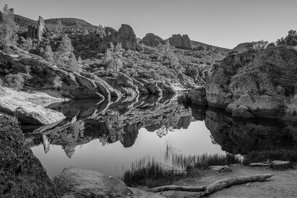
Photo: philia10 via Flickr (CC BY-NC-SA 2.0)
Pinnacles National Park: Perfect weekend planning starts with one crucial decision: use the east entrance as your base rather than trying to drive through the park. No road connects the east and west entrances. Reaching the opposite side requires a roughly 65-mile drive around the Gabilan Range, commonly taking 75 to 100 minutes.
Our two-day route concentrates on the east side, where short access roads lead to Bear Gulch, Condor Gulch, the High Peaks, and the Old Pinnacles Trail. Arrive Friday evening if possible, hike the High Peaks early Saturday, then explore the Balconies on Sunday. This sequence tackles the exposed, strenuous terrain during the coolest part of the weekend and saves a lower, more flexible route for departure day.
Pinnacles National Park: The Perfect Weekend Itinerary at a Glance
Why the east-side route works
The east entrance is reached from California Highway 25 south of Hollister. It provides access to the park campground, the visitor center area, Old Pinnacles Trailhead, and Bear Gulch. For travelers arriving from San Jose or the southern San Francisco Bay Area, the drive commonly takes about 90 minutes to two hours before weekend traffic and park congestion are considered.
Bear Gulch is the logical Saturday starting point because the 5.3-mile Condor Gulch and High Peaks loop climbs approximately 1,300 feet into the park’s steepest formations. Old Pinnacles Trailhead, about 1.7 road miles from the east visitor center area, serves Sunday’s 5.3-mile round trip to Balconies Cave. Both days begin close to the same base, eliminating an unnecessary entrance change.
Pinnacles National Park: The Perfect Two-Day Route
| Day | Stop | Primary highlight | Approximate drive time |
|---|---|---|---|
| Friday | East entrance | Campground arrival and sunset orientation | About 45 minutes from Hollister |
| Saturday morning | Bear Gulch | Condor Gulch and High Peaks loop | About 10 minutes from the campground area |
| Saturday afternoon | Bear Gulch Reservoir | Talus passages and shaded reservoir | No additional drive if linked to the morning hike |
| Sunday morning | Old Pinnacles Trailhead | Balconies Cliffs and Balconies Cave | About 5 minutes from the campground area |
| Sunday afternoon | East entrance departure | Return toward Hollister and Highway 101 connections | About 45 minutes to Hollister |
Drive times inside the park are short, but parking availability can control the morning schedule. Bear Gulch lots frequently fill on busy spring weekends, and transportation arrangements may change by season. Enter early, follow posted traffic instructions, and confirm current road, shuttle, reservation, and fee details on the official park site.
Understand the Landscape Before You Arrive
Volcanic rock shaped by a moving fault
Pinnacles protects the eroded remains of a volcano that erupted about 23 million years ago near present-day Lancaster, California. The western half of the Pinnacles volcanic field moved approximately 195 miles northwest along the San Andreas Fault. Erosion subsequently carved the breccia, rhyolite, and other volcanic rocks into spires, monoliths, narrow ravines, and the High Peaks ridge seen today.
The park’s caves are talus caves rather than limestone caverns. House-sized boulders fell into narrow gorges and formed dark chambers beneath them. Bear Gulch Cave and Balconies Cave can close temporarily because of flooding, rock hazards, or protection of sensitive wildlife, including a maternity colony of Townsend’s big-eared bats at Bear Gulch. Check cave status before choosing footwear and packing a light.
Elevation, exposure, and wildlife
Terrain rises from chaparral-covered valleys to North Chalone Peak, the park’s highest point at 3,304 feet. The High Peaks remain lower than many Sierra Nevada trails, yet the combination of direct sun, limited water, sharp elevation changes, and rough footing makes them strenuous. Spring temperatures can shift from a cool morning to exposed midday heat within a few hours.
California condors are the signature wildlife sighting. Look for them above Scout Peak, Condor Gulch, and the High Peaks, often soaring with turkey vultures. Condors have broad wings that can span roughly 9.5 feet, and numbered wing tags may be visible through binoculars. Prairie falcons, golden eagles, bobcats, gray foxes, and coast horned lizards also inhabit the park.
Essential Logistics for the Perfect Pinnacles National Park Weekend
Choose the correct entrance and sleeping base
Use the east entrance for this itinerary and enter it correctly in navigation software. Mapping applications sometimes route visitors toward the west entrance even when their campground or trailhead lies on the east side. California Highway 25 is the main approach, followed by the signed park road. Fill the fuel tank in Hollister or another established town because services become sparse south of the city.
The park campground is on the east side near the visitor center area. Reservations can be highly competitive during mild spring and autumn weekends, so confirm current booking procedures and site facilities before departure. Alternatives include lodging in Hollister, roughly 30 miles north, or accommodation near San Juan Bautista. Staying outside the park adds an early drive but provides easier access to groceries and restaurants.
Food, water, and connectivity gaps
Bring complete breakfasts, trail lunches, snacks, and enough water for both hiking days. Food choices near the entrance are limited, and returning to Hollister for supplies can consume around 90 minutes round trip. Potable-water availability and campground services can change because of maintenance or drought conditions, so verify current conditions and begin with filled containers.
Cell reception is unreliable among the volcanic ridges and can disappear in Bear Gulch, the Balconies, and sections of Highway 25. Download the park map and hiking route before leaving town. Tell someone which trailhead you are using, especially if your group plans to separate or attempt a longer route such as North Chalone Peak.
Weekend packing priorities
- Water: Carry at least two to three liters per person for the High Peaks, with more during warm weather.
- Lighting: Pack one headlamp per hiker for Bear Gulch or Balconies Cave.
- Footwear: Use shoes with dependable traction for polished rock, loose gravel, and steep steps.
- Sun protection: Bring a brimmed hat, sunscreen, and lightweight long sleeves because shade is limited above the valleys.
- Navigation: Download an offline map and carry the printed park map as backup.
- Wildlife viewing: Bring binoculars for identifying condors without approaching roosting or nesting areas.
Saturday: Bear Gulch and the High Peaks
Start with the Condor Gulch climb
Begin at Bear Gulch shortly after access becomes available and follow Condor Gulch Trail toward the High Peaks. The climb gains elevation steadily through chamise, gray pine, buckwheat, and seasonal wildflowers. Condor Gulch Overlook provides an early view into the volcanic formations, but the strongest panoramas come higher, where the trail reaches the ridge near Scout Peak.
Complete the 5.3-mile loop by continuing across the High Peaks and descending toward Bear Gulch. Allow three to five hours, depending on heat, crowding, and time spent watching condors. Hikers uncomfortable with heights can use the signed Tunnel Trail alternative, which bypasses the narrowest section while preserving much of the ridge scenery.
The Steep and Narrow section
The upper High Peaks Trail crosses carved footholds, tight ledges, and short staircases protected by metal handrails. Trekking poles become awkward here and may need to be stowed. Move one person at a time through constricted passages, keep hands free, and avoid stopping where other hikers cannot pass safely.
Finish Saturday Below the High Peaks
Descend to Bear Gulch Reservoir
From the ridge, follow the High Peaks Trail toward the Rim Trail and Bear Gulch Reservoir. The descent crosses open chaparral before entering cooler oak woodland near the water. Bear Gulch Reservoir was created by a small dam built by the Civilian Conservation Corps in the 1930s. Its stonework blends into the surrounding volcanic gorge, making the shoreline a useful lunch stop after the exposed ridge. Swimming and wading are prohibited, so use the reservoir for rest and photography rather than cooling off.
Add Bear Gulch Cave only when conditions allow
Bear Gulch Cave can be incorporated into the descent when the cave route is open. The passage involves low ceilings, damp steps, narrow spaces, and sections where both hands may be helpful. A headlamp is preferable to a phone light because water, uneven rock, and other hikers demand steady illumination. Cave access changes with flooding and the seasonal needs of Townsend’s big-eared bats, so follow closure signs even if a downloaded map shows the route as open.
When to skip the cave
Use the Moses Spring Trail bypass if the cave is closed, crowded, or unsuitable for anyone in your group. This aboveground route follows the same gorge without requiring crawling or negotiating dark chambers. After returning to Bear Gulch, reserve the late afternoon for recovery at camp rather than adding North Chalone Peak. That summit extension adds several demanding miles and fits better into a three-day visit.
Sunday: Balconies Cave and the Old Pinnacles Trail
Walk the shaded canyon first
Begin at Old Pinnacles Trailhead and follow the Old Pinnacles Trail west through Chalone Creek’s broad canyon. The relatively gentle opening miles contrast with Saturday’s sustained climbing, although sand, loose gravel, and seasonal creek crossings still slow progress. Morning light reaches the canyon gradually, providing cooler conditions and a better chance of seeing woodpeckers, quail, or deer near the riparian vegetation. Carry all required water because dependable drinking water is generally unavailable along the route.
Choose the cave or cliff route at the Balconies
Near the Balconies formation, the route divides between Balconies Cave Trail and Balconies Cliffs Trail. The cave route enters a talus passage where scrambling and tight footing may be required. The cliffs route climbs above the gorge for open views of Machete Ridge and the massive rock walls. Combining the two creates a varied loop before retracing Old Pinnacles Trail, with the complete outing totaling about 5.3 miles.
Must-do route versus optional detour
- Essential: Reach the Balconies junction and complete whichever branch matches current conditions and group ability.
- Best cave alternative: Take Balconies Cliffs Trail when high water, darkness, or tight spaces are concerns.
- Optional extension: Continue toward the west-side Chaparral area only if time and energy permit, remembering that you must hike back to the east-side vehicle.
- Departure target: Return by early afternoon to leave time for the drive toward Hollister and busier Highway 101 corridors.
Adjust the Route for Heat, Rain, and Daylight
Seasonal route decisions
Spring commonly provides mild hiking temperatures, green slopes, and wildflowers such as shooting stars, larkspur, and California poppies. It also brings the busiest weekends and possible cave closures associated with bat protection. Summer temperatures regularly make exposed trails hazardous by late morning. Autumn generally offers cooler mornings but dry vegetation and limited creek water. Winter can deliver excellent visibility between storms, although rain may flood caves and make polished talus slippery.
| Season | Start strategy | Primary adjustment |
|---|---|---|
| Spring | Arrive before peak parking demand | Check cave and wildlife closures |
| Summer | Begin hiking near first light | Shorten exposed ridge mileage |
| Autumn | Use cool morning hours | Carry extra water in dry conditions |
| Winter | Wait for safe post-storm conditions | Use aboveground cave bypasses |
A heat-safe alternative
When the forecast calls for significant heat, reverse the weekend’s emphasis rather than forcing the complete High Peaks loop. Hike Condor Gulch only to the overlook, return to Bear Gulch, and spend the remaining cool hours on Moses Spring Trail. Begin the Balconies outing earlier Sunday and turn around before the gorge if temperatures rise quickly. Confirm current weather, fire restrictions, trail closures, and water availability on the official park site before leaving reliable cell coverage.
Complete Your Perfect Pinnacles National Park Weekend Itinerary
The strongest two-day schedule keeps one vehicle on the east side, places the High Peaks during Saturday’s coolest hours, and saves the gentler Old Pinnacles corridor for Sunday. That order limits unnecessary driving while covering the park’s defining experiences: volcanic spires, condor habitat, talus caves, Bear Gulch Reservoir, and the Balconies. It also leaves practical exit time for fuel, food, and the return through Hollister.
Pinnacles National Park: Perfect weekend execution depends on early starts and disciplined preparation. Download maps, fill the tank, carry complete meals, and check cave status before arrival. Treat North Chalone Peak and a west-side visit as future-trip options rather than squeezing them into two days. With those choices settled in advance, the weekend remains ambitious without becoming rushed, even when parking, heat, or wildlife closures require a change of route.
Want to keep exploring? Browse all our Pinnacles guides and articles for more trip-planning tips and ideas.
Gear & Essentials
Before you head out, make sure you have the right gear for Pinnacles National Park: The Perfect Weekend Itinerary. These are our picks:
- TrailBuddy Aluminum Trekking Poles
- IRON FLASK Insulated Hiking Flask 32oz
- Hydration Water Bladder 2L BPA-Free
- BAND-AID Travel Emergency First Aid Kit
- Merrell Men's Moab 3 Hiking Shoe
- Merrell Women's Moab 3 Mid Waterproof Boot
As an Amazon Associate, we earn from qualifying purchases at no extra cost to you.