Visiting Crater Lake National Park with Limited Mobility: Accessible Views and Trails
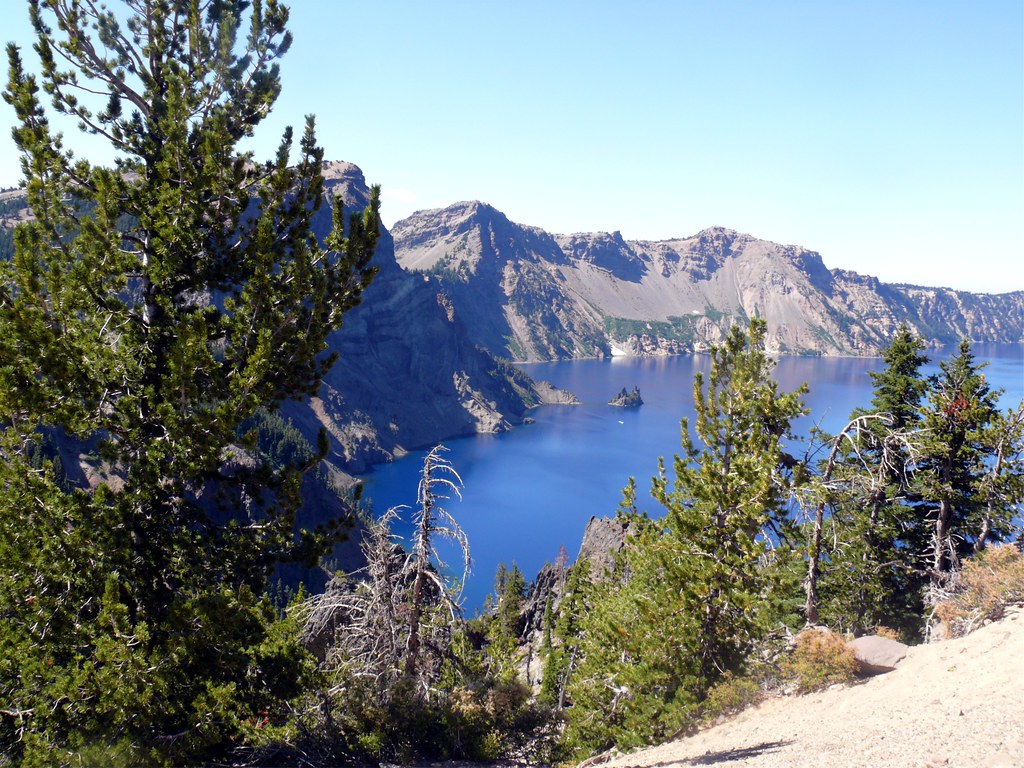
Photo: davidwilson1949 via Flickr (CC BY 2.0)
Visiting Crater Lake National Park with limited mobility is practical because several of the caldera’s strongest views are visible from paved plazas or short approaches near Rim Drive. A visitor does not need to descend toward the lake or complete a conventional hiking trail to see Wizard Island, Phantom Ship, Mount Scott, or the sheer inner walls. The main challenge is planning around snow, elevation, uneven historic paving, and the long distances between developed areas.
Crater Lake occupies the collapsed summit of Mount Mazama in southern Oregon’s Cascade Range. The lake surface sits at approximately 6,178 feet, while much of the rim rises above 7,000 feet. At 1,943 feet deep, it is the deepest lake in the United States. That scale matters for accessibility: the accessible experience happens primarily along the rim, while the only trail to the shore is exceptionally steep.
Visiting Crater Lake National Park with Limited Mobility: What to Expect
Most visitors enter from Oregon Route 62 and climb to Rim Village, the principal viewing area on the caldera’s south side. The approximately 33-mile Rim Drive circles the lake, but deep snow keeps substantial portions closed for much of the year. When the full road is open, a vehicle becomes the best mobility tool in the park, linking overlooks that reveal different parts of the caldera without requiring long walks.
The caldera rewards short, carefully chosen stops
Mount Mazama collapsed after a massive eruption about 7,700 years ago, leaving a basin roughly 5 miles wide. Rain and snowmelt subsequently filled it. No rivers flow into or out of the lake, contributing to its exceptional clarity and intense blue color. Wizard Island is a cinder cone that formed during later eruptions inside the caldera, while Phantom Ship is a resistant ridge of ancient lava rising above the water near the southeastern shore.
Why reaching the water is a separate undertaking
Cleetwood Cove Trail is the only legal route to the lakeshore. The trail descends about 700 vertical feet in 1.1 miles, then requires the same climb back to the rim. Its steep grades, loose volcanic surface, switchbacks, and high elevation make it unsuitable for wheelchairs and difficult for many people with joint, balance, cardiac, or respiratory limitations. Fortunately, the most complete lake panoramas are obtained from the rim rather than the shore.
Accessibility varies within the same developed area
A paved overlook may still include cross slopes, cracked surfaces, curbs, or a gradual climb from the parking area. Snowbanks can narrow routes well after roads reopen, and historic structures were often built before modern accessibility standards. Wheelchair users should distinguish between a roadside viewpoint, a paved pedestrian route, and a trail described merely as “easy.” Current road openings, facility availability, entrance fees, and accessibility updates should be confirmed on the official park site.
How to Orient Your Visit to Crater Lake National Park with Limited Mobility
Rim Village provides the simplest first view and the greatest concentration of visitor services. From there, Rim Drive separates into western and eastern routes around the lake. The western side reaches Discovery Point, Watchman Overlook, and North Junction. The eastern side serves Cloudcap, Pumice Castle, Phantom Ship Overlook, Vidae Falls, and the turnoff toward the Pinnacles. Distances are manageable by car, but repeated transfers can become tiring.
Visiting Crater Lake National Park from the south
The south entrance is generally the most dependable approach because the highway corridor toward Rim Village is plowed during the winter season, although storms can still cause difficult or temporary closure conditions. Approaching from Medford or Klamath Falls involves mountain highways with long sections lacking services. Fuel, food, medication, and mobility equipment should be secured before the final climb into the park.
Rim Village as the first decision point
Begin at the paved Rim Village area and assess wind, temperature, visibility, and walking surfaces before committing to a longer circuit. Conditions on the rim can feel considerably colder than at the entrance. If clouds conceal the opposite wall, waiting may help because fog can move quickly. If the western road is open but the full loop is closed, Discovery Point and Watchman Overlook still create a worthwhile out-and-back drive.
A low-exertion sequence for the day
- Use Rim Village for the first broad caldera view and an unhurried mobility assessment.
- Drive west to Discovery Point for a different angle across Wizard Island.
- Continue to Watchman Overlook if road and parking conditions allow.
- Return for a rest before adding the longer eastern rim circuit.
- Limit transfers by grouping nearby overlooks rather than stopping at every pullout.
Visiting Crater Lake National Park with Limited Mobility: Accessible Views
Accessibility at Crater Lake is strongest where the road approaches the caldera edge. The following locations require far less exertion than summit trails such as Garfield Peak, Mount Scott, or Watchman Peak. Parking availability and the precise condition of pedestrian surfaces can vary, but these stops form the core of a limited-mobility itinerary when Rim Drive is fully open.
| Viewpoint | Primary sight | Typical approach | Key consideration |
|---|---|---|---|
| Rim Village | Wizard Island and western caldera | Paved plaza and rim paths | Some sections slope or become snow-covered |
| Discovery Point | Broad lake panorama | Short approach from parking | Nearby hiking trail has exposed edges |
| Watchman Overlook | Wizard Island from above | Roadside viewing area | The Watchman Peak Trail is steep |
| Cloudcap Overlook | Expansive eastern-rim perspective | Drive-up spur near 7,865 feet | Usually accessible only during the short snow-free season |
| Phantom Ship Overlook | Phantom Ship and southeastern cliffs | Short roadside stop | Small rock formations can be difficult to identify in haze |
Rim Village and the caldera’s sudden reveal
From the parking area, the ground rises gently toward the rim, with patches of rough pavement and volcanic gravel underfoot. Then the land drops away almost vertically. The opposite wall stands several miles across the water, snow lingering in shaded gullies even during summer. Wind crosses the exposed rim without obstruction, and conversations become quieter as people register the lake’s scale. A bench or stable stopping point helps because the first view encourages a longer pause than the map suggests.
Discovery Point and Watchman Overlook
Discovery Point commemorates the place where prospectors reported seeing the lake in 1853. The roadside area gives a strong view toward Wizard Island without requiring the adjoining Discovery Point Trail, which follows the rim for roughly 2 miles and includes narrow, uneven sections near drop-offs. Farther west, Watchman Overlook looks almost directly down on Wizard Island. The separate Watchman Peak Trail climbs approximately 420 feet and should not be confused with the lower-effort roadside viewpoint.
Snow, Elevation, and the Short Rim Drive Season
Crater Lake receives extraordinary snowfall, historically averaging more than 40 feet in a year at park headquarters. Snow can fall during any month, and banks often remain beside Rim Drive into July. The complete loop commonly has a much shorter operating season than lower-elevation roads in Oregon. Visitors who depend on drive-up overlooks gain the widest selection in late summer and early autumn, before the first sustained storms close exposed sections.
Visiting Crater Lake National in summer and early fall
July through September usually provides the best chance of reaching Cloudcap, Phantom Ship Overlook, and other eastern-rim stops by vehicle. Afternoon haze from regional wildfire smoke can obscure distant details, while morning often brings calmer air and easier parking. Early autumn can provide sharper visibility and fewer insects, but overnight freezing temperatures become increasingly likely. A clear forecast in a nearby valley does not guarantee clear conditions at the rim.
Cold-weather limitations begin at the parking space
Winter and spring visits concentrate around the plowed approach to Rim Village. Snowbanks may block familiar summer sightlines, packed snow can make paved routes slippery, and blowing snow can erase the lake within minutes. At elevations above 7,000 feet, some visitors also notice shortness of breath during brief walks. Move slowly, allow extra time for transfers, and carry traction aids compatible with the user’s footwear or mobility device.
Short Trails Beyond the Caldera Rim
Two lower elevation trails provide alternatives when wind, exposure, or congestion makes the rim uncomfortable. Both begin from the southern portion of the park and explore landscapes created by Mount Mazama’s eruption. They also offer shade that is largely absent from the caldera overlooks. Trail surfaces can collect needles, pumice, and small branches, so wheelchair users may need assistance even where grades meet accessible design standards.
Godfrey Glen Trail
Godfrey Glen Trail forms an approximately 1.1 mile loop through old growth forest near Mazama Village. The trail was designed for accessibility, with a broad, compacted surface and relatively gentle grades. Openings along the route reveal Annie Creek Canyon, where erosion carved narrow ridges into deposits from Mount Mazama’s climactic eruption. Mountain hemlock, lodgepole pine, and Shasta red fir provide shade. This is the strongest trail choice for visitors who want a forest experience without steep climbing.
Plaikni Falls Trail
Plaikni Falls Trail runs about 2 miles round trip from Pinnacles Road. Its first three quarters of a mile are accessible, passing through forest and wildflower habitat with modest elevation change. The final approach becomes steeper and rougher before reaching the waterfall, which drops from a snow fed spring beneath Anderson Bluffs. Visitors can turn around where the grade becomes uncomfortable. Summer mosquitoes can be persistent, and lingering snow or runoff may affect the surface early in the season.
| Trail | Distance | Surface and grade | Best reason to choose it |
|---|---|---|---|
| Godfrey Glen | About 1.1 miles | Compacted loop with gentle grades | Accessible forest route and canyon views |
| Plaikni Falls | About 2 miles round trip | Accessible first section, steeper near the falls | Wildflowers, shade, and flowing water |
Managing Energy, Transfers, and Exposure
Visiting Crater Lake National Park with limited mobility often involves balancing short walks against repeated vehicle transfers. A full Rim Drive circuit can take several hours once rest stops, photographs, and slow traffic are included. Select three or four priority viewpoints rather than treating every pullout as mandatory. Cloudcap, the road’s highest vehicle accessible point, requires particular care because its elevation of approximately 7,865 feet can intensify fatigue and breathlessness.
Build recovery time into the route
Plan a seated break after every two stops, especially for anyone who uses crutches, a walker, or portable oxygen. Keep water, medication, sun protection, and an extra insulating layer inside the passenger compartment rather than buried beneath luggage. The lake’s intense reflected light can cause sunburn even when the air feels cold. Dehydration also develops quietly at elevation, particularly when low temperatures reduce the urge to drink.
A practical vehicle kit
- A firm seat cushion for low or uneven benches
- Wheel chocks for safe transfers on sloping parking areas
- Gloves that improve grip on cold wheelchair rims or walking aids
- A compact blanket and wind resistant outer layer
- Food and water sufficient for delays between developed areas
Know which famous stops demand extra effort
Sinnott Memorial Overlook sits below Rim Village and is reached by a steep, historic walkway with stairs, making it unsuitable for many mobility devices. The Pinnacles Trail is comparatively level but follows exposed terrain and may present surface or edge concerns. Garfield Peak, Mount Scott, and Watchman Peak all require sustained climbing. Choosing roadside perspectives preserves energy for Godfrey Glen or another route built around a visitor’s actual mobility range.
Planning a Crater Lake Visit Around Your Abilities
The most effective limited mobility itinerary begins at Rim Village, continues only as far around Rim Drive as comfort and weather permit, and includes a lower elevation forest stop on the return. Prioritize Discovery Point for Wizard Island, Phantom Ship Overlook for the caldera’s southeastern formations, and Cloudcap when elevation tolerance is established. This sequence captures the lake’s volcanic structure from several angles without relying on demanding trails.
Allow flexibility for wind, smoke, snow, and fatigue. Crater Lake’s defining features remain visible from places reached by vehicle, while Godfrey Glen adds an accessible trail through the eruption shaped landscape below the rim. With carefully limited transfers, realistic turnaround points, and equipment suited to cold and uneven surfaces, visitors can experience the park’s scale and geology without descending to the water or attempting a summit route.
Want to keep exploring? Browse all our Crater Lake guides and articles for more trip-planning tips and ideas.
Gear & Essentials
Tell us about your trip and we will add what else you will want:
The basics
Worth having in the car whatever the park.
For this trip
Traveling with kids
Bringing a pet
RVing
Backcountry
Winter conditions
On the water
Photography
Accessibility
As an Amazon Associate we earn from qualifying purchases, at no extra cost to you.