The National Parks of Colorado: A Guide to All 4
Our National Parks Colorado Guide starts with a useful reality: Colorado’s four national parks protect landscapes that share almost nothing except elevation and dramatic scale. Rocky Mountain reaches 14,259 feet on Longs Peak, Great Sand Dunes holds the tallest dunes in North America, Mesa Verde preserves centuries of Ancestral Pueblo history, and Black Canyon of the Gunnison compresses a powerful river into one of the continent’s steepest, narrowest gorges.
Seeing all four requires a road trip of roughly 800 miles, depending on the route and overnight stops. Our team uses this guide to explain what distinguishes each park, how their main areas fit together, which signature experiences deserve priority, and how much time each landscape needs.
Colorado’s Four National Parks at a Glance
Four Parks, Four Reasons to Visit
Rocky Mountain National Park contains Colorado’s most accessible alpine tundra and a dense network of mountain trails. Great Sand Dunes combines a 30 square mile dune field with wetlands, grasslands, forests, and 13,000 foot peaks. Mesa Verde centers on Indigenous history and architecture rather than long wilderness hikes. Black Canyon rewards visitors with overlooks above a gorge that reaches roughly 2,000 feet deep.
| Park | Defining feature | Signature experience | Useful first visit |
|---|---|---|---|
| Rocky Mountain | Alpine peaks and tundra | Trail Ridge Road and Bear Lake trails | 2 to 3 days |
| Great Sand Dunes | North America’s tallest dunes | Climbing the dune field | 1 to 2 days |
| Mesa Verde | Ancestral Pueblo cliff dwellings | Cliff Palace and Mesa Top Loop | 1 to 2 days |
| Black Canyon of the Gunnison | Deep, narrow Precambrian gorge | South Rim overlooks | 1 day |
Building a Logical Route
A practical circuit from Denver usually begins at Rocky Mountain, continues south to Great Sand Dunes, turns west toward Mesa Verde, and then travels north to Black Canyon. Approximate drives between the parks range from three to six hours. Mountain passes, construction, snow, and wildlife can lengthen them considerably, so we avoid treating a transfer day as a full sightseeing day.
- Rocky Mountain to Great Sand Dunes: approximately 250 miles
- Great Sand Dunes to Mesa Verde: approximately 200 miles
- Mesa Verde to Black Canyon’s South Rim: approximately 150 miles
- Black Canyon to Denver: approximately 260 miles
Summer brings the broadest road access, but also afternoon thunderstorms, crowded trailheads, and intense ultraviolet exposure. Spring runoff controls Medano Creek at Great Sand Dunes, while autumn produces golden aspen in Rocky Mountain and quieter roads elsewhere. Winter transforms every park differently. Expect snow travel in the high country, cold shaded conditions inside Black Canyon, and large temperature swings on the dunes. Fees, timed entry systems, ranger tour reservations, and seasonal road openings can change, so confirm current details on the official park sites.
Rocky Mountain National Park from Forest to Tundra
The Main Corridors
Most first visits divide between the Bear Lake corridor and Trail Ridge Road. Bear Lake sits at 9,475 feet and provides access to Dream Lake, Emerald Lake, Lake Haiyaha, and Flattop Mountain. The 3.6 mile round trip to Emerald Lake gains about 600 feet, but altitude makes the climb feel harder than the numbers suggest. Moraine Park and Horseshoe Park offer lower elevation meadow scenery where elk are commonly seen around dawn and dusk.
Trail Ridge Road and the Alpine Tundra
Trail Ridge Road crosses the Continental Divide and reaches 12,183 feet, carrying drivers above treeline into a landscape of cushion plants, patterned ground, and persistent wind. Short paths near Rock Cut and the Alpine Visitor Center reveal how quickly exertion increases at this elevation. Pikas shelter among talus, while elk sometimes graze on open tundra. Snowfields can remain into summer, and exposed overlooks may be markedly colder than the valleys.
Choosing a Hike That Fits the Elevation
Visitors arriving from near sea level should begin with lakes and meadows rather than committing immediately to Longs Peak or another major summit. Longs Peak rises to 14,259 feet, and the standard Keyhole Route covers about 15 miles with roughly 5,000 feet of elevation gain. It involves exposed scrambling and rapidly changing weather. For a moderate alternative, the 3.5 mile Cub Lake route crosses willow habitat and recovering burn areas without reaching the park’s highest elevations.
Great Sand Dunes Between Mountains and Sky
A Dune Field Built by Wind and Water
The dunes formed where sand carried across the San Luis Valley accumulated against the Sangre de Cristo Mountains. Opposing winds repeatedly pushed the grains back toward the mountain front, building dunes that rise about 750 feet above their base. High Dune on First Ridge is the usual objective from the main access area, while Star Dune requires a longer walk across shifting sand. Distances are deceptive because there are no fixed trails across the dune field.
What the Climb Actually Feels Like
Each step sinks several inches, and the ridge ahead often conceals another slope. Dry grains slide around the ankles, the air becomes cooler when a cloud crosses the sun, and wind erases footprints within minutes. From a high ridge, the geometric dune crests drop toward the flat San Luis Valley while the Sangre de Cristo peaks rise abruptly behind you. The open scale makes hikers look much closer than they are.
Medano Creek
Medano Creek flows along the eastern foot of the dunes, usually reaching its strongest seasonal flow during snowmelt. Under favorable conditions, underwater sand ridges create rhythmic waves known as surge flow. Water levels can fall quickly as summer advances. Beyond the creek, the park protects montane forest, alpine terrain, and wetlands used by elk, mule deer, black bears, and more than 200 recorded bird species.
Sand temperatures can become hazardous on sunny afternoons, even when the air feels comfortable. We favor an early start, closed footwear, sun protection, and at least two liters of water per person for an extended dune hike. Lightning is the greater concern when summer storms form because the dune field offers no shelter. Sandboarding and sand sledding require equipment designed for dry sand rather than ordinary snow gear.
Mesa Verde and Black Canyon Across Western Colorado
Mesa Verde’s Cultural Landscape
Mesa Verde protects nearly 5,000 known archaeological sites, including about 600 cliff dwellings associated with Ancestral Pueblo communities. People lived in the region for more than seven centuries, first occupying mesa top settlements and later constructing masonry villages within sandstone alcoves. Cliff Palace contains roughly 150 rooms and 23 kivas, making it the park’s largest cliff dwelling. Many interior sites are reached only on scheduled ranger led tours.
Driving the Mesa Top and Cliff Palace Areas
The park road climbs more than 2,000 feet from the entrance before reaching the principal archaeological areas, so the entrance sign is still a substantial drive from the major sites. Mesa Top Loop reveals the chronological development of pithouses, pueblos, reservoirs, and ceremonial spaces. Stops overlooking Square Tower House and Cliff Palace help visitors understand how alcove dwellings related to farms, water sources, and communities on the mesa above.
Black Canyon of the Gunnison
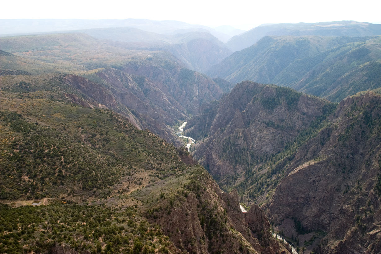
Black Canyon exposes Precambrian gneiss and schist that began forming nearly two billion years ago. The Gunnison River later cut through this resistant rock, producing walls so steep that parts of the gorge receive little direct sunlight. Painted Wall, Colorado’s highest cliff, rises approximately 2,250 feet and is streaked with pale pegmatite intrusions. The South Rim provides the most straightforward first visit through a sequence of short walks and roadside viewpoints.
Overlooks That Reveal the Gorge’s Scale
Gunnison Point, Chasm View, Painted Wall View, and Sunset View show different combinations of river, cliff, and narrow canyon. Warner Point Trail adds a 1.5 mile round trip across pinyon and juniper woodland to broad views of the canyon and San Juan Mountains. The North Rim is quieter and more primitive, with close perspectives from overlooks such as Chasm View and Exclamation Point, but reaching it requires a separate approach rather than a short drive across the canyon.
Quieter Corners Beyond the Signature Stops
The busiest corridors provide the clearest introduction to each park, but several secondary areas reveal landscapes that short visits miss. These places require extra driving or trail time, so they work best after the primary sights. They also demand greater self sufficiency because water, shade, and nearby services may be limited.
Wild Basin and Mosca Pass
In Rocky Mountain’s southeastern corner, Wild Basin follows the North St. Vrain drainage through spruce and fir forest. The roughly 5.4 mile round trip to Ouzel Falls passes Copeland Falls and Calypso Cascades, gaining about 960 feet. At Great Sand Dunes, Mosca Pass Trail leaves the exposed sand for a wooded route into the Sangre de Cristo foothills. The trail covers about seven miles round trip and provides cooler conditions than the dune field.
Petroglyph Point and the East Portal
Mesa Verde’s Petroglyph Point Trail forms a rugged 2.4 mile loop near Spruce Tree House. Stone steps, narrow ledges, and a petroglyph panel distinguish it from the park’s paved overlooks. At Black Canyon, East Portal Road descends toward the Gunnison River on grades reaching 16 percent. The road reveals the depth of the gorge from below, but sharp curves and vehicle restrictions make it unsuitable for some longer vehicles.
Matching the Parks to Colorado’s Seasons
Elevation creates different seasons within the same road trip. A warm afternoon at Mesa Verde can coincide with freezing wind on Rocky Mountain’s tundra. Great Sand Dunes has particularly sharp daily swings because dry air and exposed sand heat quickly after sunrise, then lose warmth after sunset. Black Canyon’s rim can remain pleasant while shaded trails hold snow or ice.
A Seasonal Comparison
| Period | Strongest opportunities | Conditions to plan around |
|---|---|---|
| March through May | Lower elevation hiking and rising Medano Creek | Snow in alpine areas and variable mountain roads |
| June through August | Broadest high country access | Heat, thunderstorms, crowds, and exposed terrain |
| September through October | Cool hiking weather and changing aspen | Early snow and cold nights |
| November through February | Snow travel, solitude, and clear winter light | Seasonal road closures and limited daylight |
Planning Around Thunderstorms
Summer storms commonly build after midday, especially along the Continental Divide and Sangre de Cristo Mountains. Lightning can reach exposed tundra, dune ridges, canyon rims, and mesa tops before rain arrives. Schedule Trail Ridge Road walks and extended dune climbs early, then reserve afternoons for museums, scenic drives, or lower forest trails. If thunder is audible, leave exposed ground rather than sheltering beneath an isolated tree.
Turning Four Parks Into One Manageable Trip
A seven day circuit allows only the defining experience in each park and requires several long transfers. Ten to twelve days create room for elevation adjustment, ranger guided archaeology, a longer dune hike, and weather delays. Our National Parks Colorado Guide favors sleeping near the next morning’s objective because early starts improve parking options and reduce exposure to heat and thunderstorms.
A Practical Allocation of Time
- Allow three nights around Rocky Mountain for Bear Lake, the tundra corridor, and one quieter trail.
- Use one or two nights near Great Sand Dunes, including an early morning on the sand.
- Set aside two nights for Mesa Verde because the entrance road and archaeological loops consume much of a day.
- Reserve one night near Black Canyon, adding another if visiting both rims.
Gear That Works Across All Four Parks
Pack for elevation rather than the forecast in the nearest town. Useful equipment includes a waterproof shell, insulating layer, brimmed hat, high protection sunscreen, and footwear that handles sand, loose stone, and wet forest tread. Carry more water than expected between western Colorado stops. Binoculars help observers maintain distance from elk, bears, and bighorn sheep, while an offline map remains useful where cellular coverage disappears.
Protecting Archaeological and Natural Resources
Remain on established routes around cliff dwellings, petroglyphs, fragile tundra, and biological soil crusts. Do not touch masonry or rock art, and leave pottery fragments where they lie because their location provides archaeological context. On the dunes, pack out food scraps that attract wildlife. At canyon overlooks, keep children close because many drop offs are abrupt and natural rock edges can crumble.
Gear & Essentials
Tell us about your trip and we will add what else you will want:
The basics
Worth having in the car whatever the park.
For this trip
As an Amazon Associate we earn from qualifying purchases, at no extra cost to you.
Choosing Your Colorado National Park Journey
Colorado’s four parks reward different priorities. Rocky Mountain suits travelers seeking alpine hiking and wildlife, Great Sand Dunes delivers an unusual landscape shaped by wind and water, Mesa Verde requires time for cultural interpretation, and Black Canyon concentrates immense geology into a compact rim drive. Selecting one primary experience in each park produces a stronger itinerary than rushing through every overlook and trail.
Build the route around elevation, seasonal access, and realistic transfer days. Add quieter areas only where the schedule leaves enough daylight and energy, particularly at Wild Basin, Petroglyph Point, or the Black Canyon river corridor. With those choices made before departure, the circuit becomes a coherent journey through Colorado’s alpine, desert, cultural, and canyon landscapes.