The Ultimate Kings Canyon National Park Guide for First-Time Visitors

Photo: blakeecarroll2015 via Flickr (CC0 1.0 (Public Domain))
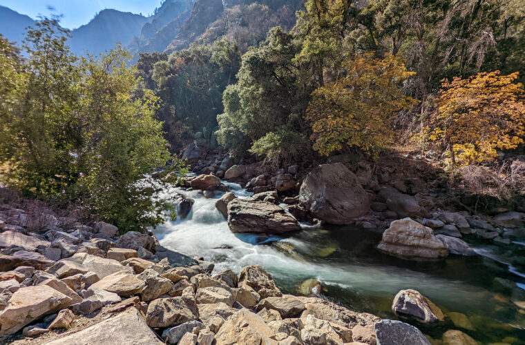
The Ultimate Kings Canyon National Park Guide for First-Time Visitors starts at sunrise beside the South Fork of the Kings River near Zumwalt Meadow, where cold air settles beneath granite walls and moving water covers the sound of footsteps. The canyon floor feels enclosed here. Pines rise overhead, pale cliffs catch the first light, and the road ends only a few miles upstream beneath peaks that exceed 11,000 feet.
Kings Canyon combines giant sequoia groves, a glacier-carved canyon, rushing Sierra rivers, and an immense roadless interior. Most first visits follow Highway 180 through two developed areas, Grant Grove and Cedar Grove. Understanding the distance and elevation between them is essential because they feel like separate parks and require different seasonal plans.
Two landscapes define Kings Canyon
Kings Canyon National Park covers more than 460,000 acres on the western slope of California’s Sierra Nevada. Its accessible areas occupy only a narrow portion of that terrain. Roads reach Grant Grove and the South Fork of Kings Canyon, while most of the park remains designated wilderness crossed by trails such as the John Muir Trail and Pacific Crest Trail.
Grant Grove protects an ancient sequoia community
Grant Grove sits at roughly 6,500 feet among mixed conifer forest. Giant sequoias grow here with white fir, sugar pine, incense cedar, and ponderosa pine. The General Grant Tree, approximately 268 feet tall, ranks among the largest living trees by wood volume. Its trunk remains broad high above the ground, a characteristic that separates mature sequoias from many tapering conifers.
The grove also demonstrates how fire shapes sequoia habitat. Heat opens cones and exposes mineral soil where seeds can germinate, while low and moderate intensity fires reduce competing vegetation. Visitors may see blackened cavities and old burn scars on living trees. Thick, fibrous bark helps mature sequoias survive heat that kills thinner-barked species.
Cedar Grove occupies the canyon’s glacial trough
Cedar Grove lies around 4,600 feet along the South Fork of the Kings River. During the Ice Age, glaciers widened this section into a broad U-shaped valley bordered by granitic cliffs. The river later deposited sand, gravel, and rounded cobbles across the canyon floor. This geology explains the sharp transition from narrow road cuts to open meadows and level forest near Zumwalt Meadow.
The landscape changes again toward Roads End, where Highway 180 stops and wilderness trails continue toward Mist Falls, Paradise Valley, and the Rae Lakes basin. North Palisade, the park’s highest summit at 14,248 feet, rises far beyond the road corridor. Reaching that alpine interior requires backpacking rather than scenic driving.
Plan around one long mountain corridor
Highway 180 is the organizing line for a first visit. It reaches Grant Grove from California’s Central Valley, crosses forested ridges, and then descends through Sequoia National Forest into Kings Canyon. The highway eventually reenters the national park near Cedar Grove and ends at Roads End. Curves, steep grades, wildlife, and overlook stops make map distances slower than they appear.
Approaching from Fresno and the Central Valley
Fresno is the principal gateway, about 55 miles from Grant Grove by way of State Route 180. Allow roughly 90 minutes in ordinary conditions, with additional time for mountain traffic or road work. The route climbs quickly from agricultural lowlands into oak woodland and conifer forest. Arrive with adequate fuel and basic food, since services become limited as the road gains elevation.
Drivers combining Kings Canyon with Sequoia National Park can use the Generals Highway between Grant Grove and Giant Forest. The road is winding and slow, so visiting both parks in a single day leaves little time for trails. A better first trip assigns one day to Grant Grove and the canyon, then a separate day to Giant Forest, Moro Rock, and the southern part of Sequoia.
Distances that shape the day
| Destination | Approximate elevation | Distance from Grant Grove | Planning significance |
|---|---|---|---|
| General Grant Grove | 6,500 feet | About 1 mile | Short walks among giant sequoias |
| Cedar Grove | 4,600 feet | About 35 miles | River access and canyon floor scenery |
| Roads End | 5,000 feet | About 41 miles | Trailheads for Mist Falls and wilderness routes |
The drive from Grant Grove to Roads End generally requires at least 75 minutes without extended stops. Junction View, canyon pullouts, Grizzly Falls, and river access can easily turn it into a half-day journey. Begin with a full tank, carry drinking water, and avoid scheduling a fixed dinner or lodging check-in immediately after the return drive.
Season determines how much of the park is reachable
Grant Grove is approached by a maintained mountain highway and is generally accessible throughout the year, although snowstorms can require chains and temporarily disrupt travel. The road to Cedar Grove normally closes for winter because it crosses avalanche terrain and steep canyon slopes. Opening and closing dates vary with snowpack, runoff, rockfall, and repairs.
Current entrance fees, campground reservations, road status, chain requirements, wilderness permits, and concession operations can change. Confirm current details on the official park site before leaving the Central Valley, especially if Cedar Grove is central to the trip.
- Late spring: Waterfalls and the Kings River carry heavy snowmelt, while high trails may remain snow covered.
- Summer: The full road corridor is usually accessible, but afternoons can be hot at Cedar Grove and thunderstorms develop over the high country.
- Early fall: Cooler nights improve hiking conditions, though river levels drop and seasonal services begin winding down.
- Winter: Grant Grove supports snow travel, while Cedar Grove and Roads End are generally inaccessible by vehicle.
Follow the park from giant trees to the road’s end
A logical first day begins in Grant Grove, continues down the Kings Canyon Scenic Byway, and finishes near Roads End. This sequence follows the park’s major ecological transition from cool sequoia forest to a warmer canyon floor. It also places the longest drive before sunset, when deer and bears become harder to see along shaded road edges.
Start with the General Grant Tree and North Grove
The General Grant Tree Trail
The approximately half-mile General Grant Tree Trail provides the quickest introduction to the grove. In addition to the General Grant Tree, the route passes the fallen Monarch, a hollow sequoia trunk once used as shelter. Interpretive stops explain the grove’s logging history and the tree’s designation as the Nation’s Christmas Tree in 1926.
North Grove offers a quieter walk
The North Grove Loop covers roughly 1.5 miles through sequoias, firs, and sugar pines. It receives fewer visitors because it lacks a single headline tree, but the trail better reveals the grove as an ecosystem. Look for clusters of young sequoias in sunny openings, fire scars at trunk bases, and cones only a few inches long despite the trees’ enormous size.
Make the descent into Kings Canyon slowly
Highway 180 leaves the high forest and descends along exposed slopes above the Kings River. Several overlooks reveal the canyon’s depth, but the land below the road is largely within Sequoia National Forest rather than the national park. Yucca and chaparral appear on hot slopes, while shaded drainages support fir and cedar. This compressed elevation change produces temperatures that can differ markedly between Grant Grove and Cedar Grove.
Grizzly Falls is a useful roadside stop where water drops roughly 80 feet over dark rock near the highway. Flow is strongest during snowmelt and may diminish substantially later in summer. Farther east, the canyon broadens around Cedar Grove, where level ground finally permits longer riverside walks and trailheads into the surrounding wilderness.
Choose walks that match the heat, water, and elevation
Kings Canyon’s road-accessible trails range from level riverside paths to exposed routes entering the wilderness. Mileage alone can be misleading. Mist Falls begins gently but becomes hotter and steeper beside granite walls, while short Grant Grove walks stay shaded at higher elevation. Start longer canyon hikes early, particularly from June through September.
| Trail | Approximate distance | Typical effort | Best reason to choose it |
|---|---|---|---|
| Roaring River Falls | 0.3 mile round trip | Easy | Quick access to a powerful granite chute |
| Zumwalt Meadow | About 1.5 miles | Easy to moderate | Meadow, river, and close canyon-wall views |
| Big Stump Trail | About 2 miles | Moderate | Sequoia logging history and forest recovery |
| Mist Falls | About 8 miles round trip | Strenuous | Wilderness scenery and a 100-foot cascade |
Zumwalt Meadow reveals the canyon’s scale
The Zumwalt Meadow area combines riverbank forest, exposed talus, and views toward North Dome and the Grand Sentinel. Rockfall has altered portions of the traditional loop over time, but the accessible sections still show how the river, meadow, and granite walls fit together. Morning brings cooler temperatures and softer light along the cliffs.
Mist Falls requires an early start
The Mist Falls Trail leaves Roads End, crosses sandy flats, and follows the South Fork into steeper terrain. Near the falls, granite underfoot holds heat and spray cools the air in brief pulses. The river becomes louder with every bend until white water fills the narrow channel below. Carry more water than the distance suggests and never depend on untreated river water.
Big Stump Basin preserves a difficult history
Near the park’s western entrance, Big Stump Trail descends into a grove logged before federal protection. The enormous Mark Twain Stump remains from a sequoia felled in 1891 for exhibition sections. Uneven regrowth, old skid routes, and surviving trees make this trail one of the clearest places to understand what permanent protection prevented elsewhere in Grant Grove.
Build a first visit around daylight and recovery time
One full day can cover Grant Grove, selected overlooks, Roaring River Falls, and Zumwalt Meadow. Mist Falls changes that schedule because the hike occupies much of a day and leaves little time for the scenic drive. Two days provide a better rhythm: explore the sequoias after arrival, then devote the second morning to Cedar Grove.
A practical two-day sequence
- Walk the General Grant Tree Trail and North Grove during the cooler part of the first day.
- Spend the night near Grant Grove or outside the park along the Highway 180 approach.
- Drive into the canyon early the following morning, stopping briefly at major pullouts.
- Choose either Mist Falls or the shorter combination of Roaring River Falls and Zumwalt Meadow.
- Begin the return climb well before dusk, when wildlife becomes active beside the road.
Prepare for limited communication and fast-changing conditions
Mobile coverage is unreliable and often absent in Cedar Grove. Download maps before entering the mountains and leave the day’s route with someone outside the park. Carry extra water, food, sun protection, and a warm layer because canyon-floor heat can give way to cool evenings or sudden thunderstorms.
- Stay back from the Kings River during spring runoff, when cold, fast water can overwhelm strong swimmers.
- Store food and scented items according to bear-storage rules, including at trailheads.
- Watch for loose rock below cliffs and avoid lingering beneath recently disturbed slopes.
- Use traction devices and winter driving equipment when snow or ice affects Grant Grove.
Frequently Asked Questions
First-time visitors often underestimate the separation between the sequoia groves and the canyon floor. The answers below address the decisions that most directly affect route planning, family activities, and safe use of the park.
Can Kings Canyon National Park be visited in one day?
Yes, but a single day should focus on Grant Grove and several Cedar Grove stops. Add a second day if you plan to hike Mist Falls or combine the trip with Sequoia National Park.
Are dogs allowed on the trails?
Pets are generally prohibited on park trails. They are typically permitted in developed areas and along paved roads when leashed, but they cannot accompany hikers to Mist Falls, Zumwalt Meadow, or North Grove.
Is Kings Canyon suitable for children?
The General Grant Tree Trail, Roaring River Falls, and short riverside walks work well for families. Keep children within reach near the Kings River, steep overlooks, and unprotected granite edges.
Can visitors swim in the Kings River?
The river remains dangerously cold and swift during snowmelt, with submerged rocks and powerful currents. There are no lifeguards, so visitors should treat moving water conservatively even when the surface appears calm.
Will a phone work inside the park?
Coverage is inconsistent around Grant Grove and commonly unavailable deeper in the canyon. Save directions, trail maps, and emergency information offline before leaving the Central Valley.
Make the canyon the center of the trip
The Ultimate Kings Canyon National Park Guide for First-Time Visitors comes down to one planning principle: allow enough time to experience both elevations. Grant Grove explains the ecology and scale of giant sequoias, while Cedar Grove places visitors inside a glacial canyon beside one of the Sierra Nevada’s major rivers.
Start early, select trails according to temperature and runoff, and resist adding Sequoia National Park to an already full canyon day. With two days, offline maps, adequate water, and a realistic driving plan, a first visit can include ancient trees, roadside geology, waterfalls, and a genuine introduction to the park’s roadless interior.
Want to keep exploring? Browse all our Kings Canyon guides and articles for more trip-planning tips and ideas.
Gear & Essentials
Tell us about your trip and we will add what else you will want:
The basics
Worth having in the car whatever the park.
For this trip
As an Amazon Associate we earn from qualifying purchases, at no extra cost to you.