The Best Scenic Drives in and Around Arches National Park
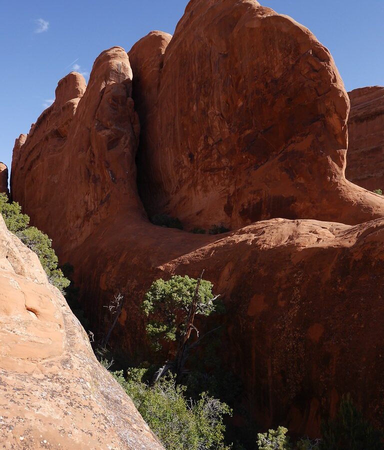
Photo: usareisetipps via Flickr (CC BY-SA 2.0)
The Best Scenic Drives Around Arches National Park connect a compact national park road with Colorado River canyons, sandstone towers, ancient rock art, and high desert plateaus. Arches Scenic Drive runs about 18 miles from the entrance area to Devils Garden, but side roads to The Windows, Delicate Arch, and Wolfe Ranch turn a simple out and back into roughly half a day of driving and short walks.
Outside the park, Utah Highway 128 and Potash Road follow opposite sides of the Colorado River through landscapes shaped by the same uplift, faulting, and erosion. Our team uses these routes to spread sightseeing across different times of day: Arches for elevated overlooks and concentrated formations, Highway 128 for river level canyon walls, and Potash Road for petroglyphs, climbing cliffs, and trail access.
How the Best Scenic Drives Around Arches National Park Fit Together
Distances, surfaces, and realistic driving times
All three primary routes begin close to Moab, yet they deliver very different views. Arches Scenic Drive climbs from about 4,100 feet near the entrance to elevations above 5,000 feet around Devils Garden. Highway 128 stays near the Colorado River before entering broader Professor Valley, while Potash Road follows the river beneath sheer Wingate sandstone cliffs. The following times allow for ordinary sightseeing stops but not long hikes.
| Drive | Approximate distance | Surface | Useful time allowance |
|---|---|---|---|
| Arches Scenic Drive and major spurs | About 45 to 50 miles round trip | Paved | 4 to 6 hours |
| Utah Highway 128 from Moab to Cisco | About 44 miles one way | Paved | 2 to 3 hours with stops |
| Potash Road, Utah Highway 279 | About 17 miles one way | Paved to the potash facility area | 2 to 4 hours with short walks |
Build the route around light and congestion
Enter Arches early if Park Avenue, Delicate Arch, or Devils Garden is the priority. The entrance road gains roughly 1,000 feet through steep switchbacks, and queues can develop before popular trailheads fill. Timed entry policies, entrance fees, road work, and temporary closures can change, so confirm current details on the official park site before choosing an arrival time.
Keep water, food, sun protection, and a paper map in the vehicle. Mobile service is inconsistent beyond Moab, shade is scarce, and summer temperatures commonly exceed 100 degrees Fahrenheit at lower elevations. A practical driving kit includes:
- At least one gallon of water per person for a full summer day
- A full fuel tank before leaving Moab
- Closed shoes for slickrock and sandy paths
- Binoculars for distant arches and desert bighorn sheep
- A flashlight if sunrise or sunset stops are planned
Best Scenic Drives Around Arches National Park’s Sandstone Core
Park Avenue and the Courthouse Towers
Park Avenue is the first major overlook after the entrance climb. The viewpoint looks into a corridor bordered by monoliths including The Organ, Tower of Babel, and Courthouse Towers. These walls belong largely to the Entrada Sandstone, deposited as dunes and sandy flats roughly 150 million years ago. A one mile trail descends through the corridor, but drivers can see the principal formations from the overlook and lower Courthouse Towers pullouts.
Stand at the Park Avenue railing in early morning and the scale becomes clearer than it appears through a windshield. Sand and grit shift underfoot, ravens call against the walls, and cool air lingers in the shadowed corridor while sunlight reaches the upper fins. The cliff faces rise almost vertically, so the view opens downward and forward rather than across a broad horizon.
Balanced Rock, The Windows, and Delicate Arch Road
The Windows spur
Balanced Rock stands beside the main road, with a 128 foot formation supporting a cap of harder Slick Rock Member sandstone above softer Dewey Bridge beds. Just beyond it, a paved spur reaches The Windows section. North Window, South Window, Turret Arch, and Double Arch occupy a dense cluster of fins, making this the most efficient stop for visitors with limited walking time. The Windows loop covers about one mile, while Double Arch requires a much shorter approach.
Wolfe Ranch and the Delicate Arch viewpoints
Delicate Arch Road crosses open desert toward Wolfe Ranch, a small homestead associated with John Wesley Wolfe, who settled here in the late 1800s. The Delicate Arch Trail begins nearby and climbs three miles round trip over exposed slickrock. Drivers skipping the hike can continue to Lower Delicate Arch Viewpoint or walk roughly half a mile uphill to the upper viewpoint, where the arch appears across a sandstone canyon.
Devils Garden at the road’s northern end
The final miles pass Salt Valley, Fiery Furnace, and Skyline Arch before reaching Devils Garden. Salt Valley follows a collapsed anticline created as buried salt beds shifted under the weight of overlying rock. Devils Garden contains long, narrow fins that erosion is gradually separating into arches and isolated pillars. An easy 1.8 mile round trip reaches Landscape Arch, whose opening spans more than 290 feet beneath an exceptionally thin ribbon of sandstone.
Highway 128: One of the Best Scenic Drives Around Arches
From Moab to the canyon narrows
Utah Highway 128 begins near the Colorado River bridge north of central Moab and immediately enters a corridor beneath cliffs of Wingate sandstone. Pullouts reveal cottonwood groves, river bends, and talus slopes below dark desert varnish. Morning light works well on many west facing walls near town, while late afternoon illuminates formations farther east. Watch carefully for cyclists, river access traffic, and wildlife stepping from roadside vegetation.
The canyon exposes several chapters of Colorado Plateau geology. Resistant Wingate sandstone forms the tallest vertical cliffs, the Kayenta Formation creates ledges, and softer Chinle layers appear lower in the sequence. The river has cut downward as the plateau rose, leaving a deep canyon rather than diverting around the uplifted terrain.
Fisher Towers and Professor Valley
About 21 miles from Moab, a signed gravel spur reaches Fisher Towers, a group of red mudstone pinnacles capped and reinforced by harder sandstone. The 4.4 mile round trip Fisher Towers Trail threads beneath formations including The Titan, one of the tallest freestanding towers in the United States. Even without hiking the full route, the access road and trailhead area provide close views of the fluted towers.
East of Fisher Towers, the canyon widens into Professor Valley, where irrigated fields and cottonwoods contrast with the red walls. Castle Rock rises prominently above the valley, backed by the snow holding La Sal Mountains, whose highest summit, Mount Peale, reaches 12,721 feet. This combination of river, ranchland, desert towers, and alpine peaks gives Highway 128 the broadest range of scenery among the paved routes around Arches.
Potash Road: A Top Scenic Drive Around Arches National Park
Rock art, dinosaur tracks, and Wall Street
Potash Road follows Utah Highway 279 west from its junction with U.S. Highway 191. The road squeezes between the Colorado River and tall cliffs used by climbers at Wall Street. Several roadside panels preserve petroglyphs attributed largely to the ancestral Fremont and Ute peoples, including human figures, bighorn sheep, and abstract forms. View them from established pullouts, avoid touching the rock, and never add chalk or markings.
Near the Poison Spider trailhead, a short climb leads toward dinosaur tracks preserved in tilted sandstone. The tracks and petroglyphs are exposed to weathering and can be difficult to distinguish in flat midday light. Low angled morning or afternoon sun brings shallow impressions and pecked designs into sharper relief.
Corona Arch from the river corridor
Farther west, the Corona Arch Trail crosses railroad tracks and open slickrock to reach Corona Arch and neighboring Bowtie Arch. The route is about three miles round trip and includes cables and a short ladder on steeper sections. Corona Arch has an opening roughly 140 feet across and 105 feet high, yet it sits outside Arches National Park, so visitors often overlook it when planning their driving day.
Explore the Best Scenic Drives Around Arches on the La Sal Mountain Loop
The La Sal Mountain Loop adds elevation, forest, and long views across the Colorado Plateau. The paved scenic backway forms a loop of roughly 60 miles through Spanish Valley, the Manti-La Sal National Forest, and Castle Valley. Allow three to four hours from Moab because the road is narrow in places and overlooks invite frequent stops.
From red rock basins to alpine forest
The route climbs above 8,000 feet through pinyon and juniper woodland before entering stands of ponderosa pine, aspen, and Douglas fir. Open slopes provide views toward Behind the Rocks, Canyonlands National Park, and the Book Cliffs. The descent toward Castle Valley frames Castleton Tower and The Rectory from above, a perspective unavailable from Highway 128 at river level.
Temperature and seasonal differences
Elevation can lower afternoon temperatures by 15 to 25 degrees Fahrenheit compared with Moab. Snow may linger near the higher sections after desert roads have dried, and thunderstorms build quickly over the mountains during summer. Use lower gears on prolonged descents, watch for livestock, and leave room for vehicles approaching around blind curves.
| Season | Typical advantage | Main concern |
|---|---|---|
| Spring | Clear desert views and mild valley temperatures | Snow or mud at higher elevations |
| Summer | Cooler mountain air and full road access | Afternoon lightning and intense sun below |
| Autumn | Aspen color and crisp visibility | Early snow following cold fronts |
| Winter | Snow covered peaks above red cliffs | Ice, closures, and limited turnaround space |
Where the Pavement Ends
Several famous backcountry roads connect the Potash corridor with higher terrain, but they require a different vehicle and mindset from the paved drives. Rock ledges, deep sand, exposed switchbacks, and clay that becomes extremely slick when wet can turn a sightseeing detour into a recovery problem. Carry extra water, a full size spare tire, and an offline topographic map.
Potash Road to Shafer Trail
Beyond the paved portion of Highway 279, the route continues past evaporation ponds and enters Canyonlands National Park. The unpaved road eventually meets Shafer Trail, whose tight switchbacks climb roughly 1,400 feet to the Island in the Sky mesa. A high clearance four wheel drive vehicle is appropriate. Drivers uncomfortable reversing near exposed edges should use the paved route to Island in the Sky instead.
Long Canyon and Pucker Pass
Long Canyon Road connects the Potash corridor with Utah Highway 313 through a steep sandstone canyon. Its best known obstacle passes beneath a large fallen slab near Pucker Pass. Surface conditions vary sharply after storms, and clearance matters more than the route’s modest mileage suggests. Avoid the road during rain because runoff concentrates in the canyon and wet clay offers little traction.
Match the Drive to the Time Available
The Best Scenic Drives Around Moab work most efficiently when each day stays within one geographic corridor. Combining Devils Garden, Fisher Towers, and the La Sal loop creates excessive backtracking. Grouping nearby stops preserves useful morning and evening light while leaving enough time for short trails.
A practical one day sequence
- Enter Arches near sunrise and drive directly to Devils Garden.
- Work south through Skyline Arch, the Delicate Arch viewpoints, and The Windows.
- Leave the park during the hottest part of the afternoon for food and water in Moab.
- Finish on Highway 128, where lower evening light reaches Castle Valley and Professor Valley.
How to use a second day
Begin the second morning on Potash Road for rock art, dinosaur tracks, and the Corona Arch trail. After returning to Moab, drive the La Sal Mountain Loop if the high road is clear. This pairing moves from river level to cool mountain forest and ends with elevated views across the same sandstone country explored the previous day.
Choose a Route That Fits Your Vehicle and Schedule
Arches Scenic Drive delivers the greatest concentration of arches and fins on ordinary pavement. Highway 128 supplies the strongest river canyon scenery, while Potash Road combines cultural sites, climbing walls, and access to Corona Arch. The La Sal Mountain Loop adds the widest regional perspective and welcome relief from summer heat.
Most visitors should keep the unpaved Shafer and Long Canyon routes separate from a standard scenic driving plan. With realistic time allowances, adequate water, and an early start, these corridors reveal how the Colorado River, shifting salt beds, resistant sandstone, and mountain uplift shaped the landscape around Arches National Park.
Want to keep exploring? Browse all our Arches guides and articles for more trip-planning tips and ideas.
Gear & Essentials
Tell us about your trip and we will add what else you will want:
The basics
Worth having in the car whatever the park.
For this trip
Traveling with kids
Bringing a pet
RVing
Backcountry
Winter conditions
On the water
Photography
Accessibility
As an Amazon Associate we earn from qualifying purchases, at no extra cost to you.