7 Best Summer Hikes in Pinnacles National Park
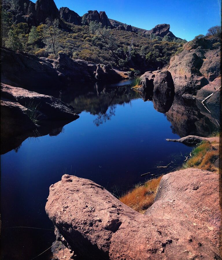
Photo: JingKe888 via Flickr (CC BY 2.0)
Our guide to the Best Summer Hikes Pinnacles has to offer starts with one essential fact: daytime temperatures commonly climb above 90°F, while many routes cross exposed volcanic slopes with little shade. Summer hiking can still be rewarding when you choose the right trail, enter from the correct side of the park, and finish demanding climbs before the hottest part of the day.
The seven routes covered in this guide range from the roughly 2.2 mile Moses Spring and Rim Trail loop to the strenuous climb toward North Chalone Peak, the park’s highest point at 3,304 feet. Together they reach talus caves, High Peaks rock formations, California condor habitat, and quieter wilderness terrain. Our team explains how summer changes each experience, including heat exposure, crowds, cave access, and trailhead logistics.
What Defines the Best Summer Hikes in Pinnacles National Park
Pinnacles National Park protects the eroded remains of an ancient volcanic field associated with formations that originated near present day Lancaster, California. Movement along the San Andreas Fault carried these rocks roughly 195 miles northwest. Erosion subsequently carved the breccia, cliffs, monoliths, and narrow ravines that shape routes such as Condor Gulch, High Peaks, Balconies Cliffs, and Moses Spring.
Heat, elevation, and limited shade
Most hiking takes place between approximately 800 and 3,300 feet, too low for dependable alpine cooling. Chaparral plants such as chamise, manzanita, buckwheat, and gray pine cover the slopes, but they provide limited overhead shade. South and west facing terrain heats quickly after sunrise. Bear Gulch and sections near the talus caves feel cooler, while High Peaks, Juniper Canyon, and Chalone Peak remain exposed for long stretches.
Summer hikers should begin around sunrise and treat noon as a practical turnaround deadline on longer routes. Carry more water than you would for a shaded coastal hike, add electrolytes for sustained climbs, and avoid relying on finding drinking water along the trail. A wide brimmed hat, sunscreen, and a headlamp for cave routes belong in every summer pack.
Wildlife around the High Peaks
Pinnacles is one of the most reliable places in central California to look for California condors. These birds often ride morning thermals around Scout Peak and the High Peaks, where their wingspans can approach 9.5 feet. Turkey vultures are more common and can be distinguished by their smaller size, silvery flight feathers, and frequent rocking motion. Prairie falcons, golden eagles, and peregrine falcons also use the cliffs, and temporary wildlife closures can protect active nesting areas.
On the High Peaks Trail, rough stone and metal handrails lead across ledges cut into tawny volcanic rock. The air is often still near the lower switchbacks, then noticeably cooler where the path reaches an exposed saddle. Boots scrape against angular breccia, ravens call across the gullies, and the view opens abruptly toward the Gabilan Range. The narrow tread and steep drop offs make this section feel more committing than its mileage suggests.
How Summer Compares With Other Hiking Seasons
Summer provides long daylight, generally dry trails, and dependable road access, but it is the least forgiving season for an unplanned midday hike. Spring has cooler temperatures and wildflowers, while autumn gradually improves as daytime heat retreats. Winter brings green hills and comfortable climbing weather, although rain can make cave passages wet and affect unpaved or low lying trail sections.
| Season | Typical conditions | Crowd pattern | Trail and cave considerations | Best use |
|---|---|---|---|---|
| Spring | Mild to warm days, wildflowers, occasional rain | Heaviest on pleasant weekends | Nesting closures and changing cave conditions are possible | High Peaks climbs and flower walks |
| Summer | Hot, dry, and exposed, with cooler mornings | Busy early, quieter during dangerous afternoon heat | Bat protection can affect Bear Gulch Cave access | Sunrise hikes and short cave approaches |
| Autumn | Hot early in the season, milder later | Moderate, with weekend peaks | Dry trails are common before winter rain | Longer loops after temperatures fall |
| Winter | Cool, greener, and occasionally wet | Generally lower outside holidays | Rain can create slick rock and wet cave passages | Strenuous exposed routes |
How Crowds Affect the Best Summer Hikes Pinnacles Routes
Crowds affect parking and trail pace more than backcountry solitude. On the east side, vehicles can fill the closest parking areas on weekends, potentially adding walking or internal transportation logistics before the hike begins. Inside Bear Gulch Cave, two way traffic slows at narrow stairways and boulder squeezes. On the Steep and Narrow section of High Peaks Trail, hikers may need to wait at handrails where safe passing space is limited.
Caves are seasonal wildlife habitat
Bear Gulch and Balconies are talus caves, formed where enormous boulders fell into narrow ravines and created passages beneath them. They are not limestone caverns with extensive mineral formations. Bear Gulch Cave shelters a maternity colony of Townsend’s big eared bats, so portions can close during sensitive periods. Balconies Cave may require scrambling through dark, uneven openings even when conditions are dry.
Planning Trail Access for the 7 Best Summer Hikes in Pinnacles National Park
Pinnacles has separate east and west entrances with no connecting road through the park. Driving between them requires leaving the park and circling through surrounding roads, commonly taking roughly 90 minutes or longer. Selecting the wrong entrance can therefore eliminate the planned hike. The east side serves Bear Gulch, Condor Gulch, Moses Spring, and Chalone Peak routes. The west side provides direct access to Balconies Cliffs and Juniper Canyon.
Choose the entrance before choosing a trailhead
The east entrance, approached from the Hollister and San Juan Bautista direction, generally provides access to the largest concentration of trail connections. It is the practical choice for Bear Gulch Reservoir and the Condor Gulch approach to High Peaks. The west entrance, reached through the Soledad area, places hikers closer to Chaparral and the dramatic walls around Balconies. Roads near both entrances are narrow, so additional travel time matters before a sunrise start.
Fees, parking, and cave status
Entrance fees, campground reservations, operating hours, internal transportation, and cave openings can change. Check all of these on the official park site before departure, especially if the itinerary depends on entering Bear Gulch Cave or securing an early parking space. Camping is associated with the east side, which makes it useful for starting Condor Gulch or Chalone Peak before day visitors arrive.
A summer start time framework
Our team sorts the seven hikes into three timing categories. Short cave and reservoir walks can work in the early morning, moderate loops should begin by sunrise, and strenuous summit routes require both an early start and a conservative heat forecast. Turn around if water consumption is faster than planned, since exposed return trails can be hotter than the initial climb.
- Short outings: Moses Spring and Rim Trail or the Balconies Cave and Cliffs area, provided cave access and temperatures are suitable.
- Moderate objectives: Condor Gulch viewpoints, Bear Gulch Reservoir, or Juniper Canyon routes with meaningful climbing.
- Strenuous days: High Peaks loops and North Chalone Peak, where elevation gain, exposure, and afternoon heat compound one another.
- Heat fallback: Replace a summit attempt with a shorter shaded approach, then leave exposed terrain before midday.
Match the Route to the Coolest Part of the Day
The seven hikes differ sharply in exposure, climbing, and escape options. Balconies Cave and Moses Spring allow an early turnaround if temperatures rise faster than expected. North Chalone Peak and the longer High Peaks circuits commit hikers to several exposed miles before returning to lower terrain. Approximate figures below can vary slightly with parking location and cave detours.
| Route | Approximate distance | Elevation gain | Best summer window |
|---|---|---|---|
| Condor Gulch Overlook | 2 miles round trip | 530 feet | Sunrise to midmorning |
| Moses Spring and Rim Trail | 2.2 mile loop | 500 feet | Early morning |
| Balconies Cliffs and Cave | 2.4 mile loop | About 100 feet | Early morning |
| Juniper Canyon Loop | 4.3 miles | About 1,200 feet | At sunrise |
| High Peaks and Bear Gulch Loop | 6.7 miles | About 1,425 feet | Before sunrise or at first light |
| Balconies and High Peaks Loop | 8.4 miles | About 1,540 feet | Cool forecast and first light |
| North Chalone Peak | About 9 miles round trip | About 2,040 feet | Coolest summer mornings only |
Short hikes with flexible turnarounds
Condor Gulch Overlook is the most direct choice for broad views without entering the Steep and Narrow section. Moses Spring reaches shaded rock corridors and Bear Gulch Reservoir, while the Balconies loop combines cliffs with a darker talus passage. These routes suit families and first-time visitors, but cave stairs, loose stones, and low boulders still require stable footwear.
Long routes that demand conservative timing
The Best Summer Hikes Pinnacles list becomes more serious above four miles. Juniper Canyon gains elevation rapidly from the west, and both High Peaks loops spend substantial time on sunlit slopes. North Chalone Peak adds a sustained climb beyond the reservoir area toward an old fire lookout site. Save these routes for mornings with moderate forecasts rather than treating an early start as complete protection from heat.
Reservations, Permits, and Seasonal Access
Pinnacles does not generally require an individual wilderness permit for ordinary day hikes, and there is no trail quota comparable to those used for some Sierra Nevada routes. Parking capacity creates the practical limit. A campground reservation provides an overnight base on the east side, but visitors should not assume it changes trail conditions, cave closures, or access to sensitive wildlife areas.
Plan overnight stays before summer weekends
The park campground can reduce predawn driving for Bear Gulch and Condor Gulch departures. Summer daytime heat makes campsite shade and nighttime temperatures important considerations, particularly for tents. Reservation inventory, site rules, and booking windows can change, so use the logistics information already noted above before committing to a nonrefundable itinerary.
Understand what a closure changes
A cave closure rarely closes the entire surrounding trail network. At Bear Gulch, hikers can usually use an aboveground alignment to continue toward the reservoir when cave passages are unavailable. A nesting closure may affect a specific climbing formation or trail segment. Read posted maps carefully because the safe alternative might require additional mileage, elevation gain, or a return to the original junction.
A Decision Framework for Choosing Your Hike
Choose according to the least heat-tolerant person in the group, not the strongest hiker’s preferred mileage. Children, older adults, visitors arriving from cool coastal climates, and anyone unaccustomed to dry heat may need a shorter objective. High temperatures also reduce the margin for managing blisters, navigation mistakes, or a delayed turnaround.
Choose by priority
- For condor viewing: Select Condor Gulch or a High Peaks route and scan above ridgelines during developing morning thermals.
- For caves: Choose Moses Spring or Balconies, carry a headlamp, and expect uneven rock rather than a level walkway.
- For a summit: Attempt North Chalone Peak only with sufficient water, an early departure, and a cool forecast.
- For limited time: Use Condor Gulch Overlook or the Balconies loop instead of compressing a longer circuit into midday.
Use objective turnaround signals
Turn back for headache, nausea, unusual irritability, dizziness, or declining coordination. These can indicate heat illness rather than ordinary fatigue. Water remaining should cover the full return, with a reserve for delays. If the group reaches exposed high terrain later than planned, shortening the route is safer than trying to recover time by moving faster in rising heat.
Build a Summer Day That Leaves Room for Change
A successful Pinnacles plan pairs one primary route with a shorter alternative from the same entrance. East-side hikers can replace North Chalone Peak with Moses Spring or Condor Gulch. West-side hikers can exchange a High Peaks circuit for Balconies Cliffs and Cave. This preserves the trip when heat, parking, wildlife protection, or group energy changes the original objective.
The seven routes cover caves, reservoirs, volcanic ridges, condor habitat, and the park’s highest summit, but they do not carry equal summer risk. Match distance and exposure to the forecast, enter through the correct side, start during the coolest hours, and keep the turnaround flexible. Those decisions make the difference between enduring the heat and having enough time to observe the landscape safely.
Want to keep exploring? Browse all our Pinnacles guides and articles for more trip-planning tips and ideas.
Gear & Essentials
Tell us about your trip and we will add what else you will want:
The basics
Worth having in the car whatever the park.
For this trip
Traveling with kids
Bringing a pet
RVing
Backcountry
On the water
Photography
Accessibility
As an Amazon Associate we earn from qualifying purchases, at no extra cost to you.