Sequoia National Park: The Perfect 3-Day Itinerary
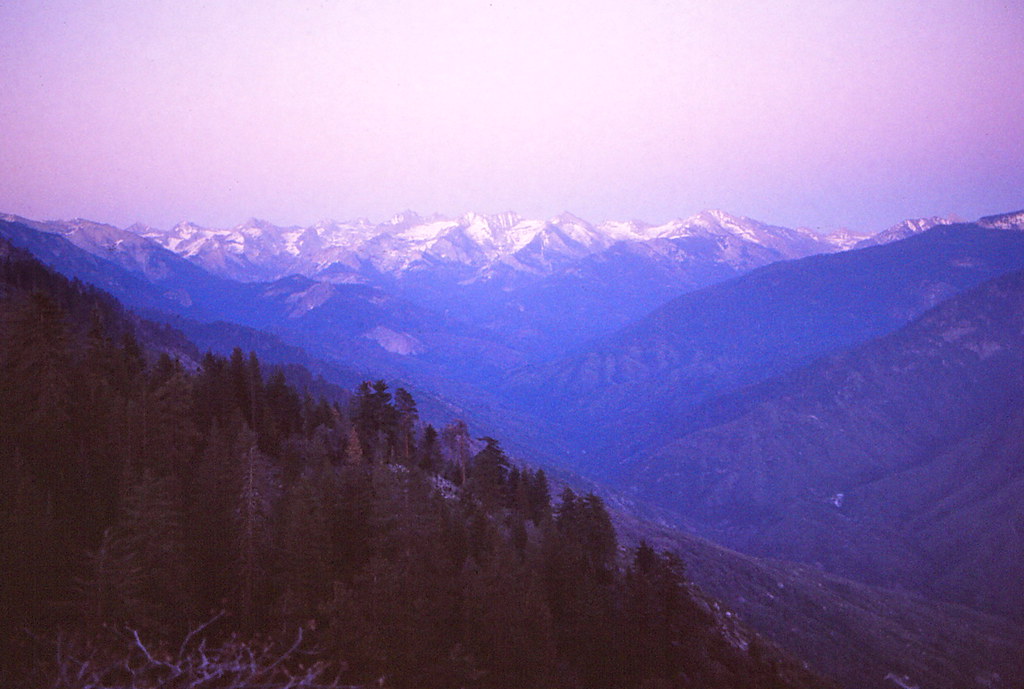
Photo: Ladycliff via Flickr (CC BY 2.0)
Sequoia National Park: The Perfect 3-Day Itinerary works best when you enter through the southern foothills, spend two nights near the Giant Forest or Lodgepole, and leave through the park’s northern entrance. This south to north route follows the Generals Highway, limits backtracking, and reveals the park’s remarkable elevation range in sequence, from oak woodland near 1,700 feet to giant sequoia groves above 6,000 feet.
Three days provide enough time for the General Sherman Tree, Congress Trail, Moro Rock, Crescent Meadow, and a longer mountain walk without forcing several major hikes into one day. Our plan assumes three usable sightseeing days and two nights inside the park or in the surrounding national forest. Travelers staying in Three Rivers should allow considerably more driving because the steep road to Giant Forest can take 75 to 90 minutes each way.
Sequoia National Park: The Perfect 3-Day Itinerary at a Glance
The route begins at the Ash Mountain Entrance on California Highway 198, climbs through the Foothills and Giant Forest, and eventually continues north toward the Big Stump Entrance on Highway 180. It works especially well for travelers approaching from Visalia or Three Rivers. Visitors arriving from Fresno can reverse the order, although descending the narrow southern Generals Highway requires careful braking and extra attention around blind curves.
How the Perfect 3-Day Sequoia National Park Itinerary Fits Together
Day one covers the largest elevation change and introduces the park’s ecological zones. Day two concentrates on the Giant Forest, where short distances conceal a full day of walking among mature sequoias. Day three, covered in the second half of our itinerary, uses the Lodgepole area for a longer hike before continuing north. Drive times below exclude sightseeing stops, road construction, wildlife delays, and time spent finding parking.
| Day | Main stops | Primary highlight | Approximate park driving |
|---|---|---|---|
| 1 | Ash Mountain, Hospital Rock, Giant Forest, Moro Rock | Foothills to high country transition | 2 hours |
| 2 | General Sherman Tree, Congress Trail, Crescent Meadow | Largest sequoia groves | 30 to 60 minutes |
| 3 | Lodgepole, Tokopah Valley, northern Generals Highway | Granite canyon hike and northward exit | About 1 hour |
Must see stops and optional additions
Treat the General Sherman Tree, Congress Trail, and Giant Forest Museum area as priorities. Moro Rock is also essential when its access road and staircase are open, but ice, thunderstorms, smoke, or limited parking can make it impractical. Hospital Rock, Beetle Rock, and the Big Trees Trail are useful additions because each requires relatively little time. Mineral King is excluded because its long, winding access road demands a separate day and operates seasonally.
Planning the Perfect Sequoia National Park Route
The Generals Highway determines the pace of this trip. Between Ash Mountain and Giant Forest, it climbs roughly 5,000 feet through sharp switchbacks, narrow sections, and exposed slopes. Large RVs and trailers face vehicle length advisories on portions of this road. Drivers with oversized vehicles should study the park’s published restrictions and consider entering from Highway 180, where the approach is less severe.
Fuel, food, and mobile service
Fuel is generally unavailable within Sequoia National Park, so fill the tank in Three Rivers, Visalia, or the Fresno area before entering. Food choices inside the park are limited and seasonal. Carry breakfast supplies, trail lunches, and enough water for the day rather than building the schedule around a restaurant. Mobile reception is unreliable in the Giant Forest, Lodgepole, and the canyons below the Generals Highway, so download maps and reservation details before arrival.
- Start with a full fuel tank and avoid letting it fall below half.
- Download an offline road map and the official park map.
- Pack food in wildlife resistant storage and never leave it visible in an unattended vehicle.
- Carry layers because temperatures can differ sharply between the foothills and sequoia groves.
- Bring traction devices when snow or overnight ice is possible.
Where to sleep for two nights
A single base near Giant Forest, Lodgepole, or Wuksachi keeps the itinerary efficient. These areas sit close to the main sequoia groves and eliminate repeated climbs from Three Rivers. Campgrounds and park lodging can fill well in advance, particularly from late spring through early autumn. Current fees, reservations, road openings, shuttle operations, food service, and campground facilities should be confirmed on the official park site before travel.
Why changing lodging wastes time
Moving after the first night adds packing, checkout, parking, and check-in time without improving access to the central sights. Giant Forest and Lodgepole are only a few miles apart, while Crescent Meadow and the General Sherman area are connected by short roads and seasonal transportation. Keep both nights in one place unless the third day includes an early departure toward Kings Canyon National Park or Fresno.
Day 1 of Sequoia National Park: The Perfect 3-Day Itinerary
Enter through Ash Mountain early enough to allow at least six hours before sunset. The road begins in the Kaweah River drainage, where blue oak, gray pine, chaparral, and exposed metamorphic rock reflect the hot, dry foothill climate. Black bears occur throughout this elevation range, and mule deer frequently cross near developed areas. Drive slowly, especially around dawn and dusk.
Hospital Rock and the climb into Giant Forest
Hospital Rock provides a useful first stop roughly six miles beyond the entrance. Native American pictographs and nearby bedrock mortars document the long Indigenous use of the Middle Fork Kaweah corridor. From here, the highway begins its sustained climb toward Giant Forest. Use lower gears rather than riding the brakes, and stop only at established pullouts because shoulders are narrow.
As elevation increases, oak woodland gives way to ponderosa pine, incense cedar, white fir, and eventually giant sequoias. The change can also produce a temperature drop of 15 to 25 degrees Fahrenheit. Snow may linger in the grove long after spring has reached Three Rivers, while summer afternoons can bring thunderstorms over the Sierra crest.
Moro Rock and the first sequoia walk
When conditions permit, make Moro Rock the afternoon objective. The granite dome rises to 6,725 feet, and a stone staircase of roughly 350 steps reaches the summit. The climb is short but exposed, with steep drop-offs and little shelter from lightning. Anyone uncomfortable with heights can substitute Beetle Rock, which provides a gentler westward view near the Giant Forest Museum.
What the summit feels like
Near the top, the staircase narrows between rough granite walls before opening onto an exposed ridge. Cool wind moves across the rock even when the foothills below feel hot, and the Kaweah River canyon drops abruptly beyond the railing. To the east, layers of pale Sierra granite rise toward the Great Western Divide. Footsteps, wind, and occasional raven calls replace the traffic noise heard lower on the road.
Finish beside Round Meadow
Use the remaining daylight for the Big Trees Trail, a mostly level loop of approximately 1.2 miles around Round Meadow. Interpretive displays explain how shallow sequoia roots, periodic fire, and openings in the forest canopy support regeneration. Young sequoias require mineral soil and abundant sunlight, conditions historically created by frequent low intensity fires. After the walk, return to the same central lodging or campground for the first night.
Day 2: The General Sherman Tree and Giant Forest
Begin at the General Sherman Tree before the busiest part of the day. The main trail descends about half a mile through the grove and loses roughly 200 feet, which becomes an uphill return. General Sherman stands approximately 275 feet tall and contains more trunk volume than any other known living single stem tree. Its broad top reflects centuries of lightning damage, while the surviving crown continues adding wood each year.
Walk beyond the busiest viewpoint
Continue onto the Congress Trail rather than turning around after the Sherman viewing area. This paved loop adds roughly two miles and passes named clusters including the Senate and the House. It also reveals the grove’s mixed composition, with enormous sequoias rising among white fir, sugar pine, and incense cedar. Allow two hours for the combined route, longer if snow, photography, or frequent stops slow your pace.
Crescent Meadow and Tharp’s Log
Spend the afternoon on the Crescent Meadow loop, approximately 1.8 miles before optional extensions. The route follows a bright wet meadow bordered by mature sequoias and reaches Tharp’s Log, a fallen tree that cattleman Hale Tharp used as a seasonal cabin in the nineteenth century. Add the spur toward Log Meadow if you have energy, then return to the same lodging for the second night. Bears sometimes forage near these meadows, so maintain distance and keep food secured.
Day 3: Tokopah Valley and the Northern Exit
Day three shifts from sequoia groves to a granite valley carved by the Marble Fork of the Kaweah River. Start from the Lodgepole area and allow three to four hours for the Tokopah Falls Trail. The approximately four mile round trip gains about 600 feet, following the river beneath the steep walls of Tokopah Valley. Early starts provide cooler temperatures and leave enough time for the drive north.
Choosing the right morning hike
Tokopah Falls is strongest during spring snowmelt, when water descends about 1,200 feet through a long sequence of granite cascades. By late summer, flow can shrink substantially, but the canyon remains worthwhile for its polished boulders, lodgepole forest, and views toward the Watchtower. The final section crosses exposed rock and receives little shade. Turn around at any comfortable point if heat, ice, or approaching thunderstorms make the upper canyon unsafe.
Follow the Generals Highway north
After the hike, continue toward the Big Stump Entrance rather than retracing the southern switchbacks. Allow time for overlooks and roadside sequoias, but keep the final schedule flexible because the highway is winding. Travelers continuing into Kings Canyon can add Grant Grove, while those bound for Fresno should proceed west on Highway 180. A practical departure sequence is:
- Eat lunch and refill water near the Lodgepole area.
- Drive north without adding another long trail.
- Stop at one or two signed overlooks if daylight permits.
- Exit toward Highway 180 before fatigue makes the mountain drive harder.
Adjusting the Route for Weather and Snow
What makes a Sequoia National Park Perfect itinerary in June can be unrealistic in January. Elevation controls access: rain in Three Rivers may fall as heavy snow around Giant Forest, and shaded trails can retain ice after roads have cleared. Summer brings easier access but also hotter foothills, crowded parking areas, wildfire smoke, and afternoon thunderstorms. Autumn usually offers cooler hiking conditions, although early storms can close minor roads with little warning.
Season by season priorities
| Season | Likely conditions | Best adjustment |
|---|---|---|
| Spring | Snow in groves, strong waterfalls, variable road conditions | Carry traction and allow extra hiking time |
| Summer | Open high country, warm afternoons, heavier visitation | Start major walks before midmorning |
| Autumn | Cool mornings, shorter daylight, possible early snow | Finish remote stops well before sunset |
| Winter | Snowpack, chain controls, closed side roads | Base plans on accessible groves and short snow walks |
Winter substitutions
When the Moro Rock and Crescent Meadow road is closed, replace those stops with additional time around Giant Forest, the Sherman Tree area, or designated snow routes. Snowshoes may be useful after fresh accumulation, while traction devices work better on compacted, icy paths. Winter daylight is limited, so avoid pairing a late grove walk with a long descent to Three Rivers. Carry food, warm layers, gloves, and a headlamp even for a short outing.
Completing Your Perfect 3-Day Sequoia National Park Journey
This route succeeds because each day has a distinct purpose. Day one follows the dramatic ecological climb from the Kaweah foothills to Moro Rock and Round Meadow. Day two concentrates on the largest trees without unnecessary driving. Day three adds a granite river canyon, then uses the northern exit to avoid backtracking. Keeping both nights near the central groves protects valuable morning and evening hours.
Leave room for changing mountain conditions rather than treating every optional stop as mandatory. Prioritize General Sherman, Congress Trail, Crescent Meadow, and one landscape hike suited to the season. With fuel purchased beforehand, offline navigation ready, and lodging in a central location, three days provide enough time to understand how elevation, fire, water, and granite have shaped Sequoia National Park.
Want to keep exploring? Browse all our Sequoia guides and articles for more trip-planning tips and ideas.
Gear & Essentials
Tell us about your trip and we will add what else you will want:
The basics
Worth having in the car whatever the park.
For this trip
Traveling with kids
Bringing a pet
RVing
Backcountry
Winter conditions
On the water
Photography
Accessibility
As an Amazon Associate we earn from qualifying purchases, at no extra cost to you.