10 Best Hikes in Yosemite National Park
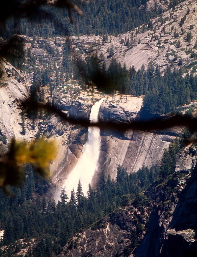
Photo: Ladycliff via Flickr (CC BY 2.0)
Our guide to the 10 best hikes Yosemite has to offer begins with a useful contradiction: several of the park’s greatest trails start beside crowded roads, then reach remarkably wild terrain within a few miles. Yosemite Valley sits at roughly 4,000 feet, while its surrounding walls rise another 3,000 feet. Choosing a trail by mileage alone can therefore produce a much harder day than expected.
The ten routes below cover Yosemite Valley, Glacier Point, the sequoia groves, and the higher Tioga Road corridor. Together they reveal the park’s defining features: granite domes shaped by exfoliation, cliffs carved by glaciers, waterfalls fed by Sierra snowpack, and subalpine basins above 8,000 feet. This first half concentrates on orientation and the five essential hikes beginning in Yosemite Valley.
How the 10 Best Hikes in Yosemite National Park Compare
Yosemite’s trail network ranges from level paths beneath black oaks to exposed climbs gaining several thousand feet. Waterfall hikes are generally strongest during spring snowmelt, while high-country routes often remain snowbound into early summer. By late summer, Yosemite Falls can shrink dramatically, but Tioga Road trails usually offer clearer footing and cooler temperatures.
Distances, elevation gain, and primary landscapes
Distances below are approximate round-trip figures unless identified as one-way. Elevation gain matters as much as mileage here because several Valley trails climb steeply without extended recovery sections. The Panorama Trail is commonly walked one-way from Glacier Point, while the longer Valley Loop can be shortened using bridges and cross-Valley paths.
| Hike | Distance | Approximate gain | Best-known feature |
|---|---|---|---|
| Mist Trail to Nevada Fall | 5.4 miles | 2,000 feet | Vernal and Nevada falls |
| Upper Yosemite Fall | 7.2 miles | 2,700 feet | Top of Yosemite Falls |
| Four Mile Trail | 9.6 miles | 3,200 feet | Glacier Point views |
| Mirror Lake Loop | About 5 miles | Minimal | Tenaya Canyon |
| Valley Loop Trail | 11.5 miles | Mostly level | Meadows and cliff bases |
| Sentinel Dome and Taft Point Loop | About 5 miles | About 1,000 feet | Granite dome and fissures |
| Panorama Trail | About 8.5 miles one-way | Primarily descending | Illilouette Fall and Half Dome |
| Cathedral Lakes | 7 to 8 miles | About 1,000 feet | Subalpine lakes and Cathedral Peak |
| Glen Aulin | About 11 miles | About 800 feet | Tuolumne River cascades |
| Grizzly Giant Loop | About 2 miles | About 300 feet | Giant sequoias |
Choosing Among the 10 Best Hikes Yosemite Visitors Can Attempt
Match the route to current snow, waterfall flow, temperature, and daylight rather than following a fixed ranking. Mist Trail suits hikers comfortable with wet granite steps. Mirror Lake and the Valley Loop provide lower-impact alternatives. Cathedral Lakes and Glen Aulin make better midsummer choices once the Tioga Road corridor and high-country trailheads are accessible.
Plan the 10 Best Hikes in Yosemite Around Elevation and Seasonal Access
Yosemite covers nearly 1,200 square miles, and its trailheads are separated by long mountain roads. Yosemite Valley serves the waterfall routes, Four Mile Trail, Mirror Lake, and the Valley Loop. Glacier Point Road accesses Sentinel Dome and Taft Point. Tioga Road crosses the high country near Tuolumne Meadows, approximately 55 road miles from the Valley, so combining those areas casually in one hiking day is inefficient.
When the waterfall trails are strongest
April through June usually brings the largest waterfall volume, though annual snowpack and spring temperatures control the exact peak. Mist from Vernal Fall can soak the staircase, while shaded portions of Upper Yosemite Fall may retain snow or ice. Summer brings longer daylight and drier footing, but exposed switchbacks become hot. Autumn offers cooler Valley hiking with substantially reduced waterfall flow.
Permits, transport, and trail conditions
Ordinary day hikes generally differ from wilderness overnight trips, which require wilderness permits. Some routes can also be affected by seasonal road closures, temporary trail closures, managed access systems, or transportation changes. Before committing to an itinerary, confirm current entrance requirements, permits, road status, shuttle operations, and trail closures on the official park site.
What our team carries on Valley climbs
- At least two liters of water per person for moderate outings, with additional capacity for exposed all-day climbs.
- Food containing both salt and carbohydrates, especially for routes gaining more than 2,000 feet.
- Footwear with reliable traction for polished granite and wet stone steps.
- A paper trail map because cliffs and canyon walls can interfere with phone service.
- Sun protection, a light insulating layer, and a waterproof shell during spring runoff or unsettled Sierra weather.
Five of the 10 Best Hikes in Yosemite National Park Begin in Yosemite Valley
The Valley’s compact map disguises major differences among its trails. Mirror Lake enters a narrow canyon with little climbing, while Four Mile Trail rises through several vegetation zones to Glacier Point. Starting early reduces heat and congestion, but it also provides more turnaround time if elevation gain, wet footing, or changing weather slows the group.
1. Mist Trail to Vernal Fall and Nevada Fall
The Mist Trail begins near Happy Isles and follows the Merced River toward two major waterfalls. Vernal Fall is reached by a steep granite staircase, with a roughly 2.4-mile round trip to its top. Continuing through forest and exposed switchbacks to 594-foot Nevada Fall creates a 5.4-mile day. The John Muir Trail provides a longer, generally less saturated return option when open.
Beside Vernal Fall, the river’s roar fills the gorge and cold spray hangs over the steps. Granite underfoot feels slick and uneven, especially where thousands of boots have polished the surface. The staircase climbs close enough to the falling water that glasses fog and clothing can become soaked before the rim appears above the trees.
2. Upper Yosemite Fall Trail
This demanding climb starts near Camp 4 and ascends through oak woodland to Columbia Rock, an early viewpoint over the Valley. The route then passes a clear view of Upper Yosemite Fall before tackling tight, exposed switchbacks to the rim. The full hike gains about 2,700 feet, and the upper section receives intense afternoon sun after leaving the shaded lower forest.
3. Four Mile Trail to Glacier Point
Despite its historic name, the modern trail is closer to 4.8 miles each way. It climbs from the south side of Yosemite Valley to Glacier Point, gaining roughly 3,200 feet through forest and open switchbacks. Views expand toward Yosemite Falls, El Capitan, Half Dome, and the Merced River far below. Seasonal closure is common when ice and snow make upper sections unsafe.
4. Mirror Lake and Tenaya Canyon
The shortest option reaches Mirror Lake in roughly one mile from the primary trail area, while the full loop extends for about five miles around Tenaya Creek. The “lake” is a seasonal pool that can shrink into meadow and braided channels later in the year. The route’s value lies in its close perspective beneath Half Dome and Mount Watkins, plus access to Tenaya Canyon’s glacially carved entrance.
5. Valley Loop Trail
The Valley Loop links meadows, woodland, riverbanks, and the bases of major cliffs without a sustained climb. A full circuit covers about 11.5 miles, while bridge crossings make shorter variations possible. The western portion passes beneath El Capitan and near Bridalveil Fall, providing a better sense of the Valley’s scale than roadside viewpoints. Watch for loose talus near cliff bases and seasonal standing water in meadow-adjacent sections.
Glacier Point Road Reaches Two Very Different Granite Walks
The Glacier Point area places hikers above Yosemite Valley without requiring the 3,200-foot climb from the Valley floor. Its trails cross exposed granite, lodgepole pine forest, and shallow soils that dry quickly after snowmelt. Afternoon thunderstorms can develop rapidly along this high rim, so exposed viewpoints are best visited early when summer forecasts show unsettled weather.
6. Sentinel Dome and Taft Point Loop
Sentinel Dome rises to 8,122 feet and provides an unobstructed panorama of Half Dome, El Capitan, Yosemite Falls, and the Clark Range. Linking it with Taft Point creates a roughly five-mile circuit through forest and along the Valley rim. Taft Point’s vertical fissures are deep fractures in the granite, and the cliff edge drops about 3,000 feet. There are no continuous barriers, so children and distracted photographers need close supervision.
7. Panorama Trail
The Panorama Trail descends from Glacier Point toward Illilouette Fall, crosses Illilouette Creek, then climbs before dropping toward Nevada Fall and Happy Isles. That intermediate ascent makes the route harder than its downhill profile suggests. The shifting view of Half Dome is the signature experience, particularly where its rounded shoulder gives way to the sheer northwest face. Arrange transportation before departure because the trailheads are separated by road and substantial elevation.
Tioga Road Opens Yosemite’s Subalpine Country
Trails near Tuolumne Meadows begin around 8,600 feet, where thinner air can slow hikers arriving directly from low elevations. Snowfields, flooded meadows, and high creek levels may persist after the Valley has entered summer. Once dry, this corridor offers cooler walking through lodgepole forest, polished granite slabs, and open basins shaped by repeated Sierra glaciation.
8. Cathedral Lakes
The Cathedral Lakes Trail follows part of the John Muir Trail before climbing toward Lower Cathedral Lake beneath 10,940-foot Cathedral Peak. Most hikers choose either the lower lake, with its broad granite shoreline, or continue to Upper Cathedral Lake near Tresidder Peak. Stay on durable rock and established paths around both lakes because short growing seasons make trampled subalpine vegetation slow to recover.
9. Glen Aulin
Glen Aulin follows the Tuolumne River past granite pools, cascades, and the broad lip of Tuolumne Falls. The outbound route generally loses elevation, leaving a deceptive uphill return at the end of an approximately 11-mile day. Keep away from smooth rock beside fast water. Cold runoff can sweep a person downstream even where the river appears shallow near its margins.
Mariposa Grove Adds a Living Record of Fire and Time
The final selection changes the scale from cliffs to trees. Giant sequoias occur naturally only in scattered groves on the western slope of the Sierra Nevada. Their thick, fibrous bark resists many low-intensity fires, while heat helps release seeds from cones and opens patches of mineral soil where seedlings can establish.
10. Grizzly Giant Loop
This approximately two-mile route passes the Grizzly Giant, one of Yosemite’s largest sequoias, and the California Tunnel Tree, cut in 1895 during an era when drive-through trees were promoted as tourist attractions. The modest mileage works well after a longer hiking day, though the grove stands near 6,000 feet and includes rolling terrain that feels harder than a level woodland stroll.
How to walk responsibly among the sequoias
Remain on constructed trails and boardwalks where provided. Sequoias have wide, relatively shallow root systems, so repeated foot traffic around their trunks compacts soil and reduces water infiltration. Fallen cones, bark, and branches also remain part of the grove’s nutrient cycle and should stay where they land.
Build a Plan for the 10 Best Hikes Yosemite Offers
The 10 Best Hikes Yosemite visitors can choose from become easier to organize when grouped by elevation and road corridor. Avoid scheduling a major Valley climb immediately before Panorama Trail or Glen Aulin. A lower-impact day at Mirror Lake, the sequoia grove, or the Valley Loop gives tired legs time to recover while still covering a distinct Yosemite landscape.
Match each hiking day to conditions
| Conditions | Strong choices | Main concern |
|---|---|---|
| Heavy spring runoff | Mist Trail, Upper Yosemite Fall | Wet stone, spray, and cold water |
| Hot Valley afternoon | Cathedral Lakes, Glen Aulin | Altitude and exposed granite |
| Clear high-country morning | Sentinel Dome, Taft Point | Cliff edges and lightning exposure |
| Reduced waterfall flow | Valley Loop, Grizzly Giant Loop | Heat and limited natural water |
Use turnaround rules instead of a fixed summit goal
Choose a turnaround time before starting and shorten the route if the group falls behind it. Granite becomes dangerous during rain, thunder signals immediate retreat from domes and exposed rims, and dark clouds can hide approaching weather behind cliffs. Carry all drinking water or treat backcountry sources properly, since clear Sierra water can still contain pathogens.
- Turn around when thunder is audible from an exposed dome, rim, or open meadow.
- Never enter swift runoff to recover dropped equipment.
- Store food and scented items according to Yosemite’s bear rules.
- Allow extra time for the uphill return from Glen Aulin.
Choosing Your Yosemite Trail
These ten hikes form a practical cross-section of Yosemite: waterfall staircases in the Valley, rim views above Glacier Point, glacial lakes along Tioga Road, river cascades near Tuolumne Meadows, and ancient sequoias in Mariposa Grove. Selecting among them by season and elevation produces a safer, more varied trip than ranking them by distance alone.
For a first visit, combine one strenuous Valley climb with one high-country or grove hike. Returning hikers can concentrate on Panorama Trail, Glen Aulin, or a full Valley Loop to see how water, granite, fire, and elevation connect the park’s separate corridors. Start early, preserve a firm turnaround time, and leave enough flexibility for Sierra weather to reshape the day.
Want to keep exploring? Browse all our Yosemite guides and articles for more trip-planning tips and ideas.
Gear & Essentials
Tell us about your trip and we will add what else you will want:
The basics
Worth having in the car whatever the park.
For this trip
Traveling with kids
Bringing a pet
RVing
Backcountry
Winter conditions
On the water
Photography
Accessibility
As an Amazon Associate we earn from qualifying purchases, at no extra cost to you.