Crater Lake National Park in Fall: What to Expect and What to Do

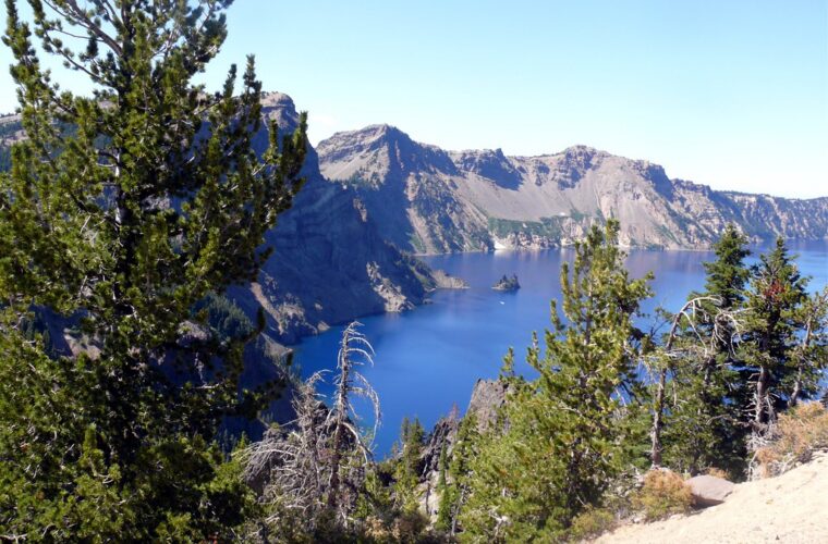
Photo: davidwilson1949 via Flickr (CC BY 2.0)
Crater Lake National Park in fall rewards flexible visitors with thinner crowds, clear air, and early snow around the deepest lake in the United States. September usually provides the best balance of open roads and cool hiking weather. By October, storms can close Rim Drive, trailheads, and the North Entrance with little warning, shifting a driving and hiking trip into a quieter visit focused on Rim Village and the park’s southern approach.
The lake occupies the caldera left when Mount Mazama collapsed about 7,700 years ago. Its surface sits at roughly 6,178 feet above sea level, while surrounding viewpoints rise above 7,000 feet. Those elevations make autumn brief and unpredictable. Conditions at the rim can be cold, foggy, and snowy even when communities along Oregon Route 62 are experiencing rain or sunshine.
Crater Lake National Park in Fall: What to Expect and What to Do
Fall at Crater Lake is a transition between the short summer operating season and one of the snowiest winters in the United States. September often feels like an extension of summer during the afternoon, but freezing nights become increasingly common. October brings a much greater chance of accumulating snow, icy pavement, obscured viewpoints, and seasonal road closures.
September preserves the widest range of options
Early and middle September generally suit travelers who want to circle the caldera, hike from multiple trailheads, and stop at overlooks such as Watchman Overlook, Cloudcap Overlook, and Phantom Ship Overlook. The 33 mile Rim Drive typically requires at least two hours without long stops, though a hiking and photography itinerary can fill most of a day. Smoke from regional wildfires can occasionally reduce visibility, so check air quality and incident reports before a long drive.
Late September brings sharper temperature swings
As daylight contracts, shaded trail sections remain cold well into the morning. Ice can persist on north facing slopes even when exposed ground is dry. Fall color appears in scattered mountain ash, huckleberry, and other shrubs rather than in broad hardwood forests. The dominant landscape remains evergreen, with lodgepole pine at lower elevations and mountain hemlock, Shasta red fir, and whitebark pine higher on the rim.
October requires a weather dependent plan
October can deliver crisp views and fresh snow outlining Wizard Island, but it can also hide the entire caldera behind cloud. Rim Drive is not maintained as an all season loop. Snow commonly closes sections progressively, and the northern approach may become inaccessible for the winter. The route from Oregon Route 62 toward park headquarters and Rim Village receives priority because it provides the principal winter access, although storms can still produce temporary closures.
At the rim after fresh snow, boots compress a thin crust into powder while wind moves through the mountain hemlocks overhead. The lake may appear suddenly through a break in cloud, nearly 2,000 feet below the rim, with Wizard Island rising from the dark blue surface. The temperature can drop noticeably at an exposed overlook, and the scale is difficult to judge until a boat wake or the island’s tree cover provides perspective.
How Fall at Crater Lake National Park Compares With Other Seasons
Choosing a season involves a direct tradeoff between access and solitude. Summer provides the most dependable road access, while winter and early spring transform the rim into a snow travel destination. Fall occupies the narrowing interval between them. Visitors gain quieter overlooks and cooler hiking conditions but accept a growing risk that roads, boat access, campgrounds, and services will have ended for the year.
| Season | Crowds | Typical conditions | Road and trail access | Best suited to |
|---|---|---|---|---|
| Spring | Low | Deep snowpack, frequent storms, slow melting at the rim | Southern access is the main approach; Rim Drive usually remains snow covered | Snowshoeing, cross country skiing, and uncrowded winter scenery |
| Summer | Highest, especially midday | Mild afternoons, cool nights, occasional smoke or thunderstorms | Broadest access to Rim Drive, trailheads, and seasonal lake activities | First visits, scenic driving, hiking, and reaching Cleetwood Cove |
| Fall | Moderate in early September, low later | Cold nights, clear intervals, then increasing rain, snow, and ice | Usually broadest early, with closures expanding after storms | Photography, quieter hiking, and flexible road trips |
| Winter | Very low | Heavy snow, wind, cloud, and limited visibility | Rim Drive becomes a snow route; vehicle access concentrates on the south side | Skiing, snowshoeing, and experienced winter travelers |
Crowds change how long the rim circuit takes
Summer congestion is most noticeable at Rim Village, Discovery Point, Watchman Overlook, and small roadside pullouts with limited parking. In September, spaces turn over more readily and photographers can spend longer composing a view without blocking traffic. Early mornings and weekdays are quietest. Later in fall, the main constraint shifts from parking to access because a closed road can remove several overlooks and trailheads from the day’s itinerary.
Crater Lake National Park in Fall Is Best for Flexible Travelers
Choose September if completing Rim Drive and hiking several trails are priorities. Consider October if solitude, storm light, and snow edged views matter more than reaching every stop. Travelers with a fixed schedule and no experience driving on mountain snow should favor the earlier part of the season. Those visiting later should build an itinerary around the southern entrance rather than assuming the North Entrance will remain usable.
Road Access, Reservations, and Seasonal Logistics
The park lies in southern Oregon’s Cascade Range, about 60 miles north of Klamath Falls and roughly 80 miles from Medford by the usual highway routes. The South Entrance connects with Oregon Route 62 and provides the most dependable fall approach. Navigation apps can suggest forest roads or the northern route without accounting for snow closures, so follow state highway information and park road reports instead.
Build the day around changing road status
Rim Village is the practical orientation point for most fall visits. From there, Discovery Point lies along the west rim, while Sinnott Memorial Overlook descends to a sheltered viewpoint below the village when open. If the full loop remains accessible, driving clockwise or counterclockwise matters less than allowing enough daylight for exposed overlooks and short walks. Low cloud can clear within an hour, so revisit the rim before leaving if the lake is initially hidden.
A practical fall arrival checklist
- Check the weather forecast for the rim elevation rather than the nearest low elevation town.
- Review road status before entering, particularly for the North Entrance and East Rim Drive.
- Carry tire chains or traction devices when required and know how to install them.
- Fill the fuel tank before entering the park because seasonal services become limited.
- Pack insulating layers, waterproof outerwear, gloves, food, and drinking water.
- Download maps before arrival because mobile coverage is unreliable around the caldera.
Permits and reservations depend on the activity
A park entrance pass is required, but general sightseeing has historically not depended on a timed entry reservation. Lodging, camping, boat operations, and some seasonal facilities follow shorter operating periods than the roads, while overnight backcountry travel requires the appropriate permit. Availability and procedures can change, so confirm current fees, reservations, road status, and seasonal closing dates on the official park site before departure.
Day hikers should treat Cleetwood Cove separately from other rim trails. The steep 2.2 mile round trip is the park’s only legal route to the lakeshore, descending about 700 feet and requiring a sustained climb back to the rim. Access depends on the trail, road, and seasonal operations remaining open. Do not build a late fall itinerary around reaching the water unless current conditions explicitly show that the route is available.
Choose Crater Lake National Park Fall Trails by Elevation and Exposure
Trail conditions can differ sharply across the caldera. A dry path near Rim Village does not guarantee bare ground on a shaded north facing slope. Before starting, inspect the route from the nearest overlook and ask about ice, fallen trees, and recent snow. Turnaround times should account for sunset, which arrives before cold air settles into the caldera. Trekking poles and traction devices add useful security after freezing nights, particularly on packed snow.
Garfield Peak provides the strongest summit hike
The Garfield Peak Trail climbs about 1,010 feet over a 3.4 mile round trip from Rim Village to an 8,054 foot summit. The upper switchbacks cross exposed slopes where wind and ice can make progress slow. On a clear day, the summit reveals Wizard Island, Phantom Ship, Mount Scott, and the Klamath Basin. Start early enough to descend before shaded sections refreeze, and abandon the climb when cloud removes visibility near the rim.
Discovery Point works well on shorter days
Discovery Point Trail follows the west rim for roughly 2.4 miles round trip, with repeated lake views and less climbing than Garfield Peak. Its location near Rim Village makes it useful when distant trailheads are inaccessible. Sun Notch Trail, a 0.8 mile loop on the south side of the caldera, offers another compact option when open. Its overlook provides one of the clearest elevated views of Phantom Ship, the eroded lava formation near the lake’s southern shore.
Lower elevation walks can extend the season
When snow closes rim trails, consider routes reached from the southern approach. The Pinnacles Trail follows Wheeler Creek Canyon past pale volcanic spires formed from cemented pumice and ash. Hot gases once rose through these deposits, hardening the material around fumaroles before erosion exposed the columns. Conditions may be milder here than at Rim Village, but access depends on Pinnacles Road. Vidae Falls, beside East Rim Drive, is only an option while that road remains open.
Match Your Itinerary to the Forecast
A useful fall plan separates essential experiences from optional mileage. Make the first clear viewing window the priority because cloud can fill the caldera quickly. Rim Village, Sinnott Memorial Overlook when accessible, and Discovery Point can provide a satisfying visit without completing the entire loop. Save remote stops for later in the day after confirming pavement conditions. This approach avoids becoming stranded beyond a closing gate or spending the clearest hour driving between trailheads.
Use clear September weather for a full rim day
Begin at Rim Village, walk part of the Discovery Point Trail, and continue around Rim Drive while the road remains fully open. Allow extra time at Watchman Overlook and Cloudcap, the latter reached near the highest paved road in Oregon at almost 8,000 feet. Finish with Sun Notch or the Pinnacles if daylight and road conditions permit. A complete circuit with several walks typically requires most of the day rather than the basic driving time shown on a navigation app.
Keep an October plan centered on the south rim
After an overnight storm, delay high elevation hiking until temperatures rise and maintenance crews have assessed roads. A practical limited access day combines Rim Village viewpoints, a short west rim walk, and stops along the southern entrance road. If the lake remains hidden, examine the old growth forest around park headquarters, where ponderosa pine, sugar pine, and Douglas fir occur below the mountain hemlock zone. Wildlife sightings may include Clark’s nutcrackers, mule deer, and American pikas among rocky slopes.
Apply three decision rules before leaving
- Choose early September for the best probability of completing Rim Drive, reaching numerous trailheads, and hiking above 8,000 feet.
- Choose late September for lighter traffic and crisp mornings while retaining a reasonable chance of broad road access.
- Choose October for solitude and possible fresh snow, provided the trip can succeed with only the southern approach and a few rim viewpoints.
Travelers who require boat access, a lakeshore hike, or a specific campground should favor the established summer operating period instead. Fall suits visitors whose priorities remain flexible and whose lodging does not depend on seasonal facilities inside the park. Staying near the Oregon Route 62 corridor also simplifies an early departure if a major storm threatens the Cascades.
Planning a Successful Fall Visit to Crater Lake National Park
Crater Lake National Park delivers its most dependable autumn access in September, when Rim Drive, summit trails, and distant overlooks have the best chance of remaining available. October replaces that reliability with quieter roads, sharper weather, and an increasing likelihood of snow. The right month depends on the trip’s central goal: choose earlier dates for coverage and hiking, or later dates for solitude and a flexible, weather driven visit.
Build the itinerary around the first clear view, approach from the south when winter conditions begin, and carry enough clothing, food, water, and traction equipment to manage a sudden change. A closed section of road should narrow the day rather than spoil it. Rim Village, Discovery Point, nearby forest, and the caldera itself can still fill several hours, especially when fresh snow and moving cloud reveal how quickly autumn gives way to winter at 7,000 feet.
Want to keep exploring? Browse all our Crater Lake guides and articles for more trip-planning tips and ideas.
Gear & Essentials
Tell us about your trip and we will add what else you will want:
The basics
Worth having in the car whatever the park.
For this trip
Traveling with kids
Bringing a pet
RVing
Backcountry
Winter conditions
On the water
Photography
Accessibility
As an Amazon Associate we earn from qualifying purchases, at no extra cost to you.