


Lassen Volcanic National Park Weekend Itinerary for First-Time Visitors
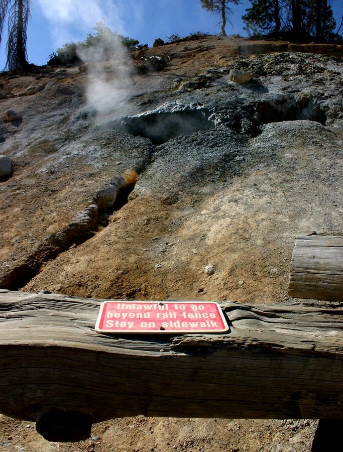
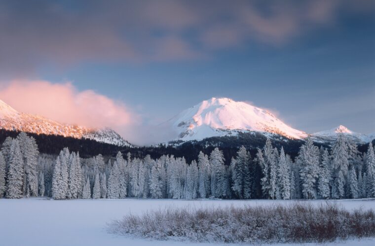
Photo: Genista via Flickr (CC BY-SA 2.0)
Our Lassen Volcanic National Park Weekend Itinerary for First-Time Visitors begins at Manzanita Lake just after sunrise, when the air smells of pine resin and the surface briefly reflects 10,457 foot Lassen Peak. Fine gravel presses underfoot on the lakeshore trail, Clark’s nutcrackers call from the ponderosa pines, and the summit’s snowfields brighten before the surrounding forest receives direct sun. The mountain looks close across the water, but its broad dome rises roughly 5,900 feet above the park’s lowest elevations.
A weekend provides enough time to cross the park on Lassen Volcanic National Park Highway, walk through an active hydrothermal basin, see landscapes altered by the 1915 eruptions, and choose one substantial hike. The most efficient plan enters through the Southwest Entrance, follows the 30 mile highway north, and finishes near Manzanita Lake. This order places the geothermal features and highest trailheads early on the first day, then saves the gentler lake, forest, and eruption history stops for the second.
How the weekend route fits together
Lassen occupies a transitional landscape where the southern Cascade Range meets the northern Sierra Nevada and the Great Basin. Elevations range from about 5,300 feet to the summit of Lassen Peak, creating large differences in snow depth, temperature, and vegetation within a relatively compact park. Red fir and mountain hemlock dominate higher slopes, while ponderosa pine, Jeffrey pine, and manzanita become more common at lower elevations.
The park highway connects the Southwest Entrance near the community of Mineral with the Northwest Entrance beside Manzanita Lake. Driving straight through takes about one hour, but that estimate excludes trail time, viewpoint stops, congestion, and slow travel on mountain curves. We recommend treating the highway as the backbone of the weekend rather than as a scenic drive to complete quickly.
A two-day route at a glance
The schedule below assumes the full park highway is open and that you arrive near the southwest side on Friday evening. It preserves most of Saturday for hydrothermal terrain and the park’s high country. Sunday concentrates on the northern volcanic landscape before departure through the Northwest Entrance.
| Day | Primary stops | Main highlight | Approximate driving |
|---|---|---|---|
| Friday evening | Mineral or another southern gateway | Positioning close to the Southwest Entrance | Depends on origin |
| Saturday | Sulphur Works, Bumpass Hell or Lassen Peak area, Kings Creek, Manzanita Lake | Hydrothermal features and high elevation scenery | About 30 miles, at least 1 hour behind the wheel |
| Sunday | Manzanita Lake, Loomis Plaza area, Chaos Crags or Devastated Area | Eruption history, lakeshore walking, and northern forests | About 15 to 30 minutes between the principal northern stops |
Why south to north works best
The Southwest Entrance sits at approximately 6,700 feet, close to Sulphur Works and the steep climb toward the park highway’s high point. Starting here avoids backtracking after visiting Bumpass Hell, Lassen Peak, and Kings Creek. It also puts the most physically demanding portion of the weekend before the easier Manzanita Lake circuit, which is useful when afternoon heat or fatigue builds.
Travelers arriving from Redding may find the Northwest Entrance more convenient. In that case, reverse the order and sleep near the southwest side after the first day. The individual stops still work, but begin early enough to reach Bumpass Hell before afternoon thunderstorms, which occur most often during summer’s warmer months.
Plan food, fuel, lodging, and road access before arrival
Services inside and immediately around Lassen are sparse compared with major national parks near larger resort towns. Mobile reception is unreliable, fuel is unavailable inside the park, and food choices may require a substantial detour. Download maps before leaving the regional highways and fill the tank in a gateway community rather than calculating around a nearly empty gauge.
Snow controls the practical season. The highway commonly remains partly or completely closed well into late spring, and deep drifts can persist near 8,000 feet after lower roads have dried. Current fees, campground status, trail closures, fire restrictions, and the extent of the plowed highway should be confirmed on the official park site before departure.
Choose a base that supports the route
For the south-to-north itinerary, spend Friday night in or near Mineral, along the southern approach, or in Chester if lodging availability and the longer morning drive make sense. On Saturday, camp near Manzanita Lake or continue to lodging outside the Northwest Entrance. Staying on opposite sides each night eliminates a second crossing of the mountain highway.
Campers should expect cold nights even after warm afternoons. Manzanita Lake stands near 5,900 feet, while camps and trailheads farther south sit higher. A nighttime temperature near freezing is possible during the shoulder seasons, and mountain weather can change rapidly after sunset.
Carry what the park cannot reliably provide
Our team packs for a full day away from commercial services. The following items solve the most common logistical problems:
- Water: Carry enough for hiking and driving, especially on exposed volcanic slopes where shade is limited.
- Lunch and snacks: Bring food before entering rather than depending on seasonal concessions.
- Offline navigation: Save the park map and driving directions to both entrances.
- Layers: Pack a warm layer and rain shell even when valley forecasts predict heat.
- Sun protection: Snowfields, pale pumice, and open ridges reflect intense sunlight at elevation.
- Traction when appropriate: Early season trails can retain hard snow long after nearby pavement clears.
Understand the volcanic landscape before hiking
Lassen contains examples of all four major volcano types found worldwide: shield volcanoes, composite volcanoes, cinder cones, and plug domes. Lassen Peak itself is a plug dome built from viscous dacite. Nearby Brokeoff Mountain is an eroded remnant of ancestral Mount Tehama, a much larger composite volcano that once occupied the southwest portion of the park.
Hydrothermal areas remain active because groundwater circulates through hot rock beneath the surface. Steam vents, acidic pools, and mud pots occur where this heated water reaches ground level. Their crusts can be thin enough to cause severe burns, so boardwalks and marked trails are safety infrastructure rather than optional route suggestions.
Saturday follows steam vents into the high country
Enter through the Southwest Entrance early enough to secure most of the day for walking. The route climbs quickly from the visitor area toward open slopes beneath Brokeoff Mountain and Lassen Peak. Snowbanks may line the road while lower forests are already dry, and temperatures at the highest parking areas can be considerably cooler than at Manzanita Lake.
Saturday’s central decision is choosing between Bumpass Hell and the Lassen Peak summit. Attempting both during an ordinary weekend produces a rushed day and leaves little time for the geological stops that explain the park. Most first-time visitors should choose Bumpass Hell because it combines active hydrothermal features with a moderate hike.
Begin with Sulphur Works
Sulphur Works lies close to the Southwest Entrance and provides the quickest introduction to Lassen’s hydrothermal system. A short paved path passes steaming ground, boiling mud, and sulfur stained soil beside the highway. The site occupies part of the eroded core of ancestral Mount Tehama, where circulating water can reach fractures connected to the volcano’s heat source.
Allow roughly 30 minutes rather than treating it as a roadside photograph. Morning air often makes the steam more visible, while shifting wind can carry the sharp odor of hydrogen sulfide across the path. Remain on the established walkway because apparently solid mineral crust can conceal scalding water and unstable ground.
Choose the day’s principal hike
The high elevation trailheads are where the itinerary can expand beyond the available daylight. Select one objective according to snow conditions, fitness, and interest, then preserve time for the drive north.
Bumpass Hell for geothermal variety
The Bumpass Hell Trail is approximately 3 miles round trip from the main trailhead. It crosses exposed slopes before descending into the park’s largest hydrothermal basin, where boardwalks pass Big Boiler, steaming vents, and opaque pools colored by heat tolerant microorganisms and altered minerals. The return climb feels harder because the basin sits below the trail’s initial traverse.
Lassen Peak for a summit objective
The Lassen Peak Trail climbs about 2,000 feet over approximately 5 miles round trip from a trailhead near 8,500 feet. The maintained route ascends open volcanic rubble with little shade, reaching broad views toward Mount Shasta, the Warner Mountains, and the Sacramento Valley when visibility is clear. Allow four to five hours, and turn around if thunderstorms begin building over the summit.
Complete Saturday without rushing the northern drive
After the principal hike, continue north while there is enough daylight to read the landscape rather than simply pass through it. The highway crosses its highest point near 8,512 feet, then descends through red fir forest toward Kings Creek and Summit Lake. Curves, wildlife, and roadside snow can keep speeds low. Plan at least two hours between leaving the hike and reaching Manzanita Lake, including one short walk and several overlooks.
Pause at Kings Creek Meadow
Kings Creek Meadow spreads below Lassen Peak at roughly 7,300 feet. Snowmelt feeds the creek, while seasonal saturation prevents conifers from occupying the meadow’s center. Look for mule deer near the forest edge and watch for wet ground beside informal paths. The roadside viewpoint provides the broadest composition, with the creek, grasses, and volcanic dome aligned in one view.
Save time for the Devastated Area
The half mile interpretive loop at the Devastated Area explains the May 22, 1915 eruption, when a pyroclastic flow and lateral blast swept across the northeast side of Lassen Peak. Volcanic rocks scattered around the trail include dacite blocks transported by the eruption. This stop supplies essential context for the bare slopes visible above the regenerating lodgepole pine forest.
End the day beside Manzanita Lake
Walk the approximately 1.5 mile Manzanita Lake loop if daylight and energy remain. The mostly level route passes willow thickets, forest, and open shoreline, with the clearest view of Lassen Peak usually found along the lake’s northwestern side. Mosquitoes can be persistent near dusk during early summer, so keep repellent accessible rather than buried with overnight gear.
Use Sunday for eruption history and northern trails
Sunday concentrates several worthwhile stops within a short drive of the Northwest Entrance. Begin at the Loomis Plaza area to orient yourself to the park’s eruption history, then choose between a forest hike and a slower lakeshore morning. Leaving the northern section for the second day also creates flexibility if Saturday’s high elevation hike takes longer than expected.
Choose the essential morning stops
A practical sequence keeps backtracking to a minimum:
- Walk Manzanita Lake early, if you did not complete the loop Saturday.
- Examine the historic photographs and geological interpretation around the Loomis Plaza area.
- Drive southeast to the Devastated Area if Saturday ended too late for its interpretive trail.
- Return toward the Northwest Entrance for an optional longer hike before departure.
Add Chaos Crags if you have four hours
The Chaos Crags Trail covers approximately 4 miles round trip and gains about 850 feet. It climbs through forest to Chaos Crags Overlook, where pale dacite domes rise above the Chaos Jumbles rockfall. The Jumbles formed roughly 350 years ago when part of a dome collapsed, sending debris toward the Manzanita Lake area. Loose surfaces and steady climbing make this a more demanding choice than the mileage suggests.
Keep an easier alternative ready
Families and tired hikers can substitute the Lily Pond Nature Trail, a short forest loop near Manzanita Lake. The route introduces the wetter plant communities of the park’s lower northern elevations without requiring another major climb. Allow extra time to scan ponds and forest margins for birds, but never approach bears or deer encountered along the trail.
Adjust the route to snow, heat, and daylight
The Lassen Volcanic National Park Weekend Itinerary for First-Time Visitors works most predictably after the highway has opened fully and major trails have lost their continuous snow cover. Calendar dates alone are unreliable because winter accumulation varies sharply. A warm spring can expose low elevation trails while Bumpass Hell, Lassen Peak, and the highway’s upper section remain buried.
When the through road is closed, treat the southwest and northwest entrances as separate destinations. Driving between them outside the park requires a long regional detour, so a weekend based at one entrance is usually more productive. Winter visitors can explore plowed access areas and snow routes, but avalanche terrain, navigation, and rapidly changing weather require skills beyond an ordinary summer hiking plan.
Seasonal planning comparison
| Period | Likely conditions | Best adjustment |
|---|---|---|
| Late spring | Deep snow at higher elevations, partial road access, cold nights | Base the trip at one entrance and carry traction for icy trails |
| Summer | Best chance of full road access, exposed high country, afternoon storms | Start major hikes early and carry more water than the lake walks require |
| Early autumn | Cool mornings, shorter daylight, fewer insects | Move the longest hike earlier and pack layers for shaded basins |
| Winter | Heavy snow, closed through road, limited vehicle access | Plan a snow travel trip from a single entrance rather than the full itinerary |
Frequently Asked Questions
First visits often fail because travelers underestimate elevation, snow retention, or the distance between basic services. The answers below address the decisions that most directly affect a two day plan. Trail conditions still deserve careful attention because a dry road near Manzanita Lake says little about snow depth several thousand feet higher on Lassen Peak.
Can you see Lassen Volcanic National Park in two days?
Two days cover the park highway, one substantial hike, Sulphur Works, the Devastated Area, and Manzanita Lake. Cinder Cone, Butte Lake, and Warner Valley require separate access roads and belong in a longer visit.
Is the itinerary suitable for children?
Manzanita Lake, Sulphur Works, and the Devastated Area suit many families. Bumpass Hell includes exposed terrain and a return climb, while children must remain closely supervised around every hydrothermal feature.
Are dogs allowed on Lassen trails?
Pets are generally excluded from park trails and backcountry areas. They may accompany visitors in specified developed areas, but hot pavement, summer temperatures, and limited shade make leaving a pet unattended unsafe.
When does the park highway open?
There is no dependable annual opening date. Snow removal begins before the road opens through the park, and the highest section can remain closed after both entrance areas become accessible.
Can you swim in Manzanita Lake?
Manzanita Lake is cold even in summer because of its elevation and snow fed setting. Anyone entering the water should account for rapid cooling, changing wind, and the absence of warm shoreline conditions common at lower elevation lakes.
A workable first weekend at Lassen
The strongest weekend plan follows the park’s geography: enter from the southwest, study active hydrothermal terrain, choose one high elevation hike, and descend through the 1915 eruption landscape. A night near Manzanita Lake then positions Sunday’s shorter walks and northern volcanic features without requiring another full highway crossing.
Keep the plan disciplined. Bumpass Hell and Lassen Peak compete for the same block of time, while Chaos Crags is an optional second day objective rather than a required stop. With fuel, food, offline maps, and seasonal road conditions handled before arrival, two days provide a coherent introduction to Lassen’s plug domes, hydrothermal system, eruption history, and elevation driven ecosystems.
Want to keep exploring? Browse all our Lassen Volcanic guides and articles for more trip-planning tips and ideas.
Gear & Essentials
Tell us about your trip and we will add what else you will want:
The basics
Worth having in the car whatever the park.
For this trip
As an Amazon Associate we earn from qualifying purchases, at no extra cost to you.