5 Best Hikes in Rocky Mountain National Park
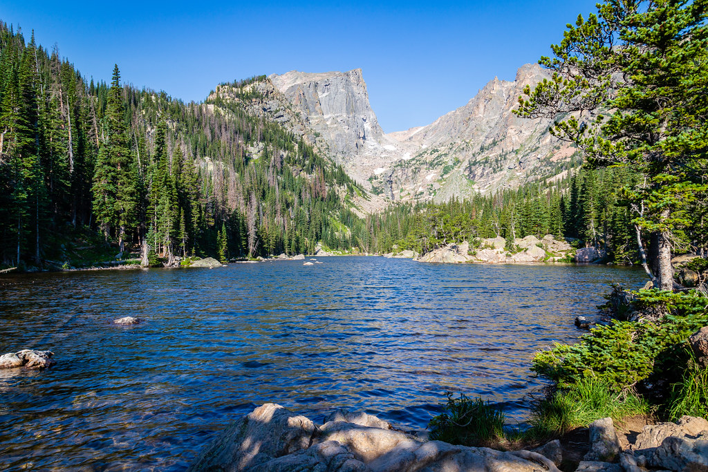
Photo: aparlette via Flickr (CC BY 2.0)
The best hikes Rocky Mountain National Park has to offer climb from dense subalpine forest into glacial basins framed by peaks above 12,000 feet. Our five selections cover the park’s defining experiences: the chain of lakes above Bear Lake, the granite walls surrounding Sky Pond, the alpine terrain of Flattop Mountain, the dramatic approach to Chasm Lake, and the waterfalls of Wild Basin.
This guide compares the routes by distance, elevation gain, terrain, and seasonal conditions. It also explains where each trail begins and how altitude, afternoon storms, parking constraints, and lingering snow should influence your plan.
What Defines Hiking in Rocky Mountain National Park
Rocky Mountain National Park spans the Continental Divide, with elevations ranging from about 7,600 feet to 14,259 feet on Longs Peak. Most celebrated day hikes start above 8,000 feet, so visitors arriving from lower elevations often feel the altitude immediately. A moderate pace, steady hydration, and an easier first day can prevent a promising hike from ending at the first steep switchback.
Glaciers Shaped the Park’s Signature Routes
The eastern side contains the park’s greatest concentration of accessible glacial terrain. Ancient ice excavated bowl shaped cirques, sharpened ridgelines, and left strings of lakes in valleys such as Tyndall Gorge and Glacier Gorge. Emerald Lake, Chasm Lake, and Sky Pond occupy basins enclosed by cliffs of Precambrian granite and gneiss. Their trails reveal the landscape in stages, moving from lodgepole pine into spruce and fir forest, then through krummholz and exposed tundra.
Three Trail Corridors Organize the Experience
Bear Lake Road provides access to Emerald Lake, Flattop Mountain, and Sky Pond. Longs Peak Road leads to the Chasm Lake trailhead, while Wild Basin Road serves Ouzel Falls. These corridors are separated enough that changing trailheads midway through a hiking day wastes time. We recommend choosing one corridor each day and pairing the main hike with nearby overlooks or short nature trails.
How We Chose the 5 Best Hikes in Rocky Mountain National Park
Our list favors routes that reveal a distinct part of the park rather than five variations of the same lake walk. Each hike has a clear scenic payoff, follows an established trail, and can be completed as a day trip by hikers prepared for its distance and elevation. Difficulty reflects altitude and terrain as well as mileage.
Best Hikes Rocky Mountain National Park Comparison
| Hike | Round trip distance | Approximate gain | High point | Difficulty |
|---|---|---|---|---|
| Emerald Lake | 3.6 miles | About 650 feet | 10,110 feet | Moderate |
| Sky Pond | About 9.5 miles | About 1,800 feet | About 10,900 feet | Strenuous |
| Chasm Lake | About 8.5 miles | About 2,500 feet | 11,760 feet | Strenuous |
| Flattop Mountain | About 8.8 miles | About 2,850 feet | 12,324 feet | Strenuous |
| Ouzel Falls | About 5.4 miles | About 960 feet | About 8,500 feet | Moderate |
Matching the Best Hikes in Rocky Mountain National Park to Your Ability
Emerald Lake and Ouzel Falls suit hikers who want a half day outing without sustained alpine exposure. Sky Pond adds wet rock, a steep scramble beside Timberline Falls, and a longer commitment. Chasm Lake combines considerable climbing with exposed terrain near Peacock Pool. Flattop Mountain has no technical climbing on the standard trail, but its prolonged ascent and time above treeline demand endurance and careful weather judgment.
Planning for the Best Hikes Rocky Mountain Conditions
Snow can cover upper trails well into June, while autumn storms may restore winter conditions by October. July through September generally provides the clearest access to alpine lakes and tundra, but summer also brings frequent afternoon thunderstorms. Start exposed routes around dawn so you can descend below treeline before lightning develops over the Divide.
Trailheads, Parking, and Seasonal Access
Bear Lake is one of the park’s busiest trailheads, and its parking area often fills early. Seasonal shuttle systems may connect lower parking areas with Bear Lake Road stops. Entry reservations, shuttle operations, trail closures, and fees can change, so confirm current details on the official park site before departure. Our team also recommends reviewing the bridge replacement and trail closure update above Nymph Lake when planning the Emerald Lake corridor.
What to Carry Above 10,000 Feet
Conditions can change from warm sun to cold rain or hail within minutes. Shade becomes limited near treeline, and snowfields can remain firm early in the day. For the longer routes, our standard day pack includes:
- At least two liters of water per person, plus a filter for emergencies
- High energy food with enough calories for an unplanned delay
- A waterproof shell and an insulating layer
- Sun protection, including sunglasses and sunscreen
- A paper map or downloaded map that works without cellular service
- Traction devices when packed snow or ice remains on the route
- A headlamp, even when the planned return is before sunset
The First Two of the 5 Best Hikes in Rocky Mountain National Park
Emerald Lake and Sky Pond begin in the Bear Lake corridor but deliver very different days. Emerald Lake is a compact introduction to the park’s glacial lakes. Sky Pond follows Glacier Creek deeper into the mountains, eventually reaching a rock enclosed basin beneath some of the park’s most recognizable spires.
1. Emerald Lake via Nymph Lake and Dream Lake
The Emerald Lake Trail begins near 9,475 feet at Bear Lake. It climbs first to shallow Nymph Lake, known for its summer lily pads, then reaches Dream Lake beneath Hallett Peak. The final segment ascends through spruce and fir forest to Emerald Lake, where Flattop Mountain and Hallett Peak form the steep western wall of Tyndall Gorge. The modest mileage makes this route popular, but snow and polished ice can complicate its shaded sections.
What the Final Approach Feels Like
Beyond Dream Lake, the trail grows rougher underfoot, with stone steps and exposed roots interrupting the climb. Cold air often drains down the gorge even when Bear Lake feels warm. At Emerald Lake, the trees open abruptly onto dark water and broken granite. Hallett Peak rises more than 2,600 feet above the basin, while wind moves across the lake with little warning and muffles voices along the shore.
2. Sky Pond through Glacier Gorge
Sky Pond can begin at the Glacier Gorge trailhead or from Bear Lake, depending on access and parking. The route passes Alberta Falls, follows Glacier Creek toward The Loch, and then climbs into a narrowing valley below Taylor Peak and Powell Peak. The Loch provides a sensible turnaround point if weather deteriorates, since the most demanding terrain begins beyond its western shore.
Timberline Falls and the Upper Basin
Reaching Lake of Glass requires climbing a steep rock chute beside Timberline Falls. Water frequently coats the handholds, and descending can be harder than ascending, especially when ice remains. Above the chute, the path continues past Lake of Glass to Sky Pond beneath the Sharkstooth, Petit Grepon, and the Saber. Hikers uncomfortable with scrambling or wet exposure should turn around below the falls rather than attempt terrain beyond their ability.
Three Routes Beyond the Bear Lake Corridor
The remaining hikes spread across three distinct landscapes: the granite wall below Longs Peak, the exposed Continental Divide, and the lower waterfalls of Wild Basin. Chasm Lake and Flattop Mountain require long climbs at high elevation. Ouzel Falls stays below treeline and provides a useful alternative when clouds are already building over the alpine zone.
3. Chasm Lake Beneath Longs Peak
From the Longs Peak trailhead near 9,400 feet, the route climbs through lodgepole pine before reaching the exposed slopes above treeline. At the Chasm Lake junction, leave the Keyhole Route and cross toward Peacock Pool. A narrow ledge section precedes the final climb into the basin. Chasm Lake sits at 11,760 feet beneath the Diamond, the sheer east face of 14,259 foot Longs Peak. Snowfields and ice can persist around the lake after lower trails have dried.
Where to Make the Turnaround Decision
The Chasm Lake junction provides a valuable weather checkpoint because the remaining route becomes increasingly exposed. Clouds forming over Longs Peak, nearby thunder, or strong electrical winds are reasons to descend immediately. Peacock Pool offers another decision point before the ledges. Mountain goats and bighorn sheep may occupy the surrounding slopes, so give them room and protect unattended packs from salt seeking wildlife.
4. Flattop Mountain from Bear Lake
The Flattop Mountain Trail climbs steadily past the Dream Lake overlook and continues through increasingly wind shaped forest. Above treeline, cairns mark the broad tundra route toward the 12,324 foot summit. The top is a wide plateau rather than a pointed peak, but views extend into Tyndall Gorge and across the Continental Divide. Strong wind, limited shelter, and deceptively similar terrain can make navigation difficult when fog, blowing snow, or low cloud obscures the trail.
5. Ouzel Falls in Wild Basin
Ouzel Falls begins from the Wild Basin corridor in the park’s southeastern corner. The trail follows the North St. Vrain drainage past Copeland Falls and the broad granite shelves of Calypso Cascades before reaching the roughly 40 foot waterfall. Forest cover makes this route less exposed than the alpine selections, although wet rocks near the cascades remain slippery. The trail also serves as an approach to Ouzel Lake and Bluebird Lake for hikers prepared to extend the day.
Choosing Among the 5 Best Hikes in Rocky Mountain National Park
The Best Hikes Rocky Mountain choices depend as much on conditions as fitness. Emerald Lake works well during a short weather window, while Ouzel Falls provides greater tree cover on a warm day. Flattop Mountain demands the clearest forecast because much of its upper route crosses open tundra. Chasm Lake and Sky Pond both contain terrain where lingering snow or ice can raise the difficulty substantially.
Seasonal Conditions by Route
Trail conditions change first with elevation and then with exposure. South facing slopes may dry while shaded gullies remain icy, so footwear decisions should reflect the hardest section rather than the trailhead. This comparison summarizes the durable seasonal pattern rather than a daily forecast.
| Route | Typical summer concern | Shoulder season concern |
|---|---|---|
| Emerald Lake | Crowds and afternoon showers | Ice in shaded forest |
| Sky Pond | Wet rock at Timberline Falls | Snow in the falls chute |
| Chasm Lake | Lightning above treeline | Snow near Peacock Pool |
| Flattop Mountain | Wind and full exposure | Obscured trail across tundra |
| Ouzel Falls | Slippery cascade viewpoints | Packed snow beneath trees |
A Practical Two Day Pairing
Use the shorter route to assess how your body responds to altitude before committing to a strenuous climb. A sensible sequence is:
- Hike Emerald Lake or Ouzel Falls on the first morning, maintaining a pace that allows comfortable conversation.
- Rest, replace fluids, and watch for persistent headache, nausea, unusual fatigue, or poor coordination.
- Choose Sky Pond, Chasm Lake, or Flattop Mountain the next day only if everyone has recovered and the alpine forecast remains stable.
Protecting Tundra, Water, and Wildlife
Rocky Mountain tundra grows slowly because plants face wind, ultraviolet exposure, and a growing season that may last only several weeks. Stay on the constructed trail and durable rock, especially on Flattop Mountain. A single shortcut can break vegetation that requires decades to recover. Around lakes, use established resting areas and keep food crumbs out of talus where marmots and pikas forage.
Trail Conduct in Busy Basins
Yield to uphill hikers where the trail is narrow, and wait in durable areas rather than stepping into meadow vegetation. Keep at least 75 feet from elk and other large mammals, and increase that distance whenever an animal changes direction or watches you closely. Dogs are prohibited on park trails, including leashed pets. Pack out tissues, fruit peels, and food scraps, all of which alter wildlife behavior and decompose slowly in the cold alpine environment.
Build Your Rocky Mountain Hiking Plan
These five hikes create a useful progression through the park. Emerald Lake introduces the glacial basins above Bear Lake, Ouzel Falls follows a forested watershed, and Sky Pond reaches a rugged cirque through technical terrain. Chasm Lake places hikers beneath the Diamond of Longs Peak, while Flattop Mountain delivers the longest sustained exposure to tundra and the Continental Divide.
Select the route according to altitude experience, weather, and current trail surfaces rather than mileage alone. Start early, establish turnaround points before leaving the trailhead, and save exposed objectives for stable mornings. That approach leaves enough flexibility to enjoy Rocky Mountain National Park while respecting the conditions that shape every hike.
Want to keep exploring? Browse all our Rocky Mountain guides and articles for more trip-planning tips and ideas.
Gear & Essentials
Tell us about your trip and we will add what else you will want:
The basics
Worth having in the car whatever the park.
For this trip
Traveling with kids
Bringing a pet
RVing
Backcountry
Winter conditions
On the water
Photography
Accessibility
As an Amazon Associate we earn from qualifying purchases, at no extra cost to you.