How to Get to Yosemite National Park: Airports, Roads and Getting Around
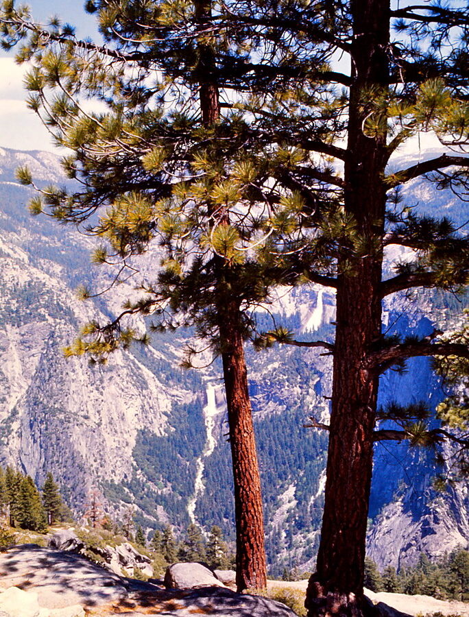
Photo: Ladycliff via Flickr (CC BY 2.0)
If your search began with How Get Yosemite National Park, the practical answer starts with choosing an airport and entrance road that match the part of Yosemite you intend to visit. Most first-time trips center on Yosemite Valley, about 95 road miles from Fresno Yosemite International Airport and roughly 190 miles from San Francisco International Airport.
Yosemite covers nearly 1,200 square miles, and its roads cross major elevation zones. Yosemite Valley sits near 3,960 feet, Wawona is around 4,000 feet, and Tuolumne Meadows is approximately 8,600 feet. A route that works for the Valley in April may provide no access to Tuolumne Meadows because Tioga Road remains buried in snow.
How to Get to Yosemite National Park: Start with Your Actual Destination
Set your navigation for a specific park district, lodging property, campground, or entrance rather than simply entering “Yosemite.” Mapping software may select a seasonal road, place you at the wrong gate, or treat Yosemite Valley and Tuolumne Meadows as nearby destinations. They are connected by mountain roads that require substantial driving even when every route is open.
Match the entrance to your park base
Yosemite Valley is the usual base for Yosemite Falls, El Capitan, Half Dome viewpoints, and the Mist Trail. Travelers staying near Wawona or visiting the Mariposa Grove generally approach on California Highway 41. Those headed to Hodgdon Meadow or the western end of Tioga Road often use Highway 120 from Groveland. Highway 140 through Mariposa and El Portal provides the lowest-elevation approach to Yosemite Valley.
Tuolumne Meadows, Tenaya Lake, and the Cathedral Lakes trailheads lie along Tioga Road. When the road is open, they can be approached from Highway 120 east over Tioga Pass or from the park’s western entrances. Tioga Pass reaches 9,945 feet, making it unsuitable as a winter route and vulnerable to early autumn snow.
Build the route in the right order
- Choose your overnight base. Determine whether you are sleeping in Yosemite Valley, Wawona, the Highway 140 corridor, the Highway 120 corridor, or east of Tioga Pass.
- Select an entrance road. Account for mountain driving, seasonal closures, and the direction of your wider California itinerary.
- Choose the airport. Compare total driving time, rental-car cost, flight schedule, and late-night arrival risks.
- Download offline maps. Mobile coverage is unreliable in the Merced River Canyon, along Tioga Road, and across large sections of the park.
- Check operating conditions. Entrance reservations, fees, chain controls, road status, and shuttle schedules can change, so confirm current details on the official park site before departure.
How to Get to Yosemite National Park: Choosing the Best Airport
No commercial airport sits beside Yosemite Valley. Fresno offers the shortest practical drive among airports with a broad selection of scheduled flights and rental cars. Merced is closer by mileage but has limited air service. Bay Area and Sacramento airports provide more flight choices, although traffic through the Central Valley and Sierra foothills can add hours.
| Airport | Approximate distance to Yosemite Valley | Typical drive without long stops | Best use |
|---|---|---|---|
| Fresno Yosemite International | 95 miles | 2.5 to 3 hours | Highway 41, Wawona, and Mariposa Grove itineraries |
| Merced Regional | 80 miles | 2 to 2.5 hours | Limited-service option near Highway 140 |
| San Francisco International | 190 miles | 4 to 5 hours | International flights and large rental-car selection |
| Oakland International | 180 miles | 3.5 to 4.5 hours | East Bay departure with less city driving |
| San Jose Mineta International | 170 miles | 3.5 to 4.5 hours | Trips combining Yosemite with the South Bay or Monterey region |
| Sacramento International | 175 miles | 3.5 to 4 hours | Highway 120 approach and northern California itineraries |
| Reno Tahoe International | 220 miles via Tioga Pass | 4.5 to 5.5 hours when Tioga Road is open | Summer access from the eastern Sierra |
How to Get to Yosemite National Park from a California Airport
From Fresno, Highway 41 climbs through oak woodland and conifer forest before reaching the South Entrance near Mariposa Grove. From Merced, Highway 140 follows the Merced River through Mariposa and El Portal. San Francisco, Oakland, San Jose, and Sacramento travelers generally cross the Central Valley before choosing Highway 120, Highway 140, or Highway 41.
Allow additional time for urban traffic, food, fuel, and winter chain installation. A flight landing late in the evening can lead to several hours of dark mountain driving, with sharp curves and wildlife on the road. Our team generally favors an airport hotel or foothill stop after a late arrival rather than entering the park tired.
When Reno makes sense
Reno works well for a summer trip that includes Mono Lake, Lee Vining, Tuolumne Meadows, or the eastern Sierra. The route follows U.S. 395 south and climbs Highway 120 to Tioga Pass. When Tioga Road closes, Reno loses its direct connection to Yosemite Valley, and the necessary detour around the Sierra can consume most of a day.
How to Get to Yosemite National Park via Its Four Approach Roads
Yosemite has no single main entrance. Highways 41, 140, and 120 west remain the principal western approaches, while Highway 120 east crosses Tioga Pass seasonally. None is an interstate-style road. Expect two-lane pavement, curves, steep grades, slower recreational vehicles, and occasional delays caused by snow, rockfall, construction, or wildlife.
How to Get to Yosemite National Park through the western entrances
Highway 140 through Mariposa and El Portal
Highway 140 follows the Merced River into the park through Arch Rock Entrance. Its lower elevation and comparatively gradual climb make it the preferred winter approach for many drivers. The final section passes steep canyon walls where rockfall can affect traffic. It is convenient for accommodations west of the park and leads directly toward Yosemite Valley.
Highway 41 through Wawona
Highway 41 is the logical route from Fresno and the South Entrance. It serves Mariposa Grove and Wawona before continuing toward the Valley. The road climbs and curves extensively, and winter storms can create chain-controlled conditions. Its defining arrival comes after the Wawona Tunnel, where Tunnel View reveals El Capitan, Half Dome, Bridalveil Fall, and the glacially carved valley.
At Tunnel View, the pavement gives way to a stone overlook above the forest. Cool air often drains through the opening, while traffic noise fades beneath wind in the pines and the distant sound of Bridalveil Fall. The granite walls appear abruptly after the dark tunnel, with the Valley floor nearly 1,500 feet below El Capitan’s summit-facing cliffs.
Highway 120 from Groveland
Highway 120 enters at Big Oak Flat and is useful from Sacramento, Oakland, and northern Bay Area origins. The approach crosses dry foothill oak woodland before climbing into mixed conifer forest. Grades near the Priest Grade area and the descent toward Yosemite Valley require lower gears, particularly for RVs and heavily loaded vehicles.
Tioga Pass from the eastern Sierra
Highway 120 east rises from Lee Vining near Mono Lake to Tioga Pass, then traverses about 47 miles of high country toward Crane Flat. Along the way it passes Tuolumne Meadows, granite domes, Tenaya Lake, and trailheads for Cathedral Lakes and Clouds Rest. Snow commonly closes this route from autumn until late spring or early summer, with the opening date determined by snowpack and road-clearing progress.
Getting Around Yosemite National Park After You Arrive
Driving to the correct entrance solves only part of the transportation problem. Yosemite Valley’s roads form a mostly one-way circulation system, and congestion builds around trailheads, lodging areas, and major viewpoints. Once you secure a legal parking space, walking, cycling, or using the Valley shuttle usually saves time. Moving the car between short stops can leave you searching for another space several times in one day.
Choose the right Valley transportation
| Method | Best for | Important limitation |
|---|---|---|
| Valley shuttle | Major lodging areas, visitor services, and popular trailheads | Routes and operating patterns vary by season |
| Bicycle | Trips between eastern Valley landmarks | Bikes belong on paved roads and designated bicycle paths, not hiking trails |
| Walking | Yosemite Village, Yosemite Falls, and nearby viewpoints | Distances become substantial when connecting opposite ends of the Valley |
| Private vehicle | Early departures and destinations outside shuttle coverage | Parking becomes difficult during busy daytime periods |
Use the shuttle for the eastern Valley
The Valley shuttle connects many heavily visited areas around Yosemite Village, Curry Village, and the eastern trailhead corridor. It is particularly useful for reaching the area near the Mist Trail and Mirror Lake approaches without relocating a vehicle. Shuttle travel still takes time because buses share portions of the road network with other traffic, so leave a generous margin for timed tours, dinner bookings, or a long hike.
Use a car for outlying districts
Glacier Point Road, Wawona, Hetch Hetchy, Crane Flat, and the Tioga Road corridor require separate planning because the Valley shuttle does not create a park-wide transit network. Glacier Point stands at 7,214 feet and is about 30 road miles from Yosemite Valley. Hetch Hetchy lies behind its own access road off Highway 120, while Tuolumne Meadows requires a high-country drive when Tioga Road is open.
How to Get to Yosemite National Park Without a Rental Car
Travelers can combine rail or intercity bus service with regional transportation into Yosemite, but the itinerary requires closer attention than a rental-car trip. Amtrak San Joaquins trains serve Merced, where passengers can connect toward the Highway 140 corridor and Yosemite Valley. Regional buses also run from several gateway communities. Service frequency, baggage rules, and seasonal reach determine whether the trip works for your dates.
Plan the final connection before booking flights
Start with the park arrival time and work backward through every transfer. A delayed flight can break a same-day rail and bus connection, especially late in the afternoon. Build an overnight in Merced or another gateway community when the schedule has little tolerance. The shorthand question How Get Yosemite National Park without a car therefore has a practical answer: secure the final regional connection first, then select the flight or train that feeds it reliably.
Know where car-free travel works best
A car-free itinerary works most smoothly when lodging and activities remain in Yosemite Valley. Travelers planning sunrise photography at Glacier Point, hiking from remote Tioga Road trailheads, or visiting Hetch Hetchy gain far less flexibility from Valley transportation. Check walking distances from your overnight accommodation to food, shuttle stops, and trailheads, particularly if you carry climbing equipment, child gear, or several days of luggage.
Prepare for Snow, Closures, and Delays
Sierra weather can alter the final hours of a journey even when roads in the Central Valley remain dry. Storms may bring snow to Highway 41, Highway 120, and upper sections of Highway 140. Rockfall can affect the Merced River Canyon, while wildfire smoke or emergency activity may redirect traffic during warmer months. Keep enough fuel to reverse course and reach a gateway town.
Carry and understand tire chains
California chain controls can require motorists to carry or install traction devices, including drivers of four-wheel-drive and all-wheel-drive vehicles. Rental agreements sometimes restrict chain use, so read the contract before leaving the airport. Practice identifying the drive wheels and chain attachment points in daylight. Waterproof gloves, a kneeling pad, a headlamp, and a compact snow brush make roadside installation safer and faster.
Do not trust a summer detour in winter
When Tioga Pass closes, nearby Sonora Pass often closes for the same seasonal conditions. Navigation apps may suggest mountain roads that are gated, unplowed, or unsuitable for the vehicle. Use a dependable year-round Sierra crossing, even when it adds considerable mileage. Save offline maps and carry these essentials:
- A paper California highway map for broad rerouting
- A charging cable and backup battery
- Warm layers, water, and food for an extended delay
- An ice scraper and windshield fluid rated for freezing temperatures
- The address and phone number of the first night’s accommodation
A Reliable Arrival Plan
Choose the park district first, then align the entrance, airport, and overnight stop with that destination. Highway 140 provides the lower-elevation western approach, Highway 41 serves Wawona and the South Entrance, Highway 120 west suits northern approaches, and Tioga Pass functions as a seasonal eastern gateway. Once inside Yosemite Valley, park once when possible and shift to walking, cycling, or shuttle transportation.
Build extra time around every transition: collecting a rental car, crossing the Central Valley, buying supplies, installing chains, and navigating after dark. A route saved offline and a backup for seasonal closures prevent most arrival problems. With those decisions settled before departure, your first day can begin at the intended trailhead or viewpoint instead of in an avoidable detour.
Want to keep exploring? Browse all our Yosemite guides and articles for more trip-planning tips and ideas.
Gear & Essentials
Tell us about your trip and we will add what else you will want:
The basics
Worth having in the car whatever the park.
For this trip
Traveling with kids
Bringing a pet
RVing
Backcountry
Winter conditions
On the water
Photography
Accessibility
As an Amazon Associate we earn from qualifying purchases, at no extra cost to you.