Visiting Denali National Park with Limited Mobility: Accessible Views and Trails
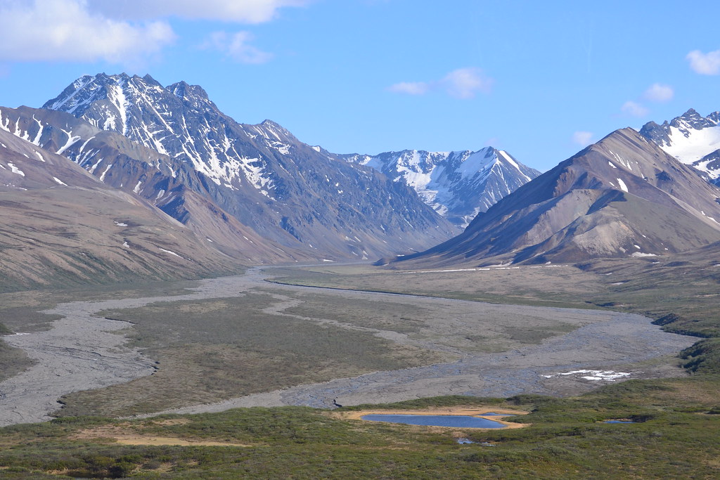
Photo: larrywkoester via Flickr (CC BY 2.0)
Visiting Denali National Park with limited mobility can begin at Mountain Vista near sunrise, when tires and shoes roll quietly over firm gravel and cold air drains from the Alaska Range. On a clear morning, Denali rises above the tundra nearly 50 miles away, its snowfields catching light before the spruce forest warms. The open terrain provides a sense of scale that enclosed roadside viewpoints cannot match.
Accessible travel here depends on understanding one road, several distinct visitor zones, and the difference between an accessible viewpoint and an accessible trail. Our team uses those distinctions below to help travelers choose practical stops, arrange transportation, and experience Denali’s taiga, tundra, wildlife, and mountain scenery without assuming long walks or steep terrain.
Understanding Denali Before Choosing Your Stops
Visiting Denali National Park with Limited Mobility Starts with One Road
Denali National Park and Preserve covers roughly six million acres, yet almost every first visit follows the Denali Park Road. It begins at Alaska Highway 3, commonly called the Parks Highway, and runs 92 miles west toward Kantishna. Summer private vehicle access generally ends around Savage River at Mile 15. Beyond that point, most visitors use park buses, while current landslide work can shorten the portion of the western road available to public travel.
The entrance lies about 120 road miles south of Fairbanks and approximately 240 miles north of Anchorage. Driving from Fairbanks commonly takes around two hours before stops. Anchorage requires roughly five hours in favorable conditions. Alaska Railroad service also reaches the park entrance, placing passengers near the principal visitor area without requiring them to drive the Parks Highway.
Elevation, Weather, and Surface Conditions
The entrance area sits at approximately 1,700 feet, while Denali reaches 20,310 feet, the highest summit in North America. Visitors remain far below the summit, but weather still changes rapidly as air moves across the Alaska Range. A calm 60 degree afternoon can become cold and wet after clouds arrive. Snow can fall at higher roadside elevations outside the conventional winter season.
Accessibility also changes with the ground. Paved visitor facilities are concentrated near the entrance, while many trail surfaces consist of compacted gravel, roots, loose stones, or wooden boardwalk. Permafrost causes settling and unevenness. Travelers using wheelchairs, walkers, or canes should plan around surface quality and grade rather than relying only on published trail distance.
| Area | Road location | Typical surface | Best limited mobility experience |
|---|---|---|---|
| Entrance and Riley Creek | Miles 0 to 1.5 | Pavement and maintained paths | Visitor services, exhibits, taiga scenery |
| Mountain Vista | Mile 13 | Compacted accessible trail | Denali and Alaska Range views |
| Savage River | Mile 15 | Roadside surfaces and rocky trail | River canyon scenery from near the road |
| Restricted road corridor | West of Mile 15 | Bus travel with roadside stops | Wildlife, tundra, braided rivers, distant peaks |
Build an Accessible Transportation Plan
Getting from the Entrance to the Main Visitor Area
The entrance district is spread along the first few miles of the park road. The railroad depot, Denali Visitor Center campus, Riley Creek area, and bus facilities are close by Alaska standards, but the distance between them can still be tiring. Seasonal park transportation commonly links major facilities. Travelers should avoid assuming every stop is within comfortable walking or rolling distance, especially when carrying oxygen equipment, photography gear, or rain layers.
If arriving by car, identify the correct parking area before leaving the highway corridor. Mobile reception becomes unreliable farther into the park, so save maps and reservation details offline. Accessible parking placards should be displayed as required, and anyone transferring from a vehicle should allow room for ramps or lifts in crowded lots.
Visiting Denali National Park by Accessible Bus
Bus travel provides the broadest low-exertion view of Denali’s interior. The road passes black spruce forest, open tundra, glacial rivers, and slopes used by caribou, moose, Dall sheep, grizzly bears, and wolves. Wildlife sightings are never guaranteed, but sitting higher in a bus can improve visibility across brush and river bars.
Accessible buses or accommodations for mobility devices may require advance coordination. Ask about lift dimensions, combined passenger and device weight limits, securement systems, boarding assistance, trip duration, and opportunities to leave the bus. Road endpoints, reservations, fares, operating dates, and disability permits are operational details that change, so confirm current arrangements on the official park site. Our Denali Park Road opening report also illustrates how seasonal access expands in stages.
Questions to Ask Before Reserving
- Can the assigned bus carry the specific wheelchair or scooter model?
- Is the traveler able to remain in the mobility device during travel?
- How long is the trip without a guaranteed indoor break?
- Which stops have level boarding areas?
- Can essential medication, food, water, and mobility batteries remain within reach?
- Is a disability road travel permit appropriate when bus use is medically impractical?
Visiting Denali National Park with Limited Mobility Through Three Accessible Zones
The Entrance Campus and Boreal Forest
The entrance area occupies the northern boreal forest, also called taiga. White spruce grow on warmer, better-drained slopes, while black spruce tolerate colder soils underlain by permafrost. Moose browse willow thickets, snowshoe hares use dense cover, and red squirrels leave piles of cone scales beneath spruce trees. This ecosystem is easy to overlook when attention is fixed on Denali itself, yet it represents much of the park’s lower terrain.
Denali Visitor Center Area
The main visitor campus provides the most straightforward orientation for travelers with limited stamina. Exhibits explain Denali’s geology, wildlife, human history, and subarctic ecology, while nearby maintained paths offer short exposures to the forest. Trail names around the campus can be misleading for accessibility purposes. The McKinley Station, Rock Creek, and Horseshoe Lake routes include natural surfaces, elevation change, roots, or steep sections, so they should not be treated as wheelchair trails merely because their trailheads are near developed facilities.
Mountain Vista and the Open Tundra
Mountain Vista at Mile 13 is the strongest combination of low physical demand and expansive scenery along the private vehicle portion of the road. Its approximately 0.6 mile loop was designed as an accessible trail and crosses open terrain with views toward the Alaska Range. The landscape also reveals the transition from spruce forest to tundra, where exposure, colder soils, and wind restrict tree growth.
How to Use the Mountain Vista Loop
Travel clockwise or counterclockwise according to wind direction and sunlight rather than treating the loop as a required circuit. Visitors with limited endurance can use only the first portion and return the same way. Bring binoculars because apparent dark specks on distant slopes may be caribou or moose. Denali is frequently hidden by its own weather, so clear morning conditions are worth using immediately rather than postponing the stop.
Savage River at the Edge of Private Vehicle Access
Savage River marks a pronounced landscape change near Mile 15. Rounded tundra ridges rise above a braided channel, and the narrow valley can funnel cold wind even when the entrance feels mild. The Savage River Loop is roughly 2 miles and includes rocky, uneven sections that are unsuitable for many wheelchairs and difficult for walkers. Limited mobility visitors can still experience the canyon from roadside areas, watching for Dall sheep on high slopes and Arctic ground squirrels near disturbed ground.
Watch Wildlife Without Leaving the Road Corridor
Denali’s broad valleys reward patient observation from a parked vehicle or bus seat. Moose favor willow flats near the entrance, while caribou use open tundra farther west. Dall sheep appear as pale dots on steep slopes, especially where exposed rock provides escape terrain. Grizzly bears often forage for roots, berries, and ground squirrels in open country. Federal rules establish minimum wildlife viewing distances, and approaching an animal for a photograph can block its travel route.
Use Rivers and Ridges as Search Areas
Braided rivers such as the Savage, Teklanika, and East Fork spread through wide gravel bars because glacial sediment repeatedly redirects their channels. Scan the margins where gravel meets willow, since bears and moose frequently follow that edge. For sheep, examine high gray ridges rather than green valley bottoms. A spotting scope provides detail, but binoculars are easier to hold from a bus. Resting elbows against a window frame can reduce shaking for travelers with limited arm strength.
Let the Landscape Move Past You
Choose an outside seat according to comfort rather than trying to predict where animals will appear. Sightings can occur on either side, and other passengers commonly help point them out. Keep optics, medication, and a camera immediately accessible instead of stored beneath other equipment. Useful wildlife gear includes:
- Eight or ten power binoculars with a wide field of view
- A neck strap or chest harness that reduces hand fatigue
- A lightweight beanbag for stabilizing a camera on a window ledge
- A microfiber cloth for rain and window condensation
Match the Visit to Denali’s Short Seasons
Season affects mobility planning as much as trail design. Snow can remain beside the park road into May, while autumn color and freezing nights can arrive during August. Rain makes natural surfaces softer and slicker, and wind exposure increases rapidly beyond the spruce forest. Visitors sensitive to cold should carry insulating layers even during midsummer because bus interiors, roadside stops, and shaded visitor areas can feel markedly different.
| Period | Typical landscape | Mobility consideration |
|---|---|---|
| May | Lingering snow, emerging tundra, fewer insects | Wet ground and limited seasonal access |
| June and July | Long daylight, green tundra, active wildlife | Rain, mosquitoes, and crowded transportation |
| August to early September | Red tundra, yellow birch, darker nights | Colder mornings and possible frost |
| Late autumn through winter | Snow cover, very short daylight, severe cold | Few road services and restricted vehicle travel |
Use Long Summer Light Strategically
Near the June solstice, Denali receives close to 20 hours of daylight, with twilight filling much of the remaining night. That allows travelers to rest during busy midday hours and visit viewpoints later without racing sunset. Early morning also brings calmer winds and lighter traffic. Build one major outing per day, then treat roadside overlooks or indoor exhibits as optional additions. This reduces fatigue without sacrificing the park’s strongest scenery.
Prepare for Fast Weather Changes
Pack clothing that can be added while seated: a front opening fleece, waterproof shell, warm hat, and gloves are easier to manage than a single heavy garment. Wheelchair users may need a waterproof lap cover because stationary legs cool quickly. Carry food and water appropriate for the full bus trip, plus extra medication in its original container. Visiting Denali National Park becomes considerably easier when essential items remain in a small bag attached securely to the mobility device.
Experience Denali’s Working and Cultural History
Low exertion experiences also reveal why this landscape became a national park. Congress established Mount McKinley National Park in 1917 largely to protect Dall sheep from market hunting. The boundary expanded substantially under the Alaska National Interest Lands Conservation Act of 1980, when the unit became Denali National Park and Preserve. The modern landscape also remains part of the homelands and travel networks of Alaska Native peoples who lived with these rivers and seasonal resources long before the park existed.
Meet Denali’s Sled Dogs
Denali maintains the National Park Service’s only working sled dog kennel. Rangers use dog teams during winter patrols, when snow covers trails, rivers, and sections of the park road. At the kennel, gravel presses under wheels and boots while dogs shift against their houses, tags click, and sudden barking carries through the spruce. Their dense coats and broad feet make sense at close range. Travelers should allow extra time for transfers because demonstrations and viewing areas can draw concentrated crowds.
Connect the Railroad to the Park’s Early Years
The Alaska Railroad reached the area in the early 1920s, creating practical access to what had been an exceptionally remote park. McKinley Station developed near the present entrance district, and portions of the old road and settlement landscape remain visible around the lower park. Visitor exhibits place that transportation history beside Indigenous knowledge, mountaineering, wildlife research, and the work of early rangers. These indoor resources are especially valuable when rain or fatigue makes another outdoor stop impractical.
Plan a Denali Day That Preserves Energy
The strongest limited mobility itinerary combines one expansive viewpoint, one seated wildlife experience, and enough recovery time to enjoy both. Mountain Vista provides the clearest accessible introduction to the Alaska Range, while a park bus reveals the tundra and river systems beyond the private vehicle boundary. The entrance campus and sled dog kennels add ecological and historical context without requiring a long trail. Prioritize the clearest weather window for mountain views because Denali may remain clouded for an entire visit.
Accessible travel here requires honest attention to surface, grade, transfer needs, temperature, and trip duration. Arrange transportation early, keep critical equipment within reach, and turn back before fatigue affects balance or safe transfers. A shorter outing can still include boreal forest, braided rivers, working sled dogs, tundra wildlife, and the 20,310 foot summit. Careful pacing allows the scale of Denali to remain the defining memory rather than the physical strain of moving through it.
Want to keep exploring? Browse all our Denali guides and articles for more trip-planning tips and ideas.
Gear & Essentials
Tell us about your trip and we will add what else you will want:
The basics
Worth having in the car whatever the park.
For this trip
Traveling with kids
Bringing a pet
RVing
Backcountry
Winter conditions
On the water
Photography
Accessibility
As an Amazon Associate we earn from qualifying purchases, at no extra cost to you.