Rocky Mountain National Park in Winter: What to Expect and What to Do
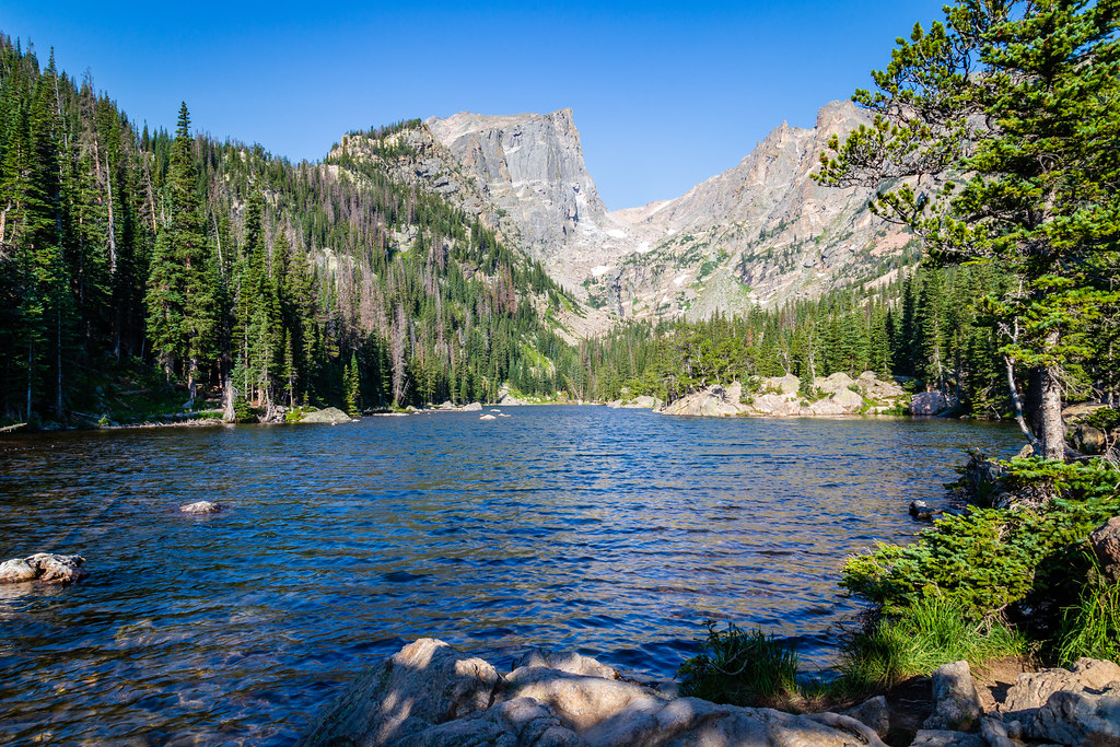
Photo: aparlette via Flickr (CC BY 2.0)
Rocky Mountain National Park remains open in winter, but snow transforms how visitors move through it. Trail Ridge Road no longer connects Estes Park with Grand Lake, many trails require traction or snowshoes, and afternoon weather can erase morning tracks within minutes. In return, visitors find quiet lakes, snow-covered peaks, active wildlife at lower elevations, and far fewer vehicles than during summer.
Most first-time winter trips work best from the east side near Estes Park. Bear Lake Road provides access to several dependable snowshoeing routes, while lower valleys such as Moraine Park and Horseshoe Park offer easier walking and wildlife viewing. The west side near Grand Lake receives deeper snow and supports excellent cross-country skiing, but the seasonal road closure across the Continental Divide separates the two entrances.
What to Expect in Rocky Mountain National Park in Winter
Elevation controls almost every winter decision. Park roads begin around 7,500 feet, Bear Lake sits at 9,475 feet, and surrounding summits rise above 12,000 feet. A dry morning in Estes Park can coincide with blowing snow and dangerous wind chill near the Continental Divide. Temperatures commonly drop below freezing overnight, while exposed alpine terrain may experience winds strong enough to obscure tracks and destabilize hikers.
Snow depth varies sharply by elevation and location
Lower eastern valleys often have patchy snow because powerful downslope winds strip exposed slopes. Bear Lake and the subalpine forest usually hold continuous snow, with packed surfaces on popular routes. The west side receives more moisture from Pacific weather systems, so forests near Grand Lake generally develop a deeper, softer snowpack suited to skis and snowshoes. Fresh storms can add substantial accumulation at higher elevations while leaving Estes Park comparatively dry.
Winter changes the park’s ecology
Elk descend from high summer ranges into Moraine Park, Horseshoe Park, and neighboring valleys, where wind exposes grasses. Mule deer also concentrate at lower elevations. Snowshoe hares, pine squirrels, and American martens remain active in subalpine forest, while white-tailed ptarmigan use feathered feet and seasonal plumage to survive near treeline. Visitors should scan open meadows from established pullouts and give animals enough space to feed without raising their heads or changing direction.
The landscape feels larger and quieter
On the climb from Bear Lake toward Dream Lake, packed snow muffles footsteps beneath Engelmann spruce and subalpine fir. The trail rises steadily, cold air settles beside Nymph Lake, and gusts become audible in the canopy before reaching the ground. At Dream Lake, the forest opens abruptly beneath 12,713-foot Hallett Peak. Wind often drives loose crystals across the frozen surface, and exposed skin cools much faster than it did among the trees.
Winter Roads, Entrances, and Trail Access in Rocky Mountain National Park
Rocky Mountain National Park covers both sides of the Continental Divide, but winter effectively creates two separate destinations. Trail Ridge Road, the highway that climbs to 12,183 feet, closes through the high country after sustained autumn snow. Driving between Estes Park and Grand Lake then requires a long route around the mountains rather than a direct crossing through the park.
East-side access from Estes Park
Bear Lake Road is the principal winter recreation corridor. It climbs from Moraine Park to trailheads for Sprague Lake, Bierstadt Lake, Glacier Gorge, and Bear Lake. Snowplows generally prioritize major paved roads, although storms, wind, ice, and limited parking can disrupt access. Other east-side roads lead toward Wild Basin, Longs Peak, and the Fall River entrance, but winter maintenance and final trailhead access vary.
Parking and seasonal operations
Winter visitors should expect fewer transportation services than in peak summer. An entrance pass is generally required year-round, while timed-entry systems are usually associated with busier seasons rather than the core winter months. Road status, fees, reservations, shuttle operations, and temporary trail restrictions can change, so confirm current details on the official park site before leaving Estes Park or Grand Lake.
West-side access from Grand Lake
The Kawuneeche Valley offers broad meadows, lodgepole pine forest, and access to the Colorado River headwaters. Winter snow is often deeper here than on the east side. Cross-country skiers use suitable sections of the valley trails and the closed road corridor, while snowshoers explore routes toward Adams Falls and nearby forest. Moose are frequently associated with willow habitat, but they require wide clearance because deep snow can make encounters difficult to avoid.
How trail conditions affect distance
Winter mileage demands more time than the same route in summer. Packed snow may support ordinary hiking boots with traction devices, while unconsolidated snow can require snowshoes and double the effort. Wind can refill tracks within hours. Our team recommends choosing a turnaround time before departure rather than treating a lake or overlook as mandatory.
- Carry traction devices for packed and icy trails, even when snowshoes are also in the vehicle.
- Bring snowshoes after fresh snowfall or when traveling beyond heavily used routes.
- Use waterproof boots, gaiters, insulated gloves, and a wind-resistant outer layer.
- Pack a paper map, headlamp, food, water, and emergency insulation.
- Avoid walking onto frozen lakes unless official guidance and observed conditions support it.
Choosing When to Visit Rocky Mountain National Park in Winter
Winter conditions develop gradually and retreat unevenly. November can combine dry lower trails with severe alpine weather, while March often brings the deepest snowpack and stronger sunshine. April and May belong to the spring calendar, but high trails remain wintry long after roads and valleys begin to thaw. The following comparison shows how those differences affect a visit.
| Period | Typical conditions | Crowd pattern | Road and trail access | Best uses |
|---|---|---|---|---|
| November to mid-December | Variable snow, short days, frequent ice | Generally light outside holiday periods | High road closed, lower trails may alternate between dirt, ice, and snow | Wildlife viewing, short hikes, early-season snowshoeing |
| Late December to February | Persistent subalpine snow, cold nights, strong winds | Busy around holidays and fair-weather weekends | Reliable winter routes near Bear Lake and on the west side | Snowshoeing, skiing, sledding, frozen-lake scenery |
| March | Deep snowpack, longer daylight, rapid weather changes | Moderate, especially during school breaks | Good snow travel, with increasing afternoon softening | Longer snowshoe trips and cross-country skiing |
| April to May | Lower-elevation thaw, mud, ice, and lingering mountain snow | Light to moderate | Trails can shift from dry ground to deep snow within one climb | Valley walks, wildlife watching, flexible mixed-condition hikes |
| June to October | Summer access followed by autumn cooling and snowfall | Highest in summer, easing after September | Broader road and trail access when weather permits | Alpine hiking, scenic drives, wildflowers, fall color |
When quieter conditions matter most
January and February weekdays usually provide the strongest combination of established snow and reduced traffic. Quiet does not guarantee empty trailheads, especially at Bear Lake after a clear forecast. Arriving early improves parking options and gives visitors more daylight for slow travel. Holiday weeks and sunny weekends concentrate people on the Bear Lake, Dream Lake, and Emerald Lake corridor, while longer routes from Glacier Gorge often thin out sooner.
When longer days are the priority
March suits visitors who want additional daylight without surrendering the winter landscape. Stronger sun softens exposed snow by afternoon, then overnight cooling creates hard, slick surfaces. Start longer routes early, carry traction, and expect changing footing during the return. Spring conditions become increasingly complex in April because bare trail near a valley floor can lead to deep snow several hundred feet higher.
What to Do in Rocky Mountain National Park Based on Your Experience
Route selection should account for navigation, snow depth, avalanche exposure, and the slow pace of winter travel. Familiar summer paths can disappear beneath drifting snow, particularly above treeline and around open lakes. Beginners generally fare better on forested routes where frequent traffic creates a visible track. Experienced visitors can travel farther, but they still need conservative turnaround times and the ability to navigate when snowfall covers footprints and trail signs.
Short walks and first snowshoe trips
The 0.8-mile Sprague Lake loop has limited elevation gain and broad views toward the Continental Divide. Packed snow frequently makes traction devices more useful than snowshoes. The route from Bear Lake to Nymph Lake covers roughly one mile round trip and climbs through sheltered forest, although continuing toward Dream Lake adds steeper grades and greater wind exposure. On the west side, the short Adams Falls route begins near Grand Lake and can become icy where packed snow refreezes.
Longer routes for prepared visitors
Emerald Lake is approximately 3.6 miles round trip from Bear Lake, passing Nymph and Dream lakes before reaching a basin beneath Flattop Mountain and Hallett Peak. Mills Lake requires roughly 5.5 miles round trip from the Glacier Gorge area. Both routes demand additional time after storms. Snow can obscure junctions, and wind near the lakes may produce severe wind chill even when the trailhead feels comfortable.
Avalanche terrain requires separate judgment
A packed trail does not establish that surrounding slopes are stable. Routes extending toward The Loch, Lake Haiyaha, Flattop Mountain, and steeper backcountry basins can enter or pass below avalanche terrain. Check the regional avalanche forecast, identify slope angles and runout zones, and carry rescue equipment when entering consequential terrain. Visitors without avalanche training should choose low-angle forest routes or join a winter outing led by a qualified guide.
How Crowds Affect Rocky Mountain National Park in Winter
Winter crowding is concentrated rather than widespread. Bear Lake can fill quickly on clear weekends because several major routes share one trailhead. A busy trail creates a firm walking surface, but it also produces polished ice on inclines and deep holes where hikers step beside the packed track. Sprague Lake and lower valley pullouts absorb some overflow, while remote west-side routes may remain quiet enough that visitors must break trail themselves.
Parking affects the route you can complete
A late arrival can add walking distance or force a change of trailhead, reducing the daylight available for the intended route. Keep two alternatives in the same corridor, such as pairing Emerald Lake as the primary objective with Sprague Lake as the shorter backup. Never park outside designated spaces or obstruct snow-removal equipment. Winter storms narrow shoulders and reduce room for emergency vehicles.
Solitude brings additional responsibility
On lightly traveled routes, help may be hours away and cellular coverage remains inconsistent. Leave a trip plan with someone outside the hiking party, including the trailhead, destination, vehicle description, and expected return time. Groups should also carry enough equipment to remain warm if an injury stops movement. A reflective emergency blanket alone provides little insulation against snow, so include a foam pad or insulated sitting layer.
Reservations, Permits, and Seasonal Planning
Most winter day outings require less advance scheduling than summer visits, but overnight wilderness travel requires a permit and campsite-specific planning. Winter camping introduces deep-snow sanitation rules, cold-related equipment demands, and restrictions designed to protect vegetation beneath shallow snow. Anyone considering an overnight trip should review the park’s wilderness camping system before selecting a route rather than assuming a summer campsite will be practical.
Plan early for a summer alternative
Visitors comparing winter with June through October should account for timed-entry periods, heavier traffic, and competitive wilderness permits. Reservation windows may open months before travel, so decide early if Trail Ridge Road, alpine tundra hiking, or summer wildflowers are central priorities. Winter offers simpler day-trip logistics, while summer provides access to destinations such as the Alpine Visitor Center area and higher sections of the Continental Divide.
Use priorities to choose your season
- Choose January or February for dependable snow at subalpine elevations, short snowshoe routes, and lighter weekday traffic.
- Choose March for deeper snow, longer daylight, and extended ski or snowshoe outings.
- Choose late spring for wildlife viewing and lower-valley walking, with traction and snowshoes available for higher trails.
- Choose summer for the broadest road access, alpine hiking, and routes that cross the Continental Divide.
- Choose September for cooler hiking weather, elk activity, and fewer visitors than during midsummer, while accepting the possibility of early snow.
Planning a Successful Winter Visit to Rocky Mountain National Park
Rocky Mountain National Park rewards a flexible winter plan. Select a route based on current snow, wind, and visibility rather than mileage alone. Start with a lower-elevation option and a subalpine alternative, then make the final choice at the trailhead. Sprague Lake, Moraine Park, and the Bear Lake corridor provide useful options of different lengths without requiring travel across the closed high section of Trail Ridge Road.
The best period depends on the experience you value. Midwinter provides established snow and quieter weekdays, March adds daylight, and late spring favors mixed hiking and wildlife observation. Build extra time into every route, carry both traction and flotation when conditions are uncertain, and turn around before fatigue or weather removes that margin. Those decisions make winter travel safer while preserving the silence, scale, and close view of mountain weather that define the season.
Want to keep exploring? Browse all our Rocky Mountain guides and articles for more trip-planning tips and ideas.
Gear & Essentials
Tell us about your trip and we will add what else you will want:
The basics
Worth having in the car whatever the park.
For this trip
Traveling with kids
Bringing a pet
RVing
Backcountry
Winter conditions
On the water
Photography
Accessibility
As an Amazon Associate we earn from qualifying purchases, at no extra cost to you.