7 Best Summer Hikes in Yellowstone National Park
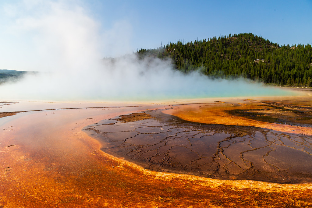
Photo: aparlette via Flickr (CC BY 2.0)
Our Best Summer Hikes Yellowstone guide begins with a practical reality: elevation determines when many of the park’s strongest trails become safely walkable. Yellowstone’s roads cross plateaus near 8,000 feet, while routes such as Avalanche Peak and Mount Washburn climb above 10,000 feet. Snowfields, saturated ground, thunderstorms, wildfire smoke, and temporary wildlife closures can all affect a summer itinerary.
We selected seven hikes that represent Yellowstone’s defining landscapes, including hydrothermal basins, subalpine forests, high summits, waterfalls, Yellowstone Lake shoreline, and wildlife habitat. The routes range from a mostly level 4.8-mile geyser walk to a steep climb gaining roughly 2,100 feet in 2.3 miles.
Planning Your 7 Best Summer Hikes in Yellowstone National Park
Yellowstone covers more than 2.2 million acres, and its figure-eight Grand Loop Road links trailheads spread across several watersheds. Driving between Old Faithful and the Mount Washburn area commonly takes about 90 minutes without a substantial wildlife or traffic delay. Group hikes by region rather than crossing the park repeatedly.
Elevation sets the hiking calendar
Lower and sunnier routes often dry first. Storm Point, at roughly 7,700 feet beside Yellowstone Lake, can become viable while snow still blocks high ridges. Mount Washburn reaches 10,219 feet, Avalanche Peak reaches 10,568 feet, and both can retain snow into early summer. Late June through September generally provides the broadest selection, although annual snowpack changes the precise timing.
Road access shapes the day
Most trailheads in our selection depend on seasonal park roads. Dunraven Pass provides access to the standard Mount Washburn route, while Avalanche Peak begins along the East Entrance Road near Sylvan Pass. Winter road closures and spring plowing make these poor choices for fixed, early-season plans. Check road openings, trail closures, entrance requirements, backcountry permit rules, and current fees on the official park site before departure.
- Base Old Faithful area hikes together, including Fairy Falls and Lone Star Geyser.
- Combine Storm Point or Avalanche Peak with a Yellowstone Lake day.
- Pair Mount Washburn with Canyon Village and the Grand Canyon of the Yellowstone.
- Allow extra driving time where bison commonly slow traffic, especially in Hayden Valley.
Seasonal Context for the Best Summer Hikes Yellowstone Has to Offer
Calendar summer does not produce uniform trail conditions. June can feel like spring at high elevations, July usually brings the most reliable access, and September introduces freezing nights and occasional snow. Afternoon thunderstorms are common during warmer periods, which makes summit timing a safety decision rather than a simple preference.
How Yellowstone’s seasons compare
| Season | Typical trail conditions | Crowd effects | Road and activity access |
|---|---|---|---|
| Spring, April through May | Snow, mud, swollen creeks, and lingering ice | Light visitation, but fewer usable trails | Roads reopen in stages; lower walks and wildlife viewing dominate |
| Early summer, June | Drying low routes, snowfields at elevation, active mosquitoes | Increasing traffic and busy thermal basins | Most major corridors generally open, but high trails may lag |
| High summer, July through August | Broad access, warm afternoons, thunderstorms, possible smoke | Full trailhead lots and slower park drives | Best overall selection of high and low hikes |
| Early fall, September | Cool mornings, fewer insects, possible early snow | Noticeably lighter after peak vacation weeks | Excellent hiking until weather closes exposed routes |
| Winter, November through March | Deep snow and severe cold | Low visitation outside developed winter hubs | Most roads close to regular vehicles; skiing and snowshoeing replace hiking |
What peak crowds change on the ground
Congestion matters most at small trailhead lots and popular thermal areas. At Fairy Falls, vehicles may queue near the Grand Prismatic Spring access area, while wildlife jams can consume an hour elsewhere in the park. Starting around sunrise improves parking odds, reduces heat exposure, and places exposed summit hikers below tree line before the usual afternoon storm cycle.
Trail congestion drops quickly beyond boardwalks and roadside overlooks. Lone Star Geyser’s old road spreads walkers over a wide corridor, and Avalanche Peak’s steep grade limits casual traffic. Mount Washburn remains popular because its broad trail and fire lookout create an accessible high-country objective, so expect company even when starting early.
Matching the Best Summer Hikes Yellowstone Offers to Your Priorities
The seven routes differ more in exposure and physical demand than their mileages suggest. Storm Point is short and mostly gentle, while Avalanche Peak compresses substantial climbing into less than five miles. Fairy Falls and Lone Star Geyser suit hikers who prefer modest grades, but both have limited shelter during storms.
The 7 Best Summer Hikes in Yellowstone National Park at a Glance
| Hike | Approximate distance | Defining feature | Difficulty |
|---|---|---|---|
| Mount Washburn from Dunraven Pass | 6.4 miles round trip | 10,219-foot summit and broad volcanic plateau views | Moderate to strenuous |
| Avalanche Peak | 4.6 miles round trip | Steep ascent above Yellowstone Lake | Strenuous |
| Fairy Falls with Grand Prismatic overlook | About 5.4 miles round trip | Thermal basin panorama and 197-foot waterfall | Moderate |
| Lone Star Geyser | 4.8 miles round trip | Backcountry geyser cone beside the Firehole River | Easy to moderate |
| Bunsen Peak | 4.6 miles round trip | Gallatin Range and northern plateau views | Moderate |
| Mystic Falls and overlook loop | About 3.5 miles | Waterfall, thermal basin, and elevated overlook | Moderate |
| Storm Point | 2.3 miles round trip | Yellowstone Lake shoreline and open sage habitat | Easy |
A simple decision framework
Choose Mount Washburn for a first Yellowstone summit, Avalanche Peak for maximum effort, and Storm Point for a shorter family walk. Fairy Falls provides the strongest pairing of hydrothermal scenery and a waterfall. Lone Star Geyser offers a quieter geothermal experience, while Bunsen Peak and Mystic Falls work well from the northern and western portions of the Grand Loop.
- For panoramic views: Mount Washburn, Avalanche Peak, or Bunsen Peak.
- For geothermal features: Fairy Falls or Lone Star Geyser.
- For a short morning: Storm Point.
- For mixed scenery: Mystic Falls and its overlook loop.
- For avoiding exposed summits: Lone Star Geyser or Fairy Falls, while still watching for lightning.
Three high-priority hikes for a first summer visit
Our team would place Mount Washburn, Fairy Falls, and Storm Point near the top of a first visit because together they reveal three distinct parts of Yellowstone: the elevated volcanic plateau, the active caldera’s hydrothermal system, and the immense lake occupying its southeastern basin.
Mount Washburn from Dunraven Pass
Route, exposure, and summit experience
The trail follows a broad former vehicle road for approximately 3.2 miles to the summit. It gains about 1,400 feet through open slopes where bighorn sheep are sometimes seen. The lack of sustained forest cover means strong sun, wind, and lightning exposure. Snow can conceal sections near the upper switchbacks early in the season.
Near the summit, gravel shifts underfoot and the wind carries little of the forest sound from below. The fire lookout stands above a rounded ridge rather than a sharp alpine pinnacle. From the top, Yellowstone Lake, the Absaroka Range, and the Grand Canyon country occupy separate horizons, making the scale of the plateau easier to understand than it is from the road.
Fairy Falls and Grand Prismatic Spring overlook
Thermal landscape followed by lodgepole forest
This route crosses the Firehole River and climbs briefly to an overlook above Grand Prismatic Spring. The elevated angle reveals the spring’s blue center and orange microbial mats far better than the basin boardwalk does. The trail then continues through lodgepole pine forest to Fairy Falls, where water drops 197 feet over a cliff of volcanic rock. Remain on designated trails because thin thermal crust and scalding water occur throughout the basin.
Storm Point beside Yellowstone Lake
A short route with exposed shoreline weather
Storm Point loops through sagebrush, lodgepole forest, and rocky shoreline beside Yellowstone Lake, North America’s largest high-elevation lake above 7,000 feet. The modest distance makes it useful on arrival or departure days, but the open point receives abrupt wind and fast-moving storms. Bison commonly use the surrounding habitat, and hikers should give them at least 25 yards while avoiding any movement that blocks their route.
Four more trails that round out the list
The remaining routes cover a backcountry geyser, a northern summit, a waterfall loop, and an elevated thermal overlook. Their trailheads sit in different sections of the Grand Loop, so each fits a separate touring day. Lone Star Geyser and Mystic Falls pair naturally with the Old Faithful area, while Bunsen Peak belongs in a Mammoth Hot Springs itinerary.
Lone Star Geyser
Gentle grades and a long eruption cycle
An old paved service road follows the Firehole River for about 2.4 miles to Lone Star Geyser, a roughly 12-foot-high cone built from repeated mineral deposits. Major eruptions commonly occur about three hours apart and can continue for roughly 20 minutes, although intervals vary. Check the informal log near the geyser to estimate the previous eruption, then remain well away from the cone and runoff channels.
Bunsen Peak
A northern summit above Swan Lake Flat
Bunsen Peak rises to 8,564 feet south of Mammoth Hot Springs. Switchbacks climb approximately 1,300 feet through forest and exposed slopes, eventually opening toward Electric Peak, the Gallatin Range, and the Gardner River canyon. The summit area offers little protection from wind or lightning. Begin early, carry more water than the moderate mileage suggests, and avoid lingering above tree line when clouds build.
Mystic Falls and the Biscuit Basin overlook
Waterfall spray followed by a steep climb
Mystic Falls drops about 70 feet where the Little Firehole River enters a narrow canyon. The direct trail is relatively gentle, but the overlook loop adds a sharp ascent on loose, sun-exposed ground. From the ridge, hikers can see Biscuit Basin, the Upper Geyser Basin, and steam columns rising across the Firehole Valley. Stay on the maintained route around thermal terrain, including near the trailhead.
Reservations, permits, and wildlife preparation
Ordinary day hikes on these seven routes generally do not require an individual hiking permit. Overnight travel into Yellowstone’s backcountry uses a separate permit system, and developed campgrounds and lodging follow their own reservation calendars. Summer inventory can disappear well before arrival, particularly around holiday periods. Release dates, entrance fees, trail closures, and campsite procedures can change, so confirm current details on the official park site before committing to transportation or lodging.
Build the itinerary before booking a base
Choose accommodations according to the trails you value most. Staying near Old Faithful reduces driving for Fairy Falls, Lone Star Geyser, and Mystic Falls. Canyon is better positioned for Mount Washburn, while the lake area supports Storm Point and Avalanche Peak. A single base simplifies unpacking but can add several hours of driving across a three-day hiking plan.
| Planning base | Best matched hikes | Primary advantage |
|---|---|---|
| Old Faithful area | Fairy Falls, Lone Star Geyser, Mystic Falls | Three trailheads within the Firehole region |
| Canyon area | Mount Washburn | Early access to Dunraven Pass |
| Lake area | Storm Point, Avalanche Peak | Shorter approach to eastern trailheads |
| Mammoth area | Bunsen Peak | Convenient northern-loop start |
Carry bear spray correctly
Hikers should carry EPA-approved bear spray where it can be reached immediately, rather than buried in a pack. Travel in groups when possible, make conversational noise around blind bends, and keep at least 100 yards from bears and wolves. Never run from a bear. Bison, elk, and other large animals require at least 25 yards of separation, with additional distance whenever behavior changes in response to your presence.
- Carry bear spray in a belt or chest holster and understand how to remove the safety clip.
- Pack insulating and waterproof layers, even on a warm morning.
- Bring a paper map because mobile coverage is unreliable.
- Store food, scented items, and refuse securely.
- Turn around if lightning, smoke, snow, or wildlife blocks safe passage.
Choosing the right part of summer
Late July and August provide the highest probability that all seven trails will be free of persistent snow, but they also bring the heaviest road traffic and the greatest chance of afternoon thunderstorms. June favors waterfalls and green meadows, though mosquitoes, mud, and snowfields can complicate higher routes. September usually delivers cool hiking temperatures and lighter crowds, balanced against shorter daylight and possible snow at Dunraven or Sylvan passes.
Match the month to your main objective
Plan a late-season visit if Avalanche Peak and Mount Washburn are essential. Choose June for Fairy Falls, Lone Star Geyser, and Storm Point while retaining backup walks at lower elevations. September works particularly well for Bunsen Peak and Mystic Falls on stable days. In every month, start exposed climbs early and keep a lower, forested alternative available when the forecast deteriorates.
A practical three-day sequence
- Day one: Hike Fairy Falls early, then choose Mystic Falls or Lone Star Geyser according to available time and energy.
- Day two: Climb Mount Washburn before midday and visit Canyon overlooks afterward.
- Day three: Select Storm Point for an easier lake day or Avalanche Peak for a strenuous finish.
This sequence limits repeated driving and places the most exposed routes in the morning. Bunsen Peak can replace Mount Washburn when northern-loop access is more convenient, while Lone Star Geyser serves as a useful substitute when smoke or thunderstorms make summit travel unwise.
Final Planning Advice for the Best Summer Hikes in Yellowstone
The Best Summer Hikes Yellowstone visitors can choose depend on elevation, road access, weather, and daily driving tolerance. Mount Washburn and Avalanche Peak reward stable high-country conditions. Fairy Falls, Lone Star Geyser, and Mystic Falls concentrate geothermal and waterfall scenery near the Firehole River, while Storm Point and Bunsen Peak provide efficient options from the lake and northern regions.
Select one priority hike for each day, start before parking and thunderstorms become limiting factors, and keep a lower-elevation substitute ready. That approach leaves room for wildlife delays, changing trail conditions, and the distances between Yellowstone’s regions while still covering the landscapes that make these seven routes distinctive.
Want to keep exploring? Browse all our Yellowstone guides and articles for more trip-planning tips and ideas.
Gear & Essentials
Tell us about your trip and we will add what else you will want:
The basics
Worth having in the car whatever the park.
For this trip
Traveling with kids
Bringing a pet
RVing
Backcountry
On the water
Photography
Accessibility
As an Amazon Associate we earn from qualifying purchases, at no extra cost to you.