5 Best Hikes in Zion National Park
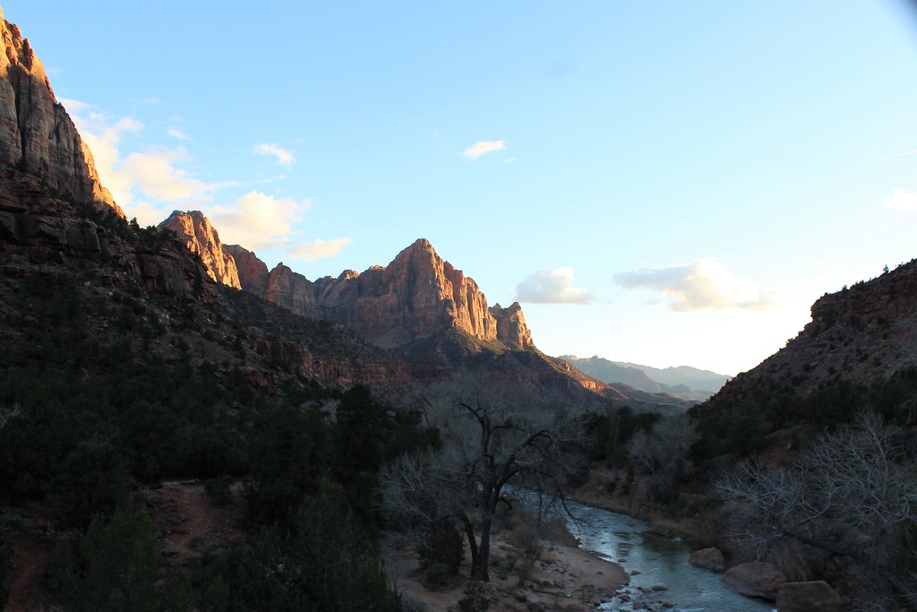
Photo: agcaddesigns.com Architectural Renderings via Flickr (CC BY 2.0)
Our Best Hikes Zion National Park guide narrows a complex trail system to five routes that reveal the park’s sandstone cliffs, river narrows, high viewpoints, and quieter desert benches. Zion Canyon contains the most famous trailheads, but two of our choices begin outside the canyon’s shuttle corridor, giving visitors useful alternatives when the central valley is crowded.
The five hikes range from a one mile overlook walk to a strenuous river journey and an exposed summit route. Below, our team compares their distances, terrain, access, and major hazards before examining each trail in detail. Distances are approximate because river travel, turnaround choices, and temporary access changes can affect the final mileage.
How Zion’s landscape shapes every hike
Zion National Park occupies the transition between the Colorado Plateau, Great Basin, and Mojave Desert. Elevations range from roughly 3,700 feet along the Virgin River near Springdale to 8,726 feet on Horse Ranch Mountain. That vertical range creates striking ecological changes. Cottonwoods and box elders line the river, pinyon and juniper cover middle elevation benches, and ponderosa pine grows across the higher plateaus.
Navajo Sandstone cliffs and narrow canyons
Most of Zion Canyon is carved into Navajo Sandstone, an approximately 180 million year old formation created from ancient sand dunes. Cross bedding remains visible in the pale cliffs, particularly along the Zion Mount Carmel Highway. The Virgin River cuts downward through this rock while flash floods scour side canyons, producing constricted passages such as The Narrows and the hanging valleys seen from Angels Landing.
Three distinct hiking environments
The best route depends partly on the experience you want. Angels Landing combines constructed switchbacks, a high saddle, and an exposed sandstone ridge. The Narrows replaces a conventional path with the Virgin River itself. Observation Point reaches a higher rim perspective through the East Mesa, while Canyon Overlook and the Watchman Trail deliver shorter views without committing an entire day.
The 5 Best Hikes in Zion National Park at a Glance
These five trails cover Zion’s defining experiences while remaining realistic for a typical park visit. Mileage alone can be misleading. River current makes The Narrows tiring, summer heat raises the difficulty of the Watchman Trail, and the final Angels Landing ridge demands comfort with exposure.
| Hike | Approximate distance | Elevation gain | Typical difficulty | Defining feature |
|---|---|---|---|---|
| Angels Landing | 5.4 miles round trip | 1,488 feet | Strenuous | Exposed summit ridge |
| The Narrows, bottom up | Up to about 9.4 miles round trip | Gradual | Moderate to strenuous | Hiking through the Virgin River |
| Observation Point via East Mesa | About 7 miles round trip | About 700 feet | Moderate | High view over Zion Canyon |
| Canyon Overlook Trail | 1 mile round trip | About 160 feet | Easy to moderate | Lower Pine Creek Canyon view |
| Watchman Trail | 3.3 miles round trip | About 370 feet | Moderate | Springdale and lower canyon panorama |
How We Selected the Best Hikes Zion National Park Has to Offer
Our list prioritizes distinct scenery rather than five variations on the same canyon viewpoint. It also includes different effort levels and access zones. Experienced hikers can pair Angels Landing with The Narrows across two days, while families and visitors with limited time can combine Canyon Overlook and the Watchman Trail without entering deep into Zion Canyon.
Logistics for the Best Hikes Zion National Park visitors should know
Zion Canyon Scenic Drive is the access corridor for Angels Landing and The Narrows. For much of the busy season, visitors generally reach trailheads there using the park shuttle rather than a private vehicle. Observation Point via East Mesa begins outside the main canyon, Canyon Overlook sits along the Zion Mount Carmel Highway, and the Watchman Trail starts near the park’s south entrance.
Permits, transport, and trailhead planning
A permit is required for the chain assisted section leading from Scout Lookout to Angels Landing. Hikers may reach Scout Lookout on the West Rim Trail without entering that permitted section, subject to current park rules. Shuttle operations, permit procedures, entrance fees, parking restrictions, trail closures, and river conditions can change, so confirm current details on the official park site before fixing an itinerary.
Seasonal conditions affect route choice
Spring runoff can close The Narrows when the Virgin River is running too high, while summer thunderstorms introduce flash flood danger even when the trail is open. July and August afternoons are especially storm prone. Summer heat is a greater concern on exposed routes such as Watchman and East Mesa. Autumn usually brings cooler hiking temperatures, while winter can leave ice on Walter’s Wiggles, shaded ledges, and higher elevation access roads.
What to carry for Zion’s varied terrain
Water needs vary with temperature and route, but dry air and direct sun accelerate dehydration. River hiking requires footwear that remains secure on rounded, unstable rocks. For the five routes in this guide, our team would pack:
- At least two to three liters of water per person for longer dry trails, with more during hot weather
- Salty food and compact snacks that can be eaten without a long stop
- Sun protection, including a brimmed hat and sunscreen
- A paper or downloaded map because cellular coverage is inconsistent
- Trekking poles or a sturdy river staff for The Narrows
- Warm layers for shaded canyons, winter mornings, and sudden temperature changes
Turn around when weather, heat, footing, or exposure exceeds your ability. Zion’s steep terrain leaves little room for errors near cliff edges. Our report on a visitor fatality at Zion National Park also underscores why barriers, closures, and posted warnings should be treated as safety controls rather than suggestions.
Exploring the 5 Best Hikes in Zion National Park
The first two hikes define Zion for many visitors, yet they require different skills. Angels Landing tests tolerance for height and sustained climbing. The Narrows demands balance, cold water management, and careful attention to weather occurring far upstream.
1. Angels Landing via the West Rim Trail
The route begins at the Grotto and crosses the Virgin River before climbing the West Rim Trail. Long switchbacks rise above Refrigerator Canyon, followed by Walter’s Wiggles, a compact series of turns built into the cliff. Scout Lookout provides a broad canyon view and a sensible turnaround for anyone uncomfortable with the exposed final ridge.
The permitted chain section
Beyond Scout Lookout, the route follows a narrow sandstone spine with chains assisting hikers across steep, polished sections. Drop offs are severe, passing can require patience, and wet rock substantially reduces traction. The summit, at about 5,790 feet, overlooks the Great White Throne, Big Bend, and the Virgin River far below. Allow roughly four hours, adding time for shuttle travel and congestion along the ridge.
2. The Narrows from the Temple of Sinawava
The bottom up route begins with the paved Riverside Walk, which follows the Virgin River for about one mile. After the pavement ends, hikers enter the water and travel upstream toward Mystery Canyon, Orderville Canyon, and Wall Street. There is no single required turnaround point, although day hikers cannot continue beyond Big Spring. Progress is much slower than normal trail walking.
What river hiking actually feels like
Inside Wall Street, cool water presses against your shins or thighs while rounded stones shift beneath each step. The canyon walls rise close overhead, muting direct sun and amplifying splashes and voices. Forward movement becomes deliberate because the riverbed is difficult to see through moving water. The confined scale explains both the route’s appeal and its flash flood risk: higher ground can be scarce when the sandstone walls tighten around the channel.
Three viewpoints beyond the main canyon floor
The remaining hikes shift east and south, where access, vegetation, and sightlines differ from the Zion Canyon corridor. Observation Point reaches the rim above Angels Landing, Canyon Overlook reveals the park’s slickrock country, and the Watchman Trail climbs through lower elevation desert near Springdale. Together, they provide practical alternatives when water conditions, permits, or exposure rule out the first two routes.
3. Observation Point via East Mesa
Observation Point stands at approximately 6,507 feet, roughly 700 feet above Angels Landing. From the rim, hikers look south through Zion Canyon toward Mount Baldy, with Angels Landing appearing below the viewpoint. The East Mesa approach crosses ponderosa and pinyon forest before reaching open sandstone near the rim, avoiding the steep ascent formerly used from Weeping Rock.
Reaching the East Mesa trailhead
The trailhead lies beyond the park’s east entrance on roads that can become deeply rutted or muddy after rain and snow. Low clearance vehicles may need to stop short, adding road walking to the day. Local seasonal transport services sometimes operate from the Zion Ponderosa area. Because much of the approach is gently graded, save energy for the return and keep children close once the trail reaches unfenced rim terrain.
4. Canyon Overlook Trail
Canyon Overlook begins immediately east of the Zion Mount Carmel Tunnel. The path traverses ledges above Pine Creek Canyon, passes beneath a sandstone alcove, and ends opposite the East Temple. Railings protect several exposed sections, but sand on rock and abrupt drop offs still require attention. Limited roadside parking makes an early start valuable, particularly during mild spring and autumn weekends.
Reading the landscape from the overlook
The viewpoint faces the Great Arch of Zion, a vast recessed formation carved into Navajo Sandstone rather than a freestanding arch. Below, the Zion Mount Carmel Highway descends through switchbacks toward Zion Canyon. Look for the tunnel’s gallery windows cut into the cliff. These openings provided light and ventilation when the 1.1 mile tunnel was completed in 1930.
5. Watchman Trail
The Watchman Trail begins near the visitor center and climbs benches above the Virgin River without entering the shuttle corridor. The route ends at a loop overlooking Springdale, lower Zion Canyon, and the Towers of the Virgin. Its namesake peak, the Watchman, rises to 6,545 feet across the valley, although the trail does not climb the mountain itself.
Managing sun on the lower benches
Most of the climb crosses open terrain with sparse shade. Start near sunrise during warm months, carry more water than the modest mileage might suggest, and avoid treating the overlook as a sunset route unless everyone has a headlamp for the descent. Loose sand can reduce traction on corners. Desert bighorn sheep occasionally use nearby slopes, so scan rocky benches without approaching or blocking an animal’s path.
Match each trail to weather and ability
The Best Hikes Zion National Park visitors choose should reflect the day’s limiting factor. High river flow can remove The Narrows from consideration, while ice can make Angels Landing and Canyon Overlook hazardous. Observation Point offers cooler conditions at higher elevation, although snow or mud may complicate East Mesa access. Watchman is most comfortable during cooler mornings because its lower desert benches absorb substantial afternoon heat.
A practical trail selection guide
| Condition or priority | Best match | Main reason |
|---|---|---|
| Half day with no summit permit | Scout Lookout | Uses the West Rim climb without entering the chain section |
| Cool morning and limited time | Canyon Overlook | Short route with a major east side viewpoint |
| Discomfort with severe exposure | Watchman Trail | Broad canyon scenery without a narrow summit ridge |
| Clear forecast and safe river flow | The Narrows | Provides Zion’s defining slot canyon experience |
| Full day and reliable east side access | Observation Point | Reaches the highest viewpoint among these five hikes |
Plan around Zion’s separate corridors
Pair trails by geography rather than driving repeatedly across the park. Angels Landing and The Narrows fit naturally into separate days based in Zion Canyon. Canyon Overlook and Observation Point can share an east side day, provided the East Mesa road is passable. Watchman works well on an arrival morning or departure day because its trailhead is close to the south entrance.
- Reserve the clearest forecast window for Angels Landing or Observation Point.
- Place The Narrows only after checking upstream weather and river information.
- Hike Watchman early, then use the hotter afternoon for scenic driving or indoor breaks.
- Avoid combining two strenuous routes merely because their trailheads share a corridor.
Leave room for Zion’s quieter details
Fast itineraries often overlook the transitions between Zion’s major formations. Along East Mesa, notice how ponderosa pine replaces lower elevation cactus and yucca. Near Watchman, cryptobiotic soil forms dark, knobby crusts between plants. This living community of cyanobacteria, fungi, lichens, and mosses stabilizes desert soil, so remain on the established path rather than stepping around other hikers.
Wildlife and low impact travel
California condors may appear above high cliffs, identifiable by broad wings and long, steady glides. Mule deer commonly feed near the Virgin River, while canyon wrens produce descending whistles from sandstone walls. Store food securely, give wildlife space, and pack out fruit peels and snack fragments. In The Narrows, manage human waste according to current park guidance because the river corridor offers little suitable soil.
Choose your Zion hike with confidence
These five routes cover Zion’s essential terrain: the exposed ridge of Angels Landing, the river channel of The Narrows, the high rim at Observation Point, the sculpted east side seen from Canyon Overlook, and the desert benches below the Watchman. Selecting among them requires an honest assessment of exposure tolerance, footing, heat, river conditions, and available time.
Build the day around the hardest logistical constraint first, such as an Angels Landing permit, safe river flow, or East Mesa road access. Then add a shorter route only if daylight and energy remain. That approach produces a safer itinerary while preserving enough time to notice the geology, changing plant communities, and canyon scale that make each of Zion’s five best hikes distinct.
Want to keep exploring? Browse all our Zion guides and articles for more trip-planning tips and ideas.
Gear & Essentials
Tell us about your trip and we will add what else you will want:
The basics
Worth having in the car whatever the park.
For this trip
Traveling with kids
Bringing a pet
RVing
Backcountry
Winter conditions
On the water
Photography
Accessibility
As an Amazon Associate we earn from qualifying purchases, at no extra cost to you.