Grand Canyon National Park in Fall: What to Expect and What to Do
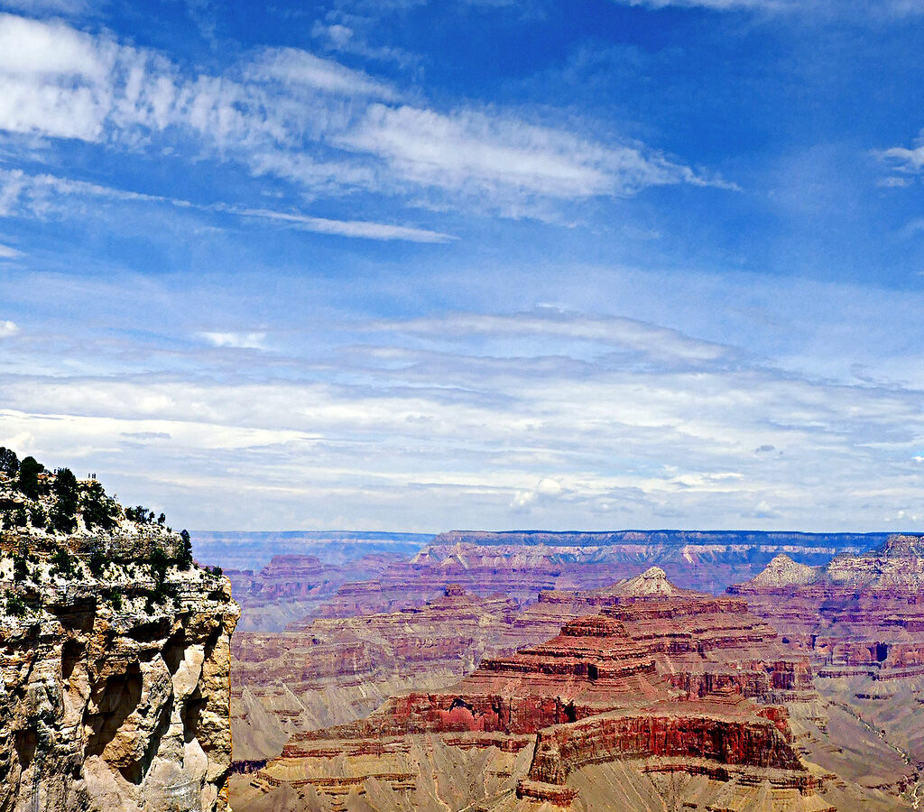
Photo: pom'. via Flickr (CC BY-SA 2.0)
Grand Canyon National Park can deliver summer heat, freezing nights, fall color, and snow during the same autumn trip. Elevation creates those contrasts. The Colorado River lies near 2,400 feet, the South Rim averages about 7,000 feet, and parts of the North Rim exceed 8,000 feet. A mild afternoon at a rim overlook can therefore coincide with dangerous heat deep in the canyon or ice on a shaded upper trail.
Fall generally brings clearer air, cooler hiking conditions, and fewer visitors than midsummer, but timing determines what remains accessible. September still behaves like summer below the rim. October provides the best balance of moderate temperatures and open facilities. November brings quiet viewpoints and possible snow, while shortening daylight and overnight freezes change how visitors should hike, drive, and pack.
What to Expect at Grand Canyon National Park in Fall
The park consists of two developed rims separated by the canyon. Although they face each other across a gap of roughly 10 miles, driving between Grand Canyon Village on the South Rim and the North Rim requires about 210 miles. Fall access decisions must therefore be made before arrival. The South Rim stays open throughout the year, while the North Rim operates seasonally and becomes increasingly vulnerable to snow and service reductions as autumn advances.
Elevation controls the weather
Weather forecasts for the rim do not describe conditions along the Colorado River. In September, inner canyon temperatures can remain above 100°F even when South Rim mornings require a jacket. By late October, the river corridor becomes more comfortable for hiking, but upper trail sections may be cold before sunrise. In November, snow can accumulate around the rims while lower reaches remain dry and comparatively warm.
Temperature also changes quickly during descents. The air generally warms as hikers lose elevation, while the return climb leads back into colder and windier conditions. Pack for the entire elevation range rather than the trailhead forecast. A sun hat, insulating layer, rain shell, gloves, and traction appropriate to the latest trail report can all belong in the same autumn day pack.
The two rims have different fall calendars
The South Rim provides the most dependable autumn base, with access from Williams and Flagstaff through Arizona highways. Desert View Drive runs east toward the park entrance near Cameron, passing overlooks such as Grandview Point, Moran Point, Lipan Point, and Desert View. Road distances inside the park are significant, so visitors should group nearby overlooks rather than repeatedly crossing the developed corridor.
The North Rim sits about 1,000 feet higher and receives substantially more snow. Its mixed conifer forest includes ponderosa pine, white fir, Douglas fir, spruce, and pockets of aspen. Aspen leaves commonly turn yellow from late September into October, although elevation, drought, wind, and early freezes alter the timing each year. Visitor services and road access become limited later in fall, and winter weather can close the approach.
How Grand Canyon National Park Changes Week by Week in Fall
There is no single set of “fall conditions” at the canyon. Early September resembles a quieter extension of summer, October is the main transition month, and November approaches winter at rim level. The following comparison reflects typical patterns rather than a forecast for a particular year.
| Period | Crowds | Typical conditions | Access | Best suited to |
|---|---|---|---|---|
| Early to mid September | Busy around major South Rim viewpoints, quieter after summer holidays | Warm rim afternoons, very hot inner canyon, possible thunderstorms | Broadest likelihood of both rims being accessible | Scenic driving, sunrise visits, short rim walks |
| Late September through mid October | Moderate, with congestion at sunset locations | Cool mornings, mild rim afternoons, improving inner canyon temperatures | South Rim fully practical, North Rim increasingly weather dependent | Day hiking, photography, fall color, rim cycling |
| Late October | Lower on weekdays, concentrated at major overlooks | Cold nights, possible rim snow, comfortable lower elevations | North Rim services may be reduced or finished for the season | Longer hikes, quieter viewpoints, clear night skies |
| November | Generally low outside holiday periods | Freezing rim nights, short days, possible ice and snow | South Rim remains the reliable choice | Solitude, winter photography, cautious rim and corridor hiking |
September retains summer conditions below the rim
September works well for travelers who want broad road access and long daylight, but it demands conservative hiking plans. Start below rim hikes before sunrise, turn around according to time and temperature, and avoid treating the descent as the easy half of the day. The return climb can take twice as long as the descent because every route ends with sustained elevation gain.
Short hikes are the safer introduction
On the South Kaibab Trail, Ooh Aah Point is about 1.8 miles round trip, while Cedar Ridge is approximately 3 miles round trip with around 1,100 feet of climbing on the return. The trail has broad views but little shade and no natural water. The Rim Trail provides a lower commitment alternative, with multiple access points between the village area and Hermits Rest.
October offers the broadest balance
October usually provides the most versatile conditions at Grand Canyon National Park. Rim temperatures support walking throughout much of the day, and the inner canyon begins losing its severe summer heat. Sunrise arrives later than in September, making early starts easier, while enough daylight remains for carefully planned hikes. Cold fronts can still bring strong winds, rain, or the first snow to exposed rim roads.
Stand at Yavapai Point after sunrise and the scale develops gradually. Limestone ledges catch the light first, darker shale slopes remain in shadow, and the Colorado River appears as a narrow segment far below. Gravel shifts underfoot along the rim path, wind moves through nearby pinyon and juniper, and the temperature can drop sharply whenever a cloud crosses the sun.
November rewards flexible plans
November visitors gain quieter trails and clearer sightlines, but daylight becomes a strict planning constraint. Shaded portions of Bright Angel Trail can hold ice near the rim after sunny areas have melted. Microspikes may be appropriate when current trail reports identify packed snow or ice. Hikers should carry a headlamp even on moderate outings because canyon walls create shade well before the published sunset.
Fall Crowds and Road Conditions at Grand Canyon National Park
Lower visitation does not guarantee empty overlooks. Mather Point, Yavapai Point, and the Grand Canyon Village historic district still concentrate visitors because they are close to parking, lodging, and transportation. The practical advantage of fall appears early in the morning, later in the afternoon, and along sections of the Rim Trail between shuttle stops, where foot traffic spreads out quickly.
Where congestion still occurs
Sunset produces the most predictable bottleneck. Visitors gather at easily reached west facing overlooks, then leave at the same time. Walking to an overlook from another stop can be faster than searching for nearby parking. Sunrise is generally calmer, particularly on cold mornings, and eastern viewpoints such as Lipan Point provide expansive views into the canyon and along the Colorado River.
- Reach popular trailheads before the main morning arrival period.
- Use park transportation where it is operating instead of moving a car between nearby viewpoints.
- Carry water and food so a crowded market or dining area does not dictate the day.
- Choose a Rim Trail segment for sunset, then allow extra time to return after dark.
- Keep an alternate viewpoint ready if parking is full or clouds obscure one direction.
Road access changes first on the North Rim
North Rim planning becomes progressively less dependable after mid October. Seasonal services typically end before winter road closure, and an early storm can make the approach hazardous even when a road remains technically open. The South Rim is the sounder late fall choice because crews maintain its principal access routes throughout winter, although temporary weather closures and chain requirements can still occur.
Shuttles, fees, and operating details
Shuttle routes help reduce parking pressure along the South Rim, but routes and operating periods vary by season. Entrance fees, campground availability, backcountry procedures, and seasonal facility schedules can also change. Confirm current details on the official park site before departure, paying particular attention to North Rim status, Hermit Road transportation, water availability on corridor trails, and weather related road restrictions.
Choosing the Best Fall Dates for Grand Canyon National Park
The best dates depend on the activity rather than a single ideal weather window. Scenic travelers benefit from September access and October light. Serious hikers often prefer late October or November because temperatures improve below the rim. Travelers focused on North Rim forests need an earlier trip and enough schedule flexibility to respond to storms.
For viewpoints and easy walking
Late September through October usually offers the strongest combination of accessible roads, moderate rim temperatures, and usable daylight. Pair the mostly level Rim Trail with Desert View Drive rather than attempting several steep descents. Trail of Time, between Yavapai Geology Museum and the village area, interprets nearly two billion years of exposed rock through markers scaled to geologic time.
For hiking below the rim
Late October into November generally brings better temperatures on the Bright Angel and South Kaibab trails, but upper trail ice becomes more likely. Day hikers should set a turnaround time before descending and remember that walking from one rim to the other is a strenuous backcountry undertaking, not a casual day hike. Overnight travel below the rim requires advance planning and, in most cases, a backcountry permit.
Reservation timing matters
Fall lodging, established campgrounds, and backcountry permits can fill months ahead, especially for October weekends. Begin with fixed items such as an overnight permit or lodging reservation, then build flexible viewpoint and day hike plans around them. Weather dependent North Rim stays require a backup on the South Rim or in a gateway community, since rerouting between rims consumes most of a driving day.
Build a Grand Canyon National Park Fall Itinerary
A workable itinerary limits daily driving and keeps strenuous hiking separate from long viewpoint loops. Grand Canyon Village, the central visitor area, and the overlooks on Hermit Road fit naturally together. Desert View Drive deserves a separate block because the road extends about 25 miles east from the village area to Desert View. Stopping at several overlooks can turn that drive into a half day outing, especially when low autumn sun reveals different layers and side canyons at each viewpoint.
One day on the South Rim
Begin near Mather Point or Yavapai Point, then walk part of the Rim Trail toward Grand Canyon Village. Visit the historic district before continuing west on the section toward Hopi Point or Mohave Point. Reserve late afternoon for one area rather than chasing sunset across the park. If clouds obscure the western horizon, look east and north, where reflected light may still illuminate the canyon’s buttes and upper limestone cliffs.
Two days with time below the rim
Use the first day for overlooks, orientation, and a short rim walk. On the second morning, descend part of Bright Angel Trail or South Kaibab Trail while energy is fresh and temperatures are coolest. Keep the afternoon lightly scheduled. Even a moderate canyon hike involves sustained climbing at elevations approaching 7,000 feet, and visitors arriving from near sea level commonly move more slowly than expected.
A useful east rim circuit
Grandview Point overlooks the route of the historic Grandview Trail and extensive Horseshoe Mesa. Farther east, Lipan Point reveals one of the clearest extended views of the Colorado River. Desert View adds the 70 foot Desert View Watchtower, designed by Mary Colter and completed in 1932. Its architecture draws from ancestral Puebloan forms and provides historical context for a landscape with thousands of years of Indigenous presence.
Match Your Grand Canyon National Park Route to Fall Conditions
Trail mileage can be misleading because vertical gain determines the difficulty of canyon travel. A six mile rim walk and a six mile corridor hike require very different effort. Bright Angel Trail also receives less direct sun near its upper switchbacks than South Kaibab Trail, which makes it cooler but more susceptible to lingering ice. Use the following comparison to select an outing that fits the day’s conditions.
| Route | Approximate distance | Terrain and exposure | Best fall use |
|---|---|---|---|
| Rim Trail, Mather Point to Yavapai Point | About 0.7 mile one way | Mostly level, exposed to rim wind | Cold mornings, short visits, changing weather |
| South Kaibab to Cedar Ridge | About 3 miles round trip | Steep, exposed, little shade | Cool, dry October mornings |
| Bright Angel to 1.5 Mile Resthouse | About 3 miles round trip | Steep switchbacks, shaded upper canyon | Moderate days without upper trail ice |
| Grandview Trail to Coconino Saddle | About 2.2 miles round trip | Rugged historic trail with steep footing | Experienced hikers in dry conditions |
Choose a turnaround point before descending
Set the turnaround using daylight, water, temperature, and climbing ability rather than a landmark reached through momentum. A steady pace of one vertical mile per hour is unrealistic for many visitors ascending from the canyon. Eat before hunger becomes obvious, drink regularly, and retain enough water for the climb. Natural water sources can be unreliable or unsafe, and seasonal pipeline problems can affect treated water along corridor routes.
Keep a rim level alternative ready
Rain, snow, or strong wind does not need to eliminate the entire day. Substitute the paved Rim Trail, geology exhibits, or shorter village walks for a steep descent when trail surfaces deteriorate. After snowfall, wait for roads and walkways to be treated before driving between viewpoints. Black ice often develops after daytime meltwater freezes overnight, particularly in shaded parking areas and forested stretches near the rim.
Secure the Fixed Parts of the Trip First
Fall planning works best when reservations define the trip’s framework. Lodging inside the park reduces predawn driving, while gateway accommodations provide additional options at the cost of commuting time. Tusayan lies immediately south of the entrance, Williams is roughly 60 miles from the South Rim, and Flagstaff is about 80 miles away. Travelers staying farther out should account for entrance traffic, wildlife on dark roads, and possible frost.
Separate day hiking from backcountry travel
Ordinary day hikes do not require a backcountry permit, but camping below the rim does. Permit demand is especially high for established corridor areas near Bright Angel Creek and Havasupai Gardens. Application periods occur months before travel, so prospective backpackers should identify their intended trip month before arranging flights. The permit itinerary must reflect realistic daily elevation changes, campsite zones, and group size rather than a flexible collection of possible routes.
Plan food, fuel, and water before arrival
Carry enough food for the first hiking day and fill the fuel tank before entering long scenic road segments. Water supply deserves particular attention because the South Rim relies heavily on infrastructure that crosses difficult canyon terrain. Our coverage of South Rim water conservation and services explains why visitors may encounter operational changes even when roads and trails remain open.
- Download maps before reaching areas with weak mobile reception.
- Store food securely and keep ravens, squirrels, and elk from approaching meals.
- Pack at least one headlamp per person, plus spare batteries.
- Place traction devices where they can be reached without unpacking the entire bag.
- Leave the next day’s route and turnaround time with someone outside the hiking party.
Choose the Best Fall Window for Your Grand Canyon National Park Trip
September suits travelers prioritizing access to both rims, long daylight, and scenic driving, provided they treat inner canyon heat seriously. October offers the strongest overall balance for rim walks, photography, and moderate below rim hiking. November favors quiet viewpoints and cooler canyon temperatures, but it requires winter driving awareness, shorter itineraries, and willingness to replace an icy trail with a rim level activity.
Use one priority to make the final decision
Select dates according to the least flexible goal. North Rim scenery points toward early fall. A strenuous corridor hike favors cooler late October conditions. A first visit built around overlooks and easy walks fits early or mid October. Travelers with fixed November dates should base themselves on the South Rim and leave room in the schedule for a storm day rather than attaching every hour to a distant viewpoint or trailhead.
Prepare for two seasons in one day
Grand Canyon National Park rewards fall visitors who plan around elevation instead of the calendar alone. Bring sun protection for lower trails, insulation for the rim, and footwear suited to loose rock or early ice. With a realistic route, an advance reservation strategy, and a weather dependent backup, autumn provides cooler hiking, clearer views, and enough variety to build a trip around either quiet rim walking or demanding canyon travel.
Want to keep exploring? Browse all our Grand Canyon guides and articles for more trip-planning tips and ideas.
Gear & Essentials
Tell us about your trip and we will add what else you will want:
The basics
Worth having in the car whatever the park.
For this trip
Traveling with kids
Bringing a pet
RVing
Backcountry
Winter conditions
On the water
Photography
Accessibility
As an Amazon Associate we earn from qualifying purchases, at no extra cost to you.