Visiting Grand Canyon National Park with Limited Mobility: Accessible Views and Trails
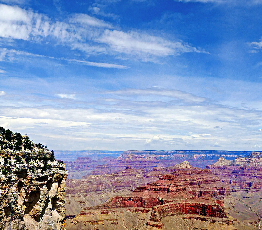
Photo: pom'. via Flickr (CC BY-SA 2.0)
Visiting Grand Canyon National Park with limited mobility can begin at sunrise at Mather Point, where cold air moves across the South Rim and the first light reaches Vishnu Temple nearly 10 miles away. The paved overlook places you beside the canyon edge, with railings at the principal viewing area and open sightlines across layered cliffs. As sunlight descends from the Kaibab Limestone toward the darker inner gorge, the canyon changes from flat silhouette to a landscape more than a mile deep.
The South Rim provides the park’s strongest combination of accessible overlooks, paved paths, shuttle connections, scenic driving, and nearby visitor services. Our team recommends concentrating on three corridors: Mather Point and Yavapai Point, Grand Canyon Village and the western rim, and Desert View Drive. This guide explains how those areas connect, which surfaces and gradients to expect, and how to reduce unnecessary walking.
Visiting Grand Canyon National Park with Limited Mobility: Essential Orientation
Grand Canyon National Park is enormous, but most accessible sightseeing occurs along a relatively narrow section of the South Rim at approximately 7,000 feet above sea level. The Colorado River lies roughly 4,600 vertical feet below the developed rim. Elevation affects breathing, stamina, temperature, and wheelchair propulsion, even on paved routes that appear nearly level.
Why the South Rim is the practical base
The South Rim is reached from Williams by driving approximately 60 miles north, or from Flagstaff by traveling about 80 miles northwest. Grand Canyon Village, the main visitor center area, and the eastern entrance at Desert View are connected by a 23 mile scenic road. Tusayan, just south of the park boundary, has lodging, restaurants, and services for visitors who prefer not to stay inside the park.
The North Rim stands about 1,000 feet higher and is reached by a separate road system. Driving between the rims takes roughly five hours because the nearest road crossing of the Colorado River is far upstream. Seasonal road closures also affect the North Rim. For a first trip with limited mobility, the South Rim offers a more efficient layout and a larger concentration of paved viewpoints.
Distances are deceptive at the canyon
Buildings, parking areas, and overlooks can look close together on a map, yet indirect paths and elevation changes add effort. A companion who can scout parking, operate a wheelchair on grades, or retrieve a vehicle may substantially reduce fatigue. Visitors using portable oxygen should also plan around the rim’s elevation and discuss high altitude travel with their clinician before departure.
Planning for Visiting Grand Canyon National Park with Limited Mobility and Less Walking
A successful day depends on matching transportation to the correct corridor. Private vehicles work best along Desert View Drive. Shuttle buses connect major South Rim locations, while some village roads and the Hermit Road corridor have seasonal vehicle restrictions. Wheelchairs are generally accommodated on park transit within equipment size and capacity limits, but boarding can still take extra time during busy periods.
Use accessibility permits and parking strategically
A Scenic Drive Accessibility Permit can allow qualifying visitors to use certain roads that are otherwise closed to general traffic, including Hermit Road during periods when shuttle transportation is operating. The permit improves access but does not reserve parking at individual overlooks. Ask about the permit when entering the park, then keep a disability placard or accessible license plate displayed as required.
Fees, shuttle operations, road access, and permit procedures can change. Confirm current details on the official park site before traveling, particularly if your plan depends on Hermit Road access or wheelchair boarding. Water availability also deserves attention because pipeline disruptions and conservation measures periodically affect South Rim services. Our coverage of South Rim services and water conservation provides additional planning context.
A low exertion arrival sequence
- Enter through the South Entrance and begin near the main visitor center rather than navigating the denser historic village first.
- Use designated accessible parking close to Mather Point if a placard or plate permits it.
- Visit Mather Point early, when parking pressure and afternoon heat are lower.
- Continue to Yavapai Point for an indoor geological perspective and another paved rim view.
- Save driving overlooks along Desert View Drive for the warmer or busier portion of the day.
Accessible Views When Visiting Grand Canyon National Park with Limited Mobility
No single overlook reveals the whole canyon. Mather Point emphasizes depth and branching side canyons, Yavapai Point clarifies geology, and overlooks farther east provide better views of the Colorado River. Combining two or three viewpoints gives a clearer understanding of the landscape without requiring a long hike.
Visiting Grand Canyon National Park from Mather and Yavapai Points
Mather Point
Mather Point is the most practical first overlook because paved routes connect it with the visitor center area. The principal viewing platforms have protective railings, though crowding can make wheelchair positioning difficult around sunrise and sunset. From here, look east toward Vishnu Temple and west toward the formations surrounding Bright Angel Canyon. The inner gorge is partly concealed, illustrating how deeply the river has cut beneath the broad upper canyon.
Yavapai Point and the geology museum
Yavapai Point sits about one mile west of Mather Point along the rim. Its enclosed observation area looks toward the Colorado River and the mouth of Bright Angel Canyon. Geological displays explain why the canyon’s youngest rim rock, Kaibab Limestone, is about 270 million years old, while exposed Vishnu Basement Rocks near the river approach 1.8 billion years in age.
Choosing viewpoints by access and scenery
| Location | Primary experience | Access character |
|---|---|---|
| Mather Point | Broad first view into central Grand Canyon | Paved approach and developed viewing platforms |
| Yavapai Point | Geology, inner gorge, and river glimpses | Paved rim access with nearby exhibits |
| Hopi Point | Wide western panorama and sunset | Reached through the Hermit Road corridor |
| Lipan Point | Long view of the Colorado River and eastern canyon | Short approach from Desert View Drive parking |
| Desert View | River bend, Painted Desert, and historic watchtower | Developed area, with stairs limiting tower access |
Accessible Trails for Visiting Grand Canyon National Park by Wheelchair or at a Slower Pace
The Rim Trail extends for roughly 13 miles across the South Rim, but surface, width, and gradient vary considerably. Some sections are paved and suitable for many wheelchair users, while others contain steep grades, narrow passages, or unpaved tread. Treat the trail as a collection of short segments rather than committing to an end to end outing.
The Trail of Time between Yavapai and Grand Canyon Village
The Trail of Time follows approximately 2.8 miles of the Rim Trail between Yavapai Geology Museum and the historic village area. Its timeline represents Earth’s 4.56 billion year history, with distance markers corresponding to geological time. Samples of canyon rocks help visitors connect the visible cliffs with their ages and origins. The route is paved, although grades and total distance can challenge manual wheelchair users at this elevation.
How to select a manageable segment
Begin with the paved area between Mather Point and Yavapai Point if your group can manage about a mile in one direction. This stretch stays close to the rim, provides frequent views, and avoids committing to the full Trail of Time. If stamina decreases, one person can return for the vehicle or the group can use nearby transit connections rather than retracing the entire route.
- Choose firm, paved sections and turn around before fatigue affects braking or balance.
- Carry water because high elevation and dry air increase fluid loss even in cool weather.
- Use sun protection year round. Snow on the ground does not prevent strong ultraviolet exposure.
- Keep several feet back from unprotected edges, especially where paved routes transition to informal footpaths.
- Expect winter ice in shaded areas and abrupt temperature changes during spring and autumn.
Grand Canyon Village and Hermit Road Without Long Walks
Grand Canyon Village combines historic architecture with western rim views, but its roads, rail tracks, parking areas, and changes in grade make spontaneous exploration tiring. A practical approach is to choose one historic stop and one Hermit Road overlook. This preserves energy for the canyon itself while avoiding repeated transfers between a vehicle, wheelchair, and shuttle.
Historic buildings near the rim
Hopi House, designed by Mary Colter and completed in 1905, draws on Pueblo building traditions, while the nearby El Tovar opened the same year as a railway hotel. Lookout Studio, another Colter building, appears to grow from the rim’s Kaibab Limestone. Interior access varies among these historic structures because of narrow passages, stairs, and original floor plans. Their exteriors and surrounding canyon views can still be appreciated from developed village paths.
Selecting a western overlook
Hopi Point projects farther into the canyon than many South Rim overlooks, producing an unusually broad view in both directions. Powell Point has a memorial honoring the Colorado River expeditions led by John Wesley Powell in 1869 and 1871. Farther west, Pima Point provides one of the corridor’s clearest river views. Choose a single overlook based on available energy, since repeated boarding and unloading can become the most demanding part of the excursion.
Driving East Through the Canyon’s Geological Story
Desert View Drive rewards visitors who need scenery close to the vehicle. The road follows the South Rim east through pinyon pine and Utah juniper woodland, passing overlooks that reveal progressively longer sections of the Colorado River. Pullouts vary in pavement, slope, and distance from the view, so a companion should scout the approach before unloading mobility equipment.
Lipan Point and the river below
At Lipan Point, the canyon opens toward the broad Unkar Delta, where Ancestral Puebloan farmers lived between roughly 800 and 1200 CE. From the overlook, several river bends can be followed through the inner gorge. The exposed basement rocks show the canyon’s deepest geological layer, while tilted formations in the eastern canyon preserve evidence of ancient faulting.
Near the railing, wind moves over the rim with little warning, cooling your hands even when the parking area feels warm. The ground drops through pale cliffs and red slopes before reaching the dark inner gorge. Far below, the Colorado appears narrow and quiet, although its rapids can carry across the canyon as a faint, low sound. That combination of visible depth and delayed sound conveys the scale more clearly than a photograph.
Desert View and the Watchtower
Mary Colter’s 70 foot Desert View Watchtower was completed in 1932, with stonework inspired by ancestral structures of the Colorado Plateau. The ground level can be experienced without climbing the tower, but upper levels require stairs. Outside, developed paths provide views toward the Painted Desert, the Little Colorado River gorge, and the Colorado turning west into the main canyon.
Matching Conditions to Mobility Needs
Rim weather follows elevation rather than conditions in Phoenix or the canyon bottom. Winter snow can remain on shaded pavement after exposed areas have dried. Summer afternoons bring intense sunlight, low humidity, and occasional thunderstorms. Lightning is especially dangerous at projecting overlooks, where railings and isolated trees do not provide safe shelter.
Seasonal tradeoffs at the South Rim
| Period | Typical mobility concern | Useful strategy |
|---|---|---|
| Winter | Snow, refrozen runoff, and cold wheelchair components | Favor midday outings and cleared developed overlooks |
| Spring | Strong wind and rapid temperature changes | Carry insulating layers and secure loose equipment |
| Summer | Heat, ultraviolet exposure, and afternoon storms | Use early hours and return to a vehicle when thunder begins |
| Autumn | Cold mornings and shorter daylight | Schedule longer paved segments after the rim warms |
Equipment that solves common problems
Visiting Grand Canyon National requires planning for dry air, rough pavement transitions, and limited shade rather than technical trail equipment. Manual wheelchair users may benefit from assistance on grades that feel modest at sea level but become taxing near 7,000 feet. Keep essential medication and water with the traveler instead of leaving them in a parked vehicle.
- Bring a compact tire pump, patch kit, and the correct tools for adjustable footrests.
- Carry a lap blanket because seated visitors cool faster in rim wind.
- Use gloves with secure grip surfaces for braking on sloped pavement.
- Pack water in containers that can be opened without fine finger movement.
- Photograph mobility equipment settings before folding or disassembly.
Building a Comfortable Grand Canyon Visit
A manageable South Rim plan uses short, distinct experiences: a sunrise or morning view near Mather Point, geological interpretation at Yavapai, one historic village stop, and a drive east to Lipan Point or Desert View. Rest between zones instead of filling every interval with another overlook. The canyon changes with angle and light, so carefully chosen stops reveal more than a rushed sequence of similar views.
Our team recommends identifying one essential viewpoint and treating everything else as optional. Account for altitude, wind, transfers, and the distance between parking and the rim before judging what fits into a day. With that structure, visitors with limited mobility can experience the canyon’s immense depth, exposed geological record, human history, and Colorado River corridor while keeping effort predictable and safety at the center of the plan.
Want to keep exploring? Browse all our Grand Canyon guides and articles for more trip-planning tips and ideas.
Gear & Essentials
Tell us about your trip and we will add what else you will want:
The basics
Worth having in the car whatever the park.
For this trip
Traveling with kids
Bringing a pet
RVing
Backcountry
Winter conditions
On the water
Photography
Accessibility
As an Amazon Associate we earn from qualifying purchases, at no extra cost to you.