10 Best Summer Hikes in Glacier National Park
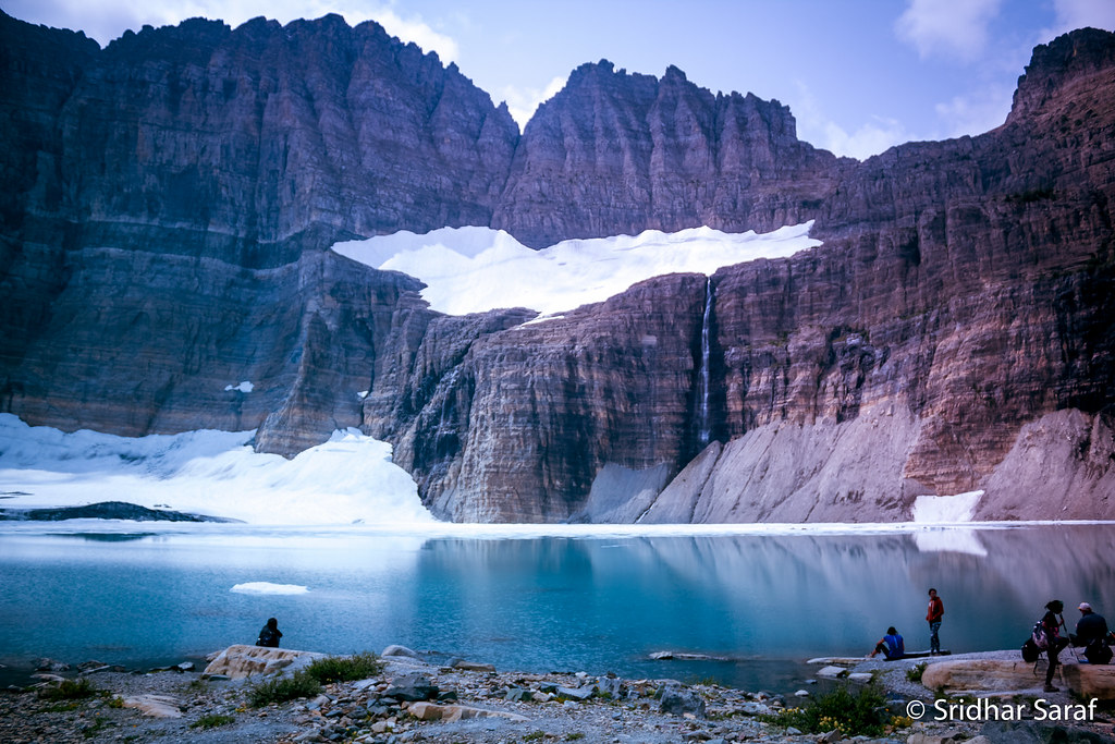
Photo: SridharSaraf via Flickr (CC BY-SA 2.0)
Our 10 Best Summer Hikes in Glacier National Park cover the park’s major landscapes, from cedar forest around Avalanche Lake to alpine tundra along the Continental Divide. Most visitors should target mid July through September, when Going-to-the-Sun Road and high passes are most likely to be open. Early summer brings waterfalls and lingering snow, while September offers cooler walking temperatures, fewer insects, and gradually shorter days.
Trail access varies sharply across Glacier’s million acres. Logan Pass sits at 6,646 feet, Many Glacier occupies the park’s wildlife-rich northeast corner, and Two Medicine requires a separate approach from the southeast. A route that looks close on a map can involve hours of driving around the Continental Divide, so our team recommends choosing one park region per day.
When the 10 Best Summer Hikes in Glacier National Park Become Accessible
Glacier’s hiking summer develops from the valleys upward. Forest routes such as Avalanche Lake and Virginia Falls usually become practical before alpine trails including Highline, Siyeh Pass, and Ptarmigan Tunnel. Snowfields, stream crossings, and avalanche debris can remain after a trailhead becomes reachable, particularly on shaded north-facing slopes.
Glacier’s Hiking Season at a Glance
The table below compares the main hiking windows rather than fixed calendar seasons. Snowpack controls the opening of Going-to-the-Sun Road, and individual years can differ by several weeks. Afternoon thunderstorms are possible throughout summer, especially near exposed passes where retreat options are limited.
| Period | Crowds | Typical Conditions | Likely Access | Best Uses |
|---|---|---|---|---|
| Late May to mid June | Low to moderate | Wet valleys, strong waterfalls, deep alpine snow | Lower trails and partial road access | Forest walks, wildlife watching, waterfall hikes |
| Late June to early July | Increasing quickly | Long daylight, muddy sections, hazardous snow on passes | Road access expanding, high trails uncertain | Valley lakes and lower elevation routes |
| Mid July through August | Highest | Warm valleys, open passes, thunderstorms, wildfire smoke possible | Broadest trail and road access | Highline, Siyeh Pass, Ptarmigan Tunnel |
| September to early October | Moderate to low | Cool mornings, early snow possible, shorter daylight | Excellent until storms or seasonal closures intervene | Long hikes, fall color, quieter wildlife viewing |
Road Openings Control the High Country
Going-to-the-Sun Road provides access to Logan Pass, Siyeh Bend, Jackson Glacier Overlook, and several point-to-point hikes. Plowing the road involves clearing drifts that can rise many feet above the pavement near the Continental Divide. Until the alpine section opens, Highline and Hidden Lake Overlook cannot be approached from their normal summer trailheads.
Parking congestion changes the practical difficulty of popular hikes. A moderate route can require a predawn departure, a shuttle connection, or extra walking from an overflow area. Vehicle-entry systems, shuttle operations, fees, road status, and temporary trail closures can change annually, so confirm current details on the official park site before fixing an itinerary.
How We Chose the 10 Best Summer Hikes in Glacier National Park
Our selection balances scenery, ecological variety, route quality, and the ability to build a realistic trip. Several hikes reach the Continental Divide, while others remain low enough to work during unsettled weather. Together they cover Lake McDonald, Logan Pass, St. Mary, Many Glacier, and the park’s eastern alpine country.
The 10 Best Summer Hikes Compared
Distances and elevation gains are approximate because boat use, turnaround points, and trailhead connections can alter a route. Point-to-point hikes also require transportation planning. The difficulty ratings assume dry summer tread rather than snow, ice, heavy smoke, or extreme heat.
| Hike | Distance | Approximate Gain | Difficulty | Area |
|---|---|---|---|---|
| Highline Trail to The Loop | 11.8 miles one way | 830 feet | Strenuous | Logan Pass |
| Grinnell Glacier | 10.6 miles round trip | 1,600 feet | Strenuous | Many Glacier |
| Iceberg Lake | 9.7 miles round trip | 1,275 feet | Moderate to strenuous | Many Glacier |
| Ptarmigan Tunnel | 10.7 miles round trip | 2,300 feet | Strenuous | Many Glacier |
| Siyeh Pass | About 10 miles one way | About 2,240 feet | Strenuous | St. Mary corridor |
| Swiftcurrent Pass | About 14 miles round trip | About 2,400 feet | Very strenuous | Many Glacier |
| Avalanche Lake | 5.9 miles round trip | About 750 feet | Moderate | Lake McDonald |
| Hidden Lake Overlook | 2.7 miles round trip | About 460 feet | Easy to moderate | Logan Pass |
| St. Mary and Virginia Falls | About 3.6 miles round trip | About 525 feet | Moderate | St. Mary |
| Cracker Lake | 12.6 miles round trip | About 1,400 feet | Strenuous | Many Glacier |
Choose According to Your Priorities
Strong hikers with only one clear day should prioritize Highline, Siyeh Pass, or Grinnell Glacier. Families and visitors adjusting to elevation generally have better experiences at Avalanche Lake, Virginia Falls, or Hidden Lake Overlook. Many Glacier delivers the strongest concentration of long routes, but its trailheads are far from West Glacier and should be grouped into a separate day or overnight stay.
- Best first alpine hike: Hidden Lake Overlook, provided the trail is open and snow-free.
- Best waterfall route: St. Mary and Virginia Falls during early summer runoff.
- Best glacier view: Grinnell Glacier, with close views of ice, moraines, and glacially carved rock.
- Best long traverse: Siyeh Pass, which crosses open tundra below 10,014-foot Mount Siyeh.
- Best wildlife corridor: Swiftcurrent Pass, where moose, bears, bighorn sheep, and deer may use nearby habitat.
Signature Trails Along the Continental Divide
The park’s alpine routes cross rocks of the Belt Supergroup, layers of argillite, limestone, and quartzite deposited in ancient shallow seas more than a billion years ago. Glaciers later carved these tilted beds into arêtes, cirques, and steep U-shaped valleys. That geology explains both the scale of the views and the exposure found on several high routes.
Two of the 10 Best Summer Hikes from Logan Pass
Highline Trail to Granite Park and The Loop
Highline begins across Going-to-the-Sun Road from the Logan Pass visitor area and follows the Garden Wall toward Granite Park Chalet. The opening section includes a narrow ledge with a hand cable, followed by rolling traverses through beargrass, glacier lilies, and open slopes used by bighorn sheep. Continuing past the chalet to The Loop creates an 11.8-mile point-to-point hike with a long, steep descent.
On the Garden Wall, the trail feels cut into the mountainside. Angular stone sits underfoot, the cliff rises close on one side, and the McDonald Creek valley drops thousands of feet on the other. Wind crosses the slope without obstruction, carrying marmot whistles and the faint sound of traffic far below. The exposure is visually dramatic even where the tread remains level.
Hidden Lake Overlook
This shorter route climbs from Logan Pass on boardwalks and gravel trail through Hanging Gardens. Snow often lingers beside the path after the road opens, and mountain goats commonly use the surrounding cliffs and meadows. The overlook faces Bearhat Mountain above Hidden Lake, but wildlife activity can cause temporary closures beyond the overlook. Visitors should never approach goats or allow them access to sweat-soaked gear.
A High Pass Above the St. Mary Valley
Siyeh Pass
Siyeh Pass is commonly walked from Siyeh Bend to Sunrift Gorge, producing a demanding point-to-point route through Preston Park and over a pass near 8,100 feet. The climb moves from subalpine forest into flower meadows beneath Mount Siyeh, then crosses pale scree before descending toward the Baring Creek drainage. Little shade exists above Preston Park, and the descent is lengthy enough to punish knees even though most climbing occurs early.
Many Glacier Routes for Long Summer Days
Many Glacier holds four of the longest routes in this list: Grinnell Glacier, Iceberg Lake, Ptarmigan Tunnel, and Swiftcurrent Pass. Starting early matters because the approach road consumes substantial time from either side of the park, while afternoon weather can make exposed terrain uncomfortable. Bear activity also causes occasional trail closures, so hikers should arrive with an alternate route in the same area.
Glacial Lakes and Open Slopes
Grinnell Glacier and Iceberg Lake
Grinnell Glacier climbs past Swiftcurrent and Josephine lakes before traversing open slopes above turquoise Lower Grinnell Lake. The final ascent crosses sun exposed rock and passes seasonal waterfalls. Iceberg Lake follows Ptarmigan Creek into a cirque enclosed by the roughly 3,000 foot walls beneath Iceberg Peak. Snow and floating ice can persist at the lake through summer, making warm layers useful even when the trailhead feels hot.
Tunnels and Continental Divide Passes
Ptarmigan Tunnel and Swiftcurrent Pass
Ptarmigan Tunnel shares its first miles with Iceberg Lake before climbing through forest and switchbacks to Ptarmigan Lake. The 240 foot tunnel, completed in 1930, pierces the Ptarmigan Wall and opens onto views of the Belly River country. Swiftcurrent Pass follows a chain of lakes, climbs steep switchbacks above the valley, and reaches the Continental Divide near 7,185 feet. It demands more endurance and dependable weather than the lake routes.
Cracker Lake
Cracker Lake leads into a broad cirque below 10,057 foot Mount Siyeh. Fine glacial sediment gives the lake its opaque turquoise color, while abandoned mining equipment recalls the short lived copper boom of the late 1890s. The route includes horse traffic, muddy forest, and open avalanche paths. Carry bear spray where it is immediately reachable because dense vegetation limits sight lines along parts of the approach.
How Crowds Change the Hiking Experience
July and August bring the broadest trail access, but they also concentrate vehicles at Logan Pass, Avalanche, and Many Glacier. Full parking areas can delay a start until temperatures and thunderstorm risk have increased. Busy trails also require more frequent passing stops. Those interruptions matter on Highline’s narrow opening traverse and on steep sections of Grinnell Glacier where hikers should avoid stepping onto fragile vegetation.
Match Your Start Time to the Trail
| Trail Type | Useful Start Strategy | Main Reason |
|---|---|---|
| Logan Pass routes | Use an early shuttle or arrive before peak traffic | Limited alpine parking and exposed afternoon terrain |
| Many Glacier day hikes | Begin near sunrise | Long mileage, wildlife activity, and limited shade |
| Waterfall and forest hikes | Visit early morning or late afternoon | Fewer trail bottlenecks and softer light |
| Point to point traverses | Schedule transportation before hiking | Missing a connection can leave hikers far from their vehicle |
Finding Quieter Conditions
September usually offers the best balance of open high trails and reduced congestion. Night temperatures can fall below freezing at elevation, and the first substantial snowfall may temporarily cover passes. During peak summer, hikers seeking space should favor Cracker Lake over Grinnell Glacier or start St. Mary and Virginia Falls from the eastern side early in the day. Quiet does not reduce bear precautions, especially where berry producing shrubs border the trail.
Reservations, Gear, and a Practical Decision Plan
Day hiking these routes generally does not require a wilderness camping permit. Vehicle access programs, commercial boat schedules, lodging reservations, and campground booking windows can still shape an itinerary months before arrival. Boat rides can shorten some approaches near Josephine Lake, but hikers should understand the full walking distance in case space is unavailable. Wilderness permits become relevant when converting routes into overnight trips.
Choose the Right Seasonal Window
- Choose late June or early July for waterfalls and long daylight, then focus on Avalanche Lake, Virginia Falls, and other lower routes if snow remains on passes.
- Choose mid July through August for the greatest probability of reaching every trail on the list, accepting heavier traffic and warmer afternoons.
- Choose September for cooler long distance hiking, fewer insects, and lighter crowds, while carrying insulation for rapid weather changes.
Carry for Glacier’s Actual Conditions
Each hiker should carry bear spray, at least two liters of water, food beyond the planned duration, rain protection, insulation, navigation, and a headlamp. Trekking poles help on Siyeh Pass scree and the descent from Granite Park. Snow traction may be appropriate early in the season, but traction devices do not make a steep snow crossing safe without the skills to arrest a fall. Turn around when footing exceeds the group’s ability.
Planning Your Glacier Summer Hikes
The 10 Best Summer Hikes provide a useful framework because they include short overlooks, waterfall walks, glacial lakes, and full day crossings of the Continental Divide. Build the trip geographically: combine Avalanche Lake with the Lake McDonald corridor, reserve a clear day for Logan Pass, and devote separate days to Many Glacier. This approach reduces driving and creates room for weather related substitutions.
For the widest choice, visit after the alpine roads and passes have opened. For waterfalls and lower crowds, accept a smaller trail menu earlier in summer. September suits experienced hikers who can manage cold mornings and shorter daylight. Whichever period you choose, start early, carry bear spray, and keep one lower elevation route available when snow, smoke, thunderstorms, or wildlife closures change the day’s plan.
Want to keep exploring? Browse all our Glacier guides and articles for more trip-planning tips and ideas.
Gear & Essentials
Tell us about your trip and we will add what else you will want:
The basics
Worth having in the car whatever the park.
For this trip
Traveling with kids
Bringing a pet
RVing
Backcountry
On the water
Photography
Accessibility
As an Amazon Associate we earn from qualifying purchases, at no extra cost to you.