Glacier National Park Camping Guide: Campgrounds, Reservations and Tips
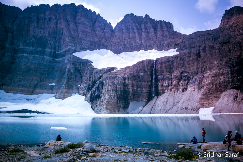
Photo: SridharSaraf via Flickr (CC BY-SA 2.0)
Glacier National Park camping comes with a constraint that surprises many first time visitors: the park’s developed campgrounds generally do not provide water, sewer, or electrical hookups. Campers trade resort style infrastructure for sites beside glacial lakes, cedar forest, and trailheads leading directly into the Northern Rockies. RV travelers must plan around battery capacity, holding tanks, generator rules, and vehicle length before choosing a site.
Location matters as much as the campsite itself. The Continental Divide separates Glacier’s west side rain forest from the drier, higher east side, while the Going to the Sun Road crosses roughly 50 mountain miles between the West Glacier and St. Mary entrances. Driving across the park can consume several hours once wildlife, road congestion, construction, and scenic stops are included. Our team recommends choosing a campground according to the trails and valleys you want to explore, rather than treating every campground as an interchangeable base.
How Glacier National Park Camping Is Organized by Area
Glacier has several distinct camping regions. Apgar, Fish Creek, Avalanche, and Sprague Creek serve the Lake McDonald corridor on the west side. St. Mary and Rising Sun provide access to the eastern half of the Going to the Sun Road. Many Glacier and Two Medicine occupy separate mountain valleys, each reached from the east side rather than directly from the central road corridor.
The North Fork campgrounds, including Bowman Lake, Kintla Lake, Quartz Creek, and Logging Creek, are smaller and more primitive. Their narrow, rough approach roads exclude or discourage many larger vehicles. These campgrounds reward well prepared tent campers with quieter forests and immediate access to remote lakes, but they are poor choices for travelers who need reliable cellular service, frequent resupply, or easy pavement.
West side campgrounds and Lake McDonald
Apgar is the park’s largest and most convenient west side base, close to the foot of Lake McDonald and the services around West Glacier. Its forested loops accommodate a broader range of camping equipment than the smaller lakeshore campgrounds. Mature conifers provide shade, although vegetation and privacy vary considerably by loop and site.
Fish Creek, Avalanche, and Sprague Creek
Fish Creek occupies wooded terraces near the northwest shore of Lake McDonald and feels more removed from entrance traffic than Apgar. Avalanche sits farther up the Going to the Sun Road among western red cedar and western hemlock, with the 4.5 mile round trip Trail of the Cedars and Avalanche Lake route nearby. Sprague Creek is compact and scenic, but its tight roads and smaller sites favor tents, vans, and short camping units.
East side valleys and higher elevations
East side camping places visitors closer to open grasslands, alpine trail systems, and some of Glacier’s most productive wildlife habitat. St. Mary offers the most practical base near the park’s eastern entrance, while Rising Sun sits farther inside the park near St. Mary Lake. The relative lack of dense coastal forest means stronger wind, colder nights, and less consistent shade than campers often encounter around Lake McDonald.
Many Glacier lies around 4,500 feet in a basin framed by Mount Grinnell, Swiftcurrent Mountain, and the Garden Wall. Two Medicine sits above 5,000 feet beside Two Medicine Lake. Both valleys offer direct access to major trails, but they are separate destinations with their own entrance roads. They should not be treated as quick detours from a campsite on the opposite side of the park.
Glacier National Park Camping: Campgrounds Compared
The table below compares the campground regions by setting and practical fit. Individual loops, site dimensions, opening periods, and reservation methods can change, so use these categories to narrow the search before inspecting a specific site listing.
| Camping area | Setting and access | Best suited to | Important limitation |
|---|---|---|---|
| Apgar and Fish Creek | Forested west side near Lake McDonald | First visits, families, larger camping units | Long drive to Many Glacier and Two Medicine |
| Avalanche and Sprague Creek | Central Lake McDonald corridor | Tent campers, vans, early trail access | Smaller sites and tighter vehicle constraints |
| St. Mary and Rising Sun | Open east side near St. Mary Lake | Going to the Sun Road exploration | Wind and limited natural shade |
| Many Glacier | Glacial basin with extensive trail network | Hikers and wildlife watchers | Isolated from the main road corridor |
| Two Medicine | High valley beside Two Medicine Lake | Day hiking and quieter east side stays | Fewer nearby resupply options |
| North Fork lakes | Remote forest reached by rough roads | Self sufficient tent campers | Unsuitable for many trailers and motorhomes |
Many Glacier for trail access
Many Glacier is the strongest choice for hikers targeting Grinnell Glacier, Iceberg Lake, Ptarmigan Tunnel, or Swiftcurrent Pass. The Grinnell Glacier route is roughly 10 to 12 miles round trip depending on the starting point and any seasonal boat use, while Iceberg Lake is about 9.6 miles round trip. Starting from this valley avoids a long early morning drive and improves the chances of finding trailhead parking.
At the upper end of the valley, gravel crunches underfoot while cool air drains from the surrounding cirques. The peaks rise abruptly rather than appearing on a distant horizon, and beargrass, willow, and open avalanche slopes break up the dark conifer forest. In the evening, voices carry across the campground until wind in the trees and flowing water become the dominant sounds. Temperatures can fall quickly after sunlight leaves the basin.
Two Medicine for a contained mountain itinerary
Two Medicine works particularly well for campers who want several days of hiking without moving their vehicle. Trails reach Aster Park, Upper Two Medicine Lake, Cobalt Lake, Dawson Pass, and Pitamakan Pass. The combined Dawson and Pitamakan loop is approximately 18 miles and involves substantial elevation gain, making it a demanding full day rather than a casual campground walk.
The valley also reveals Glacier’s bedrock unusually well. Layered argillite and limestone belonging to the Belt Supergroup form the surrounding ridges. These rocks began as sediment deposited more than a billion years ago, then were uplifted and later carved by glaciers into steep arêtes, cirques, and U shaped valleys.
Choosing a Tent, Van, Trailer, or Motorhome Site
A campground accepting RVs does not mean every site fits every RV. Glacier’s older loops were laid out around mature trees and natural terrain, producing curved parking pads, low branches, and limited maneuvering room. Reservation listings commonly distinguish between driveway length and the maximum length of individual equipment. A tow vehicle and trailer must fit according to the rules attached to that particular site.
Leveling can also be difficult. Some paved and gravel pads slope enough to require blocks, while tent areas may contain exposed roots or compacted ground. Site photographs help, but campers should also read the listed driveway shape, width, and grade. Slide outs and awnings can conflict with trees even when the vehicle technically fits the parking pad.
What developed sites generally provide
- Defined parking and tent space: The amount of usable ground varies significantly among individual sites.
- Food storage infrastructure: Bear resistant lockers may be shared or assigned, depending on the campground and loop.
- Basic campground facilities: Developed areas generally have toilets and access to water during their operating season.
- Fire containment: Where fires are permitted, campers must use designated structures and obey current restrictions.
- No standard utility hookups: Plan to camp without site based electricity, water, or sewer connections.
Privacy, shade, and exposure
Fish Creek and Avalanche generally provide the strongest forest enclosure, with understory vegetation separating some sites. Apgar combines wooded loops with more open, heavily used areas. St. Mary has expansive views but less protection from sun and wind. Many Glacier and Two Medicine fall between these extremes, with trees in portions of the campgrounds and exposed sites elsewhere.
Campers sensitive to road noise should examine the map for entrance lanes, restroom paths, generator permitted loops, and sites beside major campground roads. Lakeshore proximity does not guarantee a water view because vegetation and neighboring sites often intervene. It can also mean colder air, more insects, and stronger evening breezes.
Glacier National Park Camping Reservations and Tips
Glacier uses a mixture of reservable inventory and sites released closer to arrival. Booking practices vary among campgrounds and can change between operating seasons. Recreation.gov listings may open inventory on a rolling window months ahead, while some sites can be released only a few days before arrival. First come camping, when offered, requires flexibility because summer demand frequently exceeds the available supply.
Create a Recreation.gov account before the booking date, save traveler details, and search by the exact campground rather than by the park alone. Confirm current booking windows, fees, campground opening dates, vehicle restrictions, and road access on the official park site before purchasing transportation or nonrefundable lodging.
A practical reservation sequence
- Choose the valley according to your highest priority hikes and drives.
- Enter the total length and type of every vehicle or camping unit accurately.
- Check several acceptable arrival dates rather than relying on one weekend.
- Open the campground map and identify multiple suitable loops and sites.
- Review generator rules, food storage requirements, and occupancy limits before payment.
- Keep a backup outside the park until the campground reservation is confirmed.
Splitting a stay across the park
A split stay can save hours of backtracking. Campers might pair several nights around Lake McDonald with a second reservation in Many Glacier, St. Mary, or Two Medicine. This arrangement also exposes travelers to Glacier’s pronounced ecological transition, from the moist cedar and hemlock forest west of the Continental Divide to aspen parkland, grassland, and wind exposed slopes on the east side.
Moving camp has costs. Breaking down wet tents, navigating midday traffic, and waiting for a new site can consume much of a day. A split itinerary works best with at least three nights in each region. For shorter trips, one strategically chosen campground and an early start usually produces more usable trail time.
Gear for Glacier’s Weather and Wildlife
Glacier’s camping conditions can shift from hot afternoon sun to cold rain within hours. Even in July and August, valleys above 4,500 feet can experience nights near freezing. A sleeping bag rated around 20 to 30 degrees Fahrenheit, an insulated pad, waterproof outerwear, and dry sleeping clothes provide a practical margin. Tent campers should use a full rainfly, bring extra stakes for east side wind, and avoid placing tents in depressions where stormwater collects.
Build a weatherproof camp
Strong gusts are common around St. Mary, Two Medicine, and exposed portions of Many Glacier. Stake every tent corner and guylight, then secure loose chairs, tablecloths, and cooking equipment before leaving for the day. West side campers face a different challenge: prolonged rain beneath dense forest. A freestanding tarp can protect the cooking area, but it must never be attached to vegetation in a way that damages bark or blocks a neighboring site.
Store every scented item correctly
Black bears and grizzly bears use every major Glacier valley. Food, garbage, cookware, toiletries, coolers, pet food, and empty beverage containers belong in an approved storage locker or hard-sided vehicle whenever they are unattended. Keep bear spray accessible on trails and around camp, rather than buried inside a pack. Cooking clothes can retain grease and food odors, so store heavily soiled garments with other scented items instead of taking them into the tent.
- Sleep system: Insulated pad, warm bag, knit hat, and dry base layers.
- Storm protection: Full rainfly, sturdy stakes, guylines, and waterproof pack cover.
- Utility equipment: Headlamp, leveling blocks, battery bank, and water containers.
- Wildlife equipment: Bear spray carried where it can be reached immediately.
What to Do Without a Long Drive
A well-selected campsite reduces dependence on crowded parking areas. Before leaving camp, download maps because mobile coverage is unreliable in mountain valleys and nearly absent in much of the North Fork. Start longer hikes around sunrise, carry water and food for delays, and leave an itinerary with someone who knows your route. Afternoon thunderstorms can produce lightning, hail, falling branches, and rapid temperature changes on exposed passes.
Short outings near the west side
From Apgar, campers can walk or cycle toward Lake McDonald’s southern shore and watch evening light move across Stanton Mountain. Johns Lake Loop, farther up the corridor, covers roughly 2 miles through cedar forest and connects with viewpoints near McDonald Creek. Campers based near the North Fork lakes can explore the shorelines at Bowman or Kintla, although cold water, sudden wind, and limited rescue access make conservative paddling decisions essential.
East side walks for arrival and departure days
Running Eagle Falls near Two Medicine requires only a short walk and reveals an unusual waterfall that can emerge through an opening in the rock during higher flows. Near St. Mary, the Beaver Pond Loop covers approximately 3.6 miles through grassland, aspen, and forest affected by historic fire. These lower commitment walks fit campsite transition days when packing, travel, or changing weather leaves insufficient time for a high pass.
How the Camping Season Changes
Most Glacier National Park camping demand concentrates between late June and early September, but elevation and slope exposure matter more than the calendar alone. High trails can retain snow into July, while lower west side forests may become muddy after sustained rain. Smoke from regional wildfires can affect visibility and breathing conditions later in summer. Campers should carry warm layers and rain protection during every part of the operating season.
| Period | Typical advantages | Likely complications |
|---|---|---|
| Late spring to early summer | Long daylight, strong waterfalls, fewer insects at higher elevations | Snow-covered trails, cold nights, wet campsites, limited high-road access |
| Mid-summer | Broadest trail access and warmest average conditions | Heavy demand, afternoon storms, mosquitoes, crowded parking |
| Late summer | Drier trails, cooler evenings, productive hiking weather | Wildfire smoke, low water levels, early cold snaps |
| Early autumn | Changing aspen and cottonwood color, quieter valleys | Shorter daylight, freezing nights, snow, reduced services |
Early season requires snow planning
Trails such as Grinnell Glacier, Ptarmigan Tunnel, and the Dawson and Pitamakan route can remain hazardous after valley campgrounds become accessible. Snowfields may conceal the tread or create dangerous runouts above rocks and streams. Choose lower routes until current trail reports support an alpine objective. Waterproof boots help in saturated ground, but traction devices and an ice axe only improve safety when the user has the skills to employ them correctly.
Late season rewards warmer sleep systems
September often brings crisp days and reduced insect activity, followed by nights below freezing. Water containers, filters, and exposed RV plumbing can freeze, so keep filters inside the sleeping area and protect vulnerable lines. Daylight decreases quickly at Glacier’s latitude. Begin hikes early, carry a headlamp even on moderate routes, and allow additional time for wildlife encounters because bears spend more time feeding as winter approaches.
Plan Your Glacier National Park Camping Stay
The strongest itinerary begins with geography. Choose Lake McDonald for west side forest and central road access, Many Glacier for concentrated hiking, Two Medicine for a self-contained mountain valley, or the North Fork for primitive lakeside camping. Match the selected site to the complete length of your equipment, then prepare for dry camping, variable weather, limited connectivity, and strict food storage.
Secure the campsite before building the rest of the trip, but retain a realistic backup outside the park. A reservation in the correct valley can remove hours of driving and make early trail starts much easier. With a weatherproof shelter, conservative wildlife practices, and activities matched to seasonal conditions, Glacier National Park camping becomes a practical base for exploring the park rather than a daily logistical obstacle.
Want to keep exploring? Browse all our Glacier guides and articles for more trip-planning tips and ideas.
Gear & Essentials
Tell us about your trip and we will add what else you will want:
The basics
Worth having in the car whatever the park.
For this trip
- Camp lantern Etekcity Camping Lanterns 4-Pack LED
- Camping hammock Wise Owl Outfitters Camping Hammock
- Camping pillow Hikenture Inflatable Camping Pillow
- Lighter & matches BIC Maxi Pocket Lighters 10-Pack
- Shelter tarp Amazon Basics Waterproof Multipurpose Camping Tarp
- Tent Camping Tent 2-4 Person Easy Setup
Traveling with kids
Bringing a pet
RVing
Backcountry
Winter conditions
On the water
Photography
Accessibility
As an Amazon Associate we earn from qualifying purchases, at no extra cost to you.