Zion National Park in Spring: What to Expect and What to Do
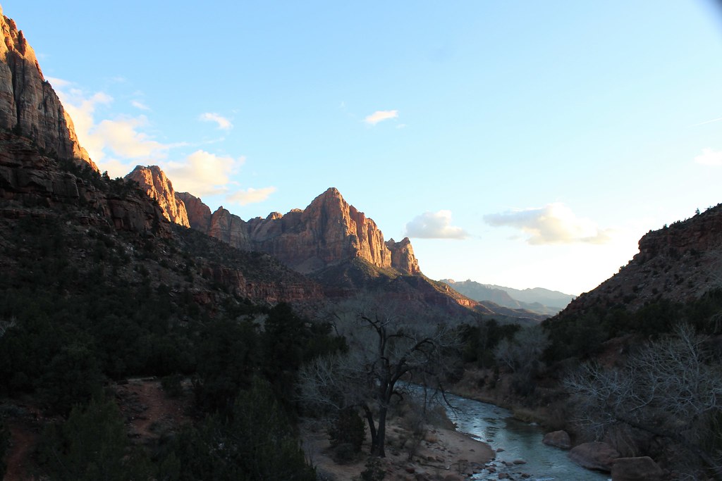
Photo: agcaddesigns.com Architectural Renderings via Flickr (CC BY 2.0)
Zion National Park spring mornings begin cool and shadowed at the Temple of Sinawava, where the Virgin River fills the narrow canyon with the sound of snowmelt. Cottonwood leaves brighten beneath 2,000 foot Navajo Sandstone walls, while sunlight descends slowly from the rim toward the canyon floor. The temperature can rise sharply once that light arrives, so a fleece that feels necessary at 7 a.m. may be packed away before lunch.
Spring brings comfortable hiking temperatures, flowering desert plants, strong waterfalls, and complicated trail conditions. March can feel wintry at higher elevations, while late May often resembles summer in Zion Canyon. Our team treats spring as three distinct periods because weather, river flow, crowds, shuttle operations, and trail access change considerably between them.
Why Visiting Zion National Park in Spring Requires Flexible Planning
Zion spans several ecological zones and more than 5,000 feet of elevation. The lowest terrain near Coalpits Wash sits around 3,700 feet, while Horse Ranch Mountain reaches 8,726 feet in the Kolob Canyons area. A warm afternoon beside the Virgin River can coincide with lingering snow and mud on high trails near Lava Point. Forecasts for Springdale describe Zion Canyon reasonably well, but they do not represent conditions across the entire park.
How Zion National Park Spring Weather Changes Month by Month
March typically brings cool mornings, mild afternoons, and the greatest chance of encountering snow or ice on elevated, shaded paths. April usually provides the most balanced temperatures for strenuous hiking, though rapid weather swings remain common. By May, daytime temperatures on exposed trails can become hot, especially on the sand and slickrock of the East Side. Cold fronts can still lower temperatures abruptly in every spring month.
Snowmelt affects waterfalls and river routes
Runoff feeds seasonal waterfalls at Emerald Pools, Weeping Rock, and along the cliffs after storms. It also raises the Virgin River through The Narrows. The National Park Service generally closes the bottom up Narrows route when river flow exceeds its established safety threshold, and sustained snowmelt can keep the route unavailable for days or weeks. Water temperatures remain dangerously cold even when the canyon air feels warm.
Rain creates a separate hazard
Flash floods can occur when rainfall reaches the watershed upstream, including areas beneath blue sky from the hiker’s perspective. The Narrows, Orderville Canyon, and other confined drainages offer few escape points. Check the park’s flood potential rating and current river data before entering any slot canyon.
Zion National Park in Spring: Conditions by Month
Spring does not progress evenly. Elevation, shade, wind direction, and recent storms determine whether a trail is dusty, muddy, icy, or flooded. The table below compares the practical differences among early, middle, and late spring, with the other seasons included to help travelers decide whether spring matches their priorities.
| Period | Typical conditions | Crowd pattern | Access and best activities |
|---|---|---|---|
| March | Cold mornings, mild afternoons, possible snow and ice | Moderate overall, busy during school breaks | Lower canyon hikes, scenic drives, waterfalls, Watchman Trail |
| April | Comfortable hiking temperatures, variable storms, strong runoff | Busy, especially weekends and holiday periods | Long day hikes, Emerald Pools, East Side exploration |
| May | Warm to hot afternoons, cool river water, occasional storms | Very busy by late month | Early morning hiking, canyon overlooks, higher terrain as snow clears |
| Summer | Very hot, with monsoon storms later in the season | Heavy | River activities when conditions permit, dawn and evening walks |
| Autumn | Cooling temperatures and generally lower runoff | Heavy in early autumn, easing later | Long hikes, The Narrows when flow and weather cooperate |
| Winter | Cold, quieter, with ice and occasional snow | Lowest | Scenic drives, short canyon walks, photography |
March favors lower elevation hiking
In March, choose trails that receive direct sun and remain relatively low. The Watchman Trail climbs about 400 feet over 3.3 miles round trip, providing views toward the Towers of the Virgin without entering high terrain. The Pa’rus Trail follows the Virgin River for roughly 3.5 miles round trip and has minimal elevation change. Shaded sections of the Emerald Pools complex may retain ice after sunnier paths have dried.
April offers the broadest hiking window
April often supports longer hikes without May’s afternoon heat, but popular trailheads fill quickly. The Canyon Overlook Trail is approximately 1 mile round trip and climbs to a ledge above Pine Creek Canyon, with views toward the West Temple. Parking near the Zion Mount Carmel Tunnel is extremely limited, so arriving early matters. Exposed slickrock can become slippery during rain, despite the route’s modest distance.
May requires an early start
May afternoons can be hot on trails with little shade, including the Watchman Trail and exposed sections of the East Rim route. Begin strenuous hikes near sunrise and carry more water than cool morning air suggests. Higher areas such as Kolob Terrace may become more accessible as snow recedes, although muddy roads and remaining drifts can delay access after a wet winter.
How Spring Crowds Affect Zion National Park
Spring crowds concentrate inside Zion Canyon rather than spreading evenly across the park. The busiest period usually runs from midmorning through late afternoon, when visitors converge on Zion Lodge, Emerald Pools, The Grotto, and the Temple of Sinawava. Trail congestion can slow narrow climbs, while shuttle lines add uncertainty to tightly timed itineraries. Springdale traffic also becomes heavier around park entrances and pedestrian crossings.
Shuttle operations affect canyon access
When the Zion Canyon shuttle is operating, private vehicles are generally excluded from the upper Zion Canyon Scenic Drive unless occupants qualify for an exception. Visitors board within the park or use Springdale transit to reach the pedestrian entrance. Seasonal start dates, service frequency, parking arrangements, fees, and permit procedures can change, so confirm current details on the official park site before fixing an itinerary.
Timing matters more than weekday selection
Weekdays are usually preferable, but a spring weekday can still be crowded during school vacations or periods of ideal weather. Entering early improves parking options and reduces waits. It also places hikers on sunny routes before temperatures peak. Late afternoon works well for Pa’rus Trail and riverside walks, though travelers should allow enough time to return before shuttle service ends.
Use geography to escape the main corridor
Kolob Canyons, in the park’s northwestern corner off Interstate 15, receives fewer visitors than Zion Canyon. The Taylor Creek Trail covers about 5 miles round trip through a finger canyon framed by red cliffs. Its higher elevation keeps it cooler, but snow, mud, and creek crossings may persist into spring. The East Side along State Route 9 also provides dispersed exploration among cross bedded sandstone, although formal parking areas are small.
Spring Road, Trail, and Permit Planning
State Route 9 remains the principal east to west road through southern Zion, passing through the 1.1 mile Zion Mount Carmel Tunnel. Large vehicles face size related restrictions at the tunnel. Kolob Canyons has a separate entrance, and no internal park road connects it directly with Zion Canyon. Driving between the two areas requires leaving the park and using regional highways.
Build the day around one major objective
A realistic spring plan pairs one demanding hike with shorter stops rather than stacking several distant trailheads. Shuttle travel, parking searches, and crowded junctions consume time that mileage estimates overlook. Useful combinations include:
- Watchman Trail and Pa’rus Trail: A lower canyon day with flexible timing and limited logistical complexity.
- Emerald Pools and Riverside Walk: Waterfalls and hanging gardens followed by the paved approach toward The Narrows.
- Canyon Overlook and East Side exploration: Short hiking combined with sandstone scenery along State Route 9.
- Taylor Creek Trail: A separate Kolob Canyons day rather than an add on to upper Zion Canyon.
Angels Landing requires advance attention
The final chain assisted section of Angels Landing requires a permit. Most hikers approach from The Grotto via the West Rim Trail, climbing roughly 1,500 feet before reaching Scout Lookout. Visitors without a permit may continue exploring permitted portions of the West Rim Trail but cannot proceed onto the regulated summit route. Spring lottery timing and day before permit availability should be checked well ahead of travel.
Plan for Trails That Spring May Temporarily Close
Runoff, ice, rockfall, and muddy access roads can remove a planned hike from the day’s options. Build at least one substitute into every itinerary, preferably in a different drainage or at a different elevation. Riverside Walk can remain accessible when The Narrows is closed by high flow, while the West Rim Trail provides a substantial climb even when a permit prevents access to the Angels Landing chains.
Observation Point depends on East Side access
Observation Point stands at approximately 6,507 feet, about 2,100 feet above the floor of Zion Canyon. The East Mesa Trail provides the usual approach from outside the main canyon and covers roughly 7 miles round trip. Its access road can become deeply rutted or muddy after snow and rain, making a high clearance vehicle or a walk from farther away necessary. The overlook is also cooler and windier than Springdale.
Use Riverside Walk as a conditions check
The paved Riverside Walk extends about 2.2 miles round trip from the Temple of Sinawava to the start of The Narrows. Near its end, the canyon contracts, sunlight leaves the path, and cool air rises from the water. Sand collects underfoot, dripping walls feed hanging gardens overhead, and the river occupies nearly the entire space ahead. Standing there makes the consequences of cold runoff and rising flow easier to understand than any photograph.
Reservations, Permits, and Spring Equipment
Spring planning involves several separate systems. Angels Landing uses an advance seasonal lottery and a limited day before lottery. Top down Narrows trips require wilderness permits, with an additional overnight permit for backpacking itineraries. Campgrounds that accept reservations can fill well before holiday weekends and school breaks. Set calendar reminders as soon as travel dates are firm, and avoid treating a lottery application as a guaranteed hiking plan.
Pack for temperature changes rather than the forecast high
A Zion National Park Spring day can move from near freezing shade to warm exposed slickrock within several hours. Carry layers that can be removed without unpacking the entire bag. Cotton clothing becomes uncomfortable beside cold water, while waterproof footwear alone cannot make deep, swift river travel safe.
- Traction: Use footwear with dependable rubber tread; consider removable traction devices after icy weather.
- Water: Carry enough for the full route because seasonal sources may be untreated, inaccessible, or contaminated.
- Sun protection: Bring a brimmed hat, sunscreen, and sunglasses for exposed sandstone routes.
- Navigation: Download maps before entering narrow canyons where cellular reception is unreliable.
- Warmth: Pack an insulating layer and lightweight rain shell, even when Springdale feels mild.
Separate river equipment from ordinary hiking gear
The Narrows may require insulating layers, neoprene socks, sturdy footwear, and a walking staff when cold water conditions permit entry. These items address temperature and footing, but they do not overcome excessive flow or flash flood potential. For dry trails, trekking poles are especially useful on muddy sections of East Mesa and during steep descents from Scout Lookout or the upper West Rim Trail.
Choose Your Zion National Park Spring Dates by Priority
The best spring period depends on which inconvenience matters least. March brings the greatest chance of ice but more breathing room outside school holidays. April balances hiking temperatures with strong demand. May expands opportunities at higher elevations while making exposed canyon routes hotter. The following framework connects common priorities with the period most likely to support them.
| Travel priority | Best spring window | Main tradeoff |
|---|---|---|
| Cool conditions for strenuous climbs | Late March through April | Ice, storms, and muddy high trails remain possible |
| Waterfalls and green canyon vegetation | March through mid April | The Narrows may close during heavy runoff |
| Higher elevation hiking | Late May | Lower canyon afternoons can be hot |
| Lower crowd pressure | Early March, outside school breaks | Shorter daylight and fewer consistently dry trails |
| River hiking | No dependable spring window | Flow, water temperature, and flood risk control access |
Match trip length to geographic range
With one day, stay in Zion Canyon or choose the East Side rather than attempting both plus Kolob Canyons. Two days allow one shuttle based canyon day and one vehicle based day along State Route 9. A third day creates room for Kolob Canyons, Observation Point, or a weather delay. This structure prevents a single closure from consuming the trip.
Let uncertainty guide the final decision
Choose March if quieter trails matter more than complete access. Choose April for long hikes in moderate temperatures, provided crowds and variable storms are acceptable. Choose May when higher terrain and longer daylight take priority, then schedule exposed routes early. Travelers focused primarily on The Narrows should remain flexible because spring runoff does not follow a dependable tourism calendar.
Making the Most of Spring in Zion
Spring rewards plans built around elevation, runoff, and time of day. Start strenuous hikes early, keep a route at another elevation in reserve, and group destinations by geography. A canyon shuttle day, an East Side day, and a separate Kolob Canyons outing produce a more workable itinerary than repeated crossings between distant trailheads.
The season’s variability is also its defining practical advantage. Cool mornings support steep climbs, runoff activates waterfalls, and late spring gradually opens higher terrain. Select the month according to your main objective, secure regulated permits early, and accept that river conditions may redirect the day. That approach preserves the trip even when snowmelt, mud, or crowds change the original plan.
Want to keep exploring? Browse all our Zion guides and articles for more trip-planning tips and ideas.
Gear & Essentials
Tell us about your trip and we will add what else you will want:
The basics
Worth having in the car whatever the park.
For this trip
Traveling with kids
Bringing a pet
RVing
Backcountry
Winter conditions
On the water
Photography
Accessibility
As an Amazon Associate we earn from qualifying purchases, at no extra cost to you.