5 Best Hikes in Crater Lake National Park
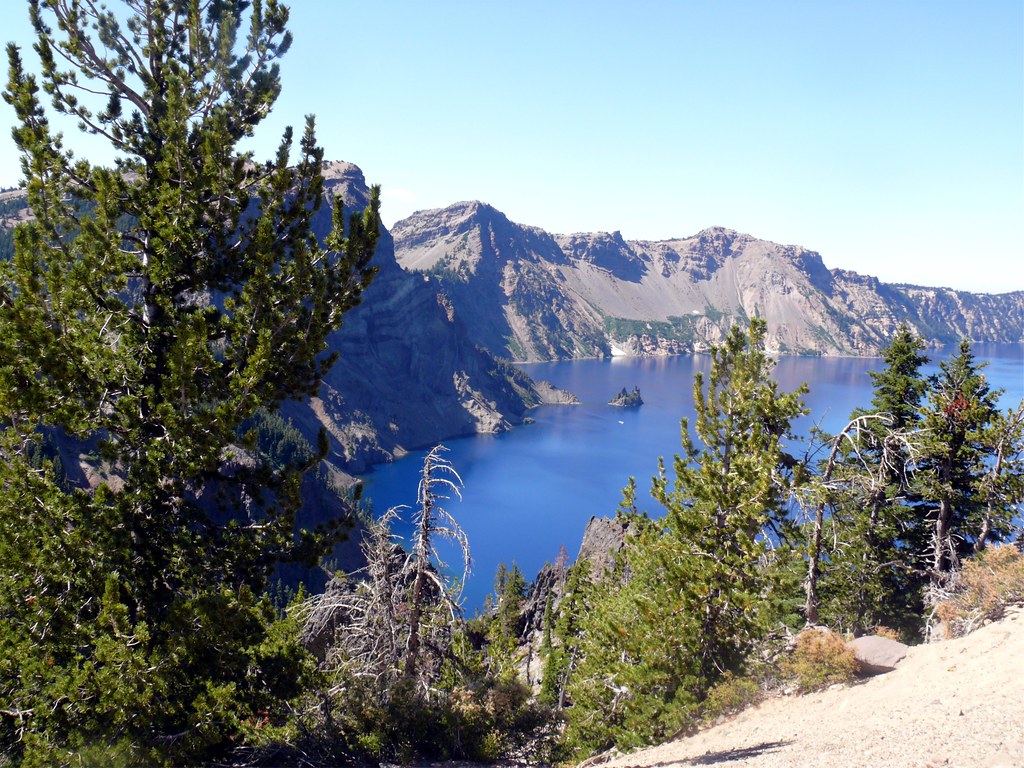
Photo: davidwilson1949 via Flickr (CC BY 2.0)
The Best Hikes Crater Lake has to offer combine caldera rim viewpoints, a descent to the lake, a high summit, and a waterfall reached through old growth forest. Our five choices are Garfield Peak, Cleetwood Cove, Mount Scott, Watchman Peak, and Plaikni Falls. Together, they cover the park’s defining landscapes without requiring backpacking or technical equipment.
Crater Lake occupies the collapsed heart of Mount Mazama, a Cascade volcano whose climactic eruption occurred about 7,700 years ago. The lake surface sits near 6,178 feet, while much of the rim rises above 7,000 feet. That elevation controls every hiking plan. Snow can cover trails well into summer, afternoon weather changes quickly, and visitors arriving from lower elevations often feel the climbs sooner than the mileage suggests.
How the 5 Best Hikes in Crater Lake National Park Capture the Caldera
Each selected trail provides a distinct perspective. Garfield Peak and Watchman Peak look across the intensely blue water toward Wizard Island. Cleetwood Cove descends through the caldera wall to the shoreline. Mount Scott reaches the park’s highest point at 8,929 feet, revealing the broader Cascade Range. Plaikni Falls leaves the rim environment for a cool forest and spring fed waterfall.
Best Hikes Crater Lake: Five Trails at a Glance
| Trail | Round trip distance | Approximate gain | Primary experience |
|---|---|---|---|
| Garfield Peak | 3.4 miles | 1,010 feet | Elevated caldera and Phantom Ship views |
| Cleetwood Cove | 2.2 miles | 700 feet on the return | Legal public access to the lakeshore |
| Mount Scott | 4.4 miles | 1,250 feet | Highest summit in the park |
| Watchman Peak | 1.6 miles | 420 feet | Wizard Island and sunset views |
| Plaikni Falls | About 2 miles | About 100 feet | Old growth forest and a spring fed cascade |
Why Mileage Can Be Misleading
These distances look modest, but elevation, exposure, and volcanic footing increase the effort. Garfield Peak gains roughly 300 feet per mile on average, with steeper sections near the top. Cleetwood Cove reverses the usual hiking rhythm because the strenuous portion comes last. Loose pumice and dust can also reduce traction, particularly on the switchbacks climbing away from the water.
Shade varies sharply among the five routes. Plaikni Falls remains largely forested, while Mount Scott and Garfield Peak cross exposed slopes where sun, wind, and thunderstorms matter. Watchman Peak is short enough for many families, although its open upper switchbacks still require secure footwear and close supervision of children.
Planning Your 5 Best Hikes in Crater Lake National Park
Most visitors approach from the south through Mazama Village or from the north entrance when that seasonal road is open. Rim Village serves as the practical base for Garfield Peak, while the other trailheads are spaced along Rim Drive and Pinnacles Road. The full Rim Drive loop is about 33 miles, but viewpoint stops and slow traffic make it a half day outing even before adding a hike.
Road Access Determines the Hiking Season
Crater Lake receives enormous winter snowfall, commonly leaving deep banks around the rim after lower Cascade trails have melted. Garfield Peak may remain snow covered into early summer, and Mount Scott often clears later than lower routes. Rim Drive is opened in stages as plowing progresses. Northern access, Cleetwood Cove, and eastern trailheads can therefore remain unreachable by vehicle well after Rim Village becomes accessible.
Late July through September usually provides the broadest trail access, although wildfire smoke, heat, or early autumn snow can alter conditions. Entrance fees, road openings, boat operations, and temporary trail restrictions can change, so confirm current details on the official park site before setting out.
What to Carry Above 7,000 Feet
- At least two liters of water per person: Carry more for Mount Scott or when combining trails. The cool rim air can disguise dehydration.
- Traction appropriate to conditions: Sturdy hiking shoes suit dry trails. Lingering snow may require compact traction devices.
- Sun and wind protection: Exposed ridges receive strong ultraviolet radiation, while summit winds can make warm days feel cold.
- A paper map or downloaded map: Cellular coverage is unreliable around sections of Rim Drive.
- A warm layer and rain shell: Thunderstorms and temperature drops can develop quickly at rim elevation.
Where the Best Hikes Crater Lake Routes Begin in the Park
Starting location matters when combining hikes. Garfield Peak begins beside Rim Village, making it easy to pair with overlooks and visitor services. Watchman Peak lies west of the village along Rim Drive. Cleetwood Cove is on the north side of the lake, while Mount Scott and the road to Plaikni Falls occupy the eastern side. Grouping trails by zone avoids repeatedly circling the caldera.
Garfield Peak Delivers the Classic Rim Panorama
Garfield Peak is our strongest all around recommendation for hikers with a few hours and enough fitness for a sustained climb. The trail begins near Crater Lake Lodge in Rim Village and ascends the caldera’s southern wall through mountain hemlock, whitebark pine, and open volcanic slopes. Interpretive signs along the lower trail explain local plants and the geology visible across the basin.
Route, Grade, and Viewpoints
The path gains about 1,010 feet on a generally clear route, passing several natural overlooks before reaching the 8,054 foot summit. Looking east reveals the rocky spires of Phantom Ship, an erosion resistant remnant of ancient volcanic rock. Wizard Island rises to the northwest as a cinder cone formed after Mount Mazama collapsed and the caldera began filling with water.
Near the summit, pumice crunches underfoot and the trail narrows against a steep gray slope. Wind moves through the scattered whitebark pines, then the view opens across the entire lake with almost no foreground obstruction. From this height, boats appear as tiny marks on the water, and the opposite rim looks close despite spanning several miles.
Timing the Climb
Morning generally brings clearer air, cooler temperatures, and a lower chance of thunderstorms. Snowfields can linger on shaded traverses early in the hiking season, creating hazardous runouts above steep terrain. Turn around if firm snow covers the trail and you lack the equipment or experience to cross it safely. In clear summer conditions, allow two to three hours for the round trip, including time at the summit.
Cleetwood Cove Reaches the Water
Cleetwood Cove Trail is the park’s only maintained route providing legal public access to the shore of Crater Lake. Its trailhead sits on the north side of Rim Drive, approximately 11 miles east of North Junction. The descent follows long switchbacks through forest and loose volcanic material to a rocky shoreline near the lake’s deepest basin.
The Climb Begins at the Bottom
Descending 700 feet can feel easy, but every foot must be regained after time beside the water. The return climb is comparable to ascending roughly 65 flights of stairs at elevations above 6,000 feet. Hikers should save water and energy for the ascent, avoid running down dusty switchbacks, and allow slower members of the group to establish a sustainable pace.
Conditions Beside Crater Lake
The shoreline consists largely of angular rock rather than a broad beach. Water temperatures remain cold even during summer, and the lake becomes deep quickly near shore. Swimming is limited to designated access areas, where entering the water requires careful footing. Boat excursions have historically departed from Cleetwood Cove, but hiking access and boat schedules should be treated as separate planning decisions.
Mount Scott Reveals the Wider Cascade Landscape
Mount Scott stands east of the caldera and reaches 8,929 feet, the highest elevation in Crater Lake National Park. Its summit provides a broader geographic view than the rim trails. On clear days, hikers can identify Mount Thielsen to the north, Mount McLoughlin to the south, the Klamath Basin to the southeast, and distant Cascade volcanoes beyond the park boundary.
A Steady Ascent Through Thin Forest
The route begins from eastern Rim Drive and climbs across open pumice slopes dotted with mountain hemlock and whitebark pine. The grade remains persistent rather than technical, with little sustained shade on the upper mountain. Loose volcanic gravel makes the descent surprisingly tiring, so trekking poles can improve control. Allow roughly three hours, adding time if your group is still adjusting to the elevation.
Why Morning Is the Safer Window
Mount Scott’s exposed summit attracts wind and leaves hikers with limited shelter when storms develop. Start early enough to descend before afternoon thunderclouds build over the Cascades. The upper trail may hold snow after the lower rim has melted, and smoke from regional wildfires can erase the long views that justify the climb. A clear forecast matters more here than on any other route in our five.
Watchman Peak Packs a Major View Into a Short Climb
Watchman Peak rises above the western rim to approximately 8,013 feet. The trail begins near Watchman Overlook and gains elevation through open forest before switchbacking to a stone observation station. Its west side position places Wizard Island directly below, with the island’s symmetrical cinder cone, central crater, and lava shoreline visible in unusually clear detail.
The Observation Station and Volcanic Story
The summit structure dates to the park’s early development era and was designed to blend local stonework into the volcanic ridge. From its terraces, hikers can trace the steep inner caldera wall and see how Wizard Island formed during eruptions that followed Mount Mazama’s collapse. The island rises about 763 feet above the lake surface, yet remains far below the surrounding rim.
Planning for Sunset and the Walk Back
Sunset gives the western sky a wide horizon, but the return trail becomes dark quickly beneath the trees. Carry a headlamp for every person, pack an insulating layer, and remain well back from unprotected edges near the summit. Parking can become constrained near popular evening periods. An earlier visit provides the same geological perspective with easier trailhead logistics and fewer cold, windy minutes after sundown.
Plaikni Falls Shows the Park Beyond the Rim
Plaikni Falls occupies a forested drainage along Pinnacles Road, southeast of the lake. The path crosses gentler terrain than the four caldera hikes, passing mature Shasta red fir, mountain hemlock, and lodgepole pine before reaching a spring fed cascade on Sand Creek. Groundwater sustains the flow after seasonal snowmelt declines, making the falls more dependable than many small Cascade waterfalls.
Forest Ecology and Wildflower Habitat
Moisture around the falls supports monkshood, paintbrush, Lewis monkeyflower, and other summer wildflowers. Stay on the established path and viewing area because thin soils compact easily and recover slowly during the short growing season. Mosquitoes can be active near wet ground in early summer, while late summer usually brings drier footing. The shaded corridor also provides a useful alternative when exposed rim trails are hot or windy.
Building a Logical Two Day Hiking Plan
The Best Hikes Crater Lake itinerary works most efficiently when routes are grouped by road corridor. It also reduces the temptation to rush Cleetwood Cove’s return climb or begin Mount Scott too late. A practical sequence is:
- First morning: Climb Garfield Peak from Rim Village while visibility is clear.
- First afternoon: Continue west to Watchman Peak, allowing time for overlooks along the way.
- Second morning: Hike Mount Scott early, then continue toward Plaikni Falls for a cooler, easier walk.
- Separate time block: Reserve Cleetwood Cove for a period when everyone has enough water and energy for the uphill return.
Choosing Your Best Crater Lake Hike
Garfield Peak provides the strongest single introduction to the caldera, while Cleetwood Cove is essential for hikers who want to stand beside the lake. Choose Mount Scott for distant Cascade views, Watchman Peak for a shorter climb above Wizard Island, and Plaikni Falls for forest ecology and gentler grades. Those distinctions make it easier to match the route to weather, fitness, available time, and road access.
Two days allow all five hikes without turning Rim Drive into a race between trailheads. If you have one day, pair Garfield Peak with Watchman Peak or combine Mount Scott and Plaikni Falls on the eastern side. Begin exposed climbs early, treat loose pumice carefully, and preserve enough energy for Cleetwood Cove’s ascent. With that planning, each trail contributes a different piece of Crater Lake’s volcanic landscape.
Want to keep exploring? Browse all our Crater Lake guides and articles for more trip-planning tips and ideas.
Gear & Essentials
Tell us about your trip and we will add what else you will want:
The basics
Worth having in the car whatever the park.
For this trip
Traveling with kids
Bringing a pet
RVing
Backcountry
Winter conditions
On the water
Photography
Accessibility
As an Amazon Associate we earn from qualifying purchases, at no extra cost to you.