Bryce Canyon National Park and Capitol Reef National Park: How to Visit Both on One Trip
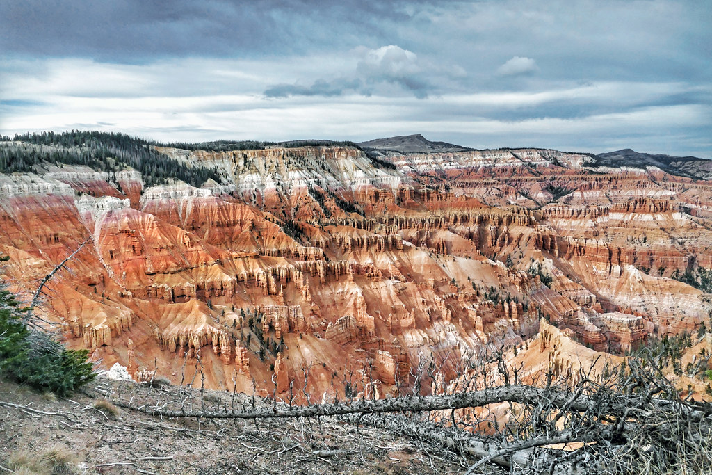
Photo: Bernard Spragg via Flickr (Public Domain Mark)
Bryce Canyon National Park and Capitol Reef National Park fit naturally into one southern Utah road trip, with about 115 miles and roughly 2.5 hours of uninterrupted driving between their visitor centers. Plan at least three full days, although four or five days provide enough time for a hoodoo hike, the Highway 12 drive, Capitol Reef’s Waterpocket Fold, and weather or trail contingencies.
The parks reward different kinds of exploration. Bryce concentrates its best known formations along a high plateau rim, while Capitol Reef spreads across cliffs, canyons, orchards, and desert backroads. Scenic Byway 12 connects them through Red Canyon, Grand Staircase Escalante National Monument, Boulder, and the forested slopes of Boulder Mountain. The connecting drive deserves several hours beyond the basic travel time.
Understand the route from Bryce Canyon National Park to Capitol Reef National Park
The straightforward route leaves Bryce on Utah Highway 63, joins Highway 12, and continues east through Escalante and Boulder. Highway 12 ends near Torrey, where Utah Highway 24 leads east into Capitol Reef and the historic Fruita district. The paved route works for ordinary passenger vehicles, but elevation, winter storms, livestock, and sharp curves can slow progress considerably.
Expect two parks with different terrain
Bryce Canyon occupies the eastern edge of the Paunsaugunt Plateau. Its orange and pink hoodoos formed in the Claron Formation as rain, frost wedging, and erosion opened fins and carved irregular spires. Much of the developed rim stands above 8,000 feet, with Rainbow Point reaching approximately 9,115 feet. Snow can linger here after lower desert roads have become warm and dry.
Capitol Reef centers on the Waterpocket Fold, a nearly 100 mile wrinkle in Earth’s crust created when rock layers were lifted, tilted, and later exposed by erosion. Fruita sits near 5,500 feet beside the Fremont River, almost 3,000 feet below Bryce’s highest developed viewpoint. Cottonwoods and historic orchards occupy the valley floor, while sandstone domes, cliffs, and narrow washes rise around them.
| Planning factor | Bryce Canyon | Capitol Reef |
|---|---|---|
| Primary landscape | Hoodoos and amphitheaters along a plateau rim | Folded rock layers, canyons, domes, and river valley |
| Main visitor elevation | Approximately 8,000 feet | Approximately 5,500 feet at Fruita |
| Typical visit style | Viewpoints, rim walks, and steep descents | Canyon hikes, historic sites, and scenic drives |
| Major weather concern | Cold, snow, ice, and summer lightning | Heat, flash flooding, and exposed terrain |
Allow time for Highway 12
Highway 12 crosses terrain that changes repeatedly. West of Escalante, the road passes pale cliffs and broad views across the Grand Staircase. East of town, it follows the narrow ridge known as the Hogback, where the land drops sharply on both sides. Beyond Boulder, the highway climbs into aspen and conifer forest before crossing Boulder Mountain at elevations near 9,600 feet.
Where the drive tends to take longer
The Hogback and Boulder Mountain require attentive driving, particularly in darkness, high wind, or winter weather. Open range livestock may also be present. Fuel and food are available in gateway communities, but options become less frequent between towns. Our team recommends beginning with a full tank and completing the mountain section in daylight, especially when traveling the route for the first time.
Choose how many days to spend at Bryce Canyon National Park and Capitol Reef
Three days is the practical minimum for travelers who want to hike rather than visit overlooks exclusively. Four days produces a better balance, while five permits a longer Capitol Reef trail or a slower Highway 12 day. Before departure, confirm current entrance fees, road notices, campground reservations, and Bryce shuttle operations on the official park sites.
Follow a compact three-day Bryce Canyon National Park and Capitol Reef itinerary
- Day one: Enter Bryce early, visit Sunrise Point and Sunset Point, then hike below the rim using the Queen’s Garden and Navajo Loop combination. Add Bryce Point near late afternoon if time and road conditions permit.
- Day two: Drive Highway 12 to Capitol Reef. Stop selectively in Escalante or around Boulder rather than attempting every roadside attraction. Reach Fruita with enough daylight to orient yourself along Highway 24.
- Day three: Hike to Hickman Bridge or Cassidy Arch, explore the Fruita historic district, and examine the petroglyph panels east of the visitor center.
This schedule works best when the overnight before day one is near Bryce and the night after day two is near Torrey or Fruita. It leaves little margin for a snowstorm at Bryce, a flash flood watch near Capitol Reef, or a long restaurant stop. Travelers arriving from Las Vegas or Salt Lake City should avoid counting the approach drive as a complete park day.
A four or five day itinerary
Use a fourth day for Capitol Reef’s longer trails, such as the roughly 3.4 mile round trip to Cassidy Arch, or for Grand Wash when flood risk is low. A fifth day can support a more deliberate Highway 12 journey, including a short walk in Grand Staircase Escalante country. These public lands require separate preparation because exposed slickrock, limited shade, and unmarked side roads differ from developed park corridors.
Decide which direction to travel
Traveling from Bryce to Capitol Reef generally places the highest elevation park first. This direction is useful during warm weather because Bryce mornings remain comparatively cool, while Capitol Reef can be scheduled for early hikes on subsequent days. Reversing the order works well for travelers continuing toward Zion or Las Vegas. In winter, choose direction according to the forecast for Boulder Mountain rather than itinerary preference.
Plan the perfect first day in Bryce Canyon National Park
Bryce’s overlooks sit close together, but visiting every pullout adds repetition and consumes hiking time. Prioritize the Bryce Amphitheater, where the densest hoodoo formations appear between Sunrise Point and Bryce Point. Then choose either a descent below the rim or a longer drive south to Natural Bridge, Agua Canyon, and Rainbow Point. The southern viewpoints reveal broader plateau geography rather than the same amphitheater from another angle.
Combine the rim with one hoodoo hike
A practical first visit starts at Sunrise Point, follows the Rim Trail toward Sunset Point, and descends on either Queen’s Garden or the Navajo Loop. Combining those trails creates a circuit of about 3 miles with approximately 600 feet of elevation change. Navajo Loop’s Wall Street side commonly closes when freezing conditions create rockfall hazards, while the Two Bridges side may provide the seasonal alternative.
Below the rim, packed red soil and loose gravel replace the pavement, and the temperature shifts as the trail enters narrow corridors between hoodoos. Switchbacks descend quickly beneath Sunset Point. Footsteps and voices echo against the rock, then fade among ponderosa pines. The return climb feels steeper at this elevation, particularly for visitors who arrived from near sea level that morning.
Match the trail to your available energy
| Trail option | Approximate distance | Best use |
|---|---|---|
| Sunrise to Sunset Rim Trail | 1 mile one way | Easy amphitheater views with minimal elevation change |
| Navajo Loop | 1.3 miles | Short, steep access below the rim |
| Queen’s Garden and Navajo combination | About 3 miles | Best balanced introduction to the hoodoos |
| Figure Eight Combination | About 6.4 miles | Longer immersion for acclimated hikers |
Prepare for Bryce’s altitude and temperature swings
Carry water even in cool weather, because dry air and altitude increase fluid loss without obvious sweating. Pack a warm layer, rain shell, sun protection, and shoes with reliable traction. Summer thunderstorms often develop during the afternoon, and exposed rim sections are poor places to remain when thunder is audible. In cold months, traction devices can be useful where packed snow turns to ice on steep switchbacks.
- Begin strenuous hiking early enough to avoid afternoon heat and thunderstorms.
- Keep food secured and never feed ravens, ground squirrels, or other wildlife.
- Turn around if altitude symptoms progress beyond mild breathlessness or a brief headache.
- Reserve water and energy for the climb back to the rim, which is the hardest part of every descent.
Plan a Capitol Reef day around trail and road conditions
Capitol Reef rewards an early start because many trails have limited shade and afternoon temperatures rise quickly below the cliffs. Begin near Fruita, then pair one substantial hike with the Scenic Drive or Highway 24 corridor. Trying to combine multiple long hikes with remote backroads usually produces rushed stops and unnecessary driving.
Choose between Hickman Bridge and Cassidy Arch
Hickman Bridge is approximately 1.8 miles round trip with about 400 feet of climbing. Its trailhead along Highway 24 makes it efficient for a short visit. Cassidy Arch requires roughly 3.4 miles round trip and about 670 feet of elevation gain from the Grand Wash trailhead. The route climbs steeply onto exposed slickrock, where cairns guide hikers toward the broad sandstone arch.
Use Grand Wash only in stable weather
Grand Wash can be explored from Highway 24 or the Scenic Drive side. Walking the entire wash between trailheads covers approximately 2.2 miles each way, although a shorter out-and-back still reaches the narrowest walls. Because the drainage collects runoff from a much larger area, rain miles away can create flooding where the sky overhead remains blue.
Keep remote drives optional
Capitol Gorge, Cathedral Valley, and the Burr Trail region require more planning than Fruita’s paved corridor. Unpaved roads may become impassable after rain, and Cathedral Valley commonly demands high-clearance capability plus careful assessment of river crossings and road surfaces. Keep these areas for an additional day rather than attaching them to a first-time visit with a fixed departure schedule.
Pack for two elevations and several kinds of weather
A combined trip requires clothing for freezing mornings near Bryce Canyon National Park and warm, exposed hiking at Capitol Reef. Pack by activity rather than by the general Utah forecast. Water, food, traction, and sun protection should remain accessible inside the vehicle instead of buried beneath luggage, particularly during the Highway 12 crossing.
Use a compact two-park checklist
- Water capacity: Carry enough for the planned hike plus a reserve for traffic, heat, or a closed water source.
- Layering system: Bring an insulating layer, rain shell, sun hat, and lightweight warm-weather clothing.
- Footwear: Choose shoes with traction for Bryce’s loose switchbacks and Capitol Reef’s smooth slickrock.
- Navigation: Download maps before leaving town because mobile coverage becomes unreliable along Highway 12 and remote park roads.
- Vehicle supplies: Include a tire gauge, spare tire equipment, flashlight, and emergency food.
Adjust the plan when conditions change
| Condition | Activity to avoid | Practical alternative |
|---|---|---|
| Thunderstorms near Bryce | Exposed rims and high viewpoints | Wait in a substantial building or enclosed vehicle |
| Flash flood watch at Capitol Reef | Grand Wash, Capitol Gorge, and narrow drainages | Use developed historic areas or open roadside viewpoints |
| Snow on Boulder Mountain | Night driving across Highway 12 | Delay the crossing until daylight and road treatment |
| Extreme afternoon heat | Long slickrock hikes | Hike near sunrise and reserve the afternoon for driving |
Avoid the most common scheduling mistakes
Do not place Bryce’s steepest hike immediately after a long approach from Las Vegas or Salt Lake City. Fatigue and altitude compound each other. Another frequent error is leaving Capitol Reef late, then attempting the Hogback after dark. Build each day around one primary objective, add secondary stops only when time remains, and keep at least half a day uncommitted on longer itineraries.
Know what to do when the original itinerary fails
Weather disruptions rarely affect both parks in the same way. Snow may close high-elevation trails at Bryce while Fruita remains dry, whereas summer heat or flood risk may favor additional time on Bryce’s plateau. Check conditions before committing to the interpark drive, then move the flexible day toward the park with safer hiking conditions.
Preserve the essential experiences
If time contracts, protect one below-rim hike at Bryce, the daylight journey across Highway 12, and one Capitol Reef trail. Southern Bryce viewpoints, remote Capitol Reef roads, and additional roadside walks are easier to remove. This order preserves the landscapes that distinguish the trip without forcing dangerous driving or hiking after sunset.
Use paved corridors as the reliable fallback
When dirt roads are wet or a rental agreement prohibits unpaved travel, remain on Highway 24 and the paved portions of the developed park corridor. The Waterpocket Fold remains visible from roadside pullouts, and Fruita provides access to geology, cultural history, and short walks without entering remote terrain. Never drive around a closure gate or across flowing water.
Visit Bryce Canyon National Park and Capitol Reef without rushing the connection
A successful combined trip assigns a different purpose to each day. Bryce supplies concentrated viewpoints and steep hoodoo trails, Highway 12 becomes a scenic travel day, and Capitol Reef provides canyon hiking and broader geological exploration. Three days covers the essentials, while four or five days creates useful protection against altitude, heat, storms, and road delays.
Choose one priority hike in each park, cross Boulder Mountain in daylight, and carry equipment for both alpine and desert conditions. That framework keeps the schedule flexible without making it vague. You will leave with time spent below Bryce’s rim, along the Waterpocket Fold, and on the remarkable road connecting them.
Want to keep exploring? Browse all our Bryce Canyon guides and articles for more trip-planning tips and ideas.
Gear & Essentials
Tell us about your trip and we will add what else you will want:
The basics
Worth having in the car whatever the park.
For this trip
Traveling with kids
Bringing a pet
RVing
Backcountry
Winter conditions
On the water
Photography
Accessibility
As an Amazon Associate we earn from qualifying purchases, at no extra cost to you.