7 Best Hikes in Joshua Tree National Park
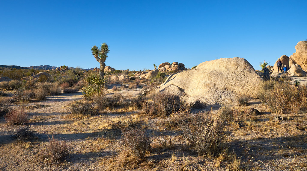
Photo: szeke via Flickr (CC BY-SA 2.0)
Our guide to the Best Hikes Joshua Tree has to offer begins with seven routes that capture the park’s granite formations, Joshua tree woodlands, historic mining sites, palm oases, and broad summit views. For most first visits, Hidden Valley, Barker Dam, and Ryan Mountain form the strongest core itinerary. Lost Horse Mine, Fortynine Palms Oasis, Mastodon Peak, and the Boy Scout Trail add history, solitude, or greater physical challenge.
Joshua Tree National Park covers nearly 800,000 acres where the higher Mojave Desert meets the lower Colorado Desert. Most Joshua trees and famous climbing formations occupy the northwestern highlands around Hidden Valley, Ryan Mountain, and Keys View Road. Creosote flats, ocotillo, fan palm oases, and warmer winter conditions characterize the eastern and southern portions. Choosing hikes from both deserts reveals far more variety than staying near the busiest rock formations.
7 Best Hikes in Joshua Tree National Park at a Glance
Distances alone can be misleading here. A three mile route with 1,000 feet of climbing, loose granite, and full sun demands considerably more effort than a level woodland loop of similar length. The park also has limited natural shade, no reliable backcountry water, and large temperature swings between dawn and afternoon.
Comparing the Best Hikes Joshua Tree Has to Offer
The figures below are practical planning estimates. Trail junctions, optional scrambles, and parking location can slightly change recorded mileage and elevation gain.
| Hike | Distance | Approximate gain | Typical difficulty | Primary experience |
|---|---|---|---|---|
| Hidden Valley | 1 mile loop | 100 feet | Easy | Granite walls and Joshua trees |
| Barker Dam | 1.1 mile loop | 50 feet | Easy | Ranching history and seasonal water |
| Ryan Mountain | 3 miles round trip | 1,050 feet | Strenuous | High summit panorama |
| Lost Horse Mine Loop | 6.5 mile loop | About 850 feet | Moderate | Mining ruins and open ridges |
| Fortynine Palms Oasis | 3 miles round trip | About 600 feet cumulative | Moderate | Native fan palm oasis |
| Mastodon Peak Loop | 2.4 mile loop | About 400 feet | Moderate | Colorado Desert geology |
| Boy Scout Trail | About 8 miles one way | Roughly 1,200 feet of net change | Strenuous | Backcountry traverse |
How many hikes fit into one day
Hidden Valley and Barker Dam combine well because their trailheads sit along the same northern park corridor. Allowing time to examine rock formations and historic features, both can fill a relaxed half day. Ryan Mountain requires a separate block of two to three hours and is best attempted early, especially when daytime temperatures rise.
Fortynine Palms Oasis sits outside the main park road system near the town of Twentynine Palms, while Mastodon Peak begins near Cottonwood in the south. Pairing either with Hidden Valley creates substantial driving. The Boy Scout Trail presents a different logistical problem because its endpoints are separated, so through hikers need two vehicles or a planned pickup.
How to Navigate the Best Hikes Joshua Tree Has to Offer
Joshua Tree has no central valley connecting every major trail. Park Boulevard links the West Entrance, Hidden Valley, Ryan Mountain, and the North Entrance, forming the principal hiking corridor. Pinto Basin Road drops southeast from the higher Mojave Desert toward Cottonwood, crossing increasingly open Colorado Desert terrain along the way.
The Mojave Desert hiking corridor
Hidden Valley, Barker Dam, Ryan Mountain, Lost Horse Mine, and the northern Boy Scout trailhead lie in the cooler Mojave portion of the park. Elevations commonly range from about 4,000 to more than 5,000 feet. Monzogranite outcrops dominate the scenery, created when deeply buried molten rock cooled and later became exposed through uplift, erosion, and chemical weathering.
The Joshua tree is a branching yucca adapted to this higher desert. Woodlands are especially photogenic early and late in the day, when low sunlight separates individual limbs from the surrounding rock. Winter can bring freezing nights and occasional snow at these elevations, while spring produces localized displays of phacelia, lupine, and desert dandelion after favorable rainfall.
The warmer Colorado Desert
South and east of the transition zone, Joshua trees thin out and creosote bush, cholla, ocotillo, and palo verde become more prominent. Mastodon Peak provides the most accessible introduction to this landscape. Fortynine Palms occupies a separate canyon along the park’s northeastern edge, where groundwater supports California fan palms beneath exposed ridges.
Logistics to verify before leaving
Cell reception is unreliable, trailheads can fill early, and there is no dependable drinking water along these routes. Entrance requirements, closures, fire restrictions, and facility availability can change, so confirm current details on the official park site before driving into the park.
- Download an offline park map before reaching the entrance.
- Carry at least one gallon of water per person for a full hiking day, with additional water during warm weather.
- Pack sun protection even in winter, including a brimmed hat, sunglasses, and sunscreen.
- Bring a headlamp if starting before sunrise or combining several trails.
- Keep food secured inside a vehicle or closed pack because ravens and rodents investigate unattended supplies.
Easy Introductions to the 7 Best Hikes in Joshua Tree National Park
Hidden Valley and Barker Dam provide the highest concentration of characteristic scenery per mile. Both are short loops, but each rewards slow observation. Granite passages conceal plants, old livestock infrastructure, and evidence that seemingly dry basins can briefly hold water after storms.
1. Hidden Valley Nature Trail
The one mile loop enters an enclosed basin through a narrow break in the boulders. Local tradition connects Hidden Valley with cattle rustlers, although much of that story remains difficult to document. The physical setting is clearer: weathered monzogranite walls surround a pocket of pinyon pine, juniper, scrub oak, yucca, and Joshua trees sheltered from the broad surrounding plains.
The path crosses compact sand, stone steps, and short uneven sections without sustained climbing. Interpretive signs explain plant adaptations and geology, making this our preferred first hike for understanding the park. Early morning offers cooler temperatures and cleaner light on formations such as the Great Burrito and nearby climbing walls.
2. Barker Dam Loop
Barker Dam combines desert ecology with ranching history on a roughly 1.1 mile circuit. Cattlemen enlarged the reservoir in the early twentieth century, building against natural granite. Water levels depend heavily on recent precipitation, and the basin may be dry. When water is present, it can attract birds and desert bighorn sheep, particularly during quieter hours.
Continue around the complete loop rather than turning back at the dam. The western side passes petroglyphs, although some markings were painted over during a film production decades ago. Sandy washes and low rock passages then return toward the trailhead through open Joshua tree habitat.
Ryan Mountain, the Park’s Essential Summit Hike
Ryan Mountain rises to 5,457 feet near the center of the developed northern corridor. Its trail gains about 1,050 feet in 1.5 miles, making it the steepest sustained climb among the shorter hikes on this list. Stone steps and an exposed traverse lead toward a broad summit with views across several distinct basins.
3. Ryan Mountain Trail
Begin early because almost the entire route faces open sky. The ascent looks toward Queen Valley and the Wonderland of Rocks, while higher switchbacks reveal the Little San Bernardino Mountains. On clear days, the summit panorama reaches toward San Gorgonio Mountain, whose 11,503 foot summit is the highest point in Southern California.
Near the top, the trail narrows through fractured granite and low pinyon vegetation. Boots scrape on coarse crystals underfoot, wind replaces the still air of the lower slope, and the parked cars shrink into pale dots beside Park Boulevard. The final rise opens abruptly onto a rounded summit where Joshua tree plains, granite mounds, and distant mountain ridges occupy separate layers of the view.
Timing and conditions on the ascent
Allow two to three hours, including time at the summit. Afternoon heat intensifies the climb from late spring into early fall, and summer temperatures can make a midday attempt unsafe. Winter brings better visibility but also strong wind, ice, or brief snow cover. Turn around if thunder develops because the summit and upper ridge provide little protection.
Mining History on the Lost Horse Loop
Lost Horse Mine occupies an exposed ridge southwest of Keys View Road. The surrounding country feels broader and less enclosed than Hidden Valley, with long views across Lost Horse Valley toward distant desert ranges. The full loop adds rolling terrain beyond the mine, while an out and back visit to the historic structures provides a shorter alternative for hikers who do not want to complete the entire circuit.
4. Lost Horse Mine Loop
The mine operated intermittently from the late nineteenth century into the 1930s and produced thousands of ounces of gold and silver. Its ten stamp mill crushed ore so valuable material could be separated from waste rock. Stabilized mill equipment and foundations remain visible, but shafts and fragile structures should be viewed from outside protective barriers. Abandoned mine openings can conceal unstable edges, deep drops, and poor air.
Choosing the loop or shorter return
The most direct approach follows an old mine road for about two miles to the mill. Completing the 6.5 mile loop adds open ridges, sandy washes, and less obvious junctions. Traveling clockwise generally puts the mine earlier in the hike, which helps visitors assess heat and water before entering the quieter back section. Carry offline navigation because informal tracks around mining remains can resemble the maintained route.
Two Desert Oases With Different Personalities
Fortynine Palms Oasis and Mastodon Peak both feature native California fan palms, yet the routes cross different terrain. Fortynine Palms requires climbing over a rocky ridge in each direction. Mastodon Peak links an oasis, old mining remains, granite formations, and an optional summit scramble within a compact loop near the park’s southern entrance.
5. Fortynine Palms Oasis Trail
The trail climbs through exposed granitic slopes before descending into a canyon where groundwater reaches the surface. California fan palms retain skirts of dead fronds that shelter insects, birds, and bats. The oasis is also important habitat for desert bighorn sheep, so hikers should avoid approaching wildlife or lingering directly beside limited water. Remember that the return begins with an uphill climb out of the canyon.
6. Mastodon Peak Loop
Starting near Cottonwood Spring, this loop passes palms fed by a fault controlled water source before crossing sandy washes toward Mastodon Mine. The route then reaches the base of Mastodon Peak, a granite knob with views over Pinto Basin and the Eagle Mountains. Reaching the highest rocks involves an exposed scramble, but hikers can remain on the established loop and still obtain broad views from the saddle.
Comparing the critical route challenges
| Trail | Main challenge | Useful turnaround decision |
|---|---|---|
| Fortynine Palms Oasis | Exposed climbing in both directions | Turn back at the ridge if heat or water consumption is already excessive |
| Mastodon Peak | Loose footing and optional scrambling | Skip the summit rocks if wind, exposure, or route finding feels uncomfortable |
The Boy Scout Trail as a Backcountry Traverse
The Boy Scout Trail connects the higher Joshua tree country near Park Boulevard with the lower Indian Cove area. Along the way, it skirts the Wonderland of Rocks, crosses washes bordered by pinyon and juniper, and descends toward increasingly dry creosote habitat. Its length, elevation change, and separated trailheads make it the most logistically demanding selection among the Best Hikes Joshua Tree visitors commonly consider.
7. Boy Scout Trail
Most through hikers travel downhill from the southern trailhead toward Indian Cove, although either direction is possible. The upper miles pass sandy flats and granite outcrops before the route enters rougher canyon terrain. Footprints can spread across washes, so navigation requires more attention than on the park’s short nature trails. Summer conditions are unsuitable for most hikers because shade and emergency water are absent.
Planning the two trailhead transfer
A successful traverse depends on transportation arranged before anyone starts walking. The road journey between trailheads is much longer than the hiking distance because vehicles must travel around the Wonderland of Rocks. Every driver should save both trailhead locations offline and carry keys securely.
- Leave a retrieval vehicle at the finishing trailhead.
- Record its parking location and identifying details.
- Drive all hikers to the starting point in the second vehicle.
- Carry enough water to complete the route without relying on caches.
- Set a turnaround time based on daylight, pace, and the slowest hiker.
Choosing Your Plan for the 7 Best Hikes in Joshua Tree National Park
First time visitors should prioritize Hidden Valley for geology, Barker Dam for cultural history, and Ryan Mountain for the park’s clearest high elevation panorama. Add Lost Horse Mine when a half day is available for a longer historical route. Fortynine Palms Oasis and Mastodon Peak work better as separate objectives because each sits away from the central Park Boulevard corridor.
The Boy Scout Trail belongs in a plan built around transportation, navigation, and sustained desert travel. Whichever routes you choose, start with realistic mileage, protect the park’s scarce water sources, and leave abandoned structures untouched. These seven hikes collectively reveal the Mojave woodlands, Colorado Desert slopes, palm oases, granite summits, and working landscapes that define Joshua Tree National Park.
Want to keep exploring? Browse all our Joshua Tree guides and articles for more trip-planning tips and ideas.
Gear & Essentials
Tell us about your trip and we will add what else you will want:
The basics
Worth having in the car whatever the park.
For this trip
Traveling with kids
Bringing a pet
RVing
Backcountry
Winter conditions
On the water
Photography
Accessibility
As an Amazon Associate we earn from qualifying purchases, at no extra cost to you.