5 Best Hikes in Yellowstone National Park
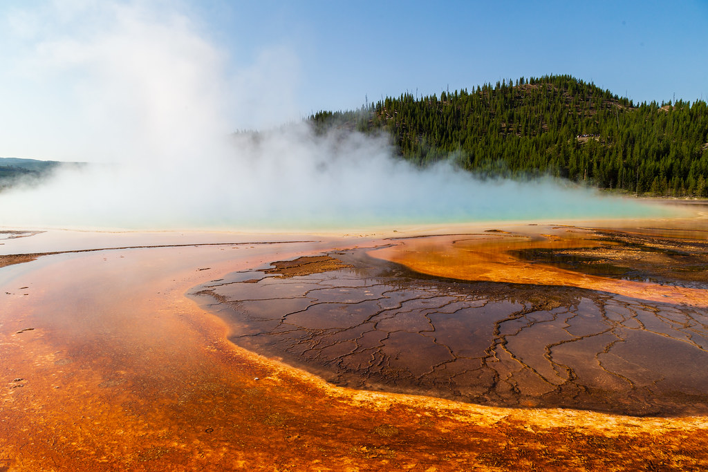
Photo: aparlette via Flickr (CC BY 2.0)
The Best Hikes Yellowstone National Park visitors can take often lead away from the famous roadside boardwalks. Yellowstone covers 2.2 million acres, and its hiking trails reveal a park of rhyolite plateaus, glacial valleys, waterfalls, subalpine forests, and peaks above 10,000 feet. Thermal features remain part of the experience, but they are only one layer of the landscape.
Our five choices span Yellowstone’s major hiking environments: the Midway Geyser Basin, the Grand Canyon of the Yellowstone, the Washburn Range, the Absaroka Mountains, and the wildlife-rich northeast. Drive times between them can exceed two hours, so the most effective plan groups each hike with the surrounding park corridor rather than attempting the list in numerical order.
How We Chose the 5 Best Hikes in Yellowstone National Park
A representative route through five different landscapes
We favored trails that reveal something distinctive about Yellowstone. Fairy Falls provides an elevated look at Grand Prismatic Spring and reaches a 200-foot waterfall. Point Sublime follows the rim of a hydrothermally altered canyon. Mount Washburn opens views across the Yellowstone Caldera, while Avalanche Peak enters the steeper Absaroka terrain east of Yellowstone Lake. Trout Lake adds a compact wildlife walk in the Lamar Valley region.
This selection also avoids filling the list with similar summit climbs or thermal-basin walks. The routes range from roughly 1.2 to 6.4 miles, allowing hikers to match effort with weather, altitude, and the time available. Trail distances can vary slightly according to the mapped turnaround point and any viewpoint spurs.
What every Yellowstone hiker should carry
Yellowstone weather changes quickly because much of the park lies above 7,000 feet. Snow can linger on high trails into summer, while exposed areas may become hot and dry during the afternoon. Our team considers the following equipment essential even for shorter routes:
- Bear spray carried where it can be reached immediately, rather than buried in a pack
- At least two liters of water for moderate hikes, with additional water for exposed summit routes
- A warm layer and waterproof shell, even when the morning begins under clear skies
- Sun protection, since elevation increases ultraviolet exposure
- A downloaded trail map because mobile coverage is unreliable
- Sturdy footwear for loose volcanic soil, roots, mud, and lingering snowfields
Best Hikes in Yellowstone National Park: Compare Them at a Glance
The figures below describe the versions of the routes covered in this guide. Mount Washburn is approached from Dunraven Pass, while the canyon hike begins at Artist Point. These details matter because alternate trailheads can produce different distances and elevation totals.
| Hike | Distance | Approximate gain | Best general season | Defining feature |
|---|---|---|---|---|
| Fairy Falls and Grand Prismatic Overlook | About 5 miles | About 300 feet | Late spring through fall | Thermal-basin panorama and waterfall |
| Point Sublime from Artist Point | About 3 miles | About 350 feet | Late spring through fall | Yellowstone canyon rim |
| Mount Washburn from Dunraven Pass | About 6.4 miles | About 1,400 feet | Mid-summer through early fall | 10,219-foot summit |
| Avalanche Peak | About 4.7 miles | About 2,100 feet | Mid-summer through early fall | Steep Absaroka summit route |
| Trout Lake | About 1.2 miles | About 200 feet | Late spring through fall | Wetland wildlife habitat |
How to Sequence the 5 Best Hikes in Yellowstone National Park
Fairy Falls fits naturally into a day along the western geyser-basin corridor between Old Faithful and Madison. Point Sublime belongs with the Canyon Village area. Mount Washburn lies north of the canyon on the road toward Tower Junction, while Trout Lake is farther east near the Lamar Valley. Avalanche Peak begins along the East Entrance Road near Yellowstone Lake and is geographically isolated from the western thermal areas.
Seasonal access and trail conditions
Lower trails may become walkable weeks before Mount Washburn and Avalanche Peak lose their snow. Afternoon thunderstorms are especially important on exposed ridges, where lightning and falling temperatures can turn a summer climb into an urgent descent. Road openings, temporary wildlife closures, entrance requirements, and trail restrictions change, so confirm current details on the official park site before fixing an itinerary.
Fairy Falls and the Grand Prismatic Overlook
Trailhead and route profile
The Fairy Falls Trail begins near Midway Geyser Basin and initially follows a broad path across the Firehole River flats. The overlook spur branches uphill after roughly 0.6 mile. Returning to the main trail and continuing to Fairy Falls creates an outing of about five miles, with modest elevation gain and little technical difficulty.
The overlook above Grand Prismatic Spring
The hillside viewpoint explains Grand Prismatic Spring better than the basin-level boardwalk does. From above, visitors can see the deep blue center, the green and yellow transition zones, and orange microbial mats spreading into the surrounding ground. Those colors correspond partly to temperature gradients and communities of heat-tolerant microorganisms. Steam can obscure the pool on cold mornings, making a warmer part of the day preferable for visibility.
The final approach to Fairy Falls
Beyond the overlook junction, the trail crosses lodgepole pine forest growing on relatively young volcanic terrain. Fairy Falls drops about 200 feet from a narrow ledge, breaking into spray before reaching the shallow pool below. The final approach can feel cooler than the open basin because the forest holds shade and the waterfall moves cold air through the clearing.
Point Sublime Along the Grand Canyon’s South Rim
Starting from Artist Point
Artist Point provides the familiar view toward 308-foot Lower Falls, but the trail to Point Sublime quickly leaves the busiest overlook. The path follows the south rim for approximately 1.5 miles each way, repeatedly climbing and descending through forest. Erosion has created steep edges, narrow tread, and exposed drop-offs, so this route requires more attention than its moderate mileage suggests.
Walking through Yellowstone’s altered volcanic rock
Underfoot, pale dust shifts across roots while the canyon opens between lodgepole trunks. Wind carries the roar of the river upward, although the water lies hundreds of feet below. At exposed bends, the walls appear yellow, rust-red, white, and gray. Hydrothermal fluids altered the rhyolitic rock, weakening it and helping the river carve the canyon seen today.
Why Point Sublime feels different from Artist Point
Point Sublime looks into the canyon rather than directly at Lower Falls. The narrower view emphasizes depth, pinnacles, and the Yellowstone River continuing north toward Tower. Shade is limited at the outer viewpoint, and loose ground near the rim demands care, particularly after rain. Hikers should remain on the established trail because the altered rock can crumble under body weight.
Mount Washburn from Dunraven Pass
A steady climb into the Washburn Range
The Dunraven Pass route follows an old service road through open slopes and whitebark pine habitat. The gradient remains steady rather than technical, but the starting elevation near 8,900 feet makes the ascent more demanding than its tread suggests. Look back during the climb for views toward the Grand Canyon, Hayden Valley, and the Absaroka Range. Snowfields commonly persist after lower park trails have dried, and strong winds can make the broad upper ridge considerably colder than the trailhead.
Reading the landscape from 10,219 feet
Mount Washburn’s summit provides one of the clearest introductions to Yellowstone’s enormous scale. The Yellowstone Caldera stretches across much of the southern view, while Yellowstone Lake occupies a broad depression beyond the forested plateaus. Bighorn sheep sometimes use the rocky summit slopes, and hikers should give them ample space rather than blocking their route. The summit lookout has long supported fire detection, although hikers should plan to be self-sufficient and descend before nearby thunderstorms develop.
- Begin early enough to avoid afternoon lightning on the exposed upper mountain.
- Keep food secured because ground squirrels and other wildlife frequent popular rest areas.
- Turn around if clouds build rapidly, thunder becomes audible, or graupel begins accumulating.
Avalanche Peak Above Yellowstone Lake
Yellowstone’s steepest hike on this list
Avalanche Peak begins near the eastern side of Yellowstone Lake and climbs sharply through mixed conifer forest. The route gains elevation almost continuously before emerging onto loose talus, where footing becomes slower and the trail can divide into several worn paths. This is a high-effort climb suited to hikers comfortable with sustained grades and exposed alpine terrain. Trekking poles help during the descent because volcanic rubble and small stones readily shift underfoot.
The summit ridge and Absaroka geology
The upper ridge rises to approximately 10,568 feet and looks across Yellowstone Lake toward the central plateau. To the east, the Absaroka Range displays sharper relief than Yellowstone’s broad rhyolite uplands. These mountains consist largely of volcanic material produced by ancient eruptions that predate the park’s younger caldera system. Travelers comparing the Best Hikes Yellowstone National Park provides should choose Avalanche Peak for strenuous climbing, expansive lake views, and a distinctly alpine setting rather than thermal features.
Wildlife awareness on the East Entrance corridor
Grizzly bears use the surrounding forests and alpine slopes, particularly where seasonal foods concentrate. Hike in a group, make noise in vegetation or near blind corners, and keep bear spray immediately accessible. Pikas may be heard calling from talus fields, while marmots occupy larger rock piles. September brings colder conditions and increased bear activity in parts of the range, making conservative route decisions especially important late in the hiking season.
Trout Lake in the Northeast Corner
A short climb to productive wetland habitat
The Trout Lake trail rises steeply from the Northeast Entrance Road before leveling beside a small lake enclosed by forest and open meadow. A path circles portions of the shoreline, where marshy ground and inlet channels create habitat for waterfowl, amphibians, and aquatic mammals. River otters are occasionally observed hunting or moving between the water and bank. Morning and evening generally provide quieter conditions, but hikers must remain alert because bears also travel through this productive habitat.
Cutthroat trout and responsible viewing
Yellowstone cutthroat trout move into the lake’s inlet to spawn, often becoming visible in shallow water during the seasonal run. Their presence can attract otters and other predators, giving careful observers a compact lesson in the northeast ecosystem. Stay back from the channel edges, avoid trampling wet vegetation, and use binoculars rather than approaching wildlife. Trout Lake pairs well with roadside wildlife viewing in Lamar Valley, where long sightlines improve the chances of seeing bison, pronghorn, coyotes, or distant wolves.
| Choose this hike | When your priority is | Main planning concern |
|---|---|---|
| Mount Washburn | Broad caldera and mountain views | Altitude, wind, and lightning exposure |
| Avalanche Peak | A strenuous alpine summit | Steep grades, loose talus, and bear habitat |
| Trout Lake | Wildlife observation with limited mileage | Giving animals space near the shoreline |
Choosing the Right Hike Among Yellowstone National Park’s 5 Best
Fairy Falls suits visitors who want geothermal color and a moderate forest walk, while Point Sublime reveals the canyon’s hydrothermally altered walls. Mount Washburn offers the strongest all-around panorama. Avalanche Peak demands the most fitness and comfort on loose alpine ground, and Trout Lake provides the best compact wildlife outing. Select one route near the corridor you are already exploring, since Yellowstone’s road distances make crossing the park for a single hike an inefficient use of daylight.
Altitude, weather, and wildlife should shape the final decision more than mileage alone. Start summit routes early, carry bear spray on every trail, and leave enough time to return before darkness or afternoon storms. With those fundamentals covered, these five hikes provide a practical cross-section of Yellowstone: thermal basins, canyon rims, volcanic plateaus, rugged Absaroka slopes, and the biologically rich northeast corner.
Want to keep exploring? Browse all our Yellowstone guides and articles for more trip-planning tips and ideas.
Gear & Essentials
Tell us about your trip and we will add what else you will want:
The basics
Worth having in the car whatever the park.
For this trip
Traveling with kids
Bringing a pet
RVing
Backcountry
Winter conditions
On the water
Photography
Accessibility
As an Amazon Associate we earn from qualifying purchases, at no extra cost to you.